Volume II: Archaic Ceremonial Monuments
This scholarship was compiled by John Vincent Bellezza through a fellowship for East Asian Archaeology and Early History from the American Council of Learned Societies with funding from the Henry Luce Foundation. The technical work, design, copy editing, and preparation in digital format was done at the University of Virginia by the Tibetan & Himalayan Library with a grant from the Luce Foundation and the US Department of Education TICFIA Program.
In particular, I salute the outstanding expertise of the following individuals involved in the technical work and editing. In alphabetical order:
- Geoffrey Barstow, editing
- Tom Benner, map preparation
- Quentin Devers, editing and map preparation
- Mark Ferrara, web-design
- Nathaniel Grove, technical support
- William McGrath, editing
- Alison Melnick, editing
- Andres Montano, technical support
- David Newman, technical support
- Mickey Stockwell, editing
- Steven Weinberger, editing, technical support, project management
- Michael White, editing
Since 1994, this inventory of pre-Buddhist archaeological sites in Upper Tibet has been made possible through the friendship and cooperation of many fine people. I warmly thank the more than 5000 residents of Upper Tibet who helped guide me to their archaeological heritage and who patiently tried to answer my many questions about them. I cordially acknowledge the assistance and guidance of numerous Tibet Autonomous Region provincial, prefectural, county, and township authorities. Their help was indispensable in the pursuance of my work. Moreover, I could not have comprehensively explored sites throughout the region without the active and sustained sponsorship of the Tibetan Academy of Social Sciences and the Ngari Xiangxiong Cultural Exchange Association. These institutions and the people who work for them command my deep admiration. I also want to thank the crews of drivers, guides, cooks and assistants who accompanied me on most expeditions. They performed in an exemplary fashion in what were challenging circumstances.
The organizations and institutions that financially supported my work over the last twelve years deserve my greatest appreciation and special credit. I simply could not have done my work without their support. I list those who have awarded me grants and fellowships in alphabetical order:
- American Council of Learned Societies in conjunction with the Henry Luce Foundation (New York)
- Asian Cultural Council (New York)
- Kalpa Group (Oxford)
- National Geographic Expeditions Council (Washington D. C.)
- Shang Shung Institute (Merigar)
- Shelley & Donald Rubin Foundation (New York)
- Spalding Trust (Stowmarket)
- Tibetan Medical Foundation (Weslaco)
- Trust for Mutual Understanding (New York)
- Unicorn Foundation (Atlanta)
I express profound gratitude to my Tibetan Bön teachers of history and literature: His Holiness Menri Tridzin Ponsé Lama, Loppön Tendzin Namdak and Yungdrung Tendzin. It is also with much pleasure that I extend my thanks to Gene Smith (Tibetan Buddhist Resource Center), Ernst Steinkellner (Universität Wien), David Germano (University of Virginia), and Charles Ramble (Oxford University) for their academic support and friendly encouragement. Finally, I am delighted to acknowledge the goodwill and assistance of John Bellezza (Southampton), Mickey Stockwell (Boulder), Mary Lanier (New York), and Karen Harris (Trinidad). Without the moral support and practical aid of these very fine individuals, my exploratory and scholarly endeavors could not have come to fruition.
The upper portion of the Tibetan Plateau, a land of large lakes, lofty peaks, interminable plains, and deep gorges, stretches north and west of Lhasa for 1500 km. Bound by high mountain ranges on all sides and averaging 4600 m above sea level, Upper Tibet gave rise to an extraordinary civilization in antiquity. Beginning about 3000 years ago, a chain of mountaintop citadels, temples, and intricate burial complexes appeared in this vast region of some 600,000 square kilometers. These monuments were part and parcel of a unique human legacy, which flourished until the Tibetan imperium and the annexation of Upper Tibet by the Pugyel emperors (tsenpo) of Central Tibet. Gradually the unique beliefs, customs and traditions of archaic Upper Tibet yielded to a pan-Tibetan cultural entity that arose in conjunction with Vajrayāna Buddhist teachings.
A millennium ago, Buddhist domination of Tibet spawned a new civilization, one in which the celebrated Lamaist religions of Bön and Buddhism came to hold sway. The inexorable march of time and the ascent of the new religious order slowly but surely clouded the memory of the earlier cultural heritage. As a result, many of the ancient achievements of the Upper Tibetan people were forgotten. All that remains are preserved in the impressive monumental traces of the region. Antiquities of Zhang Zhung attempts to reclaim these past glories by systematically describing the visible physical remains left by the ancient inhabitants of Upper Tibet.
The residential and ceremonial monuments of Upper Tibet, established by what can be termed the “archaic” cultures of the region (Zhang Zhung and Sumpa of the literary records), strongly contrast with those built in the central and eastern portions of the plateau in the same span of time. There are very substantial differences between the archaeological makeup of the archaic cultural horizon (circa 1000 BCE to 1000 CE) and that of the Lamaist era (circa 1000 CE to 1950 CE) in Upper Tibet. The unique monumental assemblage of Upper Tibet delineates the bounds of a paleocultural complex squarely based in the uplands of the plateau. The special physical hallmarks and highland homeland of this ancient culture set it apart from other Bodic cultures, which arose in the central and eastern parts of the Tibetan Plateau. The paleocultural world of Upper Tibet is readily distinguished from those civilizations that appeared in adjoining lands to the south, west and north. In the archaic cultural horizon the Upper Tibetans constructed highly durable all-stone elite residences, temples and castles, developing stone working techniques particularly suited to their extremely harsh natural environment. They also designed and built elaborate burial complexes containing many types of ritual structures made entirely of stone. The use of stone corbelling for the construction of roofs and the erection of pillars in peculiar configurations for ceremonial purposes reached a very high level of proficiency in Upper Tibet. The eminently practical qualities of this architecture have helped to insure that the remains of a surprising number of monuments have endured to the present day.
Although the design and construction of the monumental assemblage of archaic Upper Tibet is highly distinctive, affinities with other archaeological cultures of the plateau and steppes certainly exist. During the first millennium BCE and first millennium CE, a tremendous amount of cross-fertilization occurred throughout Inner Asia. These manifold cultural links are explored in depth in my last book, Zhang Zhung: Foundations of Civilization in Tibet. This monograph furnishes the analytical framework and data necessary to begin to comprehend the chronological, economic and cultural dimensions of the sites surveyed in the present work.
Antiquities of Zhang Zhung systematically describes the physical remains of 404 Upper Tibetan monumental sites documented since 2001.1 It is an inventory of archaic or prospective archaic archaeological sites. These sites differ from Lamaist monuments in terms of morphology, function, mythology, and geographic orientation. This catalogue of archaeological sites should prove useful to scholars working in a variety of disciplines. As a reference work, it is well suited to provide a perspective for subsequent studies devoted to better understanding the archaic physical and cultural environment of Upper Tibet and other regions of Inner Asia. It presents uniform sets of physical and cultural data for each of the sites surveyed to produce a coherent view of the monumental vestiges scattered across the Upper Tibetan landscape. As a compendium of archaeological sites, this work is primarily quantitative (descriptions of the remaining physical evidence) in nature. To a lesser degree, it also provides qualitative information (analyses of the ideological groundwork underlying the physical manifestations) in order to elucidate various abstract aspects of the monuments. This methodological approach, borrowing from archaeological, literary and ethnographic sources of information, permits an integral picture of ancient Upper Tibetan archaeological assets to emerge. By bringing Upper Tibet’s fascinating past into clearer focus, we begin to acquaint ourselves with the formative elements in the development of Bodic civilization. In turn, this permits us to move one step closer to understanding the Tibetan Plateau’s place in the Eurasian cultural mosaic of yore.
An inspection of the sites surveyed opens a window onto a remarkable Tibetan heritage. Rather than a cultural backwater, upland Tibet emerges as a nexus of technological and cultural brilliance. A chain of citadels circumscribing the region reflects the existence of a vibrant social order in which agriculture played a vital role. From the first millennium BCE onwards, a warrior and priestly elite appears to have founded and occupied these citadels. The sheer number of fortified sites built on summits shows that martial struggle was a prominent preoccupation (which is mirrored in the Tibetan literary record). The top strata of ancient Upper Tibetan society constructed all-stone temples and residences in which the cultural life of the region reached a crescendo. Troglodytic communities sprang up wherever there were natural caves or where it was possible to excavate earthen formations. In the cultural hothouse environment of first millennium BCE and early first millennium CE Inner Asia, Upper Tibet appears to have been one of several regions with superior intellectual and military capabilities. The legendary status accorded Zhang Zhung in Tibetan literature buttresses the archaeological record, indicating that Upper Tibet had indeed reached a considerable level of human attainment before the spread of Buddhism.
The existence of intricate burial rites is echoed in the many tombs and necropoli that dot the entire region. These architecturally diverse funerary sites allude to sophisticated eschatological concepts and practices prevalent in early Upper Tibet. The mortuary archaeological evidence also records yawning divisions in wealth and social status, a sign that the region possessed a hierarchical society with deep social, economic and political divisions. This puts the highland variant of Bodic civilization in line with surrounding civilizations of the Iron Age and the classical period, where social stratification, economic diversification and warfare were rampant. While many linkages between the empirical and textual perspectives remain hypothetical, the intellectual profundity of matters related to death in both the literary and archaeological records is unmistakable and very significant. In Zhang Zhung: Foundations of Civilization in Tibet, I examine the interconnections between the mortuary sites of Upper Tibet and the archaic funerary beliefs and rituals of the Tibetan texts.2
So much still needs to be discovered before we can find answers to even basic questions concerning the polity and people of ancient Upper Tibet. Nevertheless, the good news is that step-by-step an understanding of the region’s archaeological character is being secured. This increase in our knowledge should pave the way to new insights into the origins and development of Tibetan civilization, as well as to a more refined appreciation of the ancient cultural complexion of Inner Asia. It is in the service of such aims that the present work has been composed.
- ^ For the findings of my earlier expeditions see: Bellezza, Antiquities of Upper Tibet; Bellezza, “Gods, Hunting and Society: Animals in the Ancient Cave Paintings of Celestial Lake in Northern Tibet,” East and West 52 (2002): 347-396; Bellezza, Antiquities of Northern Tibet; Bellezza, “Bon Rock Paintings at gNam mtsho: Glimpses of the Ancient Religion of Northern Tibet,” Rock Art Research 17, no. 1 (2000): 35-55; Bellezza, “A Preliminary Archaeological Survey of Da rog mtsho,” The Tibet Journal 24, no. 1 (1999): 56-90; Bellezza, “Notes on Three Series of Unusual Symbols Discovered on the Byang thang,” East and West 47, nos. 1-4 (1997): 395-405; Bellezza, Divine Dyads.
- ^ Another crucial archaeological asset of Upper Tibet is rock art, which provides a rich record of the archaic way of life in the region. Dozens of sites in which petroglyphs and pictographs document social, religious and economic facets of early life are distributed over much of Upper Tibet. This graphic evidence also reveals the existence of a distinctive paleoculture, one with strong affinities to surrounding peoples but with its own idiosyncratic qualities, setting Upper Tibet apart from the steppes and more eastern regions of the plateau. Rock art, a prime indicator of aesthetic values, defines the uniqueness of early Upper Tibet as much as its monumental assemblages. The rock art tableaux spectacularly depict the vitality, resourcefulness and stamina of the past inhabitants of the region. This is certainly something that modern day Tibetans can take pride in and something in which the rest of the world can marvel. A comprehensive inventory of Upper Tibetan rock art was also conducted and will constitute the contents of another volume in the present series in due course.
1I began my travels in Upper Tibet (Jangtang and Tö) in the mid-1980s, a golden period in the exploration of the plateau. This was an exciting time for discovery in Tibet, a time when a small group of explorers (curiously, they were mostly from English-speaking countries) reached places never before visited by foreigners. During my initial years of peregrination in Upper Tibet, I began to notice unusual manmade formations and ruins but did not pay much attention to them. In the early 1990s, having acquired the requisite cultural and linguistic skills, I turned much of my scholarly energy to the documentation of archaeological remains and the elucidation of the ancient cultural history of Upper Tibet. In the course of fieldwork, I have had the good fortune to visit every county and virtually every township in the great Tibetan upland north and west of Lhasa. These archaeological surveys in the region have therefore proven geographically all-inclusive.
On earlier visits to Upper Tibet, an immense region of approximately 600,000 km², I spent a great deal of time on foot and solo. On more recent expeditions, I have depended on motor vehicles and crews to expedite reaching highly remote places and the process of documentation. Despite having vehicles, fairly long distances still had to be hiked or ridden on horseback due to the rugged nature of the terrain. Many sites located on mountaintops and escarpments, or in gorges and caves are only accessible on foot. The physical rigors of these expeditions should not be underestimated. Upper Tibet is a tough environment in which to work and the pace of study has been intensive.
- ^ Much of this section of the work was taken from the text of Bellezza, Zhang Zhung.
- 1992: Four Fountains of Tibet Expedition (FFTE)
- 1994: Divine Dyads Expedition, year one (DDE1)
- 1995: Divine Dyads Expedition, year two (DDE2)
- 1997: Changthang Phase II Expedition, year one (CPE1)
- 1998: Changthang Phase II Expedition, year two (CPE2)
- 1999: Changthang Circuit Expedition (CCE)
- 2000: Upper Tibet Circumnavigation Expedition (UTCE)
- 2001: Upper Tibet Antiquities Expedition (UTAE)
- 2001: Shang Shung Institute Expedition (SSI)
- 2002: High Tibet Circle Expedition (HTCE)
- 2003: High Tibet Antiquities Expedition (HTAE)
- 2004: High Tibet Welfare Expedition (HTWE)
- 2005: Tibet Upland Expedition (TUE)
- 2006: Tibet Ice Lakes Expedition (TILE)
- 2006: Tibet Highland Expedition (THE)
- 2007: Wild Yak Lands Expedition (WYLE)
In 2001, I launched the four-month long Upper Tibet Antiquities Expedition (UTAE), which clocked around 8500 km in vehicles and significant distances on foot and on horseback. On the UTAE, 90 archaeological sites were documented in Baryang, Purang, Khyunglung, Gugé, Chusum, Götsang, northern Rutok, Naktsang Rongmar, and Dangra Yutso. In 2002, I set off on the High Tibet Circle Expedition (HTCE), which was of four months duration as well.1 This expedition yielded information on more than 100 archaeological sites, the overwhelming majority of which had never been documented. On the HTCE, I covered 13,200 km by motor vehicle, and trekked considerable distances on foot and on horseback. The main thrust of exploration included Baryang, Langa Tso, Gang Rinpoché, Zarang, Rutok, northern Gertsé, Ngangla Ringtso, Tsochen, Dangra Yutso, the Tago range, and Barta. In 2003, I conducted exploration on the High Tibet Antiquities Expedition (HTAE), which lasted 48 days.2 On the HTAE, around 40 archaeological sites were documented by traveling more than 8000 km by motor vehicle. The geographic focus of exploration was the border areas situated in Rutok, Tsamda and Purang, marking the first access to many of these sectors by an outsider in 60 years.
In 2004, I launched a three-month mission to Upper Tibet called the High Tibet Welfare Expedition (HTWE). The HTWE was carried out with the purpose of reconnoitering areas of Upper Tibet not previously visited or where more inquiry was required. The main areas for research and exploration included Damzhung, Yakpa, southern Tsonyi, Dangra Yutso, Tsochen, Senkhor, Zhungpa, Rutok, Gar, and Tsamda. In 2005, I embarked on the 45-day long Tibet Upland Expedition (TUE), in order to survey sites across the breadth of much of Upper Tibet not reached on earlier campaigns. By continually making forays, I have been able to close the gaps in the geographic coverage of the region. Slowly but surely, I have now visited most of the major basins and valleys of Upper Tibet south of the 33rd parallel.
In the winter of 2006, I conducted the four-week long Tibet Ice Lakes Expedition (TILE) in order to reach six islands in four different lakes. By traversing the frozen surfaces of the lakes, I was able to survey Semodo (Namtso), Dotaga and Dodrilbu (Daroktso), Tsodo (Tsomo Ngangla Ringtso), and Doser and Domuk (Langak Tso). In the spring of 2006, I completed the basic survey work, a 12-year enterprise. Known as the Tibet Highland Expedition (THE), the object of this 46-day 2006 excursion was to carry out reconnaissance in the northern Jangtang, and to visit a few outstanding archaeological sites. In 2007, on the Wild Yak Lands Expedition (WYLE) (45 days in length), I reconnoitered parts of the northern Jangtang and documented a handful of archaic sites in Gugé and other locations.
In surveys conducted since 2001, I have endeavored to expand and strengthen the methodological tools at my disposal. It has been necessary to further systematize the collection of data and to articulate these in forms that make it accessible to a wider range of Tibetologists, archaeologists and cultural historians. The survey data thus compiled have permitted the various types of archaeological assets present in the region, their patterns of distribution, environmental context, and structural qualities to be elucidated in greater clarity. Another vital component of this appraisal of Upper Tibetan archaeological sites has been the compilation of chronometric data derived from the radiometric and AMS assaying of organic samples. To date, 21 samples have been submitted for chronometric testing and analysis, permitting the initial direct dating of a few documented sites. This augmented methodological approach to the survey work has enabled the positioning of the sites chronicled within a more refined chronological context, opening the way to new perspectives in the study of Tibetan textual sources. Generally speaking, these breakthroughs in the study of Upper Tibetan cultural development pertain to temporal controls, which encompass both the prehistoric and historic epochs.
The methodological regimen applied to the survey of monuments (residential and ceremonial) can be summarized as follows:
- The pinpointing of the geographic coordinates, elevation and administrative location of each site. The determination of latitude, longitude and elevation was accomplished with the use of a GPS. In locating sites, reference is made to toponymic nomenclature employed in both historical (traditional) and Communist (modern) political geography.
- A description of the geographic and ecological settings of archaeological sites. In order to understand the physical environment shaping the function and placement of monuments, attention has been paid to slope gradients, general soil conditions, prominent landforms in the proximity, geomorphologic changes, and the endowment of natural resources.
- The identification of the monumental types found at each archaeological site. This is carried out using a comprehensive typology of above-ground archaeological resources devised for Upper Tibet (see Section 5).
- An analysis of the morphological, design and constructional traits of each structural component of an archaeological site. A study of how monuments were built and the types of materials that went into their construction is vital in differentiating the various typologies. The investigative focus has been directed towards determining ground plans, wall fabrics, the rendering and presentation of structures, patterns of usage, and the spatial arrangements of the various structural components making up a site.
- The measurement of site dispersals and the dimensions of constituent structures. The overall extent of sites (measured in square meters), and the length, width, height, and girth of monuments and their respective components.
- The mapping of monuments (plans and topographic settings). Save for sketches of a few ground plans, the cartographic dimension has thus far been limited to overview and typological maps of archaeological sites.
- The photography of the general settings of sites, all visible archaeological remains, and the current cultural scene.
- The compilation of folklore, myths, legends, and historical accounts surrounding archaeological sites. I have endeavored to collect the local oral traditions attached to the monuments surveyed in order to gain a firmer understanding of the chronology, function and significance of sites as conceived by indigenous sources.
- The collection and translation of Tibetan textual sources pertinent to the function, cultural make-up, political affiliation, and chronology of monuments and the physical sites in which they are located. This facet of study defines the interface between empirical and traditional historiographic approaches to understanding Upper Tibet’s archaeological heritage.
- An assessment of contemporary anthropogenic and environmental risks to the continued survival of archaeological monuments. This proactive component of research concerns issues related to the conservation and sustainability of archaeological assets.
The interrelated methodological regimen used in the surveys of rock art can be summarized as follows:
- The pinpointing of the geographic coordinates, elevation and administrative location of each rock art site.
- A description of the geographic and ecological settings of rock art sites.
- An analysis of the physical characteristics, relative locations and techniques of manufacture of rock art.
- The measurement of rock panels and individual compositions.
- The mapping of rock art sites (geographic locations).
- The photography of the general settings of rock art sites, individual compositions and the current culture-scape.
- The compilation of folklore, myths, legends, and historical accounts surrounding rock art sites.
- The collection and translation of Tibetan textual sources pertinent to the function, cultural orientation, political affiliation, and chronology of rock art sites and individual compositions.
- An assessment of contemporary anthropogenic and environmental risks to the continued survival of rock art.
I have undertaken to document every visible archaeological site of the archaic cultural horizon on the vast Tibetan upland and, while falling short of this ambitious goal, more than 600 monumental sites and 50 rock art sites have been surveyed throughout the region. How many other archaic sites with visible above-ground footprints exist in Upper Tibet remains to be determined. In particular, there must be many dozens of ancient burial grounds that have yet to be charted. This is indicated by the sheer number of tombs already documented, the oral tradition that holds that tombs are distributed all over Upper Tibet, and the practical difficulties in locating structures with little or no protrusion above the ground surface. The geographical thoroughness of the survey work, however, indicates that a statistically significant cross-section of monument types and rock art has been documented.
Over 90% of the sites chronicled in this inventory have not been identified or studied by other research teams. Rather than the application of remote sensing tools and aerial surveys to identify archaic cultural horizon archaeological assets in Upper Tibet, I took upon myself the laborious and time-consuming task of comprehensive field inspections. Visible detection of sites was facilitated in most places in Upper Tibet by poorly developed alpine and steppe soils, sparse vegetation cover, and high rates of surface erosion. As in any region, a percentage of the total number of Upper Tibetan archaeological assets is not amenable to surface detection. The percentage of sites that were overlooked because of the lack of visual apprehension, however, appears to be relatively low in the Jangtang (given its prevailing topographic and vegetative features). Conversely, in the badlands of Gugé, a region of thick alluvial deposits and the regular occurrence of landslides, a much higher percentage of archaeological remains are probably obscured from view. A significant number of archaeological sites may have been overlooked in the still active agricultural communities of far western Tibet and Lake Dangra. In these regions it is plausible that successive layers of human occupation have been hidden from view by the structural overlay of contemporary settlement.
The field inspection of archaeological remains has the advantage of furnishing positive identification and the procurement of definitive empirical information. The field surveys entailed visiting virtually every one of the approximately 250 townships (reckoned according to the number of townships existing prior to the 1999-2001 period of administrative consolidation in the TAR) in the 17 counties that comprise Upper Tibet west of Nakchu city. During this twelve year campaign, I have spent nearly four years in the field, and covered more than eighty thousand kilometers by vehicle, and at least another eight thousand kilometers on foot and on horseback. In order to locate archaeological sites, individual and collective interviews were conducted in all county seats, as well as in many township headquarters, monasteries, local villages, and pastoral settlements. In the course of interviews with over 5000 people, I have met with a wide range of civil officials, monks, lay practitioners, farmers, and herders. Special emphasis was placed on allocating time to speak to those locally recognized as the most knowledgeable in their respective communities. The meticulous geographic coverage of the surveys, accomplished by canvassing large swaths of territory upwards of three to seven times each, has proven invaluable in understanding the geographic distribution of the various types of archaic cultural horizon archaeological assets in Upper Tibet.
1Before presenting an analysis of the various types of monuments, it is crucial to revisit what constitutes an archaic cultural horizon archaeological site in Upper Tibet. In brief, these are structures exhibiting physical and cultural qualities that predate the introduction and spread of Lamaism (systematized Bön and Buddhism) in Tibet. The establishment and particularly the usage of these archaeological sites, however, may have persisted for centuries after Buddhism gained a foothold in imperial Tibet (early seventh century to mid-ninth century CE). The term ‘archaic’, therefore, is employed to describe archaeological sites that exhibit non-Lamaist cultural and architectural characteristics, and not to refer to a specific time period as such.2
The provisional identification of archaic monuments in Upper Tibet is made on the basis of the following physical and cultural criteria using inferential means:
- Sites in Bön literature attributed to personages, events, facilities, and locations associated with the Zhang Zhung and Sumpa kingdoms
- Monuments attributed in local oral traditions to the ancient Bön, the Mön, personalities in the Ling Gesar epic, and the pantheon of genii loci
- Monuments exhibiting early design, constructional and morphological features
- The siting of monuments in now abandoned environmental niches
- Monuments and rock art comparable to those documented in other regions of Tibet
- Monuments and rock art comparable to those documented in other Inner Asian territories
- Art and artifacts that exhibit primitive stylistic and fabrication traits
Footnotes
Especially when used in conjunction with other archaeological criteria, Tibetan literature is a precious indicator of the location and identity of archaic monuments. Bön (and to a lesser degree Buddhist) texts are an excellent and extensive source for mythic and quasi-historical accounts relating to places in Upper Tibet supposed to have been important centers of the ancient Zhang Zhung and Sumpa kingdoms. These texts provide biographical data about the lives of Zhang Zhung and Sumpa saints, including information regarding their residences and political dealings with local potentates and foreign enemies. These literary accounts are framed in both the prehistoric epoch and early historic period, but their historicity remains obstinately difficult to corroborate. For the most part, Bön literary sources postdate the eleventh century CE (centuries after the historical events they purport to chronicle) and are heavily colored with mythic and hagiographic content, significantly limiting their value as prosaic historical documents. This literature names geographic locations, some of which can be confidently correlated to the contemporary toponymic picture (places such as Mamik, Purang, Gugé, Dangra, Tago, Tisé, Namtso, Tanglha, etc.), while the identity of others has either not been established or only tentatively. As the chronology of Bön mythic and quasi-historical materials pertaining to Zhang Zhung and Sumpa is uncontrolled (by associative events such astronomical phenomena, natural disasters, cross-cultural references, calendrical lore, etc.), it limits their use as indexes of time, except in the broadest sense.
Moreover, Bön sources have been subjected to an ongoing process of textual revision, altering the portrayal of early historical events. This modification of contents expresses itself in two major ways: the idealization of past patterns of settlement and cultural achievement, and the reconfiguration of the archaic cultural heritage using the language and concepts of Buddhism. Nonetheless, Bön literature furnishes us with valuable contextual information on major centers of early settlement and their cultural and religious complexion. For one thing, a comparison of textual-based geographic lore related to Zhang Zhung with the patterns of archaic monumental distribution in Upper Tibet reveals a strong positive correlation.
The oral traditions surrounding the archaic monuments of Upper Tibet tend to contrast with these accounts connected to Buddhist monuments, in which piety and otherworldliness prevail. Since the domination of Lamaism in Upper Tibet, circa 1000 to 1250 CE, religious attitudes developed that altered perceptions of the earlier cultural heritage of the region. Generally speaking, this recasting of history led to the archaic past being viewed with a considerable sense of fear and denial. As Buddhism and systematized Bön gradually took hold in Upper Tibet, transforming its culture and ethos, the push to reinterpret history gained momentum in society. The major effect of this historical reformulation has been to make the ancient past increasingly resemble Lamaist thought and practice. In the contemporary socio-cultural setting, the archaic monumental wealth of Upper Tibet has been compressed into just four major themes. This thematic compression involves the reduction of the ancient cultural legacy into stereotypic narratives, which now stand as supposed factual representations of the past. This has led to the loss of much historical information once associated with the archaic archaeological assets in the oral tradition of Upper Tibet. The cognitive and affective forces enmeshed in this cultural transformation were not directed at highland archaeological sites alone, but came to express themselves in manifold social and political ways across the Tibetan world.
It is within these four legendary themes that clues pointing to the identification of archaic monuments must be sought: (1) the ancient Bön, (2) the Mön, (3) the Gesar epic, and (4) the pantheon of local spirits. These legendary and mythic attributions are generally applied to sites that do not fall under the architectural ambit of Lamaist culture. They function as convenient intellectual categories to relegate awkward bits of early heritage (which by their very physical presence cannot be simply brushed aside) to a safe and distant ideological realm. While the oral tradition provides associative evidence of early settlement, it is not well suited to the collection of archaeological facts concerning archaic monuments and rock art. The oral tradition, therefore, is best applied as a non-specific and broadly inclusive interpretive anthropological tool.
An excellent indicator of the archaic status of archaeological monuments in Upper Tibet is the presence of distinguishing features in substance and form. These physical properties reflect different architectural conceptions and modes of execution than those exhibited by familiar Lamaist monuments. Of special note are the various funerary pillars (menhirs) and necropoli of Upper Tibet. These types of monuments embody distinctive forms of abstraction and construction which do not appear to have been adopted by Lamaist adherents. A different religious ethos required an alternative assemblage of monuments: rather than large burial complexes, Buddhism and systematized Bön saw fit to cover the landscape with chöten (a type of shrine) and walls with inscribed plaques, which are of a different order of architectural magnitude. In the domain of residential monuments, great structural contrasts are seen between the all-stone corbelled edifices of early times and Bön and Buddhist buildings built with high walls and wooden rafters. Aside from the very different methods and materials used in construction, the former structures are small-chambered, windowless and semi-subterranean, while Lamaist halls and temples have larger rooms and frequently windows or skylights, and are set prominently above the ground.
The specific geographic setting of archaeological sites provides some clues to their cultural identity. Many archaic residential monuments were built at high elevation and in special environmental niches that have long since been abandoned. These sites were not the objects of sustained sedentary settlement in any way associated with the Lamaist cultural milieu of later times. A significant number of archaic sites are concentrated in defunct agricultural enclaves in far western Tibet, and on headlands and islands across the breadth of the Upper Tibetan lake belt. Archaic residential sites are also found on lofty, inherently defensible summits and ridges, or at the heads of valleys at elevations sometimes exceeding 5000m. Environmental degradation and changed cultural realities appear to be the motive forces behind the geographic shift from these specialized locations to the patterns of population distribution witnessed in more recent centuries. For the most part, the Lamaist religions chose lower-elevation basins and valleys for their major residential sites. Even when escarpments and mountain slopes were selected for the establishment of religious and political edifices, these are consistently located at a lower elevation than their archaic counterparts. Gang Tisé is an excellent case in point: all around this sacred mountain one must climb well above the existing Buddhist sites in order to reach those established in earlier times. The same patterns of settlement hold true for Dangra Yutso where the archaic cultural horizon looms over the contemporary Bön villages.
Comparative study of Upper Tibetan archaeological assets, with their counterparts in Central Tibet and Eastern Tibet, is another tool for ascertaining relative age and cultural affiliations. Unfortunately, very little reliable chronometric data has yet been assembled for archaic residential and ceremonial sites located in other regions of Tibet. Moreover, comprehensive archaeological surveys have yet to be launched outside Upper Tibet. The poorly organized archeological data compiled in other regions of the plateau impedes studies based on cross-referenced archaeological comparisons. As a result, the extent and nature of paleo-cultural affinities between Upper Tibet and Central Tibet and other regions of the plateau have not been adequately determined.
In Upper Tibet and Central Tibet, quadrate burial tumuli with inwardly sloping walls were built in the early historic period and most probably in the prehistoric epoch as well. However, the all-stone corbelled residential edifices and pillar monuments that define the Upper Tibetan paleo-cultural territory are not represented in Central Tibet. Kham and Amdo have varying assemblages of monuments (these are still not well catalogued). Nevertheless, the pastoral regions of Amdo were host to a rock art tradition that is thematically and stylistically related to that of Upper Tibet. The areal variability marking archaeological assets is acknowledged in the Tibetan historical tradition, which assigns prehistoric Central Tibet and Dokham to different proto-tribal or quintessential groupings. Central Tibet is recorded as being dominated by Bö, Kham by Minyak, and Amdo by Azha.
Cross-cultural Inner Asian study is a fecund methodological approach for the determination of the identity and chronology of Upper Tibetan archaeological assets. This method has proven best suited to the interregional comparison of funerary sites that possess substantial above-ground structural elevations. Archaic funerary pillars and slab wall structures are a case in point, where comparisons between the Upper Tibetan, Mongolian, Altaian and south Siberian types have borne good results. These basic monumental forms are dispersed throughout Inner Asia. As in other spheres where the technologies and cultural traditions of Inner Asia were disseminated widely, chronological and cultural parallels between the funerary monument traditions of Upper Tibet and adjoining regions are indicated. The comparative study of Inner Asian rock art is useful in delineating the amalgamative processes that brought Upper Tibet into functional and aesthetic congruity with its northern neighbors. The biggest drawback to cross-cultural analyses remains the general shortage of good chronological controls for sites in Upper Tibet. This will be remedied only when chronometric studies gain sufficient ground.
The aesthetic and technical analysis of art and artifacts is best used in conjunction with collateral archaeological data, but even alone it is a helpful method for estimating chronological values. The rock art record provides one of the best indexes of cultural evolution from the archaic to the Lamaist. The prehistoric Upper Tibetan rock art tableaux are rich in compositions that depict economic, environmental and cultural matters related to the way of life in the region. These petroglyphs and pictographs are largely unrelated to Buddhist-inspired art and design as they developed in Tibet. Rock art exhibiting archaic themes (such as hunting scenes, the isolated portrayal of wild animals, and iconic motifs) continued to be produced well into historic times. This suggests that there was a good deal of cultural continuity between the prehistoric and historic epochs in Upper Tibet. Nonetheless, analogous subject matter reveals different modes of manual execution and stylistic presentation, valuable evidence in any attempt at chronological differentiation. As compared to rock art made in the prehistoric epoch, the later variants exhibit their own set of production qualities and aesthetic refinement. Rock art of the historic epoch is either cruder or more polished. This inferred chronological progression is also discernable in other spheres of material culture. Copper alloy artifacts such as amulets, implements and weaponry possess aesthetic and technical features indicative of relative age and cultural affiliation as well.
In addition to these indirect means of assessing archaic cultural status, the radiometric and AMS assaying of organic remains recovered from sites constitute the direct approach to dating. The criteria outlined above are all dependent on inferring chronological information from evidence that does not intrinsically lend itself to scientific verification. For these criteria to be validated, the conclusions drawn from the cultural identity, appearance and location of monuments and rock art must ultimately stand the test of chronometric verification. Over the last four years, I have begun the process of independent corroboration of the suppositions set forth above. I am intent on presenting the identification of the corpus of archaic structural and aesthetic forms in Upper Tibet in a more objective and reproducible fashion. In pursuance of this goal, 20 samples have been submitted for radiometric and AMS analysis (derived from both residential and ceremonial sites). The recovery and archaeometric assaying of far more samples from many more sites is demanded to definitively chart the chronology (and other objective values) of the Upper Tibetan archeological assemblage. Archaeometric inquiry is also essential in weeding out those sites that may not have an archaic cultural horizon status. It is on a good footing that chronometric data assembled thus far have begun to corroborate the presumptions made concerning the temporal orientation of the sites surveyed.
1The assembled chronometric and collateral data indicate that Upper Tibetan archaic monuments and rock art were produced over a wide spectrum of time, in both the prehistoric and historic settings. Two major epochs, each with two cultural phases, are provisionally indicated. The archaic cultural horizon spans both the prehistoric epoch and the early historic period:
- I) Prehistoric epoch
- i) Iron Age
- ii) Protohistoric period
- II) Historic epoch
- i) Early historic period
- ii) Vestigial period
Footnotes - ^ This section of the work is also derived from Bellezza, Zhang Zhung.
The first phase of the prehistoric epoch includes those sites that were founded in the early Iron Age (first half of first millennium BCE), and the developed Iron Age (middle and late first millennium BCE) of Inner Asia. Possibly, late Bronze Age (circa 1200 to 800 BCE) affiliations are also indicated in the first phase of prehistoric Tibetan civilization, but this remains difficult to corroborate.1 A treatment of more remote prehistoric epochs (Paleolithic, Mesolithic, Neolithic) falls outside the purview of the current study.2 The second or later phase of the prehistoric epoch corresponds to an anachronistic extension of the Iron Age, marked by the Central Tibetan line of kings (late first millennium BCE to the seventh century CE). This second phase of the prehistoric epoch can be termed the protohistoric or legendary monarchal period, due to the many Tibetan literary records that refer to the Central Tibetan kings of that time. There are also Bön texts purported to have been written in this time frame, though solid evidence for this allegation is lacking. These literary records include some assumed to have been first written in the Zhangzhung and Sumpa languages, which came to be translated into Tibetan during the imperial period. According to the Tibetan historical tradition, the plateau of the Iron Age was divided into a number of petty states and governed by a succession of demigod chieftains. The protohistoric period in turn, is marked by the rise of the yar lung or Pugyel dynasty beginning with King Nyatri Tsenpo (traditional chronologies place him in the circa 200 BCE period).
- ^ At present the scant chronometric data do not demonstrate that any of the archaeological sites surveyed date to the late second millennium BCE or earlier. I suspect, however, that this current age limitation will be overcome as the pace of archaeological research intensifies and Bronze Age (especially late Bronze Age) structures can be positively identified. As in Central Tibet, some Upper Tibetan monuments may even prove to date to the Neolithic. An earlier periodization is particularly likely for tombs, because in all adjoining regions where chronometric and collateral archaeological data have been assembled, there are burials that predate the first millennium BCE. Another possible exception to an early Iron Age chronological basement are certain Upper Tibet rock art sites and compositions, which in terms of the techniques of manufacture and style conform to what some Central Asian rock art specialists would consider to be Bronze Age schema.
- ^ For reviews of these earlier epochs see Aldenderfer, “The Prehistory of the Tibetan Plateau”; Chayet, Art et Archéologie du Tibet. Sites attributed to the Paleolithic, Mesolithic and Neolithic have been discovered in Upper Tibet, but far more research is needed to determine when the high plateau was first peopled and how these earlier occupations contributed to the later course of civilization in the region.
This first phase of the historic epoch, the early historic period, chronologically corresponds with the Tibetan empire or imperial period and its troubled aftermath (seventh century to the end of the tenth century CE). It was in the imperial period that the definitive introduction of Buddhism (tenpa ngadar) into Tibet, the development of the Tibetan system of writing (bö yigé), and the expansion of Tibetan political power across the entire plateau and beyond occurred. The Upper Tibetan proto-states of Zhang Zhung and Sumpa were absorbed into the pan-Bodic polity of this period as well. The vestigial period includes all archaic style monuments and rock art that continued to be founded in Upper Tibet (late tenth century to mid thirteenth century CE). The production of some archaic cultural horizon archaeological assets appears to have continued for some centuries after the collapse of imperial Tibet. Certain surveyed tombs, strongholds and religious edifices are likely to fall into this category. These architectural anachronisms seem to have been a cultural counterpoint to the inexorable process of Lamaist transformation. This period in Tibetan history is characterized by political reconsolidation, such as the formation of the Buddhist Gugé state in western Tibet in the late tenth century CE, and the ascendancy of the Sakyapa in the early thirteenth century CE.
At this juncture, the chronological values proposed above remain largely hypothetical, and with the exception of those few sites where chronometric data have been forthcoming, inexact and open to amendment. Nevertheless, this provisional chronology indicates that archaic cultural horizon archaeological monuments in Upper Tibet are a highly diverse group in terms of age and composition. By virtue of straddling the prehistoric and historic divide, the sites surveyed represent a heritage of varying environmental dimensions, social forces, religious persuasions, and political orders, which are emblematic of cultural change in Upper Tibet over a period of no less than two millennia.
This work primarily treats the typological aspects of the study of archaic monuments and rock art as the basis for their periodization. Additional study, involving the vigorous application of chronometric methodologies, will be needed to create a precise chronology for each of the monument and rock art types surveyed. It is through such study that the cultural development of Upper Tibet and the nature of its intercourse with adjoining territories will come to be known in the kind of detail that such an important piece of the world’s ancient heritage deserves. In addition to providing a model of cultural transition and adaptation in Upper Tibet, chronometric inquiry is required to determine the impacts of Late Holocene (circa 2000 BCE to present) climatic deterioration on the various archaeological sites. Material culture studies are another area of archaeological research that has barely begun. The scientific recovery and study of utilitarian and ritual objects is of the utmost importance if we are to flesh out the cultural specifications, periods of usage and environmental determinants at work at each of the sites catalogued.
Herein is an outline of the archaic cultural horizon monument and rock art typologies distributed above the ground in all areas of Upper Tibet. The monument typologies fall into two major divisions: residential (structures in which people resided or temporarily lived) and ceremonial (non-residential structures chiefly used for religious and burial purposes). Residential monuments are further divided according to their primary design traits and situational aspects. Ceremonial structures are subdivided according to their morphological and functional aspects. In Upper Tibet there are also minor physical remains associated with the ancient agricultural economy. Earthworks located in Damzhung and Nyingdrung may have had a residential and/or ceremonial function. Rock art of all types forms the aesthetic or graphic division of Upper Tibetan archaeological assets, while rock inscriptions are the epigraphic component.
- I. Residential Monuments
- 1) Residential structures occupying summits (fortresses, breastworks, religious buildings, palaces, and related edifices)
- a. All-stone corbelled buildings
- b. Edifices with roofs built from timbers
- c. Solitary rampart networks
- 2) Residential structures in other locations (religious and elite residences)
- a. All-stone corbelled buildings
- b. Other freestanding building types
- c. Buildings integrating caves and rock overhangs in their construction
- 1) Residential structures occupying summits (fortresses, breastworks, religious buildings, palaces, and related edifices)
- II. Ceremonial Monuments
- 1) Stelae and accompanying structures (funerary and non-funerary)
- a. Isolated pillars (doring)
- b. Pillars erected within a quadrate stone enclosure
- c. Quadrangular arrays of pillars appended to edifices
- d. Domestic pillars
- 2) Superficial structures (primarily funerary superstructures, burial and non-burial in function)
- a. Single-course quadrate, ellipsoid and irregularly-shaped constructions (slab wall and flush-block)
- b. Double-course quadrate, ellipsoid and irregularly-shaped constructions (slab wall and flush-block)
- c. Heaped-stone wall enclosures
- d. Quadrate mounds (bangso)1
- e. Terraced constructions
- 3) Cubic mountaintop tombs
- 4) Shrines and miscellaneous constructions
- a. Stone registers (to)
- b. Tabernacles (lhatsuk, sekhar, lhaten, and tenkhar)
- 1) Stelae and accompanying structures (funerary and non-funerary)
- III. Agricultural Structures
- 1) Stone irrigation channels
- 2) Terracing
- a) Retaining walls
- b) Partition walls
- IV. Earthworks
- 1) Rampart-like walls and platforms
- V. Rock Art and Epigraphy
- 1) Petroglyphs
- 2) Pictographs
- 3) Inscriptions and ciphers
Footnotes - ^ For the purposes of this study, the Tibetan term bangso is only used to denote burial mounds. In the Tibetan language this term can also be applied to a larger range of burial structures.
See footnote for information on this section of the text.1
- ^ This part of the work is based on John Vincent Bellezza, “A Cornerstone Report. Comprehensive Archaeological Surveys Conducted in Upper Tibet between 2001 and 2004. Documentation of archaic monuments and rock art in the Tibet Autonomous Region. Carried out under the auspices of the Tibetan Academy of Social Sciences and Ngari Xiangxiong Cultural Exchange Association of the Tibet Autonomous Region,” Tibetan & Himalayan Library (URL not currently available. 2005). For more detailed typological and paleocultural information, see Bellezza, Zhang Zhung.
This division of archaeological sites includes all types of monuments that were designed and built for residential activities. Within this division are those monuments that were used for human habitational activities, whether of an economic, political, religious or domiciliary nature. In a land where much of the population is likely to have lived in tents and other temporary shelters from time immemorial, permanent habitation in well-built edifices must have largely been the domain of the higher strata of society. In this work, information on 162 residential sites is presented.
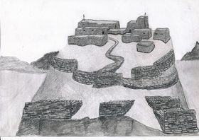
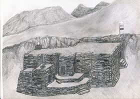
In this residential type are all habitational structures located on the summits and prominences of mountains, ridges, hills, and high rock formations. By the very nature of these geographic locations, such monuments have an inherent defensive aspect to a lesser or greater extent. Among this residential type are edifices that functioned as fortresses and citadels (habitations designed and built for military purposes), temples and hermitages (buildings with a religious or ceremonial function), palaces (social elite residential buildings), and breastworks (networks of ramparts or other types of defensive structures that were temporarily or permanently inhabited). It must be noted that, from a visual appraisal alone, the specific occupational functions of individual edifices or components thereof can only be inferred. In any event, these strongholds, temples, palaces, and hermitages appear to have been where the ruling and priestly classes exercised their social influence and political control over the agriculturalist and pastoralist sectors of society.
I.1a) All-stone corbelled buildings
This building subtype represents one of the most prominent classes of residential structures found in Upper Tibet. In the parlance of the region, this style of architecture is often referred to as dokhang (all-stone habitation). This form of construction is characteristic of the archaic cultural milieu of the region, and is eminently well suited to the environmental exigencies of the harsh landscape. It is in Upper Tibet that all-stone corbelled buildings reached their fullest architectural expression in all of Central Asia. This building design is exceptionally rugged and structurally stable, and individual examples may, in some cases, have endured as habitations for centuries.
All-stone structures feature the use of corbels, stone members that were placed on the upper extent of walls as load bearing devices for the stone roof assembly. Corbels were simply rested on the tops of walls or were inserted into specially built wall sockets. Corbels act to support bridging stones and stone sheathing from which the roof was made. Bridging stones were laid diagonally or crosswise in one or more courses over the corbels in order to span the distance between opposite walls. In turn, large slabs of stones were placed upon the bridging stones to create a complete roof covering. The elementary corbelling technique employed in Upper Tibet for roofs was only suited for use over small interior spaces (typically 3 m² to 12 m²). Large edifices were created by juxtaposing multiple, structurally self-contained rooms or groups of rooms together to form a contiguous ground plan. In some places (such as sites A-10 and A-54) corbels with sockets were used to support the stone flooring of a second story in the same fashion as roofs were constructed.
All-stone corbelled edifices have many unique design traits. In general, they are massively built, a consequence of the great weight that the roofs bear on these structures. Walls are between 60 cm and 1.2 m in thickness, and of a slab or block random-rubble texture. Both dry-mortar and clay-mortar seams are represented in their construction. Roofs are, as a matter of course, flat and originally must have been layered in gravel and clay to weather-proof the buildings (little evidence of this more ephemeral aspect of construction has survived). As each room or group of rooms is an isolated unit structurally, the exterior walls of such structures have an irregular or even a meandering plan. Walls are of variable thickness, with various exterior indentations and interior recesses common. Both exterior and interior corners tend to have a rounded quality, as this facilitates the arrangement of corbels. Interior walls are punctuated with buttresses that function to support intervening series of corbels and roof appurtenances, especially in larger rooms. The floor-to-ceiling height of rooms in dokhang is usually relatively low (1.6 m to 2 m). Most buildings are windowless and even in certain structures where there are interior and exterior window openings, these are small in size.
Single buildings contain between two and one dozen rooms, which are normally arranged in rows or isolated aggregations. Rooms directly open onto one another or are connected through a small corridor or interclose. Various wings in a single building usually had separate exterior entrances, as large interconnecting halls and galleries are not possible in dokhang construction. Another defining feature of the all-stone corbelled edifices is the very small size of their doorways; these average only around 1.1 m in height. The lintels of the entranceways (and the few windows) are made from stone. The heavy windowless walls and low doorways of the rooms indicate that they must have been weatherproof and easy to heat. Collections of small rooms also indicate that a decentralized or compartmentalized domestic ecology was the norm. Individual cells must have been set aside for the various facets of everyday life such as sleeping, food preparation, storage of provisions, and religious observances. Rooms were only large enough for individuals or small family units. Cooking, meetings and ceremonial life inside the dokhang could only have revolved around small groupings of people.
Customarily, sundry dokhang on a summit were vertically interconnected to create a staggered array of structures. Naturally occurring rock outcrops and ledges were commonly used to help support corbelled buildings and to act as one or more walls of the structure (particularly in the rear). This form of construction is very favorable to incorporation into the adjoining terrain, as walls could be built to accommodate the twists and turns of rock faces. This high degree of integration with the parent formation is a distinguishing feature of dokhang design. Although corbelled edifices individually have low architectural elevations (there are no high ceilings in rooms, and parapet walls where they exist appear to have been minimal), the stacking of one on top of another has the effect of producing formidable complexes. It is not uncommon to find these clinging to the sheer walls of a summit for many vertical meters. In sites that appear to have functioned as hermitages, individual residences tend to be separated from one another rather than forming aggregated complexes. The use of prominent revetments, a common feature, significantly increased the elevation of exterior faces. Revetments function to give buildings a stable foundation and to even out the dips and rises on rocky summits. Rather infrequently, all-stone edifices were integrated with other building types at a single site. Occasionally, there is also evidence to suggest that the basement or lower story of a building was fashioned as a dokhang, while the superstructure was of an alternative style of construction (see site A-51).
The wide distribution of dokhang through most areas of Upper Tibet and their superb adaptive bearing indicates that they were a chief residential type for a long period of time in the region. Bronze Age occurrences of corbelled edifices in regions like the British Isles and Mediterranean may suggest that this form of architecture developed in Upper Tibet at a relatively early date. The lack of demonstrable monumental precedents in the archaeological record of Upper Tibet reinforces the impression that all-stone edifices have a very long legacy behind them. Chronometric data on the sites surveyed are now undergoing compilation; these results furnish the best archaeological evidence corroborating the archaic nature of Upper Tibet’s all-stone edifices.1
I.1b) Edifices built with timbers
This heterogeneous monument subtype includes all residential structures that were built with roofs containing timbers. Among the examples included in this inventory may be sites that were actually founded or redeveloped after the early historic period that could not be differentiated from older strongholds (because of the possession of similar morphological and cultural attributions). Further archaeological investigation will be required to clear up this typological ambiguity. Edifices constructed with wooden roofs located on summits generally have a good defensive posture. As with the all-stone corbelled structures, their domiciliary usage appears to have varied greatly. Citadels, fortified settlements, temples, and palaces are all probably represented among this class of habitation. These timbered edifices are of four major wall fabrics:
- Random-rubble and coursed rubble stone walls
- Adobe or unbaked mud block walls (sapak)
- Rammed-earth or shuttered walls (gyang)
- Walls of cut earthen slabs
i) Residential structures built with stone walls are commonly encountered throughout Upper Tibet. Where walls are left standing, this type of construction is readily identifiable: walls are straight and regular and can be of considerable length. As roofs were built with wooden timbers, the walls supporting them were not required to be as massive as structures with much heavier all-stone roofs. The regular buttressing and indentations of dokhang walls is also conspicuously absent. Moreover, high elevation profiles and large rooms and halls are found with much frequency, especially among Buddhist complexes. However, what appear to be archaic structures built in this manner share some of the customary features of dokhang design. These include edifices with smaller rooms, windowless walls, relatively low entranceways, adeptly constructed random-rubble slab walls, a high degree of topographical integration into the parent formation, the proliferation of small buildings staggered vertically across a summit, and series of small ramparts.
None of the stone wall buildings surveyed have their roofs intact but the general constructional pattern and the rare presence of timber fragments suggests that roofs were constructed much as they were in the Central Tibetan style of architecture. This entails the laying of timbers across the top of walls and covering them with wooden and/or stone interlinking materials. Once the roof was completed in this fashion, wattle, clay and possibly Tibetan cement (arka) must have been used to build successive enclosing layers. Unlike the traditional architectural landscape of Central Tibet and Eastern Tibet, there is no evidence of towers having been erected in Upper Tibet, stone buildings of more than two stories being rare in the region.
A site attributed to the ancient Mön in the oral traditions of Upper Tibet Kapren Gyanggok (A-33) was in use as late as the 13th century CE. Chronometric data obtained from Kapren Gyanggok reinforces the view that monuments attributed to the Mön must be understood in a broad historical and cultural framework.
ii) Residential structures built with adobe blocks are commonly encountered in Gugé, that large Transhimalayan badlands region in the Sutlej (Langchen Tsangpo) drainage area of deep gorges and highly eroded earthen formations. While mud-brick walls are common in Buddhist era buildings (such as monasteries and retreats) in the Jangtang, there is scant evidence that such structures were established in pre-Buddhist times. One exception may be a complex of buildings at Drakgam Dzong (B-40). It was founded on a slope overlooking the Mukyu Tsangpo basin, a rich pastureland.
Adobe block edifices were founded in great numbers in Gugé in the Buddhist era. According to the local oral tradition, they were established in the prehistoric epoch and had been the handiwork of that elusive tribe the Mön or Kel Mön/Kel Mön.2 From an environmental perspective, this claim of antiquity for elementary earthen structures is plausible, for building stones are in short supply in many corners of Gugé, and lithic materials appropriate for corbelling and bridging only very seldom occur. The antiquity of adobe block constructions is also supported by recently compiled chronometric data from the Rula Khar site (A-141) (see below). Systematic survey of sites in Gugé, to which oral tradition assigns an archaic identity, has brought to light physical evidence, which tentatively permits adobe structures to be chronologically differentiated from one another. One distinguishing criterion employed in trying to determine what may be examples of archaic adobe edifices is based on an analysis of building design. Sites such as Hala Khar (West) (A-58) strongly contrasts with known Buddhist architecture of the region. Its highly exposed and isolated aspect, unusual ground plan and extremely deteriorated condition are circumstantial evidence for the inclusion of Hala Khar (West) in the category of archaic monuments. This single 32 m long contiguous complex consists of four rows of tiny rooms that run parallel to the axis of the summit at different levels. No Buddhist monuments or emblems are found at Hala Khar (West) and no Buddhist religious lore is attached to the site.
The survey of citadels and other summit residential structures attributed to the ancient Mön in the localized traditions of Gugé demonstrates that most of the facilities exhibiting mud brick wall construction are in fact primarily built of stone. At most so-called Mön sites adobe walls were used for relatively minor constructions and for upper wall courses. What adobe walls do exist are as a rule much more highly eroded than Buddhist constructions. At none of theMön castles (möngyi khar) are there large, high-walled buildings (lhakhang, dükhang, etc.) like those found at virtually every Buddhist monastery in Gugé. Moreover, sites attributed to the archaic period of construction are often associated with troglodytic communities with few or no signs of Buddhist occupation. A foundation or refurbishment date of circa 565 to 705 CE is indicated for the adobe block northwest edifice of Rula Khar (A-141). The relative position of the radiocarbon assayed sample in the building confirms that adobe block constructions were indeed part of the archaic architectural canon of Gugé.
iii) Rammed-earth residential structures that local oral tradition places in the archaic period are limited in geographic range to lower elevation western Ngari Korsum and in particular, to Gugé. A single wall of this construction type attributed in the oral tradition to the Zhangzhung kingdom is found at the high point of the Takla Khar fortress (A-81) in Purang. In Gugé, summit strongholds such as Jangtang Khar (A-116) and Sharlang Khar (A-118), two castles that in the local oral traditions are assigned to the Kel Mön, have rammed-earth structural remnants. Walls of this type, nevertheless, are found at only a minority of strongholds attributed to the ancient Mön in Gugé. The technological origin and chronology of rammed-earth walls, built by packing wet earth and clay with a stone matrix between large wooden shutters, is not at all certain. It may be that rammed-earth structures are wrongly attributed in legend to the archaic period or that they were founded at sites with structural remains from earlier periods of occupation.
iv) At just a few fortified sites in Gugé another type of wall was formed from naturally occurring compressed slabs of earth, which were cut from the native formations. Structures built with this type of wall dominate at Cholo Puk (A-113) and Rakkhashak Möngyi Khar (A-115), strongholds attributed by local residents to the Mön. At Cholo Puk, a sequence of chambers were cut out of the long flat summit, and the slabs resulting from the excavation used to build walls above the top of the excavated chambers. Parapet walls were also built around the edges of the summit using the same natural earthen slabs. The absence of monuments indicative of Buddhist occupation at these sites, as well as their semi-subterranean aspect, encourages the view that earth slab fortifications do indeed date to the era of archaic residential structures.
I.1c) Solitary rampart networks
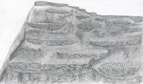
Some strongholds in Upper Tibet are exclusively composed of networks of defensive walls traversing summits and adjoining slopes. At sites such as Namdzong (A-48) and Takzig Nordzong (A-50) there appear to be few, if any, residential buildings, but rather a series of ramparts fortifying a strategic mount or rock formation (those in proximity to a high quality pasture or important pass). These random-rubble dry-mortar breastworks consist of long walls that wind across slopes vulnerable to attack. Typically, the walls are 1 m to 2 m high on the downhill slope, and slightly elevated or flush with the uphill side of a slope. These defensive structures are normally around 1 m to 2 m in width, and between 2 m and over 100 m in length. Parapet walls or ledges were probably built on the outward projecting edge of the ramparts but much of the structural evidence for these features has disappeared down the slopes with time. A chief characteristic of rampart network design and deployment is that they appear in multiples, each wall running in a transverse direction at different elevations and somewhat parallel to one another. An approachable slope may have upwards of eight successive ramparts, one above the other, guarding the higher and more vital reaches of a site. In addition to being aligned in parallel, defensive walls join one another or branch out in different directions across ribs of rock and broad acclivities. Some of the wider, more level and sheltered breastworks appear to have functioned as platforms for camps and the garrisoning of fighters. The intricate arrangement of breastworks as the exclusive or dominant architectural component of a fortified site bespeaks a special form of defensive posturing by which entire rock formations functioned as strongholds.
While some sites seem to have been comprised entirely of breastworks, most of the archaic fortifications of Upper Tibet heavily relied on them for defense. At many citadels, defensive walls form an integral part of the complex. These are of three major types: 1) those staggered below residential structures that are erected on a summit; 2) those that encircle the main nucleus of habitation (circumvallations); and 3) those that connect various residential structures (curtain-walls).
- ^ On the basis of similarities in size, orientation and ground plan, as well as the presence of an interior pillar marking an analogous area in the Dindun site (Dingdum) habitation S4, Mark Aldenderfer infers that the ‘Founder’s House dokhang’ (part of site B-13) may date to the same period, circa 550-100 BC (Mark Aldenderfer, “A New Class of Standing Stone from the Tibetan Plateau,” The Tibet Journal 28, nos. 1-2 [2003]: 3-20). A small round of wood was discovered in the stone rubble of a semi-subterranean dokhang at the Gekhö Khar lung site (A-89). This specimen has yielded a calibrated radiocarbon date of circa 200 BC to 100 CE. The historical persistence of dokhang as active residences until the early second millennium CE, is indicated in the contest between Buddhist yogin Milarepa and the Bön adept Naro Bönchung (Bellezza, Antiquities of Upper Tibet, 65).
- ^ An important textual reference concerning the historical identity of the Kel Mön of Upper Tibet is found in Mar lung pa rnam thar, written by Thon kun dga’ rin chen and Byang chub ’bum (13th century CE). For this reference, a translation, and bibliographic information about the text, see Roberto Vitali, The Kingdoms of Gu.ge Pu.hrang. According to mNga’.ris rgyal.rabs by Gu ge mkhan.chen Ngag.dbang grags.pa (Dharamsala: Tho.ling gtsug.lag.khang lo.gcig.stong ’khor.ba’i rjes.dran.mdzad sgo’i go.sgrig tshogs.chung. 1996), 200 (n. 287), 589. It must be noted that Vitali’s translation of the passage under question differs in a number of important areas from the one I provide below. Vitali maintains that the concerned passage documents a group of northerners distinct from the Kel and Mön, for which there is little grammatical basis. In his excellent study, Vitali may have been persuaded to translate the passage in such a way because of various other historical references that place the Kel Mön in Himalayan regions. The Mar lung pa rnam thar records that the Mön and another group known as the Kel were pushed out of northern areas of Tibet by the Hor (probably a Central Asian Turco-Mongolian group), forcing them to settle further south (in Gugé?). According to Vitali’s analysis, this event occurred between the demise of the Tibetan empire and the founding of the Ngari Korsum kingdom by Nyima Gön, in the early tenth century CE (Vitali, Kingdoms of Gu.ge Pu.hrang). Evidently, in their new homeland the Kel and Mön, Bön practitioners, became amalgamated into one tribal entity. This account provides a historical basis for the pervasive Upper Tibetan oral tradition, which holds that the Jangtang was once widely populated by the Kel Mön. This Mar lung pa rnam thar account also documents the creation of a castle by the Kel Mön, but unfortunately it is not referred to by name or location. The text reads as follows: “…The four mountains of Kel [and] the thirteen tongdé (divisions of 1000) of Mön were the people of the north. They were driven out of their country by the Hor and arrived in the southern districts. They settled in different places. They built a great castle. The Kel Mön king Yukha received empowerments and transmissions (these teachings were received from Tönmi Nyima Özer, a Zhang Zhung Nyengyü master who was alive in the late ninth century CE). He produced a Bön Kham Chen (a sixteen-volume collection analogous to the Buddhist yum) in gold lettering” (skal gyi ri bo bzhi/ mon stong sde bcu gsum/ byang gi mi yin pa hor gyis yul ston lho ru sleb/ yul so so btab/ mkhar chen po rtsigs/ skal mon gyi rgyal po g.yu khas dbang lung zhus/ bon khams chen gser ma zhengs/; Vitali, Kingdoms of Gu.ge Pu.hrang,200, 222).
This type of residential site includes all monuments situated in any geographic locality other than those set on top of summits. Such habitations are found on broad slopes (those with higher ground in the immediate area), valley bottoms, ravines, gorges, benches, esplanades, headlands, and at the foot of or in escarpments and outcrops. However, such sites are seldom found in the midst of large exposed plains. The same kind of constructional and design elements exhibited by the summit residences are part of this category of archaic sites. The majority of them appear to have been habitations for religious and other high social status forms of residency. We might expect that, when most of the population of the Jangtang was housed in black yak hair tents (dranak) and other types of temporary shelters, the occupation of highly weatherproof permanent habitations was a mark of social distinction and achievement. This, indeed, was the state of affairs in the pre-modern Jangtang. Cave residences are found throughout Upper Tibet, but in numbers that would not have permitted more than a small fraction of the total population to avail themselves of such facilities in any given period (with the notable exception of Gugé with its many thousands of caves).
I.2a) All-stone corbelled buildings
These edifices are of the same design and construction as those perched on summits, the main difference between them being situational in nature. As such, all-stone corbelled buildings or dokhang located away from high ground lack a strong defensive aspect. Functional differences in the kinds of occupancy may be implied by these locational contrasts. All-stone edifices removed from summits tend to be individual dwellings separated from one another by meters or tens of meters of distance. This contrasts with the clustered plan of many summit sites.
There are differences in design that arose in accordance with varying physical settings. Dokhang in lower, more open areas often have walled courtyards on their forward (usually east or south) side. These domestic spaces, enclosed by random-rubble dry-mortar walls, must have been used for chores, social functions and other activities appropriate to the outdoor environment. Another difference is that these less defensible dokhang frequently have a semi-subterranean aspect. Typically, the rear or uphill slope walls were set deeply into the ground, sometimes so much so that the roof was nearly flush with the slope. In areas where there was an adjacent cliff or rock face, one or more walls of the structure were set partially or entirely below it. Clearly, this saved on the amount of building materials but there are likely abstract cultural factors at play as well. Rear walls of the all-stone corbelled buildings frequently have niches and recesses built into them, adding to the underworld atmosphere of the structures. These subterranean compartments may have had a ritual function such as that connected to the propitiation of chthonic deities.
I.2b) Other free-standing building types
This subtype includes all habitations built with wooden roofs not located on summits. Many of these structures appear to have supported timber roofs. Potentially, sites that had semi-permanent roofing materials such as yak hair cloth or hardened yak hide are also among this category of edifices. The constructional characteristics of sites like Lung Ngak (B-80) and Dechö Kelmön Yül (B-81) are difficult to judge. Their wall design, building dimensions and alignments appear to have supported less substantial semi-permanent roofing materials. A building with a wooden roof situated in the middle of open ground that can be attributed to an early period is Bumo Lhakhang (B-87), a highly unusual adobe block edifice. Among the sites of an indeterminate subtype are those that appear to be the vestiges of sizable villages, which were seated on wide benches or gentle slopes. These are usually so deteriorated that only zones of rocky depressions and mounds exist where there were ostensibly once domiciles (see B-71, B-85).
I.2c) Buildings integrating caves and escarpments in their construction
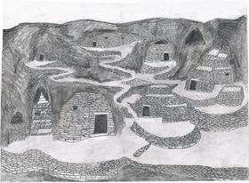
This building subtype is also defined according to geographic placement. It includes all residential structures that were set in or around caves, rock overhangs and fissures. Caves, especially when accompanied by freestanding residential structures, provided one of the most secure and hospitable living environments in the archaic cultural horizon, as they have in more recent times. Most Lamaist era cave habitations were the domain of religious practitioners, but in archaic times it appears likely that a wider spectrum of society was housed in this fashion. Local legends indicate that such sites constituted the original nexus of settlement in numerous locales. This is borne out by the existence of high quality springs at some sites, in stark contrast to the surrounding, often waterless plains. The formative historical nature of cave settlement appears to be particularly the case in the Transhimalayan Gugé region.
In the Jangtang most caves are ensconced in limestone formations. The most common architectural feature in this category of construction is the façade wall, a barrier that served as the front for caves. Stone and mud bays, altars, shelving and platforms are sometimes found inside the caves. In Gugé, where most of the caves were hewn from earth and gravel formations, arched recesses and niches are characteristic internal features. Multi-room and even multi-story edifices were also established within the embrace of caves and rock shelters. These structures possessed both all-stone corbelled roofs (see B-107) and roofs with wooden beams and wattle (see B-110). In addition to dwellings, sanctuaries and temples were sometimes located in larger caverns (see B-108, B-119). These sites have internal structural features such as ceremonial platforms, partition walls, shrines, and even pictographs (see B-118, B-119).
This division of monuments includes all types of archaic archaeological sites that had a non-habitational ritual or symbolic function. Included within this division are various types of pillars, some of which are associated with superficial constructions of different kinds (most are funerary superstructures). Other pillar complexes boast above-ground tombs and reliquaries. A variety of smaller shrines and tabernacles are also part of the ceremonial division of Upper Tibetan monuments.
One of the most captivating types of archaic archaeological site in Upper Tibet consists of stelae, pillars or menhirs either in a solitary aspect or in groups forming special kinds of arrays. In this work, descriptions of 110 sites featuring pillars are presented. The Tibetan generic term doring is applied to pillars of all species in Upper Tibet. These standing stones vary greatly in size (15 cm to 2.4 m in height) number and layout, which is indicative of a fairly broad variety of ritual applications and cultural contexts. As with the dokhang residential monument, pillars without inscriptions reached their highest level of development on the plateau in Upper Tibet. Pillars exhibiting different morphological characteristics were erected hewn or unhewn, and were made from a diverse assortment of rocks (including igneous, volcanic, metamorphic, and sedimentary). Pillars, whatever their function, were planted firmly in the ground by first excavating a hole to accommodate 30% to 50% of the total length of the stone. Over the centuries, through the agency of gravity and geomorphologic change, it is common for pillars to have collapsed or to tilt in a downhill direction. Gently and even radically inclined pillars are encountered at many sites. Pillars in the Upper Tibetan archaic archaeological context appear to have functioned as political monuments for clans and chieftains, cultic sites for the worship of deities, good fortune enhancement and harm reduction instruments, and as memorials and ritual dispensation sites marking cemeteries.
II.1a) Isolated pillars
Pillars that stand alone or in groups (two to twenty in number) in isolation from other structures are commonly distributed in the Jangtang west of 90° 45΄ E. longitude. Lone pillars are also found in a few locations in Gugé and Purang. The function, significance and chronology of pillars that stand alone, without the benefit of other structures that can serve as interpretive benchmarks, are very difficult to assess. It appears that some pillars, grouped in rows, heralded the existence of cemeteries. Lines of pillars that probably mark grave sites are found in places like Gyaplung Doring (C-13) Doring Gyaplung (C-23) and Dzatsok Doring (C-28). There are probably other examples among the pillar sites recorded where physical evidence of the tombs has been effaced from view. Individual pillars are also known from certain grave sites (see D-72). Solitary pillars, especially those in Gugé, appear to have had a cult function pertaining to the worship of local deities (see C-14, C-169, etc.). Some of these stelae are still used in the placation of indigenous spirits at annual community rites (such as the lhasöl, held during sowing and harvesting). Other solitary pillars could have been erected as territorial markers; such is the local oral tradition surrounding Chunkhor Doring (C-25). Finally, it is also plausible that some of what now appear to be isolated groups of stelae were in fact erected inside quadrate stone enclosures, the signs of which have been obliterated.
II.1b) Pillars erected within quadrate enclosures
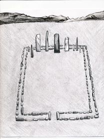
Pillars erected within square or rectangular walled enclosures represent one of the most distinctive types of archaic ceremonial monuments in Upper Tibet. Due to their unique morphological characteristics and territorial specificity, they serve to delineate the paleocultural domain of the region. Pillars erected within a quadrate enclosure were most often built in open areas such as plains, large benches or wide slopes endowed with long vistas to the east. They are customarily founded on well-drained level or very slightly sloping gravelly or sandy terrain, with a ridge or hill serving as a western backdrop. Some sites overlook lakes, rivers and marshes, while others are found in waterless areas. One or more pillars are invariably set on the west side of a stone enclosure, in close proximity to the inside edges of the bordering walls. In most cases, the enclosures are generally aligned in the cardinal directions and less frequently, in the intermediate directions. One to more than a dozen pillars was planted inside a single enclosure. Pillars vary significantly in shape and size. They can be tabular, four-sided, three-sided, or irregularly-shaped, and range in height from 20 cm to 2.4 m. Tabular pillars usually have their two broad sides oriented north-south. They have both flattened and pointed tops. Some pillars were carefully cut into regular shapes, while at most sites, raw stones were used for installation. Pillars erected inside a quadrate enclosure were constructed from a wide variety of locally occurring lithic materials, and it is not uncommon for more than one type of rock to have been used in construction, creating structural elements of contrasting colors and textures.
At some locations, one or more walls of the enclosures are raised above the surrounding terrain in order to maintain a level interior. Rectangular enclosures regularly have longer dimensions east to west. An exception is encountered in certain rectangular enclosures in far western Tibet, which have longer north to south dimensions. This constitutes a regional design variation with no other significant morphological differences observed. The enclosures vary in size between 3 m by 3 m and 14 m by 22 m. The walls forming the perimeter of the enclosure normally contain parallel courses of stones, and range between 40 cm and 80 cm in thickness. Most enclosures are constructed of unhewn upright stone slabs or blocks (10 cm to 80 cm in length), which are embedded in the ground. These stones are level with the ground surface or are elevated above it to a height of 10 cm to 40 cm. However, some enclosure walls are composed of two to four vertical layers of blocks and may be as much as 50 cm in height. It is not uncommon to find both superficial and built-up wall sections in a single enclosure. In some examples of the enclosure, there is an opening in the middle of the east wall, which appears to have functioned as an aperture of ritual importance.
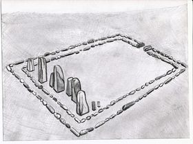
Most commonly, there is just one walled pillar monument per site but at some places there are two, which are spaced 10 m to 1 km apart. In more recent times, a significant minority of the pillar sites was used in apotropaic and fortune-bestowing rituals associated with the indigenous pantheon. Pillars erected inside quadrate enclosures are frequently found in proximity to other funerary structures such as slab wall arrays, burial tumuli and other types of tomb and funerary ritual superstructures. Funerary structures are discernable at more than one third the total number of walled pillar sites surveyed. It seems likely that most of these pillar monuments originally accompanied some form of burial, the signs of which are not necessarily visible on the ground surface. It does not appear, however, that the pillars were raised directly on top of tombs.
Pillars erected within quadrate stone enclosures appear to have functioned as memorials or commemorative monuments for the deceased, who were buried in outlying tombs. Special rites may have taken place inside the enclosures such as the depositing of offerings and the lighting of sacrificial fires. Archaeological investigations show that analogous enclosures of the Scytho-Siberians and Turks were used for such purposes. The erection of pillars may have acted as a symbol of temporal power, linking the tribal leadership with their ancestral rulers and deities.1 A localized clan or cultic function connected to the levers of social and political power is suggested by the solid distribution of the monument throughout its territorial scope.2 Dunhuang and Bön funerary accounts suggest that the erection of pillars occurred in rites designed to lure the souls of the deceased to the center of ritual operations, so that they could be sent on to the ancestral afterlife. The funerary pillars of the Bön literary tradition are known as ‘receptacles of the soul’ (layi ten).
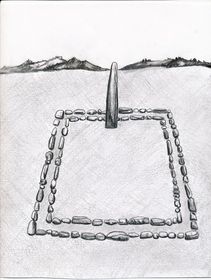
Pillars erected within enclosures or in isolated rows occur in the north Inner Asian funerary archaeological record as well. The morphological, functional and geographic aspects of the late Bronze Age and Iron Age pillar monuments of the steppes indicate that they have significant cultural and ecological affinities to the Upper Tibetan pillars erected in quadrate enclosures. These interrelationships are examined in Zhang Zhung: Foundations of Civilization in Tibet. Linkages as cognate ideational, technological and environmental innovations suggest the kind of time frame in which the Upper Tibetan pillar monuments originated and developed. Nevertheless, the doring of Upper Tibet represent unique conceptions of design, spatial ordering and ritual practice, which are indicative of a cultural entity distinct from its northern neighbors. Cross-cultural archaeological comparisons with the Scytho-Siberians encourage the view that the walled pillars sprang up in Upper Tibet as early as the beginning of the first millennium BCE. Unlike the tumultuous steppes with their great clashes of peoples and the attendant disintegration of cultures, the pillars of Upper Tibet seem to have survived as a relict cultural form perhaps through the imperial period. The geographic isolation of Upper Tibet from the epochal human movements of north Inner Asia, and what appear to have been its relatively stable economic and cultural systems, argue in favor of the long-term persistence of the monument.

Pillars erected inside quadrate enclosures are well distributed throughout Upper Tibet, west of 89º 26΄ E. longitude and south of 33º 30΄ N. latitude, with the exception of Transhimalayan Gugé. The geographic bounds of this pillar subtype correspond to what we might call the ‘core area’ of Upper Tibetan archaic cultural entity. The absence of these emblematic monumental features in the far eastern Jangtang (or in any other region of the Tibetan Plateau) indicates that these regions had different cultural and/or ethnical compositions. As the pillars erected in quadrate enclosures possess definitive design and constructional features, setting them apart from the archaeological monuments of adjoining regions, they are admirably suited to serve as territorial markers delineating the heart of the Upper Tibet paleocultural zone. It would appear, based on the monument’s areal distribution, that this unique Upper Tibetan ecological and cultural domain is tantamount to the prehistoric and early historic Zhang Zhung cultural sphere of the Tibetan textual tradition.3
II.1c) Quadrate arrays of pillars with appended edifices

Vertically set stones, erected in rows aligned in the cardinal directions to produce large formations of pillars, share the same geographic scope as the pillars erected inside enclosures. These pillar arrays were also usually constructed on level or slightly inclined ground with deep vistas to the east. They are found on the edges of plains or on broad esplanades, often bounded in the west by a ridge or mountain slope. In most instances, fields of standing stones appear to have been established in areas remote from human settlement, for many of the sites are devoid of permanent sources of potable water. In a single complex, there were between several hundred and 3000 pillars set into the ground in more or less evenly distributed rows. Considerable attention was devoted to insuring the orientation of the pillars and the integrity of the grid pattern.
The concourses of stelae vary greatly in size, and cover between 30 m² and 4000 m². The stelae range in height from 15 cm to 1.4 m, with an average protrusion above the ground of around 40 cm. These pillars were made from either natural pieces of stone or perhaps from rocks that were roughly cut into shape. The smaller specimens tend to be pointed. Many of the larger stelae are tabular in form and have their broad sides aligned in a north-south direction. They are made from a variety of stones, depending on the geological makeup of the locale. The rows of standing stones are positioned 40 cm to 1.2 m from each other, as are the individual stones that make up a row. At some sites, slabs of stone (10 cm to 1.2 m in length) were embedded in the ground edgewise, often in parallel courses, around the array of standing stones. The same slab walls are sometime used to subdivide the concourse of pillars into smaller units. These 20 cm to 40 cm thick slab walls are flush with the surface or protrude above it to a maximum height of 20 cm. There are also numerous instances of double-course slab walls, extending 3 m to 30 m east of the pillar arrays, to create an extensive grid of parallel structures which are also aligned in the cardinal directions.
One to six meters west of an array of pillars is what appears to have been a mortuary temple cum tomb edifice. The lines of pillars seem to have almost reached the tomb but, at many sites, proximate rows have been uprooted. Like the pillars themselves, these masonry structures are usually aligned in the cardinal directions. They vary greatly in size and complexity, ranging between 3 m to 65 m in length. The tallest surviving temple-tombs are 4.3 m (Yül Khambu, C-143) and 3.5 m (Shasha Pelkhang, C-145) in height, but originally they may have been substantially taller. Although none of the top-most part of these structures has endured, they were almost certainly built with flat roofs, probably of an all-stone corbelled composition. In the larger edifices, the windowless walls are up to 2.5 m in thickness, creating relatively small, hermetically sealed, interior spaces. This clearly indicates that these structures were not built for habitation. Where significant elevations have survived, it can be discerned that most were four-sided structures, the larger of which were divided into two to five or more compartments. It appears that these robustly built internal spaces were burial or reliquary chambers. Taller walls of the temple-tombs slightly taper inwards in the Tibetan ‘fortress’ style of construction, a design feature not well articulated in other Upper Tibet archaic monument types. Walls were constructed of coursed-rubble of variable-sized stone blocks and slabs whose exterior faces were hewn smooth. Masonry courses were laid flat, as well as in a distinctive ‘herringbone’ pattern, whereby two intervening courses were set diagonally into the wall. To reinforce larger walls, courses of thin bond stones were also employed at strategic levels. The interior walls appear to have been built of finer masonry than the exterior walls. Small quartz crystals and pieces of red sandstone are found scattered at some sites; these may have been employed as decorative or ritual elements.
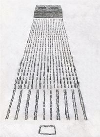
In the local oral tradition, the monolithic arrays and accompanying mausolean tombs are often accorded a funerary function associated with the ancient Mön tribe. Local reports hold that human skeletal remains were discovered at certain sites, indicating that they did indeed function as necropoli. Other types of tomb superstructures and pillars are quite often found in close proximity to the pillar complexes, corroborating this view. It would appear that the edifices appended to the pillars functioned as tombs and as temples where mortuary and perhaps commemorative rites were conducted for the interred. The ritual function of the fields of standing stones is a mystery. There is some speculation among local residents that each pillar represented a single individual, as in the constituent members of an ancient army. Some drokpa believe that under each pillar are the remains of an individual. Such an impression emphasizes the corporate or community-based aspects of the monument as important centers of ritual dispensation and social interaction. The pillars may have ritually functioned to capture the souls of the deceased before their send-off to the afterlife. This old Tibetan funerary culture motif would seem particularly relevant if the quadrate arrays of pillars with appended edifices were founded to honor those fallen in battle. According to the Bön archaic funerary texts, those who die from violent causes (driwo) require elaborate apotropaic and fortune-bestowing rites to be carried out in order to commend the soul to the ancestral paradise. Markers (to), probably represented by stone cairns or pillars in some cases, are recorded in these funerary texts as being essential in pressing down (nönpa) potentially harmful chthonic spirits such as the lu and si. This kind of rite was carried out by priests known as durshen and dri bönpo.
The effort made to align the edifices and networks of pillars in the cardinal or intermediate directions is in itself highly significant. I am inclined to see this orientation as reflecting important religious preoccupations pertaining to the celestial sphere. Solar, lunar and/or sidereal alignments and calendrical parameters may have been incumbent in the spatial bearing of the structures. According to Bön ritual literature, many of the deities of Zhang Zhung were associated with celestial and meteorological phenomena, and similar religious traditions may also be implicit in the careful alignment of the pillars and edifices.
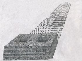
The relative scarcity of arrays of pillars appended to temple-tombs (the obliteration of specimens notwithstanding) and the highly elaborate nature of their construction allude to an exclusive social sphere. It seems most likely that these necropoli are where the elite of society (the regional priestly and/or ruling classes) carried out ritual functions for those of similar rank, and where they were ultimately inhumed. Such cultural activities are likely to have been conducted with the large-scale cooperation and participation of local communities. The existence of great complexes scattered across Upper Tibet from 89° 26΄ E. longitude west to the southeastern extent of Gugé (80° 47΄) may also indicate that there were multiple geographic centers of political power. A dispersed dominion is supported by the legends of the Zhang Zhung kings occupying various residences across much of Upper Tibet.4 Such archaeological and textual evidence buttresses the widely circulating hypothesis that Zhang Zhung was a tribal confederacy or decentralized state, where political power was largely in the hands of the constituent regions and/or clan factions.
The extensive use of pillars in Inner Asia is first attested in south Siberian Okunev burial sites (middle of second millennium BCE). Standing stones associated with burial sites are also prevalent at pre-Scythian (1200 BCE to 800 BCE) and Scytho-Siberian sites (800 to 300 BCE) in north Inner Asia. These pillars were erected in close proximity to funerary ritual enclosures, burial mounds and other types of mortuary structures. At southern Siberian Tashtyk sites (first to sixth century CE) one or even several rows of pillars with broad sides directed north and south are a common funerary architectural feature. Prolific use of standing stones is found at early Turkic burial sites (sixth to eighth century CE) of Mongolia, Tuva, the Altai, Kirgizia, Kazakistan and Xinjiang. These so-called bulbul stones can number up to 157 in a single row and are usually planted on the east side of slab wall enclosures (used for ritual or cremation purposes at early Turk burial grounds). The bulbul stones are 10 cm to 70 cm in height and spaced 50 cm to 5 m apart.5 As the pillar arrays of Upper Tibet share general technological, morphological and ritual traits with those found in the steppes, it suggests that certain religious conceptions pertaining to death diffused between the regions as part of a pan-cultural heritage.6 My findings indicate that Bronze Age ethnical commonalities, as well as the widespread development of nomadic pastoralism and the riding horse in the first millennium BCE, are likely to account for the fusion of certain abstract cultural elements in the steppes and Upper Tibet.
Clearly, however, the pillar arrays of Upper Tibet represent a unique form of funerary monument that developed and flourished only in this region. Nowhere else in Inner Asia did such large numbers of orderly arranged stelae arise at a single site. Moreover, the above-ground massively built mortuary temple-tombs of the Upper Tibetan context represent a remarkable cultural achievement, reflecting a good deal of indigenous technological and cultural sophistication. Foot bones extracted from a grave cleaved in two by a seasonal torrent at Khangmar Dzashak (C-160) have yielded a conventional radiocarbon age of 740 BCE +/- 40 years. This chronometric evidence indicates that such sites were established as funerary complexes by the first third of the first millennium BCE. The incorporation of the dated tomb between two pillar complexes at Khangmar Dzashak encourages us to view the stelae and appended temple-tombs as an integral part of the same spectrum of funerary traditions. As for the demise of this monument type: it seems unlikely that after Pugyel Tibet’s annexation of Zhang Zhung in the seventh century CE, such large displays of indigenous power and prestige would have been tolerated or even economically feasible. In any event, with the coming of Buddhist domination at the turn of the second millennium CE, the use of the arrays of pillars and temple-tombs must have been completely discontinued.
II.1d) Domestic Pillars
In 1998, a pillar was found erected in a still standing all-stone habitation at Dodrilbu (B-13). This 65 cm high pillar is found fixed in the small western-most room of this dokhang, which has much of its roof still intact.7 With the discovery of a second pillar in the poorly preserved remains of residential structure RS4 at Dingdum (D-64) by Mark Aldenderfer in 2001, a new class of Upper Tibetan pillar was positively documented.8 The analogous ground plan and relative geographic orientation of the RS4 and Dodrilbu structures indicate that the domestic pillars belong to the same Upper Tibetan cultural horizon. Aldenderfer’s dating of collateral organic remains at Dingdum to circa 550 BCE to 100 BCE, point to the erection of pillars inside habitations as having an Iron Age context. The habitations in which they were discovered are the largest in their respective residential sites, seemingly reflecting the high social status of the occupants. Isolated pillars may have been raised as part of local cults connected to the worship of territorial and clan deities.
- ^ Bellezza, Antiquities of Northern Tibet, 36.
- ^ Bellezza, Antiquities of Upper Tibet, 105.
- ^ I explore this topic at some length in a paper delivered at the tenth International Association of Tibetan Studies conference held in Oxford (Bellezza, “Territorial Characteristics of the Archaic Zhang-zhung Paleocultural Entity: A Comparative Analysis of Archaeological Evidence and Popular Bon Literary Sources.” Paper prepared for the International Association of Tibetan Studies Conference X, Oxford, 2003).
- ^ Bellezza, “Territorial Characteristics of the Archaic Zhang-zhung”; Bellezza, Zhang Zhung.
- ^ On a recent field trip to Mongolia, I observed that at Turk mortuary sites between Khoton nuur and Khurgan nuur and at Jol (all located in the Bayan Olgiy aimak), the bulbul stones in form and orientation are very much like the doring of the Upper Tibetan arrays. Many of the bulbul stones (20 cm to 50 cm in height) at these sites are tabular in form and have their broad sides oriented to the north and south. These bulbul stones form east-west oriented rows.
- ^ See Bellezza, Zhang Zhung.
- ^ Bellezza, Antiquities of Northern Tibet, 239-40.
- ^ Aldenderfer, “A New Class of Standing Stone.”
Superficial structures mostly consisting of stone enclosures, many of which appear to be the superstructures of tombs or funerary ritual venues, are found all over Upper Tibet. In this work 92 such sites are detailed. Without the benefit of excavation, the analysis of subsurface grave architecture and the study of grave goods, the typological classification proposed here must be seen as provisional. It is based on a visual appraisal of the morphology, orientation and constructional qualities of the various kinds of superficial structures, and makes no provision for chronological development or cultural affiliation. Superficial structures are found in large numbers throughout Upper Tibet, demonstrating that burial was once a dominant form of corpse disposal in the region. The archaeological evidence shows that the culture of burial spread widely and took a number of distinctive forms in the region. Very significant chronological, social, economic and even cultural variability is likely reflected in the diverse types of tombs found in Upper Tibet. It has not yet been determined which funerary superficial structures overlie tombs and which were only used in mortuary rites.
Superficial structures are frequently attributed in the oral tradition to the Mön in all areas east of the 89th meridian. They are commonly labeled möndur (Mön tombs), mönpé durkhung (tombs of the Mön), möndo (Mön stones), mönra (Mön enclosures), and mönkhang (Mön houses). In the eastern Jangtang, the Mön do not figure as a legendary motif; rather, large tomb complexes are often fancied to be the remains of monasteries that were destroyed by Mongol groups such as the 18th century CE Jungar.
II.2a) Single-course quadrate, ovoid and irregularly shaped structures (slab wall and flush-block constructions)
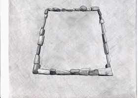
In regions of the Jangtang, west of the 89th meridian, stone enclosures, consisting of a single line of stones embedded in the ground, occur with much frequency. Among these diverse constructions are walls forming perimeters as well as single line stone walls subdividing enclosures into smaller units. These walls are built from naturally occurring chunks of stone, hewn stone blocks, cobbles, and slabs of stone set in the ground edgewise. The most eye-catching among the enclosures are those formed from slabs of stone that project prominently from the surface. A large range of locally available lithic materials were used in construction. It is not unusual for a single enclosure to have been built with more than one type of rock, such as limestone and sandstone together. These fencing stones vary from under 10 cm to over 1m in length. The individual stones of the walls are level with the adjoining terrain or project 10 cm to 60 cm above it. The enclosures vary greatly in shape and include ovoid, sub-rectangular, rectangular, square and irregular forms. Individual structures are between 2 m and over 25 m in length. The sheer differences in scale and the resources needed to build these structures may suggest significant socioeconomic variability. Many of the superstructures are flush with the surrounding ground but others are significantly elevated above it to a height of 1 m or more. There is a continuous elevational progression between the enclosures and burial mounds (bangso). Inside some enclosures, a small ring or mound of stones seems to mark the actual location of a burial chamber.
II.2b) Double-course quadrate, ovoid and irregularly shaped structures (slab wall and flush-block constructions)
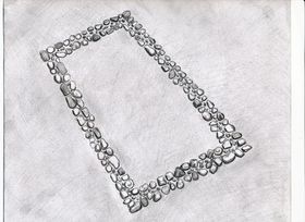
This monument subtype shares the same morphological, constructional and dimensional traits of the single-course walled enclosures, save that the perimeter walls are made with two stone courses running parallel to one another. The walls thus created are between 30 cm and 1.2 m in width. As these walls are inherently more substantial and better developed than single lines of stones, there are many more design variations among them. Most perimeter walls consist of a single layer of prone or upright stones embedded in the ground. In other examples, courses of blocks or slabs were laid flat in successive vertical courses (consisting of two to five layers of stones). These enclosures can quite closely resemble the footings of residential structures (see D-115). In other enclosures, three or more rows of blocks or upright slabs were arrayed in lateral rows to form walls (see D-45). At still other sites, row after row of small stones was stuck in the ground to blanket much of the interior of an enclosure (see D-107). The largest complexes of enclosures feature neatly built double-course walls constructed with cobbles, which sometimes stick prominently out of the ground. Extending over a transection of more than 1 km and numbering in the dozens, these complexes of far western Tibet may be associated with royal burials (see D-41, C-121).
Superstructures with parallel courses of slabs stuck in the ground edgewise constitute one of the most common monumental forms in Upper Tibet. They occur with many constructional variations and in many different sizes. Likewise, in Mongolia and Transbaikalia, the slab graves of the Slab Grave culture (circa 16th to 4th century BCE) represent one of the most widely distributed types of archaeological monuments. While cultural exchanges between the steppes and the Tibetan Plateau are clearly indicated, the distinctive morphological characteristics of the slab graves of Upper Tibet demonstrate that they belong to a unique paleocultural tradition. Rather than a singular class of monuments belonging to one group of people, the respective slab grave builders borrowed upon similar technical knowledge applied to the same purpose in environments largely suited to the herding of livestock. The bones of caprids, cattle and horses are found in the ritual slab enclosures of the steppes. Likewise, drokpa report finding the bones of these zoological genera in the single-course and double-course enclosures of Upper Tibet. Copper alloy artifacts of the Scytho-Siberian type have been discovered in the slab graves of the steppes. Those steppic grave goods compare closely with Tibetan copper alloy objects known as tokchak, the most prominent of which are copper alloy buttons, round mirrors with attachment loops and trihedral arrowheads.
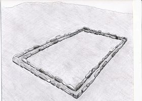
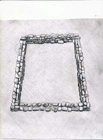
II.2c) Heaped-stone wall enclosures
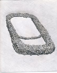
Enclosures created by incoherent or nondescript heaps of stones have the same geographic ambit as the single-course and double-course walled enclosures. It would appear that they were originally comprised of stones piled together to form sub-rectangular, oval and irregularly-shaped enclosures with open interiors. In some enclosures, stones are still heaped to a height of 1 m or more but most are considerably more leveled. The demarcation between the double-course and heaped-stone wall enclosures is somewhat ambiguous, for these forms of funerary construction have many morphological permutations, which are difficult to categorize in one subtype or the other. In the largest single heaped-stone wall enclosure of the Mönra Yarké site, which is known as Dzongchen (Great Fortress) (D-24), excavations carried out to retrieve stones for house and corral construction have revealed chambers constructed with large slabs of stone.1 Radiocarbon analysis of human bone samples taken from these chambers have yielded calibrated dates of circa 710 to 790 CE (leg bone fragment), and circa 610-690 CE (tibial plateau). These measured radiocarbon ages correspond with Tibet’s imperial period (629-846 CE). This demonstrates that the largest burial monument at Mönra Yarké was used to inter human remains during the period of Tibet’s greatest territorial and political expansion.
II.2d) Rectangular mounds (bangso)
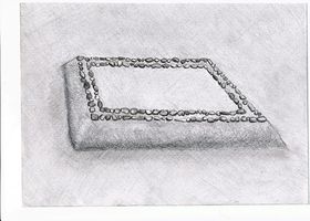
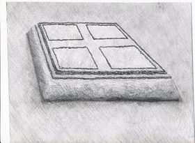
Burial mounds are found throughout Upper Tibet but do not appear to be as common as in other regions of the plateau. These square or rectangular tumuli are elevated on all sides and have inwardly tapering walls. The mounds invariably have flat tops, but the tops now undulate or are concave through the agency of centuries of erosion. I suspect that these mounds contain stone chambers used for interment and mortuary rites, as Tibetan literary accounts indicate. Inner stone chambers may be surrounded by earthen and rubble mantles, which were encased by stabilizing external stone walls crowned with decorative elements. As in Central Tibet, bangso are likely to have been constructed in the northwestern uplands at least until the collapse of the Tibetan empire in the mid 9th century CE. The largest bangso are located in Damzhung (see D-99, D-100), a region adjacent to Central Tibet. The large rectangular mounds (maximum size: 34 m by 32 m by 7 m) of Damzhung have been heavily plundered and are still in the process of being despoiled for valuables. Large quadrate funerary mounds are also found in the eastern Jangtang (see D-76), western Jangtang (see D-40, D-119, etc.) and at the southeastern margin of Gugé (see C-121).
II.2e) Terraced constructions
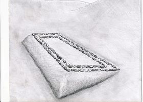
The most common funerary monument in the eastern Jangtang (east of the 89th meridian) consists of quadrate funerary structures built into the sides of slopes. Typically, the downhill or forward side of the structure is elevated 50 cm to 2 m above the slope while the uphill side of the structure is flush or just slightly elevated above the slope. These types of funerary structures form rows that are vertically arrayed, giving them the appearance of terraces. They deviate greatly in size and elaboration. The simplest terraced structures are less than 1 m high on the forward side and have external masonry features limited to a few desultory stones or simple single-course walls along the rim, and measure just 2 m to 3 m across. Conversely, the largest specimens measure 12 m by 14 m, and are like bangso in appearance. Large terraced tombs sometimes boast elaborate masonry work in the manner of bangso. In fact, in the eastern Jangtang, the delineation of the mounds and terraced funerary structures is not always clear. Some cemeteries have both kinds of structures, indicating that the mound and terraced forms of burial are closely interrelated. The largest terraced cemeteries have in the neighborhood of 200 tombs each (see D-74, D-75).
There is also a class of terraced structures in Rutok that exhibits different morphological features from its eastern counterpart. These small terraced structures are tightly arranged in a vertical line along a steep slope to produce a stepped effect (see D-66, E-16). From the remaining structural evidence, it would appear that these structures had random-rubble masonry forward and side walls, which were deeply built into the slope. The rear masonry wall, if there is one, is totally engulfed by the slope. The tops of these terraced structures may have been completely covered in stonework. The funerary nature of the stepped structures is corroborated by the local oral traditions. The cultural and chronological relationships between the terraced funerary structures of the eastern and northwestern Jangtang is still unclear.
- ^ Bellezza, Antiquities of Upper Tibet, 88-89.
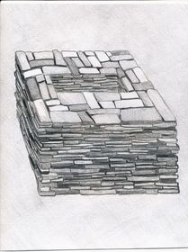
Another characteristic class of archaic monuments in Upper Tibet is cubic stone tombs. In this survey, 22 such sites are presented. The above-ground cubic tombs were erected on the tops of high ridges and mountains to an elevation of 5600 m. The cubic tombs were almost always sited on summits thickly blanketed in talus. They were frequently set on the edge of high points overlooking steep slopes or cliffs with panoramic views of the adjoining countryside. These sites often comprise the highest ground around for some distance. The cubic tombs were generally built of locally occurring dark-colored sandstone and volcanic slabs and chunks (up to 1.2 m in length), laid flat in random-texture, dry-mortar courses. The exterior dimensions of the tombs range between 1.5 m by 1.5 m by 1.2 m and 2.5 m by 3.5 m by 1.8 m. The walls are usually aligned in the cardinal directions, an important feature of many pillar and enclosure sites as well. The top of the tombs are flat, and virtually all have been opened and the contents discarded or stolen.
There is a rectangular chamber set in the center of the masonry carapace elevated around 50 cm above ground level. Measuring in the range of 80 cm by 50 cm to 2 m by 1.1 m, finer sized stones were used to fashion these central chambers. The chambers are also normally aligned in the compass points. These 70 cm to 1.1 m deep openings appear to have functioned as reliquaries. Their association in the oral tradition with the ancient Mön and the occasional adventitious usage of the chambers to accommodate human burial bear this out. It would appear that skeletal elements, the products of fractional or secondary burials, were deposited in the central chambers. Given their size, extended corpse burials would not have been feasible (unless they were used for juvenile inhumations) except in the largest central chambers, a small minority of the total. Tibetan historic era reliquary structures are mud plastered and colorfully painted, and it does not seem likely that the cubic tombs were originally fabricated as raw unadorned stone chests.
Curiously, the geographic distribution of the cubic tombs is restricted to western Tibet. They occur both north and south of the Transhimalaya (Gangkar Tisé) range, between 84° 33΄ and 79° 03΄ E. Longitude. The cultural factors explaining why the cubic mountaintop tombs are confined to this specific region are still obscure. Other characteristic monuments of Upper Tibet, such as the all-stone edifices, pillars erected inside quadrate enclosures, and arrays of pillars appended to edifices, enjoy much wider territorial dispersal
A Bön scriptural account seems to describe a form of burial for ancient priests known as shen, which may correspond to the form and lofty aspect of the cubic mountaintop tombs.1 If indeed this textual source is related to the tombs under consideration, it indicates that they were used to dispose of the mortal remains of high status priests in prehistoric times. Clearly, the siting of tombs in high, inaccessible locales intimates an exclusive social sphere of usage. This aura of special status is supported by the relatively small number of such cemeteries thus far documented.
I have presented ethnographic data to suggest that the lofty aspect of the sites was connected to a belief in a celestial afterlife.2 This is also supported by Tibetan funerary texts that describe a celestial afterlife known as gayül (Joyous Country), a paradise paralleling in ideal terms the mortal way of life.3 It would seem that the mountaintop tombs served as a kind of launch pad for the deceased on its journey to the hereafter. Some mountaintop sites (see E-11, E-19, E-30) with their terraces, pads, pathways and walls, all constructed from talus, indicates that there was indeed a complex ceremonial component attached to the burials.
Special attention has been paid to identifying and collecting osteological samples from the ruins of the central depositories. Only a small fraction of the total number of tombs contain skeletal remains and these are all tiny, hard to distinguish fragments. The samples collected were partially or fully exposed to the elements and subject to infiltration by foreign organic substances. Samples taken from tombs of the Endritsé (E-11) (fragment of cranium, human?) and Denjangri Mukpo Dong (E-18) (human cuspid and jaw fragment, other bone matter) cemeteries have yielded dates so recent as to fall outside the range of radiocarbon calibration. One sample of bone (species undetermined), collected from the central depository of a cubic tomb near Denjangri Mukpo Dong, has yielded a calibrated radiocarbon date of circa 1000 to 1210 CE. It is not at all clear, however, if the sample dated represents part of an original interment or a subsequent addition to the tomb. More stringent sampling will be required in order to determine the age of the cubic tombs.
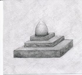
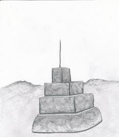
At a number of residential sites in Upper Tibet , there are the ruins of shrines that can be assigned to the archaic assemblage of monuments. These structures are found both outdoors and in caves used for habitation. Most of them appear to belong to the tenkhar, sekhar, lhaten, or lhatsuk classes of monuments, cubic or stepped tabernacles used to enshrine and propitiate indigenous deities. While forms of these monuments are still constructed today, according to Bön tradition, their origins can be traced to prehistoric times. Fairly well-preserved examples sheltered in caves are sometimes covered in a mud veneer and decorated with red and yellow ochre and lime pigments. The shrines have square or rectangular bases and were built of stone slabs and blocks. Some specimens may have had elaborate superstructures, as indicated by the depiction of archaic shrines in the rock art of Upper Tibet, but few traces remain. Archaic shrines can be distinguished from the ruined bases of chöten by the absence of overhanging masonry tiers, coursed-rubble stonework, etc. Also, unlike chöten, some archaic shrines were partly built underground. It is probable that a wide range of ritual functions and chronologies is indicated for this heterogeneous class of ceremonial monuments.
Only two sites surveyed to date are composed exclusively of shrines. Pangar Zhungkhang Gok (F-1) consists of six large cubic structures, situated on the edge of an extensive pastureland.1 It is possible that the limestone structures of Pangar Zhungkhang Gok represent an unknown type of above-ground tomb, as their construction is locally attributed to the ancient Mön. The celebrated monument known as Guru Bumpa (F-2), located in Purang, is maintained to the present day (it was partly destroyed in the Chinese Cultural Revolution). It consists of two large unmortared stepped structures chiefly built of cobbles tinted red with ochre. According to the local myth, the 8th century CE Vajrayāna hero Guru Rinpoché magically built these twin shrines in the amount of time it took for his disciple to prepare a pot of rice. Stepped shrines of the same form are a significant motif in Upper Tibetan petroglyphs and pictographs, all of which appear to predate the 13th century CE.2
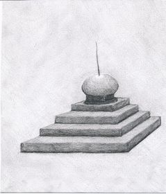
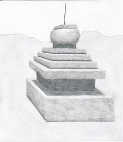
In the vicinity of some residential sites there are the remains of agricultural terracing and irrigation channels. Walls bounding long abandoned arable parcels (zhingsa) are common in western Tibet (including sites A-13, A-42, A-60, A-62, A-87, A-89, A-101, A-106, A-125, A-126, B-50, B-79, B-81, etc.). These former agricultural enclaves are commonly attributed to the ancient Mön, who are supposed to have cultivated large areas of what is now only pasturage. At many erstwhile agrarian sites in western Tibet, all perennial sources of water have dried up. Defunct agricultural holdings are also evident on the shores of Dangra Yutso, in the central Jangtang (including sites B-4, B-6, B-55, B-57, B-58, B-59, etc.). Some of these Lake Dangra sites are attributed, in the local oral tradition, to the prehistoric Zhang Zhung kingdom. The Lungön site (G-3) is especially noteworthy because the water it carried from deep inside the Lungön Valley flowed to Dangra Khyungdzong (A-5) a fabled capital of Zhang Zhung.
In the face of appreciable geographical evidence, the legends circulating in Upper Tibet (west of the 87th meridian) that tell of much more widely practiced agriculture in ancient times, are undoubtedly based on an authentic collective memory. Rutok, Gugé, and Gar, in particular, were very much more heavily farmed in the past. These former arable lands are frequently encountered in proximity to ruined villages and citadels, many of which now lie totally deserted. One implication of larger locally produced grain reserves is that they may have been used to sustain larger populations. The oral traditions of Rutok claim so much, stating that this district in ancient times supported upwards of 100,000 people, ten times the current population.1 While such legends are hyperbolic, they do seem to preserve an authentic memory of a more developed past in parts of Upper Tibet.
- ^ Bellezza, Antiquities of Upper Tibet, 31.
This division of monuments is geographically confined to the south side of the Nyenchen Tanglha massif, in the Nyingdrung and Damzhung localities. Four sites, consisting of broad earthen walls, 2 m to 3 m in height and of similar width, have been surveyed. These walls form quadrate structures up to 250 m in length. Within these walls there is highly disturbed ground covered in pits and small mounds. Earthen platforms are found near some of the walled structures. There is great scope for further exploration of these enigmatic structures.
In this residential type are all habitational structures located on the summits and prominences of mountains, ridges, hills, and high rock formations. By the very nature of these geographic locations, such monuments have an inherent defensive aspect to a lesser or greater extent. Among this residential type are edifices that functioned as fortresses and citadels (habitations designed and built for military purposes), temples and hermitages (buildings with a religious or ceremonial function), palaces (social elite residential buildings), and breastworks (networks of ramparts or other types of defensive structures that were temporarily or permanently inhabited). It must be noted that, from a visual appraisal alone, the specific occupational functions of individual edifices or components thereof can only be inferred. In any event, these strongholds, temples, palaces, and hermitages appear to have been where the ruling and priestly classes exercised their social influence and political control over the agriculturalist and pastoralist sectors of society.
Basic site data
- Site name: Nam Dzong
- English equivalent: Sky Fortress
- Alternative site name: Sem
- English equivalent: Meditation Fortress White Rock Formation
- Alternative site name 2: Semdzong Drakkar
- English equivalent: Meditation Fortress Rock Formation Castle
- Site number: A-48
- Typology: I.1c
- Elevation: 5000 m to 5070 m
- Administrative location (township): Baryang
- Administrative location (county): Drongpa
- Survey expedition: UTAE
- Survey date: April 13, 2001
- Contemporary usage: None.
- Identifiable Buddhist constructions: None.
- Maps: UTRS XI, HAS C5
- View Place Dictionary Entry
- View Site Images
General site characteristics
Sky Fortress is located just east of Dragon’s Nest (Drukmö Tsang), the relatively low-lying pass (4710 m) connecting Baryang with Tara monastery. The site is named for Lhamo Drukmo after the wife of the epic hero, Ling Gesar. The ancient fortifications are situated on subsidiary summits of the west half of the approximately 5300 m high Sky Fortress formation. The installation enjoys good views to the west and north and, in some places, to the southwest as well. Its defensive capability was certainly focused in these directions as Sky Fortress affords no protection from or advance notice of attack from the east. Sky Fortress consists of a broad network of dry-stone random-work defensive walls lacing the upper flanks of an eponymous limestone mount. The ramparts appear to have been less than 2 m in height, and were constructed from uncut pieces of limestone up to 1.2 m in length. The northern and western orientation of the site supports the oral tradition that military incursions took place from these directions. The ramparts, staggered at various levels across Sky Fortress, must have provided the defenders with significant vertical and lateral mobility, allowing the rock formation to function as an integrated defensive feature. In recent years, mani mantras have been carved into the limestone walls of the formation, reflecting the sacred nature of the locale.
Oral tradition
According to local legend, the Tibetan epic hero, Ling Gesar, came to the Sky Fortress region to battle the king of Takzik, King of Wealth (Norgyi Gyelpo). King of Wealth is said to have had his stronghold in the Tiger Gorge (Takrong) and Zikrong valleys to the northwest. This king was very powerful like a tiger and very wealthy because the lu (water spirits) were his patrons. The defeat of King of Wealth came when his army was routed in a surprise attack from Sky Fortress. Gesar is said to have been so powerful that from Sky Fortress he could hit an enemy position with his bow and arrow, some 30 km to the north, a place which came to be known as Benkar Deu (White Target Hill).
Site elements
East complex
This highest group of ruins consists of a retrenchment built on a narrow, flat summit. It measures 25 m in length and up to 1.3 m in height.1 In close proximity there remain small segments of other walls. Also in the vicinity there is a small natural tunnel called Wolf's Lair (Changtsang) and a natural archway, which are said to cure goats and sheep of diseases when they pass through these hidden features in the formation.
Central east complex
The central east complex is located farther west at a slightly lower elevation. This comprises the vestiges of an approximately 50 m long wall, set in a narrow ravine, which is squeezed between two steep limestone slopes. As this site has no open vistas, the relatively secret and sheltered location may have been used to garrison troops or store supplies. The area between the manmade wall and formation is only around 2 m wide. Potentially, this space could have been covered with tarpaulins to produce temporary shelters.
Central west complex
The central west complex is located farther west at lower elevation. This group of ruins straddles the top of a saddle with sweeping views to the north and west. The dispersion measures 80 m (north-south) by 30 m (east-west). There are also minor structural remains atop the formation west of the saddle. On the east side of the saddle, a wall seems to have spanned the 11 m wide base of a natural archway. This wall has been reduced to 7 m in length, and is a maximum of 1.5 m in height and 1.2 m in width. There are smaller structural traces found underneath and on top of the arch. Also on the saddle are four small limestone outcrops, with a total of at least six ruined structures each around 9 m² in area and 1.5 m or less in height. Called Gesar’s incense brazier (sangkhang), these structures must have functioned as surveillance posts or donjons. There may have been a rampart wall along the north rim of the central west complex saddle but not enough remains to make a determination. Just below the south side of the saddle, there is a defensive wall (30 m long, up to 1.5 m in height) enclosing the flanks of the formation.
West complex
The west complex is located directly below the steep south face of the central west complex. The most prominent ruin is known as Gesar’s house (khangpa), a residential structure measuring 8 m (east-west) by 6 m (north-south). Walls up to 3 m in height have survived. These walls have a random-rubble, dry-stone fabric, in the same fashion as the ramparts. In the vicinity of Gesar’s house, there are the vestiges of a lengthy rampart (100 m long) and other smaller structural remains. At approximately 20 m lower down there are walls 19 m and 21 m in length, enclosing a level area on the side of the formation. These walls are up to 1.6 m in height. A little to the west and at a slightly higher elevation there is another defensive wall (18 m long) that also appears to have once enclosed a shelf, which is now obscured by rock fall deposits.
- ^ Unless otherwise noted dimensions provided throughout this work are for the maximum visual extent of the structure under appraisal. The dimensions of some structures can only be approximately determined because they do not readily lend themselves to measurement. In some cases, structures are partially obscured by soil or rubble, or sections are missing, rendering measurement difficult. Uncertainties may also arise in reference to the interface between manmade structures and the natural terrain. This has the effect of creating more or less arbitrary baseline measurements.
Basic site data
- Site name: Dzong Pipi
- Site number: A-49
- Site typology: I.1a
- Elevation: 4800 m (lower site), 4840 m (upper site)
- Administrative location (township): Baryang
- Administrative location (county): Drongpa
- Survey expedition: UTAE
- Survey date: April 15, 2001
- Contemporary usage: Almost none at the upper site. The lower site has been used for many years as a pastoral shelter. It is only inhabited very infrequently.
- Identifiable Buddhist constructions: None.
- Maps: UTRS XI, HAS C5
- View Place Dictionary Entry
- View Site Images
General site characteristics
The upper site of Dzong Pipi is dominated by a single five-sided building planted on top of a pyramidal limestone formation, which rises 150 m above the south margin of the Tsachu basin. This site has commanding views of this large basin and the Transhimalaya to the north. In the proximity are two small caves that were modified for human habitation. The lower site consists of a cave with a three-story masonry façade. Significant early inscriptions in red ochre are found here.
Oral tradition
Local sources believe that the upper site of Dzong Pipi was built and inhabited by a sinmo demoness, which was subdued by the Vajrayāna hero, Guru Rinpoché (eighth century). The site is considered ka nyenpo (potentially hazardous).
Site elements
Upper site
Summit edifice
The edifice of Dzong Pipi1 has a modified square plan. The existence of a stone-roof in one section of the building and its general design and constructional characteristics indicate that it was an all-stone corbelled structure. The four main walls of Dzong Pipi are quite closely aligned in the cardinal directions and each measure 4.5 m in length. A fifth or southwest wall facet is 2.2 m in length. The random-rubble block-work walls (50 cm to 60 cm thick) appear to have been lightly mortared. Variable-sized slabs were used to build the walls, a common archaic style of construction. The walls rise up to a height of 3 m to 4 m on the exterior side and 2 m to 2.5 m internally. The entranceway was in the south. There are windows in the north wall (20 cm by 30 cm) and east wall (30 cm by 35 cm). A southwest room has survived largely intact while other internal partitions have been nearly effaced. The southwest room (outer dimensions: 2 m by 2.5 m) is set 50 cm below the rest of the floor level. An opening in the lower portion of its outer wall may indicate that it functioned as a lavatory. The roof of the southwest room is entirely intact: two bridging stones (each more than 1.5 m long) support the stone-slab roof sheathing.
Caves
Approximately 200 m south of the summit edifice, on a limestone shoulder, there is a very small cave with the remains of a façade (3 m long, 1 m high) built around it. Just below this façade there is a retaining wall built into the rock face. Approximately 200 m southwest of the summit edifice there is a cave (3.5 m deep) with the remnants of a stone façade (3 m long). In the rear of this cave there are niches and a stone bench that could have had either utilitarian or ritual functions. The cave is now used to store the belongings of a local drokpa family such as winter coats. Long ago a hole was bored into the roof of this cave, ostensibly as a smoke vent. In front of the façade there are the remains of walls (4 m by 3.5 m) that seem to have once been part of an anteroom.
Lower site
Cave house
The lower site of Dzong Pipi is situated below the stronghold, on the east side of the formation. It is dominated by a narrow cave (6.5 m deep), which has a three-story stonewall built around its mouth. This structure was made of variable-sized stone slabs laid in random-work courses, which appear to have been lightly mortared. The lowest tier of the outer wall incorporates a stairway that is now almost completely destroyed. At the base of the stairway there is a landing. The middle level of the façade contains the entranceway, which is 1.7 m in height and 60 cm wide on its exterior side. There are several steps, set inside the entranceway (1 m long), which access a much smaller inner portal. The 1 m long lintel over the entranceway is the largest stone used in the construction of the façade. The upper level of the façade encloses much of the cave and supports a small window. The middle and upper levels of the façade form a single masonry expanse, 5.4 m in height and nearly 3 m in width.
Near the entranceway of the cave, “Om A Hum” and a counterclockwise swastika were inscribed in red ochre in a vertical row. Nearby, there is another red ochre counterclockwise swastika. In the formation above the façade, there is a red ochre clockwise swastika, and a Wuchen inscription that seems to read: “Jenso nampé chi.” This inscription appears to convey the Buddhist depreciation of the site. In the rear of the cave there is a panel consisting of a red ochre sun and moon, a tree-like depiction, two rudimentary specimens of the letter “a,” and several heavily obscured compositions, all of which form a horizontal array. Like the letters and swastikas near the entrance, this panel was almost certainly painted by the Bönpo. The motifs on the panel, on the basis of style and paleography, however, seem significantly older than the pictographs near the entrance. The existence of these letters and symbols establishes the Bön occupation of Dzong Pipi, a period of tenure that must be related to the local tale of the sinmo.
Other structures
Just south of the cave, there is a wall (4 m long, up to 1.5 m high) that bounds a level area in the formation 2.5 m deep. This appears to have been the base of another building but not enough remains to be certain. A little higher up is a shallow southeast-facing cave with the vestiges of a façade and an inferior retaining wall.
- ^ Pipi may have a Zhang Zhung language etymology. In the ninth century CE, the Tibetan military governor of Shen, Zang Pipi/Zang Peipei, was of Zhang Zhung origin (Beckwith 1987: 169).
Basic site data
- Site name: Takzik Nordzong
- English equivalent: Tiger Leopard Fortress
- Site number: A-50
- Site typology: I.1c
- Elevation: 4870 m to 4890 m.
- Administrative location (township): Khyelak
- Administrative location (county): Drongpa
- Survey expedition: UTAE
- Survey date: April 20, 2001
- Contemporary usage: None.
- Identifiable Buddhist constructions: None.
- Maps: UTRS XI, HAS C5
- View Place Dictionary Entry
- View Site Images
General site characteristics
Tiger Leopard Jewel Fortress is located at the confluence of the Ronggyü and smaller Fortress Valley (Dzonglung) valleys, neither of which has any contemporary permanent settlement. The ancient stronghold consists of two light-colored limestone formations that stand side by side. Their upper flanks are crisscrossed by defensive walls. From the higher west summit, which rises 70 m above the confluence, there are excellent views of the Ronggyü river valley. The serpentine defensive walls were established at various elevations along the precipitous south side of the twin limestone formations. The extensive random-work, probably dry-stone defensive walls are built of slabs of stone up to 1 m in length. The level areas created behind the ramparts must have functioned as temporary living and working quarters, as well as for defense. By circumscribing the limestone mounts with walls, the defenders were able to move around in relative ease and could direct their salvos accordingly. Like Sky Fortress (A-48), the walls of Tiger Leopard Jewel Fortress are highly eroded and there can be little doubt regarding their antiquity. There are also a number of minor archaeological sites in the Fortress Valley valley.
Oral tradition
Local drokpa believe that Takzik Nordzong is one of the fortresses of Tiger Leopard King of Wealth (Takzig Norgi Gyelpo), an invader who is supposed to have come from the northwest (Indo-Iranic borderlands or Central Asia). He is thought to have conquered major portions of western Tibet in early times. According to the Gesar epic, Takzig Norgi Gyelpo was one of the main adversaries of King Ling Gesar.
Site elements
West formation
Ramparts enclose both the south and east sides (sides overlooking the confluence) of the west formation. Its summit measures 24 m (east-west) by 7 m (north-south) and is ringed by a now discontinuous parapet (up to 1.5 m high). Along the near vertical southwest side of the summit, a defensive wall was probably not required. Within these walls, there is what appears to be the foundation of a small building (4.6 m by 3.8 m); its wall footings are 75 cm thick and up to 1.2 m in height. What may be another building foundation (5.4 m by 4 m) is located just below the west side of the summit, and was built against a rock face. Only walls 50 cm or less in height have persisted among these footings. Approximately 20 m below the summit, a defensive wall (60 m long) encircles the entire south flank of the formation. Small segments, however, are missing. This rampart is a maximum of 1.5 m high on its down-slope side and usually flush with the uphill side of the formation. It is up to 1.5 m wide and appears to have also functioned as a pathway that could easily be walked or camped on. The east and west ends of this long rampart terminate at unassailable cliffs.
On the north side of the west formation there is a wall segment (6 m long, 2 m high), which may possibly have been the foundation of another small building. There are also wall fragments, the remnants of outworks, at the base of the formation. A minor wall segment is found near the east base of west formation, overlooking the east formation. There are also three wall sections near the south base of the west formation, 5 m, 8 m and 6 m in length. There appears to have been yet another defensive wall segment hugging the south slope of the west formation, but it is almost completely destroyed.
East formation
There are the remains of a curtain-wall linking the east and west formations (63 m long). Much of this wall is now leveled, but certain sections along its north side reach 1 m in height. The south side of this structure is flush with the ground level. There is some structural evidence (courses of masonry protruding above the ground) to indicate that there was a parallel wall situated 2.5 m to the south. The east formation has a single defensive wall on its south side, 90 m in length. Much of this 1.5 m high, 1.5 m thick structure is still intact. Small traces of the rampart continue around to the west side of the hill.
Dzonglung archaeological sites
In Fortress Valley (Dzonglung) there are a number of minor ceremonial structures, which like the rampart network, must have been part of the erstwhile permanent settlement of the locale. There is ample water and plenty of drama brush here. On the south side of the mouth of the Fortress Valley, opposite Tiger Leopard Jewel Fortress, there are the remains of a double-course slab wall engulfed by drama brush. The visible wall segment is 6 m in length and 50 cm in width, with the upright slabs protruding a maximum of 30 cm above the ground. The morphological characteristics of this monument feature indicate that it is probably part of a funerary superstructure. There is also what appears to be a building foundation in the mouth of the Fortress Valley. A little way up the Fortress Valley, on a bench along the right side of the watercourse, there are the ruins of two tabernacle (tenkhar)-like shrines (4830 m). The base of one specimen is largely intact (1.9 m by 3.4 m), while the other one has been nearly leveled (approximately 6.4 m by 3.2 m). Small pieces of stone plaques inscribed with mani mantras are found near the ruined shrines. Several kilometers upstream, the Fortress Valley bifurcates. In the middle of a pastoral camp, near this confluence, there are the remains of another shrine, probably of the tabernacle type (4910 m). Approximately 200 m downstream there is a Mön enclosure (mönra), a heaped-stone wall enclosure (10 m across), built with stones up to 90 cm in length. This structure appears to be funerary in character.
Basic site data
- Site name: Wangchuk Gönpo Khar
- English equivalent: Mighty Protector Castle
- Site number: A-51
- Site typology: I.1a, I.1b
- Elevation: 4970 m to 5000 m
- Administrative location (township): Horpa
- Administrative location (county): Drongpa
- Survey expedition: UTAE
- Survey date: April 21, 2001
- Contemporary usage: Light grazing.
- Identifiable Buddhist emblems: A mani wall and chöten (chöten).
- Maps: UTRS XI, HAS C5
- View Place Dictionary Entry
- View Site Images
General site characteristics
Castle of Wangchuk Gönpo Khar is perched on the top and southern flank of a hill that rises out of the basin of Owl Valley (Ukpa Lung). The hill is not impregnable, in that access along its western and southern approaches is relatively easy. The strength of the geographic setting comes from the fact that it is highly isolated (it is far removed from other archaic residential sites as well as modern centers of settlement). There are the ruins of some 60 formidably constructed buildings at Wangchuk Gönpo Khar. Many of these structures were two or even three stories in height. Covering an area of nearly 6000 m² (118 m by 49 m), Castle of Wangchuk Gönpo is one of the largest citadels surveyed to date. Most structures were built of random-work masonry, using a light-colored mud-based mortar adhesive. Roofs were mainly constructed with stone corbels, fitted into socket-holes, upon which timbers must have rested. In some instances, a band supported by corbels was constructed to act as a load-bearing structure for the timbers of the roof. A single mani wall and chöten are found north of the castle complex. These Buddhist structures appear to have been constructed at a much later date.
Oral tradition
According to local sources, Wangchuk Gönpo was the powerful dü demon ruler of the region. He came under attack by a Tibetan Buddhist army who laid siege to his castle. For a few months the castle withstood the assault, but its water supply was finally extinguished. Not wanting to let this vital fact be known to the Tibetans, Wangchuk Gonpo ordered that his troops smear butter on their hair to simulate that they had just bathed. This ruse had the intended effect and the Tibetan king believed that the castle still possessed ample water reserves. Not willing to wait much longer, the Tibetan king wanted to storm the castle but his army had used up their salt supply. Consequently, retreat was imminent. That night, the great Vajrayāna adept Guru Rinpoché (eighth century) manifested in the dream of the Tibetan king as two yellow ducks which led him to a nearby salt mine. The next morning, using the geographic cues provided in his dream, a minister of the Tibetan king was able to find the salt mine. The attack of the castle could now go ahead and it proved successful, leading to the defeat of the dü king.
Site elements
Fortress
The legend claiming that castle of Wangchuk Gönpo belonged to the dü (a class of indigenous demon/deity) suggests that it was part of the archaic cultural infrastructure of the region. This oral tradition may chronicle a localized incident in the fall of Zhang Zhung and its annexation by the Pugyel state of Central Tibet. According to Loppön Tendzin Namdak, the foremost Bön scholar, it seems likely that the Castle of Wangchuk Gönpo citadel is actually that of Gegi Jiwa Khar, one of the premier prehistoric Zhang Zhung centers according to the Bön textual tradition.1 The castle possesses archaic architectural features such as corbelled stone roofs, small windowless rooms (3.5 m² to 12 m²) and low entranceways (1.1 m to 1.4 m in height). Its great elevation is another indication of considerable antiquity, as no major facilities in Upper Tibet were built at 5000 m in the historic epoch. Another indication pointing to an archaic cultural origin is the lack of Buddhist monuments contemporaneous with the Castle of Wangchuk Gönpo (Wangchuk Gönpo Khar).
The main collection of buildings at Castle of Wangchuk Gönpo is found on a limestone outcrop. Other structures are scattered below on the south flank of the hill. The citadel seems to have been built with locally quarried limestone cut into flat blocks 40 cm to 1 m in length. The upper walls of a few buildings were constructed of rammed-earth. Wall elevations of 2 m to 4 m are common throughout the site, and the tallest extant fragments reach 8 m. The highest rammed-earth segment is 5 m. Wall thickness ranges between 50 cm and 80 cm. Buildings that may have had relatively large halls are located in the upper northwest corner of the site. All entranceways appear to have been built with stone lintels, many of which are still in situ. These doorways are only 50 cm to 70 cm in width. At the junction of the ground and first floors of buildings, square socket-holes are in evidence, some of which still have stone corbels inserted in them. These structural elements were employed to support the flooring of the first story. The roofs must have been built in a similar fashion, using sockets and corbelling. The corbels are not massive (around 5 cm thick) and project a maximum of 50 cm from the walls. Given these dimensions and the wall spans involved, the floors and roofs could only have been made of timbers and not with heavy stone members. No pieces of wood, however, were recovered from the site.
In the lower west sector of the complex there is a passageway (interior dimensions: 2.7 m by 50 cm) with an all-stone corbelled roof, built under a larger room. Another similarly constructed passageway lies adjacent to it, but it is filled with rubble and only a few corbels remain in place. In the lower central sector there is also an alcove (interior dimensions: 80 cm by 1.3 m) with an all-stone roof, which is part of the lower level of a building. On the west side of the hill, below the main group of ruins, there are three narrow semi-subterranean rooms that also appear to have had all-stone roofs.
- ^ Bellezza, Zhang Zhung.
Basic site data
- Site name: Mapang Pömo Khar
- Alternative site name: Kharchen
- English equivalent: Great Castle
- Site number: A-52
- Site typology: I.1
- Elevation: 4730 m
- Administrative location (township): Horchu
- Administrative location (county): Purang
- Survey expedition: UTAE
- Survey date: April 23, 2001
- Contemporary usage: Light grazing.
- Identifiable Buddhist Constructions: None.
- Maps: UTRS X, HAS C4
- View Place Dictionary Entry
- View Site Images
General site characteristics
Mapang Pömo Khar is situated on the summit of a white limestone outcrop rising 50 m above the left bank of the Rock Formation River (Drak Tsangpo) river. The steep flanks of the formation endow the site with a good defensive aspect. The stronghold is due east and directly in view of the important Bön holy mountain Pori Ngeden. The Mapang Pomo Khar citadel is divided by a saddle into north and south summits. The highly deteriorated remains consist of cobble (primarily 15 cm to 50 cm in length) rubble and fragmentary wall-footings. Some small sections of the revetment along the rim of the hill have also survived. There are no free-standing walls left at the site.
Oral tradition
Great Castle is said by local elders to be a castle of prehistoric Zhang Zhung, some of which refer to it as Mapang Pömo Khar, a name recorded in the famous Bön pilgrimage register, Tisé Karchak by Karru Drupwang (b. 1801). Other local elders report that it is an ancient Singpa (generic term for invaders coming from the west) facility.
Textual tradition
A recently authored supplement to the Tisé Karchak furnishes Bön lore about the Pori Ngeden locale. Much of the legendary material in this account was compiled by the late Bön physician, Tendzin Wangdrak (1922–2006). In this work it would appear that Mapang Pömo Khar is equated with a site called White Formation Summit Fortress (Drakkartsé Dzong):1 “On the east side of Pori Ngeden, at White Formation Summit Fortress, the great religious community (düdé) of Yungdrung Lhatsé had one thousand arhats (drachom). It was established by the Zhang Zhung abbot Yungdrung Tsültrim.”2 Given its relative position and description as a white rock formation, it seems likely that White Formation Summit Fortress is indeed represented by the ruins under consideration. The literary account continues by stressing the paramount importance of Pori Ngeden to Zhang Zhung history and the Bön religion:3
On the west side of Pori Ngeden, on the slopes of the mountain Pelpu, the monastery of Yungdrung Chokteng had 1600 religious practitioners (neten). It was established by the Zhang Zhung abbot Trimbar Tsukpü. Also, on the south side [of Pori Ngeden], at the mountain of Rompo Pel, the great religious community of Superimposed Swastika (Yungdrung Tsekpa) had more than one thousand monks (gendün). It was founded by Tsukpü Tsültrim. There is much other history [at Pori Ngeden]. Presently, it is evident that the [Bön] doctrine was transferred to other [places]. Around the vicinity of Zhang Zhung Pöri Ngeden the ruins of old monasteries and fortresses are everywhere visible. Later, some of them were turned into the places of other religions and each of them has its own history.
Site elements
South summit
The south summit dispersion measures 65 m by 10 m to 15 m. It is blanketed in igneous and other types of cobble rubble, which disgorge from both sides of the steep summit. It would appear that a dense collection of buildings once occupied the site. However, as only partial wall-footings remain, little can be said about the layout and design characteristics of these structures. On the north and west side of the hilltop, small sections of 1 m high revetments survive. The highest portion of Mapang Pömo Khar is the north end of the south summit.
North summit
This dispersion measures 37 m by 6 m (north end) by 13 m (south end). Like its southern counterpart this sector is covered in rubble, which suggests that a thick cluster of buildings once stood here. The only structural feature that has endured is remnants of wall-footings. A saddle 25 m in width connects the two summits of Mapang Pömo Khar. The traces of a curtain-wall running between the two summits are found on the west side of this saddle.
- ^ See Gangs mtsho’i nye ’khor gyi dgon pa khag, 53: yang spos ri ngad ldan gyi shar phyogs shel gyi brag dkar rtse rdzong du g.yung drung lha rtse’i ’dus sde chen po dgra bcom stong phrag dang ldan pa zhang zhung mkhan po g.yung drung tshul khrims kyis btab/.
- ^ In the Ti se dkar chak, Yungdrung Tsültrim is credited with propagating the Bön doctrine at Khyungchen Pungpé Ri. For this account, see Bellezza, Antiquities of Northern Tibet, 59, 60.
- ^ Bstan ’dzin dbang grags, “Gangs mtsho’i nye ’khor gyi dgon pa khag,” Zhang zhung rig gnas: 53: spos ri ngad ldan gyi nub phyogs dpal phu'i ri ldebs su g.yung drung mchog steng gi dgon pa gnas brtan stong dang drug brgya ldan pa zhang zhung mkhan po khri 'bar gtsug phud kyis btsugs/ yang de'i lho phyogs hrom po dpal gyi ri la g.yung drung brtsegs pa'i 'dus sde chen po dge 'dun stong phrag lhag ldan gtsug phud tshul khrims kyis bzhengs pa sogs lo rgyus mang yang nye dus bstan pa gzhan la 'phos pa ltar snang rung zhang zhung spos ri ngad ldan gyi nye 'khor rnams su dgon shul lam mkhar shul rnying pa gang sar mjal rgyu yod pa dang / kha shas phyi su grub mtha’ gzhan gyi gnas su 'gyur ba dang rang rang gyi lo rgyus dang bcas pa gsham gsal/.
Basic site data
- Site name: Gya Nyima Khar
- English equivalent: Big Sun Castle (?)
- Site number: A-53
- Site typology: I.1b
- Elevation: 4670 m
- Administrative location (township): Khyunglung
- Administrative location (county): Tsamda
- Survey expedition: UTAE
- Survey date: April 29, 2001
- Contemporary usage: Light grazing.
- Identifiable Buddhist constructions: None.
- Maps: UTRS V, UTRS X, HAS C3
- View Place Dictionary Entry
- View Site Images
General site characteristics
The castle of Big Sun Castle is located on a flat summit, which rises approximately 150 m out of the expansive Gya Nyima basin. The site enjoys views in all directions and a panoramic sweep of the Uttarakhand Himalaya. A dry-stone random-rubble parapet was constructed around the entire rim of the summit, which measures 160 m (east-west) by 32 m (north-south). A number of ruined buildings are located within this wall, the most prominent of which is an earthen and stone structure on the east end of the summit. Both adobe block and rammed-earth were used in the construction of Big Sun Castle. At this juncture, none of the rammed-earth wall structures found at Gugé sites, such as Gya Nyima, can be confidently attributed to the archaic cultural horizon. It is also worth noting that rammed-earth constructions are very seldom encountered at Jangtang residential centers attributed by local sources to the prehistoric epoch. It seems likely that at least some of the remains at Big Sun Castle represent a Lamaist era facility.
Oral tradition
Some local residents claim that the fortress of Gya Nyima Khar was built before Horned Eagle Valley Silver Castle (Khyunglung Ngül Khar), the fabled capital of prehistoric Zhang Zhung, but it was never inhabited. As little wealth had been allocated for its construction by the holder of the bird-horns (jaru chen) Zhang Zhung king, the fortress was small and poorly built. When it was completed the king was pleased, however, and offered the head builder a large sum of gold. People encouraged the king not to inhabit Big Sun Castle, as it was of substandard construction. It was believed that its geographic aspect is inauspicious because to the east there is a mountain in the form of a wailing man, to the north there is a wild yak butting in the direction of the fortress mountain, to the south a howling wolf mountain, and to the west the blackened lid of an upset cauldron (langnga) mountain. Residents of Khyunglung township also tell a similar tale set in the historic epoch. It is also said that Big Sun Castle had a military rivalry with the castle of Mistress Mountain Castle (Jomo Rirang Khar) (A-54), located 10 km to the north.
Site elements
Castle
Much of the random-rubble, dry-stone parapet built around the summit has been leveled, nevertheless, there are sections reaching 1.5 m in height and 1.4 m in thickness. On the east end of the summit, there are the remains of a heavily built edifice (7.5 m by 7.5 m). It was constructed of white stones, red adobe blocks with a high stone matrix and rammed-earth, representing all three major wall types found in the Gugé region. The east wall of rammed-earth still attains 3.2 m in height. On the highest part of the summit, 8 m away, there is a stone building foundation that measures 18. 6 m (east-west) by 12 m (north-south). At a distance of 16 m from this foundation, there is an adobe block structure (8 m by 9 m), which is nearly leveled.
Much of the central portion of the summit is devoid of structures. On the western extremity of the summit, there are the ruins of a building (7 m by 9.5 m) built on a 1 m-tall stone revetment, upon which rammed-earth walls stand a maximum of 1.7 m in height. Above the rammed-earth walls, there are courses of adobe blocks totaling up to 70 cm in height. These adobe blocks are 80 cm in length. The original height of this building must have been in excess of 4 m. There is a circumvallating terrace approximately 10 m in width situated 5 m to 7 m below the summit. This manmade feature was probably built with a defensive function in mind. An encircling defensive walkway is also found at the Rock Formation Cave (Drak Puk) citadel (A-35), in Rutok.1
Affiliated sites
Yama Chöten
Another locally well-known archaeological site in the region is Yama Chöten (Slate Stupas) (30º 39.8΄ N. lat. / 80º 35.0΄ E. long. / 4950 m to approximately 5100 m elevation). This extraordinary site is in direct view of sacred Mount Tisé, located 90 km to the northeast. Yama Chöten is situated on the border of Purang and Tsamda counties, at the northern foot of the Himalayan passes of Shau La and Kodé La (sp.?), in the Chukar Tsangpo headwaters. Yama Chöten consists of more than 200 red sandstone chöten, which local sources say were built by the Rongpa traders of Darchula (members of the so-called Bhotia tribes) over a period of several centuries. These shrines are 1 m to 3.5 m in height, each of which consists of three to five tiers (pangrim). They were constructed in a rudimentary manner; no attempt was made to sheath or paint the stones. The chöten are scattered on a steep mountainside and on a ridgeline below. The chöten found on the ridgeline were grouped together by low-lying interconnecting walls. On some of the monuments rest plaques inscribed with the mani mantra. It is reported that the chöten were erected by those who lost a family member in the preceding year. It has not been determined if they had a reliquary function.
Also at Yama Chöten there are around 20 rock shelters with circular plans (2.5 m to 4.9 m across). They were built and used by Bhotia traders as a staging post for their Transhimalayan journeys. These shelters have high, beehive-shaped roofs made of large overlapping sandstone slabs (constructed in a much more rudimentary manner than the all-stone corbelled structures of the archaic cultural horizon). Established over an area of 19 m by 46 m, many of the shelters have small south-facing enclosures, which functioned as simple courtyards. At this encampment, several short devanagari inscriptions were carved into stones. Fortunately, the chöten and rock shelters were not damaged during the Chinese Cultural Revolution; the only threats they face are the extremely harsh weather conditions of the Great Himalayan range.
- ^ Bellezza, Antiquities of Upper Tibet, 32.
Basic site data
- Site name: Jomo Rirang Khar
- English equivalent: Elder Sister Mountain Castle1
- Site number: A-54
- Site typology: I.1a.
- Elevation: 5000 m to 5110 m
- Administrative location (township): Khyunglung
- Administrative location (county): Tsamda
- Survey expedition: UTAE
- Survey date: April 29, 2001
- Contemporary usage: None.
- Identifiable Buddhist constructions: None.
- Maps: UTRS V, UTRS X, HAS C3
- View Place Dictionary Entry
- View Site Images
General site characteristics
The large all-stone citadel of Jomo Rirang Khar is spread out over the top of a flaming orange-red spur, on the south side of Mount Jomo Rirang. This summit is surrounded by cliffs and very steep slopes, endowing it with an excellent defensive aspect. The site enjoys a panoramic view of the Gya Nyima basin, situated some 500 m below the site. Unlike the open and centralized location of Big Sun Castle (A-53), Jomo Rirang is situated at the head of an uninhabited and isolated valley. The Jomo Rirang Khar stronghold consists of three ruined residential complexes: upper, middle and lower. These complexes form contiguous bands of structures and cover no less than 2000 m² in total. The many diminutive buildings are stacked in vertical arrays, which spread out along the steep acclivities of the various summit ridges. Some of the edifices in the upper complex were two stories tall. The present day desolation of the locale contrasts with its ostensible demographic status in ancient times, when hundreds of people must have lived and worked here. Corbelled stone roofs and semi-subterranean, small, windowless rooms are prominent design features of the site, firmly placing it in the archaic cultural horizon. All edifices were built with long corbels, bridging stones and dry-stone random-rubble walls. Dark gray corbelling and bridging stones, up to 2.3 m in length, are scattered all over the site. The structural evidence indicates that the buildings were finely built, alluding to the one time presence of a sophisticated cultural center.
Oral tradition
Possibly, the legendary prehistoric Zhang Zhung association of Big Sun Castle is really intended for Jomo Rirang Khar. Local drokpa consider Mount Jomo
Textual tradition
I think it likely that Jomo Rirang is a Buddhist form of the nearly forgotten and demonized ancient Bön goddess, Dralé Gyelmo, who has Gya Nyima (old Bön name: Nyiö Yenmar Gyelkham) as one of her main residences.2 This Bön place name probably refers to a fairly large swath of extreme southwestern Tibet. The implacable savagery (in the service of religious ideals) of Dralé Gyelmo forms a theme in a Bön origin tale appended to a ritual text written for the discharge of wrathful activities.3 Textual descriptions of her abode as a place of red rocks very much fits the Jomo Rirang locale. For instance, in Sangling Meri Dzati we read:4
The female guardian [Dralé Gyelmo] resides between Mount Tisé and Lake Mapang on the copper [colored] talus slopes of Yenmar Kham, in a castle of blazing metallic chunks (tulum) of celestial iron.
The parentage of this important Bön goddess is provided in a canonical (ka) text for the tutelary deity Meri:5
Over yonder in that direction, up in the direction of the setting sun, at Nyiö Yenmar Gyelkham, in the tabernacle (sekhar) of blazing metallic chunks, the father is the honored Gang Dang Lha Yi Gyelpo (King of Snow Mountains and lha) and the mother is the honored Chucham Gyelmo (Water Lady Queen) of the miraculous crystal Za.6 Dralé Gyelmo was manifested from this wonderful couple.
Site elements
Upper complex
The upper complex is perched on the highest summit of the Jomo Rirang site. This narrow ridgeline (32 m by 3 m to 4 m) is densely packed with the walls of crumbling buildings. These structures are staggered in the crags at various elevations. Standing walls are highly fragmentary and most buildings have been reduced to their footings. Isolated wall segments reach 3.2 m in height. Only a single roof beam and one corbel (among many hundreds) seem to have survived in situ. From the summit, a south facing gully (52 m long along the axis of the slope and 14 m wide) spills down the side of the formation. It contains the ruins of a contiguous band of habitational structures. Flanking the gully are stone ribs that hosted continuous lines of analogous structures. These edifices were all small (around 10 m²) and built in the archaic fashion with all-stone corbelled roofs. In total, the upper complex must have contained around 60 rooms and/or interconnected buildings.
Middle complex
The middle complex is located on a 70 m long ridgeline, adjacent to the lower end of the structure-filled gully of the upper complex. The middle complex contained around 40 rooms in total. Its east or upper end consists of a single line of southern aspect all-stone buildings. These poorly preserved structures were deeply built into the rocky mountainside, reducing the amount of stone needed for the construction of their walls. At the lower west end of the middle complex there is a cluster of around 20 rooms and/or buildings. Some of these semi-subterranean structures still have a few roof slabs and bridging stones in place. The longest in situ bridging stone is 2.1 m. At the western extremity of the complex there is a single two-story tall structure, which probably contained four lower rooms and four upper rooms. One of the lower rooms still has a substantial portion of its ceiling intact. The corbelling of the ceiling was skillfully installed to create a robustly designed structure that could easily support a second story.
Lower complex
The lower complex is located some tens of meters east of the middle complex. It contains a few ruined all-stone buildings of diminutive size, along a 27 m length of the summit.
- ^ Nilrang (rnil rwang/rnil rang/snil rang/snil rwang) is the Zhang Zhung word for snow mountain (gangs ri) (Martin, 2001). The usage of ri and rang together is a common onomastic application, whereby a Tibetan word is used in conjunction with its Zhang Zhung equivalent. The toponym Jomo Rirang/Jomo Rirong also recalls the home of Dralé Gyelmo, the female head of the Zhang Zhung pantheon in the Bön textual tradition: Tak Rirong (Tiger Mountain Valley). A vowel change from rang to rong is in keeping with the kinds of phonetic and etymological shifts often exhibited by place names in Upper Tibet.
- ^ My research shows that in the remote village of Tang, in the Zarang district of Gugé, Dralé Gyelmo is still the chief female protective deity of the yüllha class. She plays a prominent role in the shun ballads of the village. See Bellezza 2008, 325 (n. 360).
- ^ See Dbal chen ge khod gsang ba drag chen gyi bka’ nyan nag mo thugs kyi gsang bsgrub, attributed to Sipa Drema Khö (the younger brother of Dralé Gyelmo), in the Ge khod smad cha volume (New Collection of Bön Bka’ brten, vol. 122, nos. 101-116), nos. 101, ln. 1 to 106, ln. 1. A synopsis of this origin tale is given in Bellezza 2008.
- ^ Written by the Bön sarma lama Gsang sngags gling pa (New Collection of Bön Bka’ brten, vol. 173, nos. 379-386), no. 382, lns. 1, 2: ti se gangs dang ma pang mtsho/ bar du gnas pa’i sgrub sde mo/ rol mo (= rom po) rdza zangs g.yeng (= g.yen) dmar khams/ gnam lcags thu lum ’bar ba’i mkhar/.
- ^ See Zhang zhung me ri’i gsas mkhar khro bo bskyed mi dgos pa’i gzhung in Zhang zhung me ri (published by Tenzin Namdak, TBMC, 1973, nos. 327-370), no. 362, lns. 1, 2: phyogs phyogs de ni pha ki na/ nyi ma nub phyogs ya ki na/ nyi ma g.yen dmar rgyal khams na/ thu lum ’bar ba’i gsas mkhar na/ yab ni gangs dang lha yi rgyal po lags/ yum ni shel bza’ ’phrul gyi chu lcam rgyal mo lags/ de gnyis ya mtshan sprul pa las/ sgra bla’i rgyal mo stag ri rong /. The colophon provides details of the more recent pedigree of the text: “Yangtön Sherap Gyeltsen requested it from the adept and lama Kündül. Then, in succession, it went to Tokden Deshé and from him to the teacher (loppön) Samten Rinchen. He gave it to the lineage of the teacher Tsül Ö. The Kham meditator Trashi Rinchen requested it from him. Then, in succession through the lineage, it went to Tretön Püntsok Drakpa, the [present] owner.”
- ^ Za is a clan signifier of female deities. Chucham Gyelmo is the main cosmogonic goddess of Bön.
Basic site data
- Site name: Drakchak Khongkha (sp.?)
- Site number: A-55
- Site typology: I.1x
- Elevation: 4320 m
- Administrative location (township): Khyunglung
- Administrative location (county): Tsamda
- Survey expedition: UTAE
- Survey date: May 1 and September 6, 2001
- Contemporary usage: The wholesale removal of stones from the site has occurred in recent years.
- Identifiable Buddhist emblems and constructions: None.
- Maps: UTRS V, UTRS X, HAS C3
- View Place Dictionary Entry
- View Site Images
General site characteristics
Drakchak Khongkha is located on a fairly flat summit rising 20 m above the left bank of the Sutlej (Sutlej river). This summit (35 m by 10 m to 18 m) commands excellent vistas of both sectors of Khyunglung village, Yültö and Yülmé. The site supports a fairly dense collection of dismantled residential ruins. The structural evidence gleaned from the few standing walls surviving (up to 1.5 m in height), indicates that the buildings once found here had roofs constructed from timbers. Remaining walls were built of random-rubble and may have been of the dry-stone variety. The rim of the hilltop appears to have been circumvallated but very little of this wall remains intact. The stones extracted from Drakchak Khongkha have been used to build a crude wall around the agricultural landholdings of Yülmé, which is watered by a stream called Chubuk.
Oral tradition
According to elders of Khyunglung, Drakchak Khongkha is an ancient habitation long in ruins, which was part of Korön (sp.?), the original settlement of Khyunglung.
Affiliated sites
Minor archaeological sites in the environs of Korön
Stone platforms
Stone platforms are found in Gyangdrak (the site of a lone rebuilt chöten). This site is located immediately north of Drakchak Khongkha, atop an unnamed flat limestone formation. The site consists of four elevated limestone masonry enclosures. These quadrate structures measure 7 m by 5m to 8 m, 6 m by 8 m, 4.5 m by 4.5 m, and 6 m by 6 m. These lightly built platforms are raised around 70 cm above the surface of the formation. Their function is unknown. Nearby, on a limestone shelf overlooking the Sutlej, are traces of single-course slab wall enclosures
Ruined building
On top of a flat limestone formation, closer to the bank of the Sutlej, there are two chöten, which were intact until the Chinese Cultural Revolution. Next to them are the remains of a building (12 m by 6 m) with a stone foundation and mud-brick walls up to 2 m in elevation. This structure was destroyed before living memory. At this site, a light-colored round stone (15 cm by 25 cm by 80 cm circumference) was found with deeply engraved but highly eroded scrollwork around one side of it. This carving appears to be of considerable age.
Stone depressions
In the plain east of Gyangdrak (Walled Formation) is a beehive-shaped outcrop that functioned as an incense brazier (incense brazier) during the horse racing festival held in the pre-modern times. Incense was burnt in a spherical depression in the top of this outcrop. A little to the east is a cylindrical hole in an outcrop said to resemble a large monastic horn (dungchen). This orifice appears to be manmade.
Do Serpo
Closer to Yültö, in the mouth of the cultivated Tingmur valley,1 there is a small hill called Do Serpo (Yellow Rock), which hosts the new Khyunglung monastery built in the 1980s.2 According to the octogenarian Metsé Wang, a native elder of Khyunglung, a ruined temple was found at Do Serpo, which had the ground-plan similar to that of Lhakhang Gyatsa, a chapel founded at Toding. Elders are under the impression that there was once an ancient settlement at Do Serpo but very little can be detected on the surface. The faint remains of walls supporting terraces, especially on the west side of the hill, are in evidence.
- ^ Tingmur is one of a number of Zhang Zhung language toponyms in Khyunglung. It denotes the color blue but may once have had other meanings as well. Up valley from the contemporary Yültö settlement there is an old agricultural zone called Murti, brought back into cultivation during the Chinese Cultural Revolution. In the Zhang Zhung language, Murti means “a spring” (Bellezza, Zhang Zhung, 150). It is said that in ancient times instead of a plow, a planting stick (pundep) was used to plant seeds in places like Murti and Tingmur. According to local lore, only one seed at a time was planted using this slow but effective method. Muti Rong, a locale between Khyunglung and Jomo Rirang, also possesses a Zhang Zhung name. Other possible Zhang Zhung toponyms in the vicinity of Khyunglung are Korön, Pukti, Sati, Nyikyin, [Latsé] Kali, Hugyu, and Marcha. The Gugé region appears to have the highest proportion of place names in Upper Tibet that owe their origins to the Zhang Zhung language.
- ^ A stone model of an archaic chöten was discovered in Do Serpo by local residents during excavations. It is 11 cm in height, hollow and dark-colored. It has a fairly tall base surmounted by five graduated tiers and is crowned by a small, almost round bumpa.
Basic site data
- Site name: Kharngön
- English equivalent: Blue Castle
- Site number: A-56
- Site typology: I.1b
- Elevation: 4360 m to 4390 m
- Administrative location (township): Khyunglung
- Administrative location (county): Tsamda
- Survey expedition: UTAE
- Survey date: May 2 and September 9, 2001
- Contemporary usage: None.
- Identifiable Buddhist constructions: None.
- Maps: UTRS V, UTRS X, HAS C3
- View Place Dictionary Entry
- View Site Images
General site characteristics
The Blue Castle stronghold is so named for the blue earth found on the eponymous summit, which was used to build at least some the summit structures. Blue Castle in the Yültö sector of Khyunglung overlooks the north side of the Tingmur valley. The largest summit structure has been reduced to a lump of earth capping an adobe foundation/revetment. The use of earthen walls in this structure must be a response to the relative scarcity of stones at the site and the presence of ample deposits of clay. In the vicinity, on higher pinnacles, small bits of masonry are found. To the south are two major groups of caves, many with the remains of masonry façades built around them. The advanced deterioration of Blue Castle and its oral history that speaks of an early establishment may indicate that this was the primary archaic stronghold of Khyunglung.1 Khyunglung with its three perennial streams feeding fertile lands must have long been the focus of settlement. Geographic factors which buttress the local belief in the great age of Blue Castle are the lofty, highly protected nature of the site (with views extending all across Khyunglung), and its central location. The site is perched above the largest source of agricultural land and irrigation water in the locale.
Oral tradition
According to elders of Khyunglung, Kharngön was the first fortress of Khyunglung, founded and abandoned before Khartsé was established in Yülmé. Near Blue Castle is a pass called Band of Human Corpses (Miro Kyu), where it is believed that an army or gang of bandits was slaughtered long ago. It is claimed that the population of Khyunglung was once so large that people living on one side of the Sutlej River did not know all the people living on the other side.
Site elements
Summit complex
The largest earthen structure (approximately 7 m by 4 m) is found on the northern end of the site. This building carcass has a maximum height of 2.5 m (east side). South and east of this structure, on or near the ridge-top, there are the faint traces of many other structures. From the main earthen structure, a ridge-line stretches in a southerly direction for 100 m. No structural remains are visible on this summit but they may well have been obliterated by erosion and the failure of the soft slopes. Beyond this area, the main ridgeline turns in an easterly direction and gains in elevation. All along this 150 m long, 3 m to 7 m wide summit, there are the fragmentary remains of revetments (standing walls have disappeared). It appears that a fairly dense agglomeration of small buildings once stood here. The earthen formation is subject to heavy erosion and it is probable that many walls slipped down the very steep slopes over time.
Northwest cave complex
Below the summit ridge, on the north and west sides of the formation, there are around three dozen small caves. Many of them have oblong niches in the walls and a domed recess in the rear, common architectural features of Gugé cave complexes. Many of the caves have fire-blackened ceilings, a reliable indicator of human habitation. Most of the caves also have ruined masonry fronts. These façades were constructed with small (40 cm or less in length) blocks of a local yellowish sedimentary stone, slabs of brown stone or with cobbles. Much of the mud-mortar in the joints has washed away, giving the walls a dry-stone appearance. In certain places there is evidence that mud plaster was used to cover the façades. There is no evidence, however, that any of these highly worn walls were ochre tinted, as is found at the caves of Yülmé, which were used by Buddhist practitioners.
Southeast cave complex
Near where the north-south oriented ridgeline of Blue Castle turns in an east-west direction, anterooms (12 m by 7 m) with walls up to 2 m in height enclose three caves. In one of these outer walls there is a window opening 20 cm in height. One 2 m section of an outer wall was presumably made of adobe blocks, but it has eroded so heavily that it is now only 15 cm thick. One of the enclosed caves has a deep square recess cut into a central chamber. Another cave has a small platform in the rear. On the south and east sides of the formation, 10 m to 15 m below the summit, there is a group of around two dozen more shallow caves. Stretching over a distance of 100 m, a significant proportion of these caves have disintegrated façades as well as the remains of around one dozen anterooms.
Directly below the 2 m-tall walls enclosing three caves of the southeast cave complex, there is a cave with a domed recess flanked by two oblong niches. At a nearby location there are extensive anterooms bounding three other caves. The walls of these anterooms are up to 3 m in height, as is a wall shoring up the formation. These are the tallest manmade structures extant at Blue Castle. The three caves behind the anterooms have the remnants of mud plastered stone-walls built around their mouths. In one cave there is a large domed bay in the rear flanked by an oblong niche on one side and stone shelving on the other. A hearth in this cave appears to have been used fairly recently. The adjacent cave has a long, low, shallow recess in the rear. The third cave has three chambers. Farther east, at the eastern extremity of Blue Castle, are several more caves and small wall fragments.
Affiliated sites
There are several Buddhist archaeological sites in the vicinity of Blue Castle.
Chöten
A number of Buddhist ruins are found on the south flanks of the hillside below Blue Castle. These include a hilltop chöten and several proximate stone and adobe walls situated to the west of the ancient fortress. Lower on the hillside are a number of other a type of shrine, the largest group of which comprises six specimens. The architectural style of these religious monuments indicates that they may date as early as the tenpa chidar (second diffusion of Buddhism, 980-1200 CE).
Kharngön Gönpa
The most distinctive ruin in the vicinity of the fortress is Kharngön Gönpa (Blue Castle monastery) (4340 m), an adobe-block (mud-brick) building whose four walls are oriented in the cardinal directions (10 m by 11m). Attaining a maximum height of 6 m, this structure represents a prominent landmark. Its ground plan consists of a large central room surrounded on all sides by a 1.5 m wide passageway. The entrance to the building was in the east. According to local elders, this was a Buddhist temple built before the Horned Eagle Valley Silver Castle monastery, located on the opposite bank of the Sutlej, in Yülmé. Smaller adobe ruins are also found in the Kharngön Gönpa area. Between the Blue Castle fortress and Blue Castle monastery there are two small outcrops, each with two or three caves. On the summits of both these outcrops are the remains of masonry footings, the largest group of which measures 8.8 m by 3.8 m. It appears that buildings once stood here. Below the largest foundation is a cave with windows cut into the formation. Below the other outcrop upon which a foundation sits there is a cave with the traces of a masonry front and what appear to be the fragmentary footings of an anteroom.
Jomo Lhakkhang
This Buddhist cave shrine is located in Yültö and contains frescos painted circa the 13th or 14th century CE. A 5.5 m long passage leads to a chamber (5 m by 4.5 m), which was enclosed by plastered mud brick walls. Fortunately, the excellent artwork escaped the worst excesses of the Chinese Cultural Revolution, and around 75% of all but the anterior wall paintings are intact. Many of the images, however, are highly worn and damaged. The paintings depict Buddha figures in various aspects and several (mandala)s. Above the Sanggyé Kutong figures, rows of banners (baden) decorate the top of the walls. On the ceiling copious floral designs surround a large central mandala. Large chunks of surface prepared for the elaborately painted ceiling are missing.
- ^ According to Bön literary sources, there were three Zhang Zhung citadels in the vicinity of Khyunglung. For a discussion of these sources see Bellezza, Antiquities of Upper Tibet, 39–43.
Basic site data
- Site name: Naktsuk Khar
- English equivalent: Black Top Castle
- Site number: A-57
- Site typology: I.Ib
- Elevation: 4280 m
- Administrative location (township): Change Place of Residence Mountain Face (Dongpo)
- Administrative location (county): Tsamda
- Survey expedition: UTAE
- Survey date: May 3, 2001
- Contemporary usage: None.
- Identifiable Buddhist constructions: None.
- Maps: UTRS V, UTRS X, HAS C3
- View Place Dictionary Entry
- View Site Images
General site characteristics
Naktsuk Khar is situated 80 m above the left bank of the Pangtra Chu, in one of the Transhimalayan gorges of Gugé. This site occupies the top of a steep dark-colored hill, some 300 m below an esplanade dividing Transhimalayan drainage basins. It consists of a single structure, the remains of a castle or palace (10.5 m by 13 m). Built of both stone and mud bricks, the age of this type of architectonic composition is unclear. The lack of Buddhist constructions and the oral tradition suggest a relatively early foundation date. In any case, the refined design of Black Acme Castle suggests that this was once an important cultural center. The establishment of an elite edifice at this location is likely to be related to the extensive agricultural lands found upstream in Pangtra. The locale has been completely abandoned.
Oral tradition
Agriculture was once carried out in the valley bottom near Black Acme Castle, which some Gugé residents say was built by the ancient Mön.
Site elements
Castle
Black Acme Castle is an unusually designed edifice with a deeply recessed entrance and exterior wall spans of multiple alignments. Only two other examples of this architectural form have come to light in Upper Tibet: Hala Khar East (A-58) and Kölkhar (A-122), which are also located in Gugé. Black Acme Castle consisted of at least five conterminous rooms set at two or three different levels. Remaining wall partitions are highly deteriorated, precluding a detailed assessment of its ground plan. The long spans between the walls and the fact that they are not buttressed, indicates that the structure was built with a wooden roof. Moreover, appropriate building materials for the construction of corbelled stone roofs are lacking in this locale, as they are in much of Gugé. The dark-colored stone-walls were finely built of hewn blocks 35 cm to 75 cm in length. These random-rubble walls appear to have been heavily cemented with a mud-based mortar. The stones are highly weathered and cracked, attesting to significant age. This seems to justify the local belief that this was an ancient “Mön” or archaic cultural horizon site.
The deeply recessed entrance is on the south side of the building. Massive stone-walls on the south face of the stronghold reach 3.5 m in height and are still topped by adobe-block (mud-brick) courses, adding as much as another 70 cm to the elevation. On the north side of the edifice adobe-block walls up to 1.5 m in height surmount a stone revetment. These adobe walls have lost more than 50% of their mass (much more loss than is typically found in Lamaist era buildings of Gugé). It is only in a sheltered niche that the techniques of construction and the seams between individual blocks are discernable. The top of this interior wall niche (35 cm by 50 cm by 1 m) is supported by small rounds of brushwood. An integral part of this north wall structure, this wood might hold important clues as to the age of the castle. The upper extent of scrub willow (langma) trees in the Sutlej valley coincides with the gorge below the fortress.
Affiliated sites
Buddhist ruins
In the escarpments surrounding the Pangtra Chu there are at least two cave complexes that were used by Buddhist practitioners. Near the contemporary settlement of Pangtra there are around 100 caves at Dzongkar, on the right side of the valley (see B-121). Reportedly, a few of the caves contain Buddhist frescos. The site known as Black Acme Meditation House (Naktsuk Tsamkhang), located above Black Acme Castle, hosts about 12 caves and significant evidence of Buddhist occupation such as discarded folios, a ruined chöten and tsa tsa figurines.
Basic site data
- Site name: Hala Khar West
- Site number: A-58
- Site typology: I.1b
- Elevation: 4170 m
- Administrative location (township): Change Place of Residence Mountain Face1
- Administrative location (county): Tsamda
- Survey expedition: UTAE
- Survey date: May 4, 2001
- Contemporary usage: None.
- Identifiable Buddhist constructions: None.
- Maps: UTRS V, UTRS X, HAS C3
- View Place Dictionary Entry
- View Site Images
General site characteristics
Once a castle or palace, Hala Khar West shares the same general architectonic features as Black Acme Castle (A-57), as well as a similar geographic aspect. The elegantly presented main edifice of Hala Khar West covers the top of a summit rising 80 m above the Hala valley. The commanding position of the site lends it the aura of both a stronghold and palace. The main edifice (23 m by 17 m) contained around 20 rooms. The random-rubble walls of this structure are topped by rammed-earth walls of varying heights. The Hala valley is now utterly devoid of permanent settlement.
Oral tradition
Apparently none has survived in the locale.
Site elements
Castle
The walls of the main edifice consist of mud-mortared brownish stone blocks (10 cm to 50 cm long) and are around 50 cm in thickness. These walls have short spans and are aligned in various directions, creating a multifaceted ground plan. Walls are as much as 3 m in height on the south side of the structure and as little as 50 cm high on the north side. Above the stone walls there are bits of highly degraded rammed-earth walls. The tallest extant rammed-earth wall sections are 2.5 m in height. The orifices (used to accommodate the pins that held the wooden molding in place during the construction of the earthen walls) are lined with thin pieces of stone. The exterior south wall is the highest elevation feature (up to 4 m) to have persisted at the site. The entrance to the castle was in the southeast and was built upon a high elevation revetment, which contains cruder stonework than that of the freestanding walls. The deeply recessed entrance creates an inlet, 4.5 m in length and 2.8 m in width on its exterior side. This sheltered space progressively narrows towards the core of the building. It appears that a stone buttressed trail led up to the entrance but very little of it has survived.
In the east exterior wall of the building, near the south corner, there is the only extant window opening (35 cm by 25 cm) at the site. In the north of the structure there are the remains of an interior mud-block wall, the only one of this type at Hala Khar West. The room partitions are now highly dissolute and reach a maximum height of 1.5 m to 2 m. These dividing walls were primarily built of stone, at least along their lower courses. The constructional features for the support of a stone roof are not present at Hala Khar West, thus we can infer that its roof was supported by timbers. Local rounds of tamarisk, which reach 2 m to 2.5 m in length, may have been used for this purpose. Below the entrance to the main building there was a small dependency, which has been leveled to its footings.
- ^ Also spelled Dongwo/Dongpo. Dongpo translates as “Change Place of Residence Mountain Face.” This place name is said to be derived from the movement of the valley’s monastery three times to different hills over the course of history.
Basic site data
- Site name: Hala Khar East
- Site number: A-59
- Site typology: I.1b
- Elevation: 4320 m
- Administrative location (township): Change Place of Residence Mountain Face
- Administrative location (county): Tsamda
- Survey expedition: UTAE
- Survey date: May 4, 2001
- Contemporary usage: None.
- Identifiable Buddhist constructions: None.
- Maps: UTRS V, UTRS X, HAS C3
- View Place Dictionary Entry
- View Site Images
General site characteristics
Hala Khar East is situated on the opposite side of the Hala valley from Hala Khar West (A-58). It is perched on the top of a badland crest at a significantly higher elevation. As such, Hala Khar East enjoys much more panoramic views than its counterpart. Both khar of Hala are in eyeshot of one another. Hala Khar East is of a particular design found only at two other sites in Gugé: Little Castle (Kharchung) (A-136) and Manam Khar West (B-77). This earthen structure is composed of three parallel rows of tiny compartments. This edifice is likely to have functioned as a fortress or religious center, an installation that required many rooms (probably for the billeting of personnel). The higher, more difficult location of Hala Khar East may mean that it was a defensive bulwark against a fiercer, more persistent or wider-ranging enemy than those faced by Hala Khar West. At any rate, it exhibits a very different design pattern than the neighboring residential facility. This singular structure measures 32 m (north-south) by 14 m (east-west), and appears to have been built of adobe blocks. The very small size of the compartments and their relatively large number (around 18 in total) is not in keeping with the spatial arrangement of Buddhist monasteries in Gugé nor elsewhere in Tibet. There is no permanent source of water at Hala Khar East and this essential commodity must have been hauled up from the valley below.
Oral tradition
Evidently none exists in the locale.
Site elements
Castle
Hala Khar East appears to have contained three rows of rooms with at least six rooms in each, which are oriented along the east-west axis of the structure. The south and north rows of compartments are set at a lower elevation than the middle or summit portion of the edifice. Very little of the ground plan remains in place and, due to the advanced level of degradation, the interface between the building and formation is not very clear in certain places. This extremely dissolved structure was probably built of adobe blocks. Had it been constructed of rammed-earth, traces of the orifices used in the assembly of the shuttering, should still be visible. Some of the light-colored mud walls are set on 50 cm high stone foundations. Below the summit, on the south side of the structure, there is a line of at least six rooms poised above the precipitous slopes of the formation. These rooms were divided by both stone and adobe partitions. In one room with standing wall segments (up to 1.2 m in height), the rear wall and one side wall are made of stone while the other side wall is of adobe. Each room in this row measures 2.5 m in width (east-west). The length of the south facing rooms is no longer determinable because their forward sections have slipped down the mountainside. The south line of rooms does not extend all the way to the east and west extremities of the remaining portion of the structure. Interposed between the summit row and south row of compartments there is a terrace or corridor (1 m to 1.5 m wide).
There also appears to have been a row of rooms along the north side of the structure, with a passageway between it and adjoining summit portion of the edifice, creating a symmetrical ground plan. The north line of rooms, however, is even more deteriorated than the south row. In the west half of the north row, some traces of partition walls are evident, while much of the east half of the row has disappeared down the slopes. Through erosive forces the summit portion of the building has been largely leveled. Small wall segments (up to 1.5 m in height) that abut the summit side of the two axial corridors have persisted. There is also an isolated interior wall partition (1.5 m high), which managed to remain standing in the middle of the summit. All other traces of the summit row of rooms have been washed away.
Affiliated sites
Hala Buddhist ruins
In the bottom of the Hala valley, there are a number of ruined chöten, made with adobe blocks and wooden superstructures. There also appears to have been a small temple (a Mani Lhakhang?) amid the chöten. To the north there are the ruins of a larger temple. These Buddhist temples were destroyed before living memory. There was also a small Buddhist monastery suspended in the side of an escarpment north of the ruined castles, which was razed in the Chinese Cultural Revolution. This site has around 12 caves, some of which were integrated into the buildings of the monastery. It is reported by local sources that this monastery once belonged to the Sakya sect, but in more recent times it devolved to Nyingma practitioners. According to a knowledgeable native elder named dorjé, one of the monastery’s main protectors was a tsen deity called Hala Gyelpo.
Tönlo Khar
On the right side of the Change Place of Residence Mountain Face valley there are the remains of substantial historic epoch ruins called Lofty Harvest Castle (Tönlo Khar). These remains are associated with a historical figure called Tönlo Pala. According to local lore, Tönlo Pala was a district leader (depön) under the authority of nearby Dawa Dzong. He became displeased that a mountain to the east of his castle blocked much of the sunlight. He ordered his men to cut down the mountain, but this was an insuperable task and the workers eventually revolted and slew him. The west complex of the castle is found on a small outcrop and is dominated by two high elevation adobe block structures, the largest of which measures 8.5 m by 7.5 m. There are also the remains of stone-wall footings on the summit of the outcrop. On the steep south side of the outcrop, there is a dense collection of primarily stone foundations and fractional walls split between four main levels (20 m by 30 m). The east complex is situated on the opposite side of the main road and covers an area of no less than 700 m². It is comprised of highly degraded ruins of several large adobe and stone buildings.
Shedi
Shedi (sp.?), an extensive but highly dissolute dispersion, is located on an undulating shelf above the west bank of the Dongpo Chu near the main bridge crossing (31° 07.4΄ N. lat. / 80° 07.2΄ E. long. / 4130 m). One elder of Change Place of Residence Mountain Face claimed that this was the original monastic site of the valley, but this information was contradicted by other local residents. It is said that some of the pits on the site represent the vestiges of old gold mining operations. The erstwhile cobble structures of Shedi appear to be the remains of a settlement. These structures have been reduced to piles of rubble and depressions in the ground. There are no cave complexes in Change Place of Residence Mountain Face so early forms of settlement would have had to rely on alternative forms of habitation. The northwest sector of the site (170 m maximum by 200 m) covers at least 12,000 m². The main road cuts right through this dispersion. A rammed-earth carcass (5 m by 13 m), found amid the northwest sector debris, is in keeping with monastic construction. The smaller southeast sector (90 m by 100 m) is concentrated on a prominence jutting out into the Dongpo Chu. This dispersion contains disintegrated revetments concealed in the blanket of rubble, a clear sign that structures of some kind once stood here. Revetment fragments reach 1.5 m in height. A chöten was built in the southeast sector in recent times, indicating the presence of a collective memory pertaining to a sacred site.
Basic site data
- Site name: Gyülgül Khar
- English equivalent: Quivering Intestines Castle
- Alternative site name: Yentsé Khar (sp.?)
- Alternative site name 2: Drakmarro
- English equivalent: Red Rock Ruins
- Site number: A-60
- Site typology: I.1b
- Elevation: 4170 m to 4220 m
- Administrative location (township): Dawa
- Administrative location (county): Tsamda
- Survey expedition: UTAE
- Survey date: May 5 and 6, 2001
- Contemporary usage: Light grazing.
- Identifiable Buddhist constructions: Ruined a type of shrine.
- Maps: UTRS V, UTRS X, HAS C2
- View Place Dictionary Entry
- View Site Images
General site characteristics
Quivering Intestines Castle is one of the largest and most enigmatic residential archaeological sites in Gugé. It consists of six prominent outcrops and adjoining areas that hosted scores of buildings containing hundreds of rooms. The fairly dense agglomeration of structures covers an area of no less than 30,000 m², on the left side of the Gyülgül valley. Quivering Intestines Castle is dominated by six outcrops, natural rock formations. Most of the buildings have degraded to crumbling wall footings and piles of rubble, but there are sufficient surviving walls, especially on the outcrops, to illustrate the importance of the site. Once supporting a population of many hundreds, only a small handful of people now reside north of Quivering Intestines Castle. The wide shelf east of the ruins was at one time farmed and this zone of cultivation probably extended north over a distance of more than 2 km to the present-day settlement.
The structures are mainly made of mud-mortared random-work brown metamorphic stone and light-colored cobbles. Mostly small stone blocks (15 cm to 40 cm), some of which were hewn flat on their exterior sides, were used in construction. The largest building stones are 80 cm in length. Greatly deteriorated adobe-block (mud-brick) courses surmount some of the stone walls. Structural evidence indicates that the buildings were constructed with wooden roofs. On the northern edge of the site there are over one dozen ruined mud-brick chöten. These Buddhist religious monuments may have been erected to neutralize negative influences emanating from the site. An archaic cultural identity for Quivering Intestines Castle is suggested by:
- Its highly marginal place in the local oral tradition.
- The hazardous status of the site (ka nyenpo).
- The absence of prayer flags or other signs of the contemporary veneration of the ruins or its deities.
- The lack of buildings with obvious monastic ground plans.
- The prominent use of stone for construction and the high degree of integration with the parent formations.
- Its unusual position atop six outcrops.
Oral tradition
According to residents of Dawa township, Quivering Intestines Castle was a large, ancient settlement of the Singpa (generic term for invaders coming from the northwest). However, Jamma Sönam of Dabap (born circa 1919), an elder locally respected for his knowledge of local history, is of the opinion that Quivering Intestines Castle was constructed by the Rongpa (Himalayan peoples) during prehistoric Zhang Zhung times.
Site elements
East outcrop
The east outcrop potentially supported around 20 small rooms. The summit of this 20 m high lump of rock measures 26 m by 4 m or less. On the north end of the summit are pieces of a 40 cm high adobe block wall and a 50 cm high stone wall topped by small traces of adobe. On the south side of the summit there is a stone-wall segment up to 1.5 m in height. Just below the west side of the summit there is a narrow ledge with building foundations. Footings and wall segments also blanket the very steep east side of the outcrop in two tiers below the summit. From the base of the formation to a height of 10 m there are no ruins, nor are there structural remains on the north and south sides of the outcrop due to vertical drops along their flanks. The east outcrop must have had a well-developed stairway in order to access the various buildings. Close-knit but fragmentary foundations and small standing wall sections up to 2 m in height surround the east outcrop. They extend 50 m in an easterly direction to the eastern limits of the Quivering Intestines Castle site. Buildings also stretched 25 m south of the east outcrop to the southern edge of the site. These structures have walls that are around 50 cm thick and wall footings in the vicinity of 1 m thick. On the west side of the east outcrop there is a stone plinth (2.7 m by 2.7 m) that appears to have once supported a chöten.
South central outcrop
A continuous belt of ruins extends from the east outcrop to the south central outcrop. The maximum height of the south central outcrop above the surrounding terrain is 20 m. On its summit there are the ruins of a building (7 m by 6 m to 10 m) that was built atop a revetment, which reaches 2 m in height.
Central outcrop
The central outcrop actually consists of two small interconnected outcrops. On the larger outcrop (maximum height 15 m) there was a diminutive building containing two rooms. In between the twin outcrops there was an edifice (5 m by 3.4 m) that, with its revetment, attains a maximum height of 3 m. Adjacent to it there is a structure (5 m by 9 m) whose west wall contains a 2 m high stone wall fragment surmounted by a 1.8 m tall adobe wall. This is the only ground-level adobe wall to have survived at Quivering Intestines Castle. Such a building may have been two stories tall. On the smaller outcrop, which consists of two boulders, there is a fragmentary building foundation. A small section of wall spans these two boulders. Northwest of the central outcrop there is what appears to have been the base of a chöten or some other type of shrine.
North central outcrop
This sliver of vertical rock only supported one small building on its summit. At the base of its north side there is a substantial wall segment 2.5 m in height. The main road through the valley is situated immediately north of the north central outcrop. A few inscribed mani plaques are found scattered near the base of the outcrop.
Northwest outcrop
This large rock pinnacle is approximately 30 m in height and hosted extensive residential structures. Many buildings were clustered around its base. Half way up the west side of the pinnacle, edifices extended over an area measuring 27 m by 4 m to 14 m. The revetment built around the formation to support these structures is still more than 4 m high in places. On the summit buildings were found on two levels. The upper (east) level measures 5 m by 10 m. It was constructed with stone lower walls and upper walls of adobe blocks. An approximately 2 m long timber that helps to prop up the inaccessible base of the east summit structure may well hold the key to the date of its establishment. This load-bearing timber could only have been installed at the time of construction. With its vertical rock walls, an elaborate stairway must have connected the various buildings of the northwest outcrop. On the opposite side of the road from the northwest outcrop there is a terrace cut into the slope (6 m by 18 m), whose retaining wall is 1.5 m in height.
Southwest outcrop
This pinnacle of rock also rises about 30 m above the valley floor. The remains blanketing its summit are no longer accessible. These edifices were constructed of stonework and adobe blocks. Including their revetments, structural elevations still reach more than 4 m. On the west side of the formation there is what appears to be the base of a chöten and on its south side there is a ruined Buddhist chöten with some of its adobe-brick middle section still intact. The 36-m distance between northwest outcrop and southwest outcrop is filled with a line of ruined buildings, 8 m to 12 m in width. The western-most extension of Quivering Intestines Castle is found on the west side of southwest outcrop. A little down valley from the main site, a livestock pen was created from what appears to have been a residential ruin. Its rear wall was built 1 m to 1.2 m into the slope.
Basic site data
- Site name: Kaling Khar
- Site number: A-61
- Site typology: I.1b
- Elevation: Approximately 4040 m
- Administrative location (township): Dawa
- Administrative location (county): Tsamda
- Survey expedition: UTAE
- Survey date: May 6, 2001
- Contemporary usage: None.
- Identifiable Buddhist emblems and constructions: Unknown.1
- Maps: UTRS V, UTRS X, HAS C2
- View Place Dictionary Entry
- View Site Images
General site characteristics
The highly deteriorated primarily mud-block structures of Kaling are situated on an inaccessible ridge-top, outside the agricultural village of Kaling. There are also a few stone foundations at the site. Kaling khar overlooks the west side of the Dawa valley, and is situated several kilometers down the valley from the township headquarters. The compact group of ruins is approximately 30 m in length, and walls up to 2 m in height have endured. The period in which this stronghold was established is not at all clear. Local residents believe that the site has a Buddhist identity. At this juncture in the inquiry, antecedent settlement at Kaling is a matter of speculation. The important agrarian Dawa valley must have supported archaic cultural installations but their location remains to be determined.
Oral tradition
According to local residents, Kaling was a castle.
Affiliated sites
Dawa Khartsé
The Buddhist era fortress of Dawa Khartsé is located near the township headquarters, and was destroyed during the Chinese Cultural Revolution. One of its most notable features is a 20 m long tunnel that burrows through the formation. There is also a deep subterranean well at the site. No archaic architectural traces were detected at this location.
Mila
At the confluence of the Dawa Chu and Sutlej River (Langchen Tsangpo) there is the defunct settlement of Mila. This locale was once brought under cultivation. Bounding one side of the alluvial plain is an earthen escarpment with about two dozen erstwhile residential caves. On the opposite side of the Sutlej are the traces of a pre-modern gold mine, stretching over a distance of more than 2 km (31° 18.2΄ N. lat. / 80° 00.5΄ E. long. / 3880 m). This location is called Gyungkyang, and consists of many small piles of cobbles and depressions pock marking a shelf, where shallow pit mining once took place.
- ^ I was unable to access the site due to the collapse of the upper reaches of the earthen formation upon which it sits.
Basic site data
- Site name: Tsarang
- Site number: A-62
- Site typology: I.1b
- Elevation: 3980 m
- Administrative location (township): Tsarang
- Administrative location (county): Tsamda
- Survey expedition: UTAE, and during the production of the documentary film Guge: Tibet’s Lost Kingdom (June 2006)
- Survey date: May 9 and October 23, 2001; June 2006
- Contemporary usage: Restored Buddhist temples and a museum.
- Identifiable Buddhist constructions: Many types.
- Maps: UTRS V, HAS C2
- View Place Dictionary Entry
- View Site Images
General site characteristics
The large Buddhist monastic complex and elite residence of Tsarang was founded well after the second diffusion of Buddhism (tenpa chidar).1 On the summit of the flat-topped hill there are the ruins of a Gugé palace as well as a network of tunnels and chambers inside the formation. These were used for the storage of provisions, not as a winter palace, as is sometimes claimed. No archaic structural remains have been detected at Tsarang. Nevertheless, there is speculation among the Bönpo that Tsarang was occupied in prehistoric Zhang Zhung times. Its status as the Buddhist capital of Gugé, located in the midst of an important agricultural pocket, may possibly indicate that it has enjoyed a very long period of tenure. If so, superficial traces of the earlier period of habitation have disappeared along with much of the agricultural potential of the locale.
Oral tradition
It is often conjectured by Bönpo that a major pre-Buddhist stronghold in the badlands region of Gugé was located at Tsarang.
Affiliated sites
On the opposite side of the Sutlej valley there is a 15 km long string of defunct agricultural settlements known as Karru, Giri, Gogyam, Yellow Chest (Sergam), and Mangdrak. Ruined Buddhist temples and cave complexes are found in these long-abandoned villages. No monumental traces of the archaic cultural horizon were found at these sites. It is thought by some elders of the region that these settlements collapsed along with the Gugé kingdom in the 16th century CE. After crossing the bridge upstream of Tsarang to the north bank of the Sutlej, one enters a thorn forest. Heading downstream, the first abandoned village reached is Karru (31° 29.0΄ N. lat. / 79° 41.2΄ E. long. / 3670 m). Extensive farm fields once existed here but now there are just barren flats. There are a few caves in the escarpment bounding the former agricultural lands. These caves contain arched niches and other signs of habitation. It is reported that in the Chinese Cultural Revolution some farming took place in Karru for a short while, but this activity was abandoned because of water problems.
A thorn forest and an intervening valley called Tsachu (sp.?) demarcate the border between Karru and the next abandoned agricultural village of Giri. There are several dozen caves in the escarpment at Giri, at least one of which has Buddhist murals. On top of the escarpment are the ruins of Giri Khar with its tall adobe walls. In the valley bottom are the ruins of a significant Buddhist monastery (31° 29.4΄ N. lat. / 79° 39.3΄ E. long. / 3640 m). The next community down valley, separated by a narrow constriction, was called Gogyam. Intensive agriculture was once practiced here but there are few caves and no monumental remains. Continuing down valley, the next derelict village is Yellow Chest. Yellow Chest had its own monastery in the valley bottom (31° 30.0΄ N. lat. / 79° 37.5΄ E. long. / 3620 m), and nearby there is a small group of adobe buildings referred to as Sergam Khar. There are many defunct agricultural lands in Yellow Chest. As of 2001, Chinese farmers had been brought in to resuscitate some of these fields. Continuing downstream, the last village before the Sutlej enters an impassable gorge is Mangdrak (31° 30.4 N. lat. / 79° 35.3 E. long. / 3610 m). There is a cave complex in the multicolored escarpment and the remains of old arable lands at Mangdrak. One of the caves contains a chapel with circa 13th century CE murals. Among them is a panel with portraits of ten of Gugé’s territorial deity with mostly intact inscriptions naming them, an extremely important cultural resource.
On the south side of the Sutlej, several kilometers east of Tsarang, there is a cave complex in the escarpment at Tang. In addition to around 30 caves that were once inhabited, there is a large area of disused fields at Tang. Several ruined chöten are found in the vicinity. It is reported that ancient urn burials were discovered at Tang by local residents and patterned agates (zi) removed from them.
- ^ Püntsok Dé, the son of Namgyel Dé (1372-1431 CE), shifted the capital of Gugé to Tsarang during a period of considerable prosperity. According to the Shanti pa rnam thar, Tsarang and Toding were unsuccessfully attacked by a combined force from Rutok, Jang, Mön, Lowo and Mangyül, sometime after 1539. In 1630, the king of Ladak, Senggé Namgyel, conquered Tsarang, ushering in a half century of Ladakhi rule in Gugé. For these historical references, see Roberto Vitali, Records of Tho.ling: A Literary and Visual Reconstruction of the “Mother” Monastery in Gu.ge (Dharamsala: High Asia, Amnye Machen Institute, 1999), 37, 44, 45, 47, 48.
Basic site data
- Site name: Zhayé Khar
- Site number: A-63
- Site typology: I.1b
- Elevation: 4420 m
- Administrative location (township): Shangtsé
- Administrative location (county): Tsamda
- Survey expedition: UTAE
- Survey date: May 10, 2001
- Contemporary usage: None.
- Identifiable Buddhist constructions: None.
- Maps: UTRS V, HAS C1
- View Place Dictionary Entry
- View Site Images
General site characteristics
Zhayé Khar is a dissolved building complex situated on the summit and flanks of a small ridge. It is located approximately 1 km from the village of Shangpa. This relatively small installation occupies the 30 m-tall formation bounding the edge of the valley. The site is divided into east and west summits by a steep gully. Two masonry ramparts erected at different elevations barricade this south-facing gully. The staggered breastworks and small habitational footprints clinging to the formation exhibit morphological characteristics often associated with the Mön, the dominant ethnic group in the archaic cultural horizon of Gugé, according to the oral tradition. There are around two dozen caves at Zhayé Khar, mostly situated near the base of the formation.
Oral tradition
According to local residents, Zhayé Khar was a fortress of the ancient Mön.
Site elements
East summit
On the east summit of Zhayé Khar there are the remains of a single building (8 m by 5 m) with cobble lower walls on which stand adobe wall sections 1 m to 3 m in height. These walls were constructed on a substantial cobble revetment, 1 m to 1.5 m in height. Such type of walls could only have supported a building constructed with a wooden roof.
West summit
The nearby west summit had a similarly constructed building (10 m by 7 m), of which only small sections of adobe walls survive. On the west side of the west summit structure there is a cobble revetment 2 m to 2.5 m in height. Below this revetment there is a 2.2 m wide level area created by a cobble retaining wall, 50 cm to 2 m in height. Below this wall there is another level area (1.5 m in width), surrounded by a cobble wall a maximum of 2.2 m in height. These two masonry terraces probably supported small buildings at one time. On another terrace (3 m by 5 m), located below the west side of the summit edifice, there is a 65 cm high adobe wall segment. At just 20 cm thick, this adobe fragment has undergone a tremendous degree of dissolution. The terrace it sits on is bound by a masonry wall footing totaling 20 m in length. Adjacent to this terrace, on a small pinnacle, there is a finely built foundation that must have supported an edifice no larger than 3.5 m by 3.5 m. The construction of an edifice on this tiny pinnacle is in keeping with design attributes of archaic residential sites.
Other ruins
Directly above the village of Shangpa there is another archaeological site locally referred to as a “castle” (khar). On a small summit (2.5 m by 11 m) there are adobe wall fragments (a maximum of 2.5 m in height), which rest upon cobble foundations. There appear to be other wall-footings in close proximity. Located upstream of the village, above the confluence in the valley, are the ruins of the Gelukpa Shang Gönpa.
Basic site data
- Site name: Chumurti Khargok
- English equivalent: Water Springs Ruined Castle
- Site number: A-64
- Site typology: I.1b
- Elevation: 3980 m to 4410 m
- Administrative location (township): Chusum
- Administrative location (county): Tsamda
- Survey expedition: UTAE
- Survey date: May 11, 2001
- Contemporary usage: Light grazing.
- Identifiable Buddhist constructions: mani wall.
- Maps: UTRS V, HAS C1
- View Place Dictionary Entry
- View Site Images
General site characteristics
Water Springs Ruined Castle was constructed on the summit and flanks of a steep hill rising above the Chusum river. This hill towers 110 m above Chusum river, which winds around three sides of it. The large, highly protected fortress boasts a dispersion of over 7000 m². Interestingly, there are no ruined chöten at the site or in the vicinity, calling into question the cultural orientation of the stronghold. Moreover, there is no evidence of Buddhist temples at Chusum Khargok, such as ochre tinted walls, large open halls with niches for statuary or enclosed galleries. This alone may point to the archaic cultural occupation of the site because virtually all the hilltop khar built in Gugé during or after the second diffusion of Buddhism onwards boast chapels (lhakang) and Buddhist ceremonial structures. Be that as it may, the buildings at the site were constructed in a fashion similar to those postdating 1000 CE. Also, the ruins seem too well preserved to belong to the archaic cultural horizon. These structures have substantial stone foundations and revetments on which lime-tinted adobe blocks were laid. The site exhibits uniform design traits throughout, indicating its establishment as an integral complex, probably during a single period of time. The edifices were extremely well-built, reflecting a place of considerable wealth and significance.
On the northwest edge of the summit there is a single stone wall with around 100 old plaques inscribed with the mani mantra, in the Wuchen and lentsa scripts. The heavy wear characteristics displayed by these plaques indicate that they were all made in the same general timeframe, probably in or around the second diffusion of Buddhism. Among these plaques there are a few more recent mani inscriptions.
Oral tradition
According to local sources, Water Springs Ruined Castle was an old fortress whose leader was a figure named Gau Penjor.
Site elements
Summit complex
The flat summit (105 m by 30 m) supported a contiguous array of residential structures. Interior walls have been commonly leveled to 1.5 m to 2 m in height. Stone revetments (1.5 m to 2 m high) supporting adobe courses 1 m to 2 m in height constitute the exterior face of the walls. While most partition walls were made of mud blocks, there are also a few rooms with stonework walls. No structural evidence of the roofing remains at the site, but the relatively large size of the rooms (10 m² to 25 m²) could only have supported timbers. A few of the buildings have partially intact large window openings in exterior walls, measuring around 60 cm by 90 cm. Entranceways have been obliterated across the site, and the only dimension obtained was a width of 90 cm in one specimen. The large windows and wide entrances are typical later historic constructional features (such as those found at Tsarang, A-62). On the central southern edge of the summit there is a stone pedestal (1.5 m by 1.5 m) with a maximum height of 60 cm, which may have functioned as the base of a flag mast.
Forward defensive-works
Below the summit, on a northwest spur, there is another dense group of ruined buildings that extends downward for approximately 90 m. This residential group terminates at a rampart that runs along the west flank of the hill. The base of this rampart was made of stone courses reaching 1.5 in elevation, which were surmounted by an adobe-block tier, adding another 50 cm to 1.5 m to the height of the defensive wall. The stone section of this rampart is around 1.5 m thick at its base and tapers to 50 cm in thickness along its upper reaches. There was a gateway in this rampart wall along the northwest spur. Between the rampart and the inner slope there is a walkway more than 3 m in width. Integrated into the middle section of the rampart are 17 rooms running parallel to it. These rooms each average around 10 m² internally, and must have functioned as barracks. In this section of the rampart there is an oval-shaped watchtower occupying a forward placement in the defensive works. It is 4.5 m high and 4.5 m across.1 At what is now the floor level (this structure originally must have been at least 1.5 m taller than present) there are four rectangular loopholes. At a little lower elevation are the vestiges of what appears to have been a smaller watchtower. Below the southern extremity of Water Springs Ruined Castle are the remains of another small tower. The rampart winds its way around to the southwest side of the hill, where a line of about 16 larger rooms abut the defensive wall. The maximum area of one of these rooms is 25 m². Among these rooms is another tower whose stone walls are topped with courses of adobe blocks.
Southeast complex
The southern extremity of the circumvallation merges with another residential complex, consisting of a sparser arrangement of buildings. This southeast sector extends 80 m downward from the summit in a swath 35 m wide. The precipitous nature of the east slope of the Chu Murti hill precluded the need for a defensive wall along this approach.
- ^ At Tsarang there are two round structures called sokhang (surveillance posts) situated near the base of the hill, the largest of which has a diameter of 22 m. These were also constructed of adobe blocks and feature rectangular loopholes. The larger of the two specimens is found in an area known as Lozang Degyé Ling.
Basic site data
- Site name: Pemoché
- Site number: A-65
- Site typology: I.1
- Elevation: 4310 m
- Administrative location (township): winter settlement (günsa)
- Administrative location (county): Gar
- Survey schedule: UTAE
- Survey date: May 13, 2001
- Contemporary usage: Light grazing.
- Identifiable Buddhist constructions: None.
- Maps: UTRS V, HAS C1
- View Place Dictionary Entry
- View Site Images
General site characteristics
In the middle of the broad Gar valley, on the left side of the Gar Tsangpo, there is an earthen mound called Pemoché. This feature has a circumference of 120 m and a maximum height of 10 m. It is not clear whether this mound represents a natural landform with anthropogenic modifications or is entirely the remains of a manmade structure. The earthen walls found inside the mound are so degraded that they are virtually indistinguishable from the surrounding earth. On the east side of the formation, small rounds of wood are regularly spaced between some earthen slabs. Bone fragments are found inside the mound.
Oral tradition
According to local residents, the Pemoché mound is the remains of an ancient fortress founded before Rala Kharmar. It is said to have been abandoned because the site was inauspicious and Rala Khar built in its place. Local lore says that it was surrounded by inauspicious signs embodied by the encircling mountains. To the south, the mountain was like the gaping jaws of a wolf ready to devour livestock. To the west, the mountain was dark, like the darkness created by placing a lid on a vessel. To the north, the mountain was like a butting yak whose horns were menacingly pointed in the direction of the fortress. To the east, the mountain was like a combative man ready to strike. Pemoché seems to be associated with the Mön, that nebulous ethnic group thought to have inhabited much of Upper Tibet in early times.
Affiliated sites
Graves
Less than 300 m away from Pemoché, human bones were discovered in 1999 or 2000 by construction workers from Lhatsé. They were digging in the area to make adobe bricks for a new settlement. Among the remains were human skulls but their whereabouts are no longer known to local residents. By the time of the survey, only a few human leg bones and vertebrae were found scattered on the surface.
Rala Kharmar
Rala Kharmar (32° 28.9΄ N. lat. / 79° 51.5΄ E. long. / 4300 m) was founded by the first Buddhist king of Tö, Nyima Gön (tenth century), in Gar county.1 This large citadel is located near the right bank of the Senggé Tsangpo (Indus River), below its confluence with the Gar Tsangpo. The valley is very broad here and supports excellent pasturelands. The buildings of the fortress begin just above the valley floor and continue upwards along a rocky limestone hillside for 50 m. Unlike most archaic strongholds, the facility does not possess a particularly secure geographic aspect. The site is divided by a gully into north and south sectors, and the ruins have a total dispersion of approximately 4000 m². Contiguous residential complexes are found in the two sectors. Defensive walls are largely absent from the site, as are buildings with a sharply staggered placement along the axis of the slope. The buildings were mostly constructed of coursed-rubble that was heavily mortared with red mud. The mud leaching from the walls has tinted the stones a distinctive red color. In some places mud plaster still clings to the walls.
Primarily small pieces of blue-gray limestone (20 cm to 40 cm in length) were used for construction. Design traits demonstrate that all buildings supported roofs made with timbers, although none of these roofs have survived. A few walls of the facility exhibit diagonal courses of masonry interspersed between horizontal courses. This style of stonework is most commonly found in archaic temple-tombs appended to quadrate arrays of pillars. However, the standard of stonework at Rala Kharmar is generally inferior to that encountered at the archaic temple-tombs. Buildings of the castle tend to have high elevations, with many wall sections 3 m to 5 m in height still standing. These structures contained relatively large rooms (commonly 15 m² to 25 m²). A few small window openings are found in certain buildings. The vestiges of mani walls are located below the site in the valley bottom.
- ^ According to the La dwags rgyal rap, Nyima Gön built Rala Kharmar in the Horse Year (rta’i lo la ra la mkhar dmar rtsigs), which can probably be assigned to 910 CE. This same source states that this was the first site occupied in the Ngari Korsum kingdom. Nyang ral chos ’byung mentions that Rala Kharmar was located north of Mapam Yutso. For these references, see August Hermann Francke, Antiquities of Indian Tibet. The Chronicles of Ladakh and Minor Chronicles, Texts, Translations, with Notes and Maps. Reprint edition (Delhi: Archaeological Survey of India, New Imperial Series, 1972), 93; Roberto Vitali, The Kingdoms of Gu.ge Pu.hrang. According to mNga’.ris rgyal.rabs by Gu ge mkhan.chen Ngag.dbang grags.pa. (Dharamsala: Tho.ling gtsug.lag.khang lo.gcig.stong ’khor.ba’i rjes.dran.mdzad sgo’i go.sgrig tshogs.chung, 1996), 548, 553.
Basic site data
- Site name: Kharlung Khargok
- English equivalent: Castle Valley Ruined Castle
- Site number: A-66
- Site typology: I.1x
- Elevation: 4730 m
- Administrative location (township): winter settlement
- Administrative location (county): Gar
- Survey expedition: UTAE
- Survey date: May 14, 2001
- Contemporary usage: Light grazing.
- Identifiable Buddhist constructions: None.
- Maps: UTRS V, HAS C1
- View Place Dictionary Entry
- View Site Images
General site characteristics
The once large citadel of Kharlung Khargok is situated on a ridge-top more than 400 m above the Gar valley. It is one of a chain of archaic strongholds occupying lofty locations above the arable Gar valley.1 The castle commands excellent views of the Gar valley, especially to the north and east, and enjoys a defensibly tenable position. Castle Valley Ruined Castle is found above the right side of the Kharlung Chu, in proximity to where it debouches into the main valley. This was an extensive complex composed of a cluster of small buildings built with cobble walls. The dispersion blankets an area of 190 m along the axis of the hill (north-south) by 13.5 m to 30 m (east-west). A count of wall footings indicates that this site consisted of around 100 rooms and/or buildings. Most structures have been reduced to their foundations or low-lying wall fragments. The high elevation of this site and style of construction, whereby tiny rooms predominate, are archaic cultural horizon situational and morphological traits.
Oral tradition
Castle Valley Ruined Castle is said by local sources to be an ancient Mön citadel.
Site elements
Castle
The south end (13.5 m wide) and the north end (19 m wide) are the narrowest parts of the ridge-spur. Most of the remaining sections of the summit are around 30 m wide. Ruined buildings are dispersed across the summit. Structures were made with random-work cobble-stones. Walls must have been lightly mortared, however, no mortar remains in the seams. Walls are between 50 cm to 80 cm in thickness, but nothing above 1.5 m in height has survived, so an assessment of upper wall design is not possible. It could not be judged whether the walls were possibly constructed with adobe blocks supporting fixed roofs or alternatively, if they were low elevation stone structures with semi-permanent roofs made of materials such as animal hides or yak hair. On the east rim of the summit there was an interconnected line of buildings. These mostly had very small rooms (4 m²) but more commodious specimens (12 m²) are also present. On the higher west edge of the hill, which overlooks a defile, there is a sparser line of structures. The slightly inclined summit is dominated by slopes around 10 m in height interspersed between the east and west rims of the formation. These steeply inclined slopes tend to be devoid of buildings. What appears to have been the largest single structure at the site is found on the south side of summit (6 m by 11 m). Other ruins in this area have exterior dimensions of around 5 m by 6 m.
On the east side of the Castle Valley Ruined Castle hill, around 10 m below the summit, the slope was cut to create a level walkway averaging 3 m in width. North, or down slope, of the fortress there is a superficial funerary-like structure (3 m by 3 m), which protrudes 70 cm above the ground.
Affiliated sites
Old Castle Valley (Kharlung) village
The old Castle Valley (Kharlung) village site (32° 02.2΄ N. lat. / 80° 01.9΄ E. long. / 4370 m) is located some 5 km north of Castle Valley Ruined Castle, outside the range of its protective embrace. Covering an area of more than 15,000 m², this sizable habitation was founded on the foot of a hill bounding the west side of the Gar valley. Hundreds of people must have once resided here in a dense agglomeration of houses. Unlike the nearby contemporary village of Castle Valley, with its five households, the height of old Castle Valley affords it protection from floods, which have been particularly severe in the last decade. According to local residents, old Castle Valley is connected to a Tibetan ruler who ruled the region before the Namrupön of the Ganden Podrang period (1660-1959 CE). The settlement, however, is also associated with the Mön, which may suggest that its foundations date to the prehistoric epoch or early historic period. It is certainly possible that important magnets of sedentary settlement in the moist and fertile Gar valley enjoyed a very long period of tenure.
The buildings of the old settlement have been largely leveled and only fragmentary wall footings, wall segments, pits, and rocky mounds are left. In recent years, some of the stones have been used to build corrals on the site. At the upper end of the village there are a few adobe wall segments heralding the location of a Buddhist temple, which included a chapel called Kharlung Gönkhang. This protector chapel was destroyed long before living memory. It is reported that the deities Penden Lhamo and Gönpo were worshipped here. In the vicinity are several ruined chöten. Approximately 1 km southwest of the village is a ruined residential structure said to have been the residence of a district headman. Agricultural lands run right up to this ruined homestead. This once substantial building (19 m by 23 m) contained at least eight large rooms. It was primarily constructed of mud-mortared cobble walls, 50 cm to 80 cm in thickness. Wall fragments up to 2.5 m in height have survived. Most walls are partially intact, thus the structure is in far better condition than those in old Castle Valley village. In a central wall partition (runs north-south) there is a window (30 cm by 60 cm) whose lintel of tamarisk rounds is intact. Immediately to the south is a less well-preserved building (6 m by 14 m), said to have been a kitchen (taptsang). South of the headman’s homestead are highly eroded plaques with carved inscriptions of the mani mantra in lentsa script. This style of inscribed stone appears to have been produced in the period of the early Ngari Korsum kings (roughly late 10th to 13th century CE). The ruins of the headmen’s estate have been partially converted into a livestock pen (lhara,corral) and tent camp (nangra).
Old Malhé village
Like old Castle Valley village, old Malhé village is situated at the foot of the Ayi La range, on a broad low-lying ridge-top (32° 04.7΄ N. lat. / 79° 59.3΄ E. long. / 4340 m). In contrast, new Malhé village is located in the rather marshy valley bottom, and only supports around one dozen households. The precedent for permanent settlement in the valley bottom extends back to at least the late 17th century CE, and the establishment of Ganden Tsewang’s Ngari headquarters near the Gar river.2 Old Malhé covers an area of approximately 5000 m², and contains a dense collection of fragmentary mud-mortared cobble footings and wall segments. There is a number of ruined chöten on the site. On the north or higher end of the ruined village there are the remains of a Buddhist temple, where the local territorial deity Mé Pawong (Ancestor Boulder) is supposed to have been propitiated. The much degraded cobble and adobe block walls of the temple reach a maximum height of 2 m. The relative position of the Buddhist temple, paralleling the placement of the temple in old Castle Valley, supports a chronological connection between the two settlements, as attested in the oral tradition.
Gar agriculture
The origin of farming in Castle Valley and Malhé is ascribed to the Kel Mön, an ethnic group that may have formed part of the aboriginal substrate of western Tibet. By the sheer amount of defunct farm fields attributed to the ancient Mön, it would appear that agricultural production in Gar was at its zenith in the prehistoric epoch. Grain output in Gar may have once been sufficient to feed several thousand people, engaging hundreds of farmers. Nowadays, in stark contrast, a handful of farmers in each village struggle to produce any barley at all. The subsistence economic focus has shifted to animal husbandry. It appears from anecdotal evidence that the agrarian way of life has been waning for centuries. The evidence presented by the old Buddhist villages of Castle Valley and Malhé indicates that agriculture was still an important occupation during the period of the Ngari kings, but it probably was already in a state of decline.
Modern Malhé and Castle Valley still have extensive arable lands but only a small fraction is exploited in any given year. This is due to a lack of manpower and a chronic shortage of water. A water shortfall also affects other agrarian communities in Gar such as Tarchang,3 Namru and Upper Fields (Zhing Khagong).4 In recent years, flash floods and an explosion in the rabbit population have had a detrimental impact on farming as well. Floods in the last decade have destroyed more than ten km² of farmland and pastureland in the Gar valley, eliminating the essential land-base of scores of families. In greater Castle Valley alone, 35 families lost their winter grazing grounds in the devastating floods of 1999.
- ^ Although it is commonly stated that Gar (Military Encampment) received its name from the military headquarters established here by Ganden Tsewang (fl. 1680) in the late 17th century CE, the origin of this toponym may also have something to do with the eight ancient (Mön) fortresses (A-22, A-23, A-41, A-42, A-43, A-44, A-66, A-67) that encircle the valley.
- ^ Unlike Ganden Tsewang’s Mön predecessors, no attempt was made to create unassailable bastions in the heights by the old Lhasa government. This certainly signaled a further decline in Upper Tibet’s defensive capability, leaving it vulnerable to attacks originating from various sources.
- ^ For another discussion of agriculture in this locale see Bellezza, Antiquities of Upper Tibet, 36.
- ^ The presence of extensive disused Mön fields at this locale is noted in Bellezza, Antiquities of Upper Tibet, 78.
Basic site data
- Site name: Lungpa Rakpa Khar
- English equivalent: Tawny Valley Castle
- Site number: A-67
- Site typology: I.1c
- Elevation: 4610 m
- Administrative location (township): winter settlement
- Administrative location (county): Gar
- Survey expedition: UTAE
- Survey date: May 15, 2001
- Contemporary usage: None.
- Identifiable Buddhist constructions: None.
- Maps: UTRS V, HAS C1
- View Place Dictionary Entry
- View Site Images
General site characteristics
The small residential complex of Lungpa Rakpa Khar is situated on the right side of an effluent valley, 350 m above the eastern edge of the Gar valley. This site is dominated by a rampart ringing the top of a formation (24 m by 6 m to 7 m). The facility has expansive views of the Gar valley, and must have been used to secretly monitor activities in the valley. Higher ground around it could have been used by an enemy to outflank the outpost. However, this is a closed valley and the location of Tawny Valley Castle is highly secluded.
Oral tradition
None was collected.
Site elements
Castle
On its interior side the main defensive wall is now either flush with the formation or elevated to a maximum height of 80 cm. On the exterior side this encircling structure reaches a maximum height of 2.5 m. Built with a dry-stone random-rubble fabric, the heavy rampart wall is 1.3 m to 1.5 m thick. Locally-occurring, light-colored igneous stones that have varnished reddish brown were used in construction. Courses of large stone up to 1.1 m in length filled with smaller stones were used on the exterior face of the rampart. In the middle of the edifice there is a 2.3 m long transverse wall but it is unclear what type of partition this is. The extant structural vestiges are insufficient to determine if there were permanent or temporary shelters within the ramparts. The entrance to the facility is found on the north side of the structure (an unusual aspect); it includes a 3 m long natural rock ramp way sandwiched between the rampart and an outer defensive wall that leads up to it. The bottom end of this ramp is on a small ledge, creating an opening in the defensive works.
Concealed building
Some distance below the outpost there is a stone building foundation (15 m by 4 m minimum) hidden in a morainal valley. It was constructed on gently sloping sandy terrain. Its location is as discrete as is possible for a place that still has access to ample sunlight. The well-built wall footings are 60 cm to 80 cm thick, and are at ground level or protrude up to 50 cm above the surface. A 4 m long wall bisects the structure. There may be adjacent structural extensions but not enough is visible to know for certain.
Basic site data
- Site name: Gyammuk Khar
- English equivalent: Brownish Red Rock Shelter Castle
- Alternative site name: Gyammuk Khar
- English equivalent: Pigeon Castle
- Site number: A-68
- Site typology: I.1b, II.2d
- Elevation: 4370 m.
- Administrative location (township): Gyammuk
- Administrative location (county): Gar
- Survey expedition: UTAE
- Survey date: May 16, 2001
- Contemporary usage: Wholesale extraction of stones.
- Identifiable Buddhist Constructions: None.
- Maps: UTRS I, HAS C1
- View Place Dictionary Entry
- View Site Images
General site characteristics
The small, compact castle of Gyammuk Khar is situated on the west side of the agricultural Gyammuk valley. The ruined buildings begin a little above the valley floor and continue upward to a small summit, situated approximately 30 m above the valley bottom. Its position, directly above the valley, indicates that it played a prominent role in the defense of this locale. The buildings spill down the steep hillside for about 30 m in a swath around 15 m in width. Examination of the extant remains suggests that there were six tiers of buildings. Only some external walls persist, as all interior partitions have been recently destroyed. The mainly coursed-rubble mud-mortared walls were constructed from pinkish brown sandstone blocks, 30 cm to 60 cm in length. Walls are 60 cm to 70 cm in thickness. Large quantities of stones were removed from the walls of Purplish Brown Cliff Shelter Castle for building projects in the nearby Ngari prefectural headquarters. This pilferage has seriously affected the integrity of the archaeological site, eliminating most evidence of its ground plan.
Oral tradition
Purplish Brown Cliff Shelter Castle is variously attributed by local sources to Mön, Singpa or the Tibetans of the Ngari kings period.
Site elements
Castle
The most intact part of the castle is its upper or most westerly structure. Its upper wall is 13 m in length and 4 m to 5 m in height, with much of it revetting the slope. Like the early tenth century CE Rala Kharmar (see Pemoché, A-65), this wall contains several herringbone masonry courses. This distinctive design feature is fairly unusual in residential buildings, and seems to indicate that the two fortresses are chronologically and culturally linked. The geographic aspect of the two sites is also similar in that the installations are closely flanked by higher ground, hence they were potentially vulnerable to attack from above. From the structural evidence remaining it appears that the buildings of Purplish Brown Cliff Shelter Castle had wooden roofs. The central section of the complex contains various broken wall footings. The lower section of the complex is especially fragmentary and part of the hillside in this area has collapsed.
Funerary mound
To the south, in the plain below the castle, there is a rectangular mound aligned in the cardinal directions. The geographical aspect, orientation and morphological characteristics of this structure provisionally identify it as a funerary structure (bangso or quadrate mound). It was built on gently inclined sandy terrain, strewn with rocks. Made of the same type of stone as the castle, this mound is elevated as much as 80 cm above ground level on its uphill or north side. Its south side is highly eroded, making measurement of its length and height difficult. The south side seems to have been elevated about 1.5 m above the surface. The approximate measurements of the structure are 3.8 m (east-west) by 9 m (north-south). In close proximity to the tumulus there is a wall footing of the type that may have once supported a crude masonry structure used to display plaques inscribed with Buddhist mantras and prayers.
Basic site data
- Site name: Purok Khar
- English equivalent: Crow Castle
- Site number: A-69
- Site typology: I.1b
- Elevation: 4350 m
- Administrative location (township): Gyammuk
- Administrative location (county): Gar
- Survey expedition: UTAE
- Survey date: May 24, 2001
- Contemporary usage: None.
- Identifiable Buddhist constructions: None.
- Maps: UTRS I
- View Place Dictionary Entry
- View Site Images
General site characteristics
The small hilltop fasthold of Purok Khar is situated 40 m above the left or south side of the Senggé Tsangpo (Upper Indus River) Valley. It occupies a secure location with good views of the Indus Valley. The hilltop and ruins are made from a light-colored stone with prominent black grains, causing the site to be either black or nearly white, depending on light conditions. True to its name, a flock of crows inhabits the locale. There were three buildings on the summit that are now reduced to their foundations. These foundations are set on prominent revetments, 75 cm to 1.5 m in height. The foundations and revetments were constructed of mud-mortared coursed-rubble. Walls are 60 cm to 70 cm in thickness. These types of structures could only have supported wooden roofs.
Oral tradition
According to some local reports, Crow Castle was an imperial period facility.
Site elements
North building
The north building may, in fact, have been two separate buildings that followed the contour of the ridge-top. Freestanding walls are only 50 cm in height. This structure measures 4.8 m (north-south) by 19 m (east-west) and seems to have contained three large rooms. If there were additional subdivisions of the interior space, the wall partitions have been totally demolished. The east room is set at a slightly lower elevation than the rest of the structure.
Central building
The central building is located 8.7 m to the west of the north building. It measures 14 m (north-south) by 3.5 m (north half) and 4.8 m (south half). It appears to have been divided into three rooms or sections. The most southerly part of the structure is not as well preserved as the rest of the building.
South building
The south building is located adjacent to the central building at 2 m higher elevation. It measures 7.2 m (east-west) by 6.5 m (east wall) and 5.4 m (west wall). Freestanding walls have been reduced to 50 cm or less in height. In this structure there is a flag mast (darchok) for the local territorial deity (yüllha) of Langchu Ling.
Basic site data
- Site name: Dungkar Khardong
- English equivalent: White Conch Castle Face
- Alternative name: White Conch Ruined Castle (Dungkhar Khargok)
- English equivalent: White Conch Ruined Castle
- Site number: A-70
- Site typology: I.1
- Elevation: 4420 m
- Administrative location (township): Khülpa
- Administrative location (county): Rutok
- Survey expedition: UTAE
- Survey date: May 26, 2001
- Contemporary usage: A shrine for the local territorial deity known as Khardong (Fortress Face).
- Identifiable Buddhist constructions: On the east side of the summit there is a flag mast erected for the territorial deity of Dungkar.
- Maps: UTRS I, HAS A1
- View Place Dictionary Entry
- View Site Images
General site characteristics
White Conch Castle Face is planted on the flanks and top of a nearly vertical granite formation. Located on the left or west side of the mouth of the Dungkar valley, this installation must have been built to defend this agricultural enclave.1 The summit complex (29 m by 8 m maximum) consists of four levels of densely aggregated buildings spread over a vertical distance of 10 m, some 40 m above the valley floor. These buildings are likely to have had all-stone roofs but no signs of them have survived. The highly deteriorated, very small size of the residential structures and defensive walls, staggered at different levels in the formation, are archaic design traits, which corroborate the oral history of an early foundation date. Each of the terraces formed behind the ramparts must have sustained a fortified position of archers, slingers or spear throwers. These level areas in the nearly vertical eminence may have underpinned either permanent or temporary shelters used by defending troops. All structures are made of random-work dry-stone granite-block walls. Some of these variable-length blocks (up to 1 m long) were hewn flat on their exterior sides, and were used to produce walls 60 cm to 80 cm thick.
Oral tradition
According to local elders, White Conch Ruined Castle (Dungkar Khargok) was a castle of the ancient Mön.
Site elements
Summit complex
The walls on the summit are very fractional, precluding a detailed assessment of their ground plan. Exterior walls reach a maximum height of 3 m and interior walls are 1 m to 2 m high in places. The larger, west end of the summit is separated from the east end by a notch in the formation spanned by a rampart wall. The western edge of the summit is occupied by a building with rounded walls up to 3 m in height and 4 m across. In this structure there is a window opening 40 cm in height. The east end of the summit is encircled by the remains of a defensive wall, now 1 m or less in height.
Defensive works on the west and south flanks
To the west of the summit there are a series of greatly dissolved walls circumscribing terraces with a total length of 20 m. These terraces may have once supported superstructures. On the flanks of the formation are a series of defensive works consisting of walled platforms. Below the summit, on the south side of the formation, there is a retaining wall up to 2.5 in height, creating a level area (2 m by 2 m). Slightly below it is another level area (5.5 m by 2.5 m) enclosed by a highly deteriorated wall. Farther down, on the southwest side of the summit, there is a fragmentary wall bounding a level area 4 m in length. Nearby on a ledge, a wall extends for 10 m towards the east side of the summit. Also in the vicinity are the footings of two more defensive walls. At a lower level, approximately 15 m above the valley floor, there are the foundations of more structures that were closely arrayed on the side of the formation. Also, about 15 m above the valley floor, on the southwest side of the formation, there is revetment that blocks out an area of 6 m by 5 m. Less than 10 m from the base of the valley there is an inclined area enclosed by a retaining wall, 14 m in length and 2 m and 6 m in width. The most substantial portion of this wall is 1.5 m high and 70 cm thick. Below this area there is a very narrow walled ledge. Such a structure could only have had a defensive function unless it was also invested with ritual significance.
Structures on the east flanks
At the east foot of the granite formation there are the remains of a wall, 1.6 m in height and 11 m in length. This important outwork acted to strategically separate the valley bottom from the defended heights. Just above it, on the east side of a cliff, there is a rampart wall up to 1.3 m in height enclosing a level area (2 m by 4.5 m). This wall incorporates boulders reaching 1.3 m in length. Approximately 20 m higher up is another rampart, a maximum of 2.5 m in height, which creates a level area covering 20 m². Five meters above it is another rampart, a maximum of 1.7 m in height, shoring up a terrace (2.8 m by 2 m). Above it are the remains of yet another small rampart built on the almost vertical granite walls below the summit.
- ^ Less than 50% of arable land in the Dungkar valley is now being cultivated. A chronic shortage of water in the Dungkar Chu is the main limiting environmental factor. East of Dungkar there is another small agrarian community in the valley of Lanyung. Only about one-third of its potential agricultural base is now being exploited due to dwindling water supplies. In earlier times, before the desiccation of the Rutok region was so pronounced (Rutok is situated in a multiple rain shadow), these two valleys must have been thriving farming communities. A similar pattern of environmental degradation is found in the nearby Tserlung/Tselung valley (Bellezza, Antiquities of Upper Tibet, 30, 31).
Basic site data
- Site name: Saten Khar
- English equivalent: Hard and Steady Castle
- Site number: A-71
- Site typology: I.1a
- Elevation: 4380 m to 4460 m
- Administrative location (township): Khülpa
- Administrative location (county): Rutok
- Survey expedition: UTAE
- Survey date: May 27, 2001
- Contemporary usage: None.
- Identifiable Buddhist constructions: None.
- Maps: UTRS I, HAS A1
- View Place Dictionary Entry
- View Site Images
General site characteristics
The once important citadel of Saten Khar stands on a rugged granite mount, situated on the north side of the Khülpa valley. High standing walls give the ruins a formidable appearance. The bulk of the stronghold is perched on three prominent outcrops set at different elevations along a rocky spine. The use of stone appurtenances in the construction of this facility, the predominance of tiny rooms, the meandering wall plans, and the prominent revetments all point to an archaic cultural horizon origin. The largest and best preserved ruins are those of the upper complex (160 m²). They repose on the highest outcrop of the site, poised 80 m above the valley floor. Walls were built of random-rubble chunks of granite (10 cm to 80 cm in length). Below the fortress there is what appears to have been a sizable residential complex (3600 m²).
Oral tradition
According to local residents, Hard and Steady Castle was a castle of the ancient Mön.
Site elements
Upper complex
Upper edifice
The visual dominance of the upper edifice (6 m by 11m) in the upper complex is due to the existence of exterior wall sections still reaching 3.4 m in height. These same walls on their interior side are 2.2 m high, the difference being accounted for by the revetment underpinning the building. In the southwest wall of the upper edifice (exterior height: 2.8 m, interior height: 2.2 m) there is a window opening (30 cm by 35 cm) with a metamorphic rock lintel. The interior north wall has been cut down to an elevation of 1.5 m. The upper edifice contained a number of small rooms in the archaic design plan. The vestiges of some room partitions in the upper edifice are discernable; these being 50 cm to 60 cm in thickness. In the west corner of the interior a recess in the floor is spanned by two stone members 80 cm in length. In the central north portion of the structure there is a 90 cm long stone beam bridging a deeper recess. At the southeast corner of the edifice two stone members (1 m long) lie across an area below the main floor level. It is unclear if this feature is evidence for the existence of an extensive basement or just smaller compartments of the substructure.
Lower edifice
From the upper building, a narrow stretch covered in rubble leads downward from the top of the formation. This must be the remains of a walled passageway that accessed the lower edifice (5 m by 7 m?). The interface between the lower edifice and passageway is no longer distinct. It appears that the lower building was split into three discrete levels, with a 6 m vertical difference between the lower and upper tiers. The highest elevation wall fragment (southwest) in the lower edifice reaches 3.5 m on its exterior face and 1.8 m inside, reflecting the existence of an underlying revetment. In the southwest wall there is an aperture (30 cm by 20 cm) with a granite lintel. Inside the lower edifice there is also evidence of subterranean spaces, but in situ stone flooring was not observed. Dark-colored metamorphic corbels and bridging stones, however, are strewn around the ruin. From lower points on the formation, the upper complex was accessed via a masonry ramp, 15 m in length and 2 m or more in width. It ascends a 5 m vertical expanse of the formation.
Central complex
The central complex is situated on an outcrop, 15 m directly below the upper complex. This site consists of a broad notch (12 m by 2.8 m to 8 m) in the spine of the formation, which hosted a compact set of buildings. Very little has survived here. The west and north sides of the central complex are enclosed by natural rock walls and the other two sides by masonry walls. The maximum extant wall height of a structure is 2.7 m on the exterior and 1.1 m on the interior, the difference in elevation being accounted for by a revetment. Such masonry bases created level and stable construction sites and increased the overall stature of buildings.
Lower complex
The lower complex is located 5 m below the central complex on the same spine of granite. A single edifice (4 m by 5.2 m) overarches a knob of rock. Most of the west and north walls of this building are missing. The maximum exterior wall height is 2 m, with an interior elevation of 1.6 m. On the east flank of the lower complex outcrop there is a band of fragmentary foundations (14 m by 3 m). Also, inferior to the lower complex on a steep slope there is a nearly contiguous collection of poorly preserved building foundations (22 m by 24 m). No freestanding walls have survived among these small structures. A typical-sized building here measures 3.5 m by 4.5 m. Beyond this zone of ruins there are some outlying wall footings. Although very little of these lower structures have endured, they must have once constituted a significant monumental presence.
Chöten Giri
Continuing downward in a southwest direction from the line of three outcrops, several more building foundations are passed en route to Chöten Giri (no traces of chöten were discovered here). This inclined rocky zone contains a fairly sparse arrangement of fragmentary building foundations. Chöten Giri extends for 120 m along the line of the 15º slope and 30 m laterally. It is enclosed by the Drakdong Karpo formation in the west and Kyungmo Drak in the east. The nature and extent of the Chöten Giri remains is questionable. They appear to have been part of a substantial residential quarter, the superstructures of which may have supported semi-permanent forms of roofing, such as those made from yak hides or hair.
Basic site data
- Site name: Kyungmo Drakkhar
- English equivalent: Female Chough Rock Formation Castle
- Site number: A-72
- Site typology: I.1a
- Elevation: 4470 m to 4490 m
- Administrative location (township): Khülpa
- Administrative location (county): Rutok
- Survey expedition: UTAE
- Survey date: May 27, 2001
- Contemporary usage: None.
- Identifiable Buddhist constructions: None.
- Maps: UTRS I, HAS A1
- View Place Dictionary Entry
- View Site Images
General site characteristics
Kyungmo Drakkhar is located on two granite outcrops immediately east of Saten Khar, opposite the Lanyung valley. These two sites are likely to have formed an integrated residential ensemble. Like Saten Khar (A-71), Kyungmo Drakkhar boasted well built random-work edifices and occupies a decisive position above the north side of the Khülpa valley. The two facilities exhibit the same type of all-stone corbelled structures and level of disintegration. Kyungmo Drakkhar can be divided into two complexes: west and east. The west complex is comprised of at least three poorly preserved buildings. The east complex consists of various decimated buildings and extends for 30 m along a rib of granite, in a belt 7 m to 15 m in width. The granite blocks used in construction were hewn flat on the exterior sides, and are primarily 30 cm to 60 cm in length. Virtually all the mortar has dissolved from the random-rubble walls, an index of the length of time that these structures have stood.
Oral tradition
Local sources report that Kyungmo Drakkhar was a stronghold of the ancient Mön.
Site elements
West complex
The edifices of the west complex are in an advanced state of disintegration. The largest building (15.5 m by 3.5 m) was sited on the western part of a granite outcrop. It has exterior walls that still reach 3.5 m in height and interior walls of 1.2 m in elevation, the difference in height being accounted for by the underlying revetment. The largest structure appears to have contained three rooms. On the east side of the same section of the rocky backbone, at 5 m higher elevation, is another building (6 m by 2.2 m). Adjacent to it, just below the summit, there are the remains of another structure (3.4 m by 5.2 m). On the east side of the outcrop there is an isolated retaining wall segment that reaches 4 m in height.
East complex
The east complex is located on the next granite spur to the east. The sheer walls of the formation plunge down into the valley below. The wider upper two-thirds of the east complex supported a tight collection of buildings, while the lower one-third had a more loosely knit group of structures. Not much of the buildings have survived; most interior walls have been reduced to a height of 60 cm or less. In the crumbling walls two window openings are partially intact, each approximately 50 cm in height. The upper window punctuates a wall that has an exterior elevation of 3.4 m and an interior height of 1.5 m.
Basic site data
- Site name: Lhünburtsé Dzong
- English equivalent: Hill Summit Fortress
- Site number: A-73
- Survey typology: I.1c, I.2c
- Elevation: 4690 m to 4720 m
- Administrative location (township): Tago
- Administrative location (county): Nyima
- Survey expedition: UTAE
- Survey date: June 20, 2001
- Contemporary usage: None.
- Identifiable Buddhist constructions: None.
- Maps: UTRS VIII, HAS B1
- View Place Dictionary Entry
- View Site Images
General site characteristics
Lhünburtsé Dzong is composed of various breastworks built on the rugged heights of a hill overlooking the east side of Dangra Yutso. The site is located where the plain bounding the southeast side of the lake shrinks to a thin strip of rocky land, just north of a small valley called Tratsang (Hawk’s Nest). This position enjoys expansive views in all directions, as befits a stronghold. It consists of two groups of ramparts: one on the summit and one below it on the west side of the formation. The largest network of walls is found on the summit, which rises nearly 200 m above Dangra Yutso. The series of small protective walls clinging to the formation appear to be an archaic architectural feature, and permanent buildings may not have been established here. The highly deteriorated ramparts are covered in orange climax lichen and do not seem to have been disturbed for a long time. They were constructed of random-rubble and may have been dry-stoneed, as there is little evidence of adhesive materials in the joints. The uncut blocks used in construction are mostly between 20 cm and 60 cm in length.
Oral tradition
According to Dangra Yutso Bön luminaries, Lhünburtsé Dzong was an ancient Bönpo fortress and religious facility.
Site elements
Upper complex
The large group of defensive wall sections found on the summit encompass an area that measures 40 m (east-west) by 12 m (north-south). They have been mostly leveled to their foundations. The maximum elevation of a freestanding wall is 60 cm, while walls that revet the formation reach 1.7 m in height. These walls were purposely hidden from view, suggesting that stealth was a major tactical consideration in the use of the installation. This concealment was accomplished by setting the walls slightly behind the summit crags and exposed south ridgeline. A horizontal south rib of rock and a rocky arm 3 m higher and to the north create a naturally sheltered space between them, which was accented by the construction of the walls. Small rock faces divide this zone into several levels. Above the two ribs of rock, on the very summit, there is a mass of rock with traces of small foundations on both its north and south faces. Except for a single access point in the north, sheer rock faces surround the upper complex.
Lower site
Directly below the summit, on the west side of the hill, are the remains of a rampart wall 35 m in length, which runs along the top of a horizontal rib of rock. This wall must have functioned as a forward line of defense.
Affiliated sites
Bön hermitage
Between the summit and lower rampart walls, on the south side of the formation, there is the Bön retreat center of Lhünburtsé. This site was clearly occupied in more recent centuries. It consists of two main caves and a small building interconnected by a narrow open-air gallery. The gallery is appended to a covered vestibule leading to a small outer courtyard. The single-room building is set on the south side of the complex against a cliff. Its walls are of random-rubble that is heavily mortared in mud. The roof is fully intact and was entirely built of stone in the archaic manner of construction. Finely cut bridging stones were placed upon corbels at various angles, and stone sheathing laid over them. The entranceway is only 1.2 m in height, a diminutive size typical of all-stone edifices (dokhang). The interior dimensions of the room are 2.5 m by 2.5 m, and it has a floor-to-ceiling height of 1.7 m. Inside the room is a hearth and shelving, clearly identifying it as having a kitchen/utility function. The 5 m long north cave has a masonry façade with an entranceway 1 m tall. Against one wall is an elaborate stone and adobe altar with various shelves and niches painted in red ochre. This altar is in good condition and is an excellent example of retreat cave furnishings. There is plenty of standing room in the cave and a small hole in the ceiling. According to the Yubün Trülku, Tendzin Tsültrim, this hole was used in esoteric dzokchen practices. Outside the complex there is a masonry wall on which sit old plaques inscribed with the akar du trisu mantra (for the primordial Buddha Küntu Zangpo).
Basic site data
- Site name: Domra Dzong
- English equivalent: Spider Enclosure Fortress
- Alternative site name: Tönra Dzong
- English equivalent: High Enclosure Fortress
- Site number: A-74
- Site typology: I.1x
- Elevation: 4850 m
- Administrative location (township): Drowa
- Administrative location (county): Nyima
- Survey expedition: UTAE
- Survey date: June 22 and 23, 2001
- Contemporary usage: Light grazing and the periodic propitiation of the local yüllha, Domra.
- Identifiable Buddhist constructions: On the west end of the inner structure there is a flag mast erected in honor of the local yüllha.
- Maps:
- View Place Dictionary Entry
- View Site Images
General site characteristics
In the middle of a large basin, just outside the Drowa township headquarters, there is a 120 m tall, flat-topped hill known as Domra/Tönra. This isolated hilltop has unobstructed views across the extensive Nyawo Tsangpo basin. On its summit there is a symmetrical arrangement of substantial rectilinear footings aligned in the cardinal directions. These footings are distributed over an area of 1000 m². The symmetrical layout of these structures, their uniform design elements and analogous erosive qualities indicate that they were built in the same general time period. Four rectangular structures set in the compass points surround a much larger central structure. The well-built footings must have originally supported significant superstructures. The regular alignment and straightness of the foundations indicates the superstructures could only have supported wooden or semi-permanent roofs. The founding of an ancient facility at Domra can probably be explained by the presence of ideal winter grazing grounds and ample fresh water in the vicinity. Such natural endowments remain very important to the contemporary settlement. Stones used for construction were finished and are between 20 cm and 1 m in length. The ground plan and geographic aspect of Domra Dzong most resemble Dzongnak (A-2), located 60 km to the east in Sinya, Shentsa county.1
Oral tradition
According to native drokpa, Domra is an ancient fortress. One elderly resident associated it with King Gesar of the Tibetan epic. Another local account states that the builders tried to extend the walls higher and higher, but in the end they could not attain a height more than that of a goat.
Site elements
Summit complex
Outer structures
The southwest structure (8.4 m by 6 m) has all four foundation walls intact. They are around 60 cm thick. On the southeast corner of the structure there is a 1 m high rocky tumulus. The southeast structure (6.7 m by 6.5 m) has walls around 70 cm thick, which are elevated 30 cm to 80 cm above the surface of the summit. The northeast structure (7.7 m by 6.6 m) has a slightly elevated area (6.9 m by 4.6 m) within it, which is probably filled with rubble. The north wall of the northeast structure is 70 cm thick and elevated 40 cm above the ground surface. The northwest structure is of like construction and dimensions.
Inner structure
The central structure was located on the highest point of the summit. It covers an area of 29 m (east-west) x approximately 9 m (north-south), with an extension adding approximately 15 m². The core central structure lies around 12 m from each of the four outer structures. Its south section has been leveled but the north section is still elevated on its southwest corner to a maximum height of 2 m. These walls are made of dry-stone random-rubble. A wall running east-west bisects the north section of the inner structure.
Outlying structures
Forty-eight meters below the east edge of the summit is another foundation aligned in the compass points. It measures 17 m (east-west) by 4.4 m (north-south), and is partitioned into two sections. The better preserved east half has 60 cm thick walls, which protrude 40 cm to 80 cm above ground.
- ^ A description of Dzongnak is found in John Vincent Bellezza, Antiquities of Northern Tibet: Archaeological Discoveries on the High Plateau (Delhi: Adroit, 2001), 89, 90.
Basic site data
- Site name: Jiu Kyé
- English equivalent: Little Bird Tea Urn1
- Site number: A-75
- Site typology: I.1x
- Elevation: 4920 m
- Administrative location (township): Drowa
- Administrative location (county): Nyima
- Survey expedition: UTAE
- Survey date: June 23, 2001
- Contemporary usage: Light grazing.
- Identifiable Buddhist Construction: On the south side of the summit, there is a small flag mast and broken pieces of plaques inscribed with the mani mantra.
- Maps: UTRS VIII
- View Place Dictionary Entry
- View Site Images
General site characteristics
The highly dissolute Jiu Kyé stronghold occupies a 40 m high hilltop that sharply rises above the confluence of two valleys. There is a small but good winter grazing ground below the fortress. Regionally important pasturage in the Nyawo Tsangpo valley is located about 6 km away. The dispersion of ruins is found on the summit, a northern spur and on the upper east flank of the formation. There was probably a conterminous group of buildings on the summit, covering an area of 32 m by 3 m to 6.5 m. Most of the original building materials have spilled down the steep sides of the hill. Stones used in construction were dressed flat on their exterior sides, and are between 20 cm and 80 cm in length. Jiu Kyé, with its small edifices and multiple ramparts, shares morphological similarities with the so-called Mön castles of western Tibet.
Oral tradition
None could be obtained.
Site elements
Fortress
The most intact remains on the summit are located on its south side. Here there are revetments up to 90 cm in height. On the rest of the summit there are only fractional wall footings left. From the north side of the summit, a ledge runs along the east face of the formation gradually descending for 3 m in a southerly direction parallel to the breadth of the summit. On its north side this ledge is 2 m wide and on its south side 5.5 m wide. Along its outer edge are partial footings of what must have been a defensive wall. In three places this ledge is revetted. The largest revetment section is 4 m in length and 3 m in width, and was made from dry-stone random-rubble slabs. On the south edge of the ledge are two small areas with structural detritus. Approximately 12 m below the north side of the summit is a spur, measuring 22 m (north-south) by 8 m (east-west), with many highly dissolute wall footings.
- ^ This is one local interpretation of the etymology of the site name.
Basic site data
- Site name: Nakra Drakseng Dzong
- English equivalent: Black Enclosure Lion Rock Fortress
- Site number: A-76
- Site typology: I.1c
- Elevation: 4860 m to 5000 m
- Administrative location (township): Drowa
- Administrative location (county): Nyima
- Survey expedition: UTAE
- Survey date: June 25, 2001
- Contemporary usage: Light grazing.
- Identifiable Buddhist constructions: None.
- Maps: UTRS VIII
- View Place Dictionary Entry
- View Site Images
General site characteristics
On the south and east slopes and summit of Nakradrak, a black craggy mountain, there are the remains of a network of ramparts. These formed what was once a fairly extensive defensive installation, overlooking the rich pasturage of the Nyawo Tsangpo basin. These pasturelands are easily monitored from the site. Nakra Drakseng Dzong supported few if any buildings. All walls were constructed of dry-stone random-rubble. In the middle reaches of the site, a succession of ramparts stretching for 140 m hem in various natural terraces and saddles. These level areas along the steep slopes must have functioned as staging grounds for military operations.
Oral tradition
None was obtained.
Site elements
Lower rampart
Above the valley floor, on the south slope of the mountain, there is a more than 30 m long wall reduced to its footings (4860 m). This wall is at least 60 cm thick and built of stones primarily 30 cm to 50 cm in length. This appears to have been the forward-most breastworks at Nakra Drakseng Dzong.
Central ramparts
Higher up the slopes, at the base of a line of crags, there is an extensive group of defensive walls enclosing natural terraces (4920 m to 4930 m). A series of walls circumscribe a nearly 170 m wide section of the slope. On a rocky spur, on the east end of this sector, there is a fragmentary wall section, 5 m in length and up to 60 cm in height. Below it, a wall runs along a steep slope in a westerly direction for 26 m to another spur. It skirts the edge of a saddle. Much of this wall has been leveled to its footings. Beyond the spur, the wall continues to traverse the slope for another 30 m to the west. In some places it encloses small saddles that may have supported buildings, but too little is left to make a determination. Little bits of wall, up to 1 m in height, are found at these locations. Another rampart extends 30 m west of the spur, gaining about 3 m in elevation. It encloses a 3 m wide natural terrace. Above the east side of this terrace there are the foundations (8 m by 6 m) of what may have been a building constructed next to a cliff. Within the rubble of this structure is a single stone slab 1.5 m in length that was possibly used as a roofing element. At the western terminus of the 30 m long defensive walls there is another highly deteriorated transverse rampart section that encloses a terrace, 6 m to 8 m in width. It is 35 m in length. This wall is interrupted in the west by an outcrop. Beyond it there is the most westerly rampart, a wall that extends for 40 m along the edge of another terrace, which is 2.5 m to 6.5 m wide. Below the two westernmost ramparts there may have been two other rampart sections bounding terraces.
Summit ramparts
On the north summit crest, a 13 m long wall fences in the west side of a 100 m² saddle (5000 m). This better-preserved wall has a maximum height of 1.2 m and is 2.5 m thick. There may also have been a wall on the west side of this saddle but virtually nothing has survived. A couloir drops down from the east side of the saddle for 50 m vertical to another fragmentary rampart, 50 m in length. This lower wall effectively blocked passage from the eastern approaches to Nakra Drakseng Dzong; one side of it ends in a long drop and the other side terminates against a large vertical spine of rock.
Basic site data
- Site name: Drakgozhak
- English equivalent: Split Formation Head
- Site number: A-77
- Site typology: I.1b, I.2c
- Elevation: 3730 m to 3750 m.
- Administrative location (township): Toding
- Administrative location (county): Tsamda
- Survey expedition: UTAE and HTCE
- Survey date: May 10 and August 21, 2001; May 15, 2002
- Contemporary usage: None.
- Identifiable Buddhist constructions: None.
- Maps: UTRS V, HAS C2
- View Place Dictionary Entry
- View Site Images
General site characteristics
On the north bank of the Langchen Tsangpo (Sutlej river), opposite Toding monastery, there is a group of more than 30 small habitational caves in an escarpment called Drakgozhak. The caves face south and east, the two preferred orientations of caves used for occupation in Tibet. The summit of Drakgozhak is surmounted by cobble structural remains. The summit complex measures 100 m by 7 m to 15 m. Most of the ruins seem to have long since slipped down the sides of the escarpment. This strategic and defendable facility overlooks the confluence of the Sangdar Chu and the Langchen Tsangpo. Just west of the site there is a highly weathered four-sided brown sandstone pillar in the valley bottom. This broken pillar has been reduced to 50 cm in height. The absence of adobe walls, the extreme degradation of the site and lack of evidence for Buddhist occupation seem to indicate an archaic cultural origin.
Oral tradition
None was obtained.
Site elements
Summit complex
The arc-shaped summit is situated 60 m above the Sangdar Chu, situated to the east. Access is via a steep ravine that winds around north and east sides of the formation. There also may have once been a route up from the main group of caves but no signs of one remain. The other flanks of the formation are blocked by conglomerate outcrops. The original character and extent of the structures is not clear as very little remains of the site. On the highest part of the summit there are wall segments built against the formation approximately 6 m in length, which attain a height of 1 m to 1.5 m. These mud-mortared walls (up to 80 cm thick) were constructed of cobbles, 20 cm to 50 cm in length. There are several small caves on the summit as well.
Affiliated sites
Sangdar Jo
On the opposite or west side of the Sangdar Chu, in the Langchen Tsangpo valley, there are a number of ruined chöten at Sangdar Jo. Some of these Buddhist monuments may date to the tenpa chidar (circa 980-1200 CE). This site is associated with a Buddhist god also named Sangdar Jo. At Sangdar Jo there is a ruined settlement and long abandoned agricultural fields as well.
Toding castles
Rising above the plain of Toding, on the summits of the mesas bounding the south side of the Langchen Tsangpo Valley, are three sites called “khar.” They include Khar Barma (Middle Castle) located directly behind the town of Tsamda, Khar Okma (Lower Castle) located to the west, and Burikhar (sp.?) further to the west. The former two sites are visible from the township headquarters while the later site is situated several kilometers to the east. Reportedly, there are no manmade ruins at Burikhar.
Khar Okma
According to the local oral tradition, Khar Okma was established by the founder of the Gugé dynasty Nyima Gön (tenth century CE).1 There are no longer clear signs of Buddhist monuments at this hilltop location (no chöten, mani stones, fixtures for statuary, red ochre tinting, etc.). The main residential complex (34.5 m by 22 m) sits on the south summit of the Khar Okma formation (31° 28.23 N. lat. / 79° 47.34 E. long. / 4020m). This high point of the formation has excellent views of Toding and adjoining areas of the Langchen Tsangpo Valley. It is dominated by two tall mud-brick and rammed-earth edifices with massive walls. Timber fragments litter the area around one of the structures. On the lower-elevation north summit there is a single adobe and rammed-earth structure aligned in the cardinal directions containing seven rooms (31° 28.34΄ N. lat. / 79° 47.33΄ E. long. / 3970 m). Below the south summit, the highly eroded trail passes by various caves before entering a tunnel 23 m in length. This steeply inclined tunnel accesses the more open lower northern slopes of the formation and the monastic complex of Trashi Gön (founded circa 1000 CE). Perennial sources of water are found in the gorges flanking both sides of the Khar Okma formation.
Khar Barma
The south summit complex of the smaller Khar Barma is dominated by two large mud-brick and rammed-earth buildings (31° 28.31΄ N. lat. / 79° 47.93΄ E. long. / 4000 m). The lower structure contains a large hall with the faint remnants of tenpa chidar period frescoes at the base of the southeast corner. Four figures, three holding a baby Buddha, are visible. Below the paintings there is a band with highly damaged wumé inscriptions. In close proximity there is a cave with an adobe block cubicle in front of it. On the rear wall of this cubicle there was a large fresco, which has been defaced by paint applications and by Chinese characters gouged into the surface. Below the south summit there are around two dozen caves en route to a prayer flag mast and ruined chöten. A tunnel below the north summit accesses the northern flanks of the formation. On these flanks are the remains of an adobe block monastic facility (31° 28.54 N. lat. / 79° 48.01΄ E. long. / 3830 m).
Roughly 60 m to the east of the Buddhist center, on the edge of a steep east-facing slope, there are the remains of a building (22 m by 14 m) built of sandstone. It was constructed with three distinct elevations. Revetments and freestanding wall segments reach a maximum height of 1.5 m. There is a subterranean room (7 m by 4 m by 1.7 m) below the second tier of the structure. Its east-facing entrance is accessed from the lower tier of the structure. This is the only edifice of its architectural type surveyed in the environs of Toding. Its age and function are enigmatic. The architectonic qualities of this edifice may suggest an early foundation date.
- ^ This is also reported in Vitali, Records of Tho.ling: A Literary and Visual Reconstruction of the “Mother” Monastery in Gu.ge, 21. According to Vitali’s sources, Trashi Gön, the son of Nyima Gön, built his headquarters halfway up the same hill. This is the site of substantial monastic ruins (31° 28.5΄ N. lat. / 79° 47.5΄ E. long. / 3800 m). There are the remains of seven or eight substantial earthen structures located here with walls that tower more than 5 m in height. In addition to walls composed of ordinary adobe blocks, there are those constructed of specially hardened small mud bricks.
Basic site data
- Site name: Drakla Dzong
- English equivalent: Rock Hill Fortress
- Site number: A-78
- Site typology: I.1x
- Elevation: 4780 m
- Administrative location (township): Zangzang
- Administrative location (county): Ngamring
- Survey expedition: HTCE
- Survey date: April 20, 2002
- Contemporary usage: Light grazing.
- Identifiable Buddhist constructions: None.
- Maps: UTRS XIII
- View Place Dictionary Entry
- View Site Images
General site characteristics
Drakla Dzong is located on a summit southwest of Trazang monastery. This site is situated approximately 80 km east of Tsanglha Pudar, the mountain that traditionally divided Zhang Zhung from Bö.1 Only fragments of a revetment that encircled the summit (24 m by 10 m) remain in place. The circumvallation of the summit is reminiscent of some of the “möngyi khar” of western Tibet. Steep ravines surround this well protected site on all but the north side. None of the revetment extends above the rim of the summit. It was built of both stone and sod bricks. This is the only instance of the use of sod at an ostensibly ancient site. There are no structural elements visible within the encircling walls. Fragments of defensive walls are also found below the summit.
Oral tradition
According to local sources, Drakla Dzong was a stronghold of the ancient Hor, a tribe that dwelt in the region before the time of Guru Rinpoché. According to local tradition, Tibet was invaded by three Hor Kings called Gurkar, Gurnak and Gurser. It was Hor Gurser Gyelpo who is believed to have invaded Trazang and adjoining areas from the northwest.2 The local cultural expert Künga Döndrup opines that this figure may have originally come from the Bhatahor region (in Central Asia) in the imperial period.
Site elements
Fortress
The north side rampart is 2.5 m to 3.5 m in height. The lower half is built of variable size stone blocks up to 1 m in length, which were hewn flat on their exterior faces. The upper half of the rampart is composed of highly eroded sod blocks at least 50 cm in length. This part of the retaining wall appears to have been around 1.5 m thick. The south rampart was entirely built of stone, and is 1.1 m thick and about 1 m in height. The remaining traces of the east and west walls are of similar construction. On the south flank of the hill there are faint remains of other walls. On the southwest side of the hill, a highly deteriorated defensive wall extends for 20 m up to the summit. About 10 m below the east and north sides of the summit, a continuous level band (100 m long and around 5 m wide) was excavated from the hillside. Much of the center of this level strip of ground has eroded into a shallow gully. Evidently, this structure was built to protect the installation on its two most vulnerable flanks. Even from this position, it is still 20 m vertical down to a connecting saddle. An earthen embankment resembling the cut of a modern road was constructed north of the summit. There is a spring situated around one-half km from Drakla Dzong.
Trazang monastery archaeological sites
Trazang monastery is the most important Nyingmapa Jangter(Northern Treasure) tradition site in Tibet. It was founded by the great treasure revealer (Tertön) Rindzin Gödem Tru (14th century CE). He is believed to have been born at the site of the current abbatial residence (ladrang). Although most of the Nyingma textual treasures were discovered at Zangzang Lhadrang, 40 km to the northwest, it was in Trazang that Rindzin Gödem Tru opened the portal of scriptural treasures. The current lama of the monastery is Rindzin Pema Gyurmé (born circa 1955), the 25th in a biological lineage beginning with the great Tertön himself. This lineage traces its genealogy to Hor Gurser Gyelpo. According to local lore, Guru Rinpoché spent seven days at the monastery’s Pema Druppuk (Lotus Religious Attainment Cave) (4860 m), propitiating the deity Purpa. Local tradition also says that the son of King Tri Songdetsen, Muné Tsenpo (late 8th century CE), and the son of the last Tibetan emperor, Ö Sung (late 9th century CE), sojourned at Pema Druppuk.
Below the ladrang, cultivation is said to have once taken place in the narrow Nemo Lung valley. Foundations of small houses of unknown age are found in the valley bottom. Currently, the upper extent of cultivation (where barley fully matures) is found a few kilometers to the southeast, in the village of Drungkho.
On the very peak of Riwo Trazang, rising 400 m above the valley, there is the temple of Lhakhang Tsé (4950 m). Between it and the lower but larger temple complex of Bar Lhakhang, there are a number of wall remnants that appear to have been part of an archaic rampart network. These traces of a stronghold are not connected to Buddhist deeds or buildings in the sacred geographic tradition of Trazang. Although there is no local tradition regarding Riwo Trazang being inhabited before the time of Guru Rinpoché (eightth century CE), the close proximity of a “Hor fortress” suggests that it also may have been an important site before the period of Buddhist occupation. The summit at Lhakhang Tsé has a much better panorama than Drakla Dzong; therefore, it seems likely that, at the very least, it functioned as a surveillance post for the fortress. The most prominent of the old defensive walls is found on a formation called Drak Buchung (Little Child Rock), which is said to look like a mother holding a young child in her lap (4920 m). This structure consists of two revetments interconnected by a parapet wall constructed above a rocky overhang (total length 7 m). The two revetments each create a level area of approximately 25 m². These structures were well built with thin pieces of masonry using no mortar, in the archaic technique of construction. They have undergone much erosion and subsidence, which in itself is indicative of considerable age. Near Pema Druppuk is a site called Tori Ké (Ladder of Heaven), a steeply inclined masonry ramp (1 m to 3 m wide and 10 m high) wedged into a notch in the formation. This also appears to have been a defensive feature founded prior to Riwo Trazang becoming a Buddhist center. A similar construction is found at Shawa Drak (A-3).
- ^ A discussion of this geographic demarcation is found in John Vincent Bellezza, “Territorial Characteristics of the Archaic Zhang-zhung Paleocultural Entity: A Comparative Analysis of Archaeological Evidence and Popular Bon Literary Sources.” Paper prepared for the International Association of Tibetan Studies Conference X, Oxford, 2003. Currently in press.
- ^ The oral tradition of the Hor occupation of this region is discussed in Bellezza, Calling Down the Gods, 282, 283.
Basic site data
- Site name: Tochu Khar
- English equivalent: Lofty River Castle
- Site number: A-79
- Site typology: I.1a
- Elevation: 4830 m.
- Administrative location (township): Darma
- Administrative location (county): Drongpa
- Survey expedition: HTCE
- Survey date: April 23, 2002
- Contemporary usage: None.
- Identifiable Buddhist constructions: mani mantras have been recently carved into the formation.
- Maps: UTRS XI, HAS C6
- View Place Dictionary Entry
- View Site Images
General site characteristics
A tower-like ruin situated in the Tochu Valley has been assigned the name Tochu Khar for the purposes of this study. This archaeological site appears to be innominate. It is situated on the western edge of the Tochu Valley approximately 2 km above its mouth. The main edifice of the site is still about 5 m tall, and it is planted on top of a rock outcrop, adding another 10 m to 15 m to its elevation. This structure appears to have consisted of three stories, the tallest all-stone edifice documented to date in Upper Tibet. The walls of the tower taper slightly inward, in the manner of traditional Central Tibetan monumental architecture. The walls at the base of the building are around 1 m thick and about 75 cm thick in the upper sections. The remains of a smaller residential structure are also found on the site. It would appear that Tochu Khar was a fortified habitation, which belonged to high-ranking members of the archaic horizon society. Its location is not particularly well insulated from attack, so it seems plausible that it existed within a residential web of temporary shelters.
Oral tradition
Local drokpa ascribe Tochu Khar to the ancient Mön.
Site elements
Tower
The tower is built of light-gray sedimentary stone and red and tan sandstone cut into variable-sized blocks (20 cm to 1 m long), averaging about 40 cm in length. The random-work courses were mud mortared but much of the adhesive has washed out from the walls. What mortar remains is heavily impacted and covered in lichen. The modified square ground plan has an indenture on one side and measures 7 m by 4.4 m by 4.4 m by 3.6 m on each of its four main faces. The two walls of the cut-away section measure 1.5 m by 1.6 m. The current maximum exterior elevation of the structure is approximately 5 m, but in order to accommodate a roof it was at least marginally taller. The ingression is in the south, the indented side of the edifice. The integral portal has a height of 1m and a width of 80 cm. It accesses a vestibule that runs the entire north-south length of the structure. The all-stone corbelled roof over the vestibule is still fully intact. On its rear west side there is access to the second floor, which is set 1.2 m higher. This level is divided into two rooms by a 75 cm thick partition wall. Two stone floor joists, more than 1.5 m in length, are still in place. In the south room some of the corbels are in situ as well. Directly below these two rooms there may have been a basement but, if so, it has either collapsed or been sealed off by rubble. The vestibule also accesses an upper room directly above it, which appears to have constituted part of the third level of the tower.
Outlying structures
Below the entrance, at the southeast base of the outcrop, are the remains of another all-stone habitational structure. Its walls have been reduced to 1.1 m or less in height. This structure was built against a cliff; its three freestanding walls measure 1.5 m, 3 m and 2.5 m. There is much rubble from these walls lying at the base of the structure. Above this carcass there appears to be the remains of a buttressed stairway, which accessed the entrance to the tower.
Basic site data
- Site name: Nakra Dzong
- English equivalent: Black Enclosure Fortress.
- Site number: A-80
- Site typology: I.1b.
- Elevation: 5000 m to 5040 m.
- Administrative location (township): Horchu
- Administrative location (county): Purang
- Survey expedition: HTCE
- Survey date: April 30, 2002
- Contemporary usage: None.
- Identifiable Buddhist constructions: On the upper formation there is a small wall with inscribed prayer plaques and a prayer flag mast for Singpa Atsara, the local yüllha.
- Maps: UTRS X
- View Place Dictionary Entry
- View Site Images
General site characteristics
The fairly large defensive complex of Nakra Dzong overlooks the north side of the Bön sacred lake Gunggyü Tso (4770 m). A perennial stream runs below the fortress. Its various residential complexes occupy three light-colored limestone formations, providing it with a secure posture. The upper complex is by far the largest; being comprised of five building groups spread over a 115 m length of the summit. The middle complex (30 m by 16 m) has been largely obliterated. The small lower complex is comprised of just a couple small structures. At the foot of these three formations are other structural remains. The ground plan of the structures (straight and regular) demonstrates that they were constructed with wooden roofs. Buildings were constructed of unhewn blocks, mostly between 20 cm and 40 cm in length (the longest building stone is 1 m).
Oral tradition
Nakra Dzong is said by local drokpa to be the ancient fortress of a personality from the Subcontinent called Singpa Atsara. Agriculture is supposed to have once been practiced in the Nakra valley, but few signs of cultivation were detected.
Site elements
Upper complex
Building group 1
Building group 1 is located on the west end of the summit (19.5 by 8.5 m). The remnants of wall partitions indicate that it contained large rooms or buildings aligned in the cardinal directions. The highest revetment reaches 1.1 m.
Building group 2
Building group 2 is located on the crest of the ridge 15 m to the east of BG1. It was probably composed of five rooms or interconnected buildings (21.5 m by 7 m). A foundation on the north side of BG2 is 1.5 m thick. This masonry mass must have had a special function. Some walls exhibit herringbone courses of masonry.
Building group 3
Building group 3 is located 10.4 m to the northeast of BG2. This collection of structures was built at two or more different levels on the ridge-top (38 m by 5 m to 8.5 m). Revetments attain a height of 1.2 m. A wall at the southeast corner of BG3 is 1.5 m in height, about 50% of which is freestanding. This is virtually the only part of a superstructure to survive at Nakra Dzong.
Building group 4
The eastern extremity of building group 4 is adjacent to the east wall of BG3. This is the highest elevation group of structures at the site (40 m by 4 m to 6 m). The north end of BG4 is on the ridge-top, with its axis following the south slope downward.
Building group 5
The upper end of building group 5 is adjacent to the middle of the south wall of BG3. The axis of BG5 follows the southwest line of the slope, thus its structures were set at various elevations. BG5 measures 45 m by 5 m to 7 m.
Middle complex
The formation on which the middle complex sits is situated 100 m south of BG5 of the upper complex, on a smaller outcrop (5010 m). A small hanging valley intervenes between the upper complex and middle complex formations. In this valley, a highly dissolved residential structure (5 m by 9 m) was built against the base of the upper formation. Very little of the foundations of the buildings that comprised the middle complex remain intact. They were founded on a level shelf endowed with a natural bulwark of stone to the south. The density of structures at this location is unclear. On the east end of the middle complex summit there is a ruined house almost certainly built after the fortress was in ruins. Along the north edge of the summit are the vestiges of a defensive wall that enclosed the shelf.
Lower complex
The lower complex is situated 45 m west of the middle complex. A foundation (11 m by 6.5 m) sits at the base of this outcrop. On the formation there is a wall (7 m long and 2 m high) built against a rock face. This must have been a defensive feature. In the hanging valley that runs between the various formations are four building foundations arrayed across the valley bottom. These faint remains each average around 30 m².
Basic site data
- Site name: Takla Khar
- English equivalent: Tiger Hill Castle
- Site number: A-81
- Site typology: I.1b
- Elevation: 4150 m.
- Administrative location (township): Kyitang
- Administrative location (county): Purang
- Survey expedition: HTCE
- Survey date: May 3, 2002
- Contemporary usage: Light grazing and illegal excavations carried out in search of valuable artifacts. Many small holes have been recently dug at proximate monasteries.
- Identifiable Buddhist constructions: None.
- Maps: UTRS X, HAS C4
- View Place Dictionary Entry
- View Site Images
General site characteristics
Rising 260 m above the town of Purang is the celebrated Takla Khar, a large fortress and monastic complex. The parent hill is on the right bank of the Maja Tsangpo (Karnali river). According to the Bön tradition, a fortress on the hilltop was founded in the prehistoric Zhang Zhung period.1 This hill, known as Mengyi Gyelmo Takri Rong (Queen of the Men Tiger Hill Valley), also hosted the Gelukpa monastery of Shenpel Ling, as well as an earlier monastery belonging to the Sakya sect. This same hill also supported the old Tibetan government (Ganden Podrang Sizhung) headquarters (dzong) of Purang. Verification of the cultural identity of structures attributed to prehistoric Zhang Zhung was not possible. Its morphological and design characteristics vary little from those exhibited by the sakyapa monastery. Nevertheless, the strategic location of the Mengyi Gyelmo Takri Rong hilltop near a main river confluence, in western Tibet’s largest agricultural enclave, and the paucity of contending strongholds, lend credence to the literary and oral traditions attributing an archaic cultural monument to this location.
Oral tradition
A single earthen wall segment of the prehistoric epoch stands on the summit of the Takla Khar hill. In the local oral tradition, this castle is variously called Taklha Khar (Tiger God Castle) and Takmo Ritra Taklha Khar (Female Striped Tiger Tiger God Castle).
Site elements
Zhang Zhung fortress
The hill of Mengyi Gyelmo Takri Rong rises to the west until, at its highest point, it is suspended above the old Buddhist monasteries. On the 15 m wide summit there is a highly eroded V-shaped rammed-earth wall, 15 m in length, a maximum of 1 m thick and approximately 6 m high. The mouth of the “V” is 5 m wide. There are, more or less, 12 horizontal rows of orifices in this wall, in which pins used to hold the shuttering in place during construction were inserted. Capping many of these orifices is a stone in the wall and in some places adobe blocks. The walls of the ruined Sakya monastery are constructed in a similar fashion, while those of Shenpel Ling are much less weathered, contain far fewer orifices and only average 40 cm to 60 cm in thickness. In addition to the landmark wall segment, there is cobble building rubble on the summit. This rubble is scattered west and south of the summit. Faint traces of another wall are found on the steep south flank of the summit.
Cave complex
Immediately north of Mengyi Gyelmo Takri Rong there is a south facing cave complex with around 40 individual caves. These evidently were used by Buddhist religious practitioners, because there are many mani mantras carved on the cliff face and among the domiciliary remains.
- ^ See Bellezza, “Territorial Characteristics of the Archaic Zhang-zhung,” for an analysis of the pre-Buddhist status of the site.
Basic site data
- Site name: Jiu Khar
- English equivalent: Little Bird Castle
- Site number: A-82
- Site typology: I.1x
- Elevation: 4650 m
- Administrative location (township): Barga
- Administrative location (county): Purang county
- Survey expedition: HTCE and TUE
- Survey date: May 7, 2002 and September 8, 2005
- Contemporary usage: As an integral part of the Jiu monastic complex. Over the years, stones have been appropriated from the site for various monastic constructions. In 2003, much of the remainder of the site was dismantled to build a new Buddhist temple on the summit.
- Identifiable Buddhist constructions: A tiered shrine known as Guru Bumpa and a cubic protector shrine (tsenkhang) were constructed in the east crags of the summit from pre-existing building materials. It is reported that these two shrines withstood the Chinese Cultural Revolution largely unscathed.
- Maps: UTRS X, HAS C4
- View Place Dictionary Entry
- View Site Images
General site characteristics
Until its final eradication several years ago, Jiu Khar was situated atop the 60 m high pyramidal rock formation of Jiu (Little Bird). Located on the northeast shore of Mapam Yutso, the summit of Jiu is 80 m long and a maximum of 24 m wide (west side). The circumambulatory path around the holy lake and the important route between Mapam Yutso and Langa Tso (links the Himalayan conduit of Purang and the uplands around the pilgrimage center of Mount Tisé) could have been effectively controlled from this position. It does not seem likely that such a strategically and economically vital location would have been ignored during the archaic cultural horizon. Immediately east of Jiu Khar is the famous monastery of Jiu with its Guru Rinpoché cave. As such, the Guru Rinpoché myth may have been contrived to supplant or suppress awareness of an earlier occupation. The probable archaic cultural origin of the fortress is supported by:
- The absence of a Buddhist narrative associated with the stronghold.
- Its highly strategic position on important lines of communication.
- Its prime geomantic placement on the waterway linking two sacred lakes.
- The presence of cave shelters, hot springs and ample fresh water resources nearby.
- The existence of archaic cemeteries and isolated pillars in the vicinity.
Oral tradition
According to the local oral tradition, the name Jiu Khar comes from a small bird that flew into the cave of Guru Rinpoché. It is also said that from this location Guru Rinpoché went to the southwest country of the sinpo (man-eating ogres) in the form of a little bird (Jiu). However, the current head of the Nyingmapa Jiu monastery, Pema Chömpel (born circa 1939), has not been able to confirm either of these stories. The local Guru Rinpoché myth also states that the Vajrayāna master meditated in his cave for seven days, and during that time a miraculously speaking sandalwood image of himself appeared from Mapam Yutso. This highly valued statue was enshrined at Jiu monastery until it was stolen in the Chinese Cultural Revolution. Originally, the Buddhist holy site was known as Pema Gyepé Lhakang (Temple of the Spreading Lotus) and successively as Jiu Pemé Khar (Castle of the Little Bird Lotus), Jiu Zamzo Khar (Little Bird Fashioned Bridge Castle), and finally under the Drukpa Kagyü subsect, as Jiu Gönpa. In the Chinese Cultural Revolution, texts recording the history and lore of the monastery were lost. Recently, at the behest of prefectural authorities, the head lama of Jiu monastery, Pema Chömpel, authored a four folio text that contains much of the same information recorded above. Locally, it is said that the formidable fortress on the summit once had a wall encircling it. In this period, the Ganga Chu at the base of the formation was supposedly much deeper and spanned by a bridge that was guarded from the stronghold.1
Textual tradition
According to Bön lore recorded in Tisé Karchak by Karru Drupwang, Jiu, known as Jakyip Drak (Bird Shelter Formation), was visited by great Bön saints circa the 11th and 12th century CE: “On Bird Shelter Formation there is the religious practice cave of Guru Nöntsé, Dampa Bumjé and [Patön] Tsengyel [Zangpo]. These three were actually sanctified with the blessings of Gyelwa Shenrap.”2 A recently written supplement to the Tisé Karchak confirms that Jakyip was indeed an ancient Bön religious center:3
Jakyip monastery of the west bathing head: In the time of the early speech doctrine, the bird shelter of the golden bluff, was known as the divine community (lhadé) of Yungdrung Köpa (Well Arranged Swastika). In later times, Drigung Chennga Sherap Jungné (13th century CE) and his circle of 500 meditators stayed here for a long time, and the Drigungpa took ownership [of this place].
Site elements
Fortress
As of 2002, the long-term Buddhist redevelopment of the site and the wholesale removal of the old stone structures made it extremely difficult to assess the original architectural character of the stronghold. The radical recasting of the site since that time now makes the task of assessment virtually impossible. As of 2002, the east side of the summit was under the complete domination of the monastery. Other sections of the hilltop, however, appeared to host the obscured remains of a defense facility. There were structural traces of a 1 m-thick circumvallating parapet wall on various parts of the rim of the summit. There were also vestiges of what were probably ramparts on the abrupt west and north flanks of the formation. On the southeast side of the hill, sections of revetments up to 2 m in height were extant. Some vestiges of these defensive works are still in situ. A considerable amount of stone rubble was found on the summit and spilling down the east, west and south sides of the hill. Now the rubble has been cleared and the entire hilltop has been given over to Buddhist activities. Several monastic residences were built from the structural detritus of the old fortress on the flat west summit. Some of these houses were destroyed before living memory and others reportedly built just 60 years ago. All buildings on the west summit were recently razed and are now undergoing reconstruction.
- ^ Historical information on the Jiu locale is recorded in Gu ge Tshe ring rgyal po, Mnga’ ris chos ’byung gangs ljongs mdzes rgyan (Lha sa: Bod ljongs mi dmangs dpe skrun khang, 2006), 152. He asserts that Pema Khar is a site with impressive stone walls, wooden building materials and many shards of ceramics scattered about (Gu ge Tshe ring rgyal po, Mnga’ ris chos ’byung, 154). It is not clear, however, what site the author actually has in mind. Gugé Tsering Gyelpo confirms that an account in the Tsünmo Katang regarding a pilgrimage to Mapam Yutso by King Tri Songdetsen and his queen, Lhacham Trülgu Gyurma, refers to the Jiu locale (Pema Gyepé Lhakang) (Gu ge Tshe ring rgyal po, Mnga’ ris chos ’byung, 154). According to Tsünmo Katang, the sandalwood statue of Guru Rinpoché was fashioned by King Tri Song in memory of his religious master.
- ^ For this account, I have used the copy of the Ti se dkar chak recently published in the journal Zhang zhung rig gnas (Dkar ru grub dbang bstan ‘dzin rin chen, “’Dzam gling gangs rgyal ti se’i dkar chag tshangs dbyangs yid phrog,” Zhang zhung rig gnas: 35).
- ^ See Bstan ’dzin dbang grags, “Gangs mtsho’i nye ’khor gyi dgon pa khag,” 54: nub kyi khrus sgo bya skyibs dgon/ gsung bstan thog ma’i dus gad pa gser gyi bya skyibs can g.yung drung bkod pa’i lha sde zhes ba ste/ dus phyi ’bri gung spyan snga shes rab ’byung gnas ’khor sgom chen lnga brgya dang bcas pas yun ring du bzhugs shing ’bri gung pas bdag tu bzung /.
Basic site data
- Site name: Wangdrak Puk
- English equivalent: Power Rock Cave
- Site number: A-83
- Site typology: I.1, I.2c
- Elevation: 4240 m to 4310 m
- Administrative location (township): Dungkar
- Administrative location (county): Tsamda
- Survey expedition: HTCE
- Survey date: May 15, 16, 2002.
- Contemporary usage: None.
- Identifiable Buddhist constructions: None.
- Maps: UTRS V, HAS C2
- View Place Dictionary Entry
- View Site Images
General site characteristics
Wangdrak Puk is situated on the south side of the Wangchu, a tributary valley of the Dungkar Chu. It consists of a series of terraces and much building rubble spread over the lower slopes of a hill, as well as a highly degraded summit complex. The site appears to be that of a fortified settlement consisting of a stronghold built above a village. No contemporary centers of sedentary occupation are found in the Wangchu valley. The Wangchu watercourse now only flows intermittently. Wangdrak Puk must have been founded when the locale still possessed a more reliable supply of water. The lower site covers approximately 3000 m² and begins at the base of the hill. The easily defended summit complex contains various protective wall fragments and several small caves. The highly dissolute state of the ruins, the small staggered rampart fragments, the absence of Buddhist landmarks and its weak representation in the local oral tradition point to the archaic status of Wangdrak Puk. The physical evidence demonstrates that the Wangchu valley was very marginal to the important Buddhist centers of Dungkar and Chiwang, of which it is closely allied geographically. There is very little potential arable land around Wangdrak Puk, probably an important factor in the neglect of the site during the Buddhist era.
Oral tradition
According to villagers of Chiwang and Dungkar, Wang Drakpuk is an ancient settlement.
Site elements
Lower site
The terraced lower site begins at the base of the Wangdrak Puk hill and extends upwards for about 20 m vertical. The large amount of building rubble dispersed on the terraces seems to support the local belief that a village once stood here. Traces of the footings of retaining walls are found along the edges of the terraces. The largest intact wall fragment is 11 m in length and 50 cm in height. On one of the terraces structural disjecta membra was converted into a now disused sheepfold. At the northeast corner of the site two wall segments were built into the slope. One of these segments (1m by 1m by 1m) appears to be part of a retaining wall. The other wall segment is 1.6 m in length and 60 cm in height. Smaller superficial traces continue for several meters around.
Summit complex
Defensive structures
Above the lower site, the slope gradient progressively increases until the flanks of the summit are vertically aligned. The summit complex is almost entirely surrounded by escarpments that could not have been easily scaled. All extant structures have a mud-mortared random-rubble texture made of unhewn stones (generally 15 cm to 60 cm long). These structures are highly disintegrated and few coherent wall segments remain. Below the summit on a small shoulder is a building site (8 m by 14 m) reduced to scattered stones. Just below the shoulder is a wall segment built into the slope, 2 m in length and 60 cm in height. Higher up, in a steep gully below the summit, there are two defensive walls segments spaced 8 m vertical apart. The lower specimen is 2.2 m in length and 1.2 m in height. The upper specimen (located just below the rim of the summit) is 1.5 m long and 1.5 m in height. Between these two walls, which must have fully spanned the gully, there is what appears to be the footing of another wall. These structures must have functioned to protect the summit (40 m by 8 m) from approaching attackers. The south summit (side most vulnerable to incursion) seems to have been fully encircled by a wall but little of it is still extant. The largest fragment of this defensive wall is only 1 m in length and 1 m in height, and contains just 20 stones (up to 50 cm in length). The summit is strewn with rubble, but there is very little indication of what kinds of structures were once fixed here.
Summit caves
In the earth and gravel formation of the east side of the summit there are six small caves. The easternmost cave (3 m by 4.5 m) contains an oblong niche and two deep arched recesses hewn from the walls. These are typical design features of caves throughout Gugé in all periods of occupation (the architectural precedent for this type of design can be traced to the archaic cultural horizon). Directly above the easternmost cave is a cave (2.5 m deep) with dual chambers and a very small entrance. Between these two caves there is a 1 m long, 40 cm high wall fragment that may have been part of an upper cave anteroom. Adjacent to the easternmost cave there is another cave whose entrance has been destroyed. Immediately west of this cave there is a chamber (4 m by 4.5 m) that has been partially filled in by rubble. Directly above this obstructed cave is a smaller specimen (2.5 m by 2.5 m). To the north of this smaller cave there is a partially collapsed specimen.
Khartsé Chiwang Namgyel
The most substantial locus of past settlement in the area is found near Chiwang village. On a strategically vital formation, set above the confluence of the village’s two main agricultural valleys (Dungkar Chu and Chiwang Chu), there is the great Buddhist fortress of Khartsé Chiwang Namgyel. According to the local oral tradition, it was founded by a scion of Langdarma, the last Tibetan emperor of the imperial period. This may refer to Nyima Gön, the founder of the Ngari Korsum kingdom. The adobe block and rammed-earth walls of the castle are found on the east side of the summit, and many of them still attain a height of 4 m to 6 m. No structural remains that could be attributed to the archaic cultural horizon were detected at the site. On the sides of the large formation and on an adjoining badland hill to the west there are upwards of 3000 caves, making it probably the largest cave complex in Gugé. Many of these caves have cut niches and recesses and fire-blackened ceilings, which is clearly indicative of human habitation. The ruins of a large monastery destroyed in the Chinese Cultural Revolution dominate the north side of the summit. Reportedly, it belonged to the sakyapa, and was the chief monastery of this sect in Gugé. It appears to have been in decline for a long period, and before the Chinese Communist period, there were only a handful of monks in residence.
Local officials report that the current population of Chiwang village is between 80 and 90 people. According to the legend collected during survey work, the west side of the Chiwang Namgyel formation is called Nangtong (Inner One Thousand) and the east side Chitong (Outer One Thousand), each of which is said to have been home to 1000 households. On the other hand, Gugé Tsering Gyelpo reports that, at the height of Buddhist Gugé power, 1000 households residing inside Khartsé Chiwang Namgyel and 1000 households outside the walls of the citadel.1 The massive depopulation is attributed to an epidemic that hit in the distant past. It is very likely, however, that regional desiccation and falling agricultural production, as well as the declining fortunes of the Gugé kingdom, played critical roles in the reduction of population. At present, the spring-fed streams that run through the Dungkar Chu and Chiwang Chu valley systems are only sufficient to bring a fraction of the fertile lands under the plow in any given year. The presence of so many caves, perennial water sources and an ample agricultural land-base may point to the Chiwang Namgyel formation as having been inhabited since the prehistoric epoch. The existence of three cemeteries in the area, dated to the second half of the first millennium BCE, indicates that the environs around Khartsé Chiwang Namgyel was indeed an important cultural center in the Iron Age.2
- ^ Gu ge Tshe ring rgyal po, Mnga’ ris chos ’byung, 226.
- ^ For information on these prehistoric funerary sites see Chinese Institute of Tibetology, Sichuan University, “Trial Excavation of Ancient Tombs on the Piyang-Donggar Site in Zanda County, Tibet,” Kaogu 6 (2001): 14-31; Chinese Institute of Tibetology, Sichuan University, “Survey of Gebusailu Cemetery in Zanda County,” Kaogu 6 (2001): 32-38; and references to these sources in Bellezza, Zhang Zhung.
Basic site data
- Site name: Posa Khargok
- Site number: A-84
- Site typology: I.1x, I.2b
- Elevation: 4240 m to 4310 m
- Administrative location (township): Derok
- Administrative location (county): Rutok
- Survey expedition: HTCE
- Survey date: May 21, 2002
- Contemporary usage: None.
- Identifiable Buddhist constructions: A couple of simple flagpoles on the summit of the site dedicated to the famous yüllha known as Gekhö.
- Maps: UTRS I, HAS A1
- View Place Dictionary Entry
- View Site Images
General site characteristics
Posa Khargok is located in the mouth of a 1 km deep mountain cove, on the east side of the Rusum/Risum/Roksum valley. The ruined stronghold sits on an isolated rock outcrop, which is a maximum of 45 m in height. The south face of Rutok’s most important yüllha, Gekhö Nyenlung, is visible from the site. The light colored igneous outcrop has very steep slopes on all sides, endowing it with a fairly strong protective quality. The entire summit (60 m by 3 m to 5 m) is cloaked in the remains of small mud-mortared random-rubble buildings. The stepped walls and series of revetments in the granite crags, creating many structural elevations, along with the tiny size of the edifices, are archaic design traits. Likewise, the semi-subterranean aspect of some structures points to an archaic cultural origin.
In addition to the fasthold, there appears to have been an extensive sedentary settlement built around the base of the outcrop. These lower ruins all fall within the protective umbrella of arrow fire that could have been released from the fortress. Hundreds of people potentially once lived in the old village Posa Khargok. Agriculture was not practiced at this location, as it is extremely rocky. There is no contemporary permanent settlement in the vicinity. Like many other ancient habitations in Rutok, Posa Khargok was never the object of resettlement in more recent times. The lower site consists of around 50 heavily built foundations of residential structures. From the little that is left, it could not be determined if these shelters had permanent roofs or ones made of perishable materials such as yak hide or hair. These residential structures are dispersed over an area of approximately 3000 m². The orange climax lichen found on many of the stones shows that the site has not been heavily disturbed in a long time.
Oral tradition
Residents of the Rusum valley call Posa Khargok a Kel Mön castle.
Site elements
Castle
There are many revetments, footings and standing wall fragments on the summit. The very narrow nature of the summit helped to limit the dimensions of the individual structures. The tallest revetment built against the formation is 2 m; these walls unmistakably had a defense function. They must have been the bases of ramparts, which surrounded the summit in an intricate pattern of short walls interspersed between the natural crags. The walls of the old buildings are around 60 cm thick and are made with variable sized stones, 20 cm to 60 cm in length. Mostly granite was used in construction but gray stone and occasional chunks of milky quartz were also exploited. On the south side of the summit there is a revetment fragment 1 m thick. One of the most intact and largest buildings (3 m by 3.3 m) is found near the north side of the summit. Its walls reach 2.5 m in height and, like other structures at the site, much of the mud-mortar in the walls has washed away. On the less steep and rocky east or inner side of the formation, buildings may have extended in a band 20 m in height from the edge of the summit to the base of the outcrop. This east flank dispersion is 30 m in width and is thickly blanketed in rubble.
Ancient village
Evidently, there was a well-built settlement comprised of a tight cluster of houses, situated on broad, moderately inclined rocky slopes. The existence of so many stones on or near the site provided a ready source of building materials. Wall fragments reach 1.5 m in height, but, in general, the level of preservation of the structures is very poor. The habitations range in size from 15 m² to 45 m², and were built as much as 1.2 m below the ground.
Northeast sector
The northeast sector is located at the base of the inner side/east of the fortress outcrop. It consists of a contiguous zone of at least two dozen small but heavily built foundations, covering an area of 53 m (east-west) by 46 m (north-south). On the north end of the northeast sector there are old enclosures resembling corrals. Wall segments commonly attain 1 m in height. The foundations often integrate naturally occurring boulders, some of which are more than 1 m in length. The robustly constructed walls tend to be built of larger stones (40 cm to 70 cm), and are 70 cm to 90 cm thick. Outside of the northwest sector, there are several other foundations on the edge of the outcrop, extending to its southeast side.
Southeast sector
Located 21 m to the southeast of the northeast sector, the smaller but more steeply inclined southeast sector measures 22 m by 22 m. The space between the northwest and southeast sectors is devoid of any major constructions. The rear or up-slope walls of the at least one dozen buildings established here are commonly built 1.2 m into the ground. The individual foundations range in size between 7 m² and 42 m². The smaller foundations might represent supplemental rooms or outbuildings of some kind.
South sector
On the south side of the formation, at lower elevation, there are three separate buildings or a single building divided into three wings, covering an area of 18 m by 6 m. This structure was built at three different levels in line with the slope gradient. In close proximity there are at least three smaller foundations. Lower down there is a carcass (6 m by 7 m), its walls set deeply into the rear slope. Adjacent to it are several smaller building footprints. Two interconnected foundations (11 m by 15 m), as well as the footings of a single building (7.8 m by 6 m), are found at the lower end of the south sector.
Basic site data
- Site name: Kharru Khargok
- English equivalent: Castle District Ruined Castle
- Site number: A-85
- Site typology: I.1b
- Elevation: 4440 m to 4480 m
- Administrative location (township): Derok
- Administrative location (county): Rutok
- Survey expedition: HTCE
- Survey date: May 22, 24, 2002
- Contemporary usage: None.
- Identifiable Buddhist constructions: None.
- Maps: UTRS I, HAS A1
- View Place Dictionary Entry
- View Site Images
General site characteristics
Kharru Khargok is located on the west side of the Rusum valley, opposite Posa Khargok (A-84). The site strategically dominates the confluence of the Dechö and Rusum valleys. It consists of both lower and upper complexes of residential buildings surmounting a rugged granite ridge. Structures are made from the same type of granite found at Posa Khargok. The stronghold enjoys an excellent vantage point with good views of both the Dechö and Rusum valleys. The lower elevation smaller complex contains a number of habitational structures. The upper complex consists of one large building (22 m by 15 m) and minor outlying structures. The lofty location of the facility and the presence of all-stone corbelled architecture indicate that Kharru Khargok is an archaic site.
Oral tradition
According to the villagers of Dechö, Kharru Khargok is a castle that belonged to the ancient Kel Mön ruler of Dechö. The Kel Mön commoners are thought to have resided in a large village situated on rocky benches at the south edge of the valley (see B-81).
Site elements
Lower complex
The upper part of the lower complex (14 m by 3.2 m) contains fragmentary walls up to 2 m in height, which envelop crags on the summit. Walls are between 40 cm and 50 cm thick and are situated at a variety of elevations. There is a window opening in an east wall (40 cm by 30 cm). The upper part of the lower complex is accessible via a natural stone chute in which the remains of a staircase are found. Below the chute, on both the summit ridge and the west flank of the formation, there are more ruined structures, blanketing an area of approximately 400 m². The small buildings here appear to have been split between three different levels and form a dense agglomeration. Only very dissolute wall footings and standing wall segments have persisted. The buildings of the lower complex were built of mud-mortared (profusely applied) random-work, with blocks primarily 20 cm to 40 cm in length. To the north of the lower complex there is a gap in the granite ridge-top in which there appears to have been a gateway. Bits of masonry cling to both sides of this opening in the formation.
Upper complex
The large main edifice was constructed on a high revetment, and is set at two different elevations. It was comprised of at least 14 rooms, the largest of which have internal dimensions of 3.5 m by 3.3 m and 2.8 m by 3.4 m (most westerly room). The relatively commodious rooms and the absence of wall buttressing indicate that this edifice was primarily constructed with a wooden roof. All-stone structures, however, are also in evidence. Wall sections are commonly 1.5 m to 4 m in height. Consequently, the building still possesses a distinctive profile. The mud-mortared random-rubble walls incorporate variable-sized granite stones (10 cm to 80 cm in length), some of which were hewn flat on their exterior sides. The lower or south level is in far worse condition than the upper tier of the structure. The entrance in the south punctuates a forward wall, 1.3 m thick. There are recesses in the floor of the lower level, each around 1 m in length and 80 cm in width, which are partly covered by small stone slabs. These members probably constituted part of the sub-flooring used to create a level base. There are a few beams made of a gray metamorphic stone strewn around the site. The stone lintel over the entrance between the lower and upper tiers of the building is still in situ. Against the outer walls of the upper level there are several small stone chests. Perhaps these were used for ritual purposes. The remains of a walkway along the steep slope leading up to the stone chests are still visible. Just to the south of the main edifice, on a separate peak, there is an isolated structure (3.5 m by 3.5 m) with walls 1 m to 1.3 m in height.
Dechö agriculture
The approximately 5 km long Dechö valley contains extensive arable holdings, less than 20% of which are still cultivated. This wholesale abandonment of prime agricultural land has one major environmental cause: the lack of water. So critical has the water situation become for the people of the 35 households of Dechö village that they must travel far upstream to a little spring to meet their daily needs.1 According to elderly residents, water for the irrigation of the barley crop was more plentiful in their youth. This reduction in water appears to be a long-term phenomenon. The long-term observations of Rutok natives indicate that the process of desiccation is only intensifying in northwestern Tibet. The region is subject to multiple rain shadow effects created by the Himalaya, Karakorum, Transhimalaya, and Kunlun Ranges. It now receives less than 200 mm of precipitation per year. All throughout the Dechö valley there are the remains of disused agricultural parcels. The walls around these fields become ever more indistinct in a down valley direction. This suggests that the abandonment of arable land first began in the lower reaches, furthest from the source of the Dechö Chu. The lower valley also experiences considerably higher evaporation rates than the more sheltered upper valley, and this may have been an important factor in the dereliction of the fields. Around the lower valley plots there are the vestiges of stone walls and many have been encroached upon by sand deposits. On the other hand, some abandoned fields higher up the valley still have integral retaining walls. The discarding of farmland appears to have been a relentless process until cultivation is now confined to the immediate environs of Dechö village. We can infer that, as the water in the Dechö Chu diminished (it now only flows during wet summer seasons), more and more fields were left fallow and eventually completely forsaken. The regression of viable farmland in the Dechö valley is plainly visible from Kharru Khargok, which affords a superb recapitulation of the cultural impact of regional climatic change.
Above Dechö village, the main valley bifurcates into the southwest Siplung and northwest Pulung branches. The source of water for the village comes from the Siplung valley, with a 6000 m high mountain at its head. Around 20 years ago, an impoundment was built below the village to trap summer runoff. It supplements a reservoir (dzing) that was constructed in pre-modern times and which was recently renovated. Both of these sources are fed by diversion channels that run off the Siplung Chu. Higher up the Siplung Chu, directly on the main watercourse, there is another reservoir. It is thought to have been constructed by the ancient Mön. The downstream wall is around 30 m long and as much as 2 m in height. This impoundment is no longer used and its catchment has filled with sand. Interestingly, a shrine for the water spirits (lukhang) is no longer maintained in Dechö; the residents must have given up hope for more water generations ago. The chief lumo of Dechö is known as Ama Mardzé.
- ^ The small houses of Dechö were formerly built of local stone and with timbers hauled in from Ladak. Nowadays, most local houses are made of adobe blocks, while the timbers come from Xinjiang.
Basic site data
- Site name: Kharpoché
- English equivalent: Great Castle
- Site number: A-86
- Site typology: I.1a, I.2b
- Elevation: 4360 m to 4440 m
- Administrative location (township): Derok
- Administrative location (county): Rutok
- Survey expedition: HTCE
- Survey date: May 22, 2002
- Contemporary usage: None.
- Identifiable Buddhist constructions: None.
- Maps: UTRS I, HAS A1
- View Place Dictionary Entry
- View Site Images
General site characteristics
Both a summit stronghold and a lower residential site are found at Kharpoché in the Derok Valley. The summit complex is comprised of small contiguous structures built in the crenellations of a granite formation (27 m by 3 m to 4.5 m), as well as structures situated on the southwest flank of the formation. Although there are no stone roof appurtenances at the upper site, these buildings were small enough and of the requisite design to have accommodated all-stone roofs.
Beginning at the north foot of the formation, 80 m below the summit installation, there are the remains of walled terraces and foundations. They are situated on rocky slopes with a 20º to 45º gradient. The lower settlement covers an area of approximately 18,000 m². This is one of the largest archaic residential complexes surveyed to date. Most building foundations are concentrated at the upper end of the site. Like Posa Khargok (A-84), lower Kharpoché was protected by the presence of a bastion in the heights. The fortification of such centers of habitation in Rutok might possibly be connected to its geographic crossroads position, and invasions originating from the north and west.1 The housing structures were purposefully built into the slopes and against boulders, giving them a proximity to the earth that probably had both utilitarian (less stone needed for construction) and ritual (ideal for the worship of chthonic deities) implications. The impression given by the ruins is that of a bustling settlement of many dozens of rudimentary rock shelters and associated structures built on top of one another. Conceivably, many hundreds may have once populated lower Kharpoché. Nevertheless, there are no cultivatable lands in the locale, and it is devoid of contemporary permanent settlement.
Oral tradition
According to residents of Derok township, Kharpoché was an ancient Kel Mön castle.
Site elements
Castle
The ancient stronghold is accessed by the little that remains of a stairway, which ascends the near vertical walls of the formation. It begins at the northwest foot of the granite spire. On the high north end of the summit there are four buildings and/or rooms, reached via an entryway on the east side of the formation. This portal still has its gray stone lintel in place. Below the entranceway there is a chamber in the formation that is at least 2 m deep. Along the east flank of the formation, what remains of a passageway on a ledge leads to the three rooms of the south summit. There are also the vestiges of two rooms along the side of this passageway. From the edge of the summit a collection of ruined buildings follows the southwest side of the ridgeline downward. This line of small structures contained at least nine interconnected buildings (38 m by 7 m to 9 m). There are several outlying structures in extremely poor condition to the south of this row of buildings. At the south base of the formation there are a few ill-defined structural remains as well. The tallest extant wall segment at the Kharpoché castle is 3 m. The 50 cm to 60 cm thick walls of the various structures are composed of mud-mortared random-rubble containing pieces of granite, mostly 10 cm to 50 cm in length.
Ancient village
The zone of terraces and foundations making up the ancient village extends to within 20 m vertical of the Rusum valley floor. The many stones found here provided ample building materials for the construction of the settlement. In total, there are at least 150 walled terraces and no less than 60 structures that appear to be the footings of buildings. The terraces are irregularly shaped and average around 50 m². The retaining walls creating them are made of chunks of granite (up to 1 m in length), which were laid without mortar. These highly disintegrated walls are up to 1.5 m in height. The function of this system of terraces is not immediately obvious. They possibly served as a base for the erection of temporary shelters such as tents or other types of domestic operations. Due to the deterioration of the site, the building foundations are not well delineated from the retaining walls. Only small sections of double-course mud-mortared wall footings have survived. These walls are 60 cm to 80 cm in thickness and contain variable-sized stones to 1 m in length. The sub-rectangular foundations (15 m² to 40m²) often integrate large naturally occurring boulders. In one place, three stone beams (60 cm, 80 cm and 80 cm long) rest tenuously upon the top of the wall of a small room. Two of these in situ members are made from granite and one from a tan metamorphic stone. This evidence demonstrates that at least certain structures at lower Kharpoché were built with all-stone roofs.
- ^ For an analysis of north Inner Asian cultural influences buffeting Rutok in the prehistoric epoch, see Bellezza, Zhang Zhung.
Basic site data
- Site name: Sherang Kharlung
- Site number: A-87
- Site typology: I.1x
- Elevation: 4710 m
- Administrative location (township): Derok
- Administrative location (county): Rutok
- Survey expedition: HTCE
- Survey date: May 23, 2002
- Contemporary usage: None.
- Identifiable Buddhist constructions: None.
- Maps: UTRS I, HAS A1
- View Place Dictionary Entry
- View Site Images
General site characteristics
Sherang Khargok is a small stronghold located on top of a rocky spur, overlooking the confluence of the Sherang and Kharlung valleys. These are effluents of the Rusum, a valley system rich in archaic cultural horizon archaeological sites (see A-84, A-85, A-86, A-88, A-89, B-34, B-35, B-36, B-79, B-80, B-81). This inherently defendable stronghold is suspended in the crags, 110 m above the valley floor. The site coincides with the demarcation of the upper extent of agriculture in the Sherang valley and the higher pastoral lands. Like Kharpoché (A-86), Posa Khar (A-84) and other summit installations in Derok township, this fortress must have been established to rule over and protect a local community.
Oral tradition
According to residents of Rusum, Sherang Khargok was a Kel Mön (an aboriginal tribe) castle.
Site elements
Castle
The easiest access to the facility is via the north side of the ridge-spur. The stronghold (10.8 m by 5.8 m) was built at two levels. In most places it has been reduced to its revetments and footings. The maximum height of the revetments is 2 m. The higher south tier is separated from the north tier by a 1.5 m vertical rise. The ingression is in the north, between walls inset 2 m into the structure, creating an inlet. This design feature is reminiscent of the entryways of Hala Khar West (A-58) and Naktsuk Khar (A-57), in Gugé. The outer opening of this inlet is 1.8 m in width and the inner access is 90 cm across. The vertical distance between the outer and inner thresholds of the ingress is 1.5 m, thus stairs must have been built to span this height. The heavy walls of the inlet rise to an elevation of 2 m. The entry between the two levels of the building is in the west and is set in an interclose, 1.8 m in length. An 80 cm long threshold stone stretches across this entrance. Most of the mud-mortar has washed out of the random-rubble walls. A bluish metamorphic stone, which has weathered to a brown color, was used in construction. These roughly dressed stones are primarily 20 cm to 70 cm in length, and the walls are around 50 cm in thickness.
Basic site data
- Site name: Yilung
- English equivalent: Lynx Valley
- Site number: A-88
- Site typology: I.1c, I.2c
- Elevation: 4380 m
- Administrative location (township): Derok
- Administrative location (county): Rutok
- Survey expedition: HTCE
- Survey date: May 23, 2002
- Contemporary usage: None.
- Identifiable Buddhist constructions: None.
- Maps: UTRS I, HAS A1
- View Place Dictionary Entry
- View Site Images
General site characteristics
On the west side of the mouth of the waterless Yilung valley (a tributary of the Rusum valley system) there are a series of defensive walls. These dry-stoneed random-rubble walls of Yilung run along the steep flanks of a rocky ridge. These structures are up to 1 m in height, and must have been used in the defense of the Yilung valley. The site is divided by a cliff and a gap of approximately 100 m into south and north sectors.
Oral tradition
According to Rusum residents, the Yilung ruins are that of an ancient Kel Mön stronghold.
Site elements
South sector
The south sector is dominated by a wall 60 m in length, enclosing an uneven terrace 4 m to 6 m wide. This wall is made of granite boulders covered in orange climax lichen, some of which are more than 1 m in length. At a slightly lower elevation there are the remnants of a much smaller wall. A cleft in the face of the cliff above the terrace may have once afforded shelter.
North sector
The north sector also consists of one main wall that enclosed a level area cut into the slope. The wall is 40 m in length, and is best preserved along its middle section. Much of what was the terrace behind the rampart has been obliterated by the failure of the slope. To have fully enclosed this section of the ridge, this wall would have had to extend 20 m more to the edge of a cliff, but no signs of such a wall section are visible. About 30 m above the defensive wall there is a cave (11 m by 10 m) with at least a 5 m high ceiling. Around its mouth are the vestiges of a façade, which appears to have small bits of mud plaster sticking to it. The remnants of masonry adhering to the mouth of the cave indicate that this wall was at least 4 m in height. The habitation of this cave is likely to have been associated with the defensive walls below.
Basic site data
- Site name: Gekhö Kharlung
- English equivalent: Demon Conqueror Castle Valley
- Site number: A-89
- Site typology: I.1a, I.2c
- Elevation: 4380 m to 4500 m
- Administrative location (township): Derok
- Administrative location (county): Rutok
- Survey expedition: HTCE
- Survey date: May 25-27, 2002.
- Contemporary usage: None.
- Identifiable Buddhist constructions: None.
- Maps: UTRS I, HAS A1
- View Place Dictionary Entry
- View Site Images
General site characteristics
The very important archaic citadel of Gekhö Kharlung is named after Gekhö, the mountain god (lhari) of Rutok.1 This sacred snowy peak towers above the head of the Kharlung valley, in direct view of the archaeological site. Geographic access to this territorial god (yüllha) and the ritual structures associated with it must have been controlled from Gekhö Kharlung. The castle also overlooks a fairly extensive agricultural enclave that is still partially active, although much of it seems to have been destroyed by flooding and fluvial depositions. The all-stone corbelled facility of Gekhö Kharlung is stacked on an almost vertical spine of rock 110 m in height. Rising above the bank of the Kharlung Chu there are a number of notches on this spine, which supported the buildings of the main complex. From the valley below this formation presents a formidable sight with its various levels of structures adroitly clustered on rock ledges and perches. In addition to the fortifications on the spine of the formation, there are extensive semi-subterranean residential ruins on the gravel and rock strewn slopes to the east. The most prominent of these is what appears to have been a temple complex with two underground chapels. All Gekhö Kharlung structures were built of mud-mortared (lightly applied) random-rubble. Some of the variable length stones (up to 1 m) were hewn flat on their exterior faces. The well-built walls are generally 60 cm to 80 cm thick. The buildings probably had an exterior mud-based finish but none of it remains intact. Arable lands located in the valley bottom below the site are likely to have furnished the economic infusions needed in the construction and maintenance of such a large residential facility.
Chronometric data indicates that Gekhö Kharlung was active as a residential center by circa 200 BCE to 100 CE (see below). This periodization roughly corresponds with the transition from the Tibetan Iron Age to the protohistoric period (probably an anachronistic extension of the Iron Age in Tibet). The antiquity of Gekhö Kharlung may prove to have very important ramifications for assessing the age of various Bön textual traditions associated with Zhang Zhung. For one thing, the establishment of the Gekhö Kharlung citadel and ritual props suggest that the historical basis for certain Bön myths, rituals and practices may predate the dawn of the historic epoch by at least five or six centuries. By extension, the Gekhö Kharlung chronometric evidence also seems to indicate that the Upper Tibetan infrastructure of all-stone corbelled residential centers was already established or in the process of being so by 100 CE.
Oral tradition
According to residents of Derok township, Gekhö Kharlung was an ancient Kel Mön castle.
Site elements
Riverside complex
On a steep slope just above the Kharlung Chu there is a retaining wall, 11.5 m in length and a maximum of 2.5 m in height, which creates a 2 m to 3 m wide terrace behind it. To the rear of this terrace there are three small caves, which appear to have been cut from the earth and rock matrix. They have fire-blackened ceilings, a telltale sign of habitation. Two of the caves also have masonry façades. The wall around the mouth of the middle cave is 4.3 m in length, and still has large quantities of mud-mortar in the seams. In the east cave there is an oblong niche and two domed recesses, just as are found in the caves of the Gugé badlands.
Level one complex
This sector boasts the best-preserved building (18.5 m by 7.8 m) at the Gekhö Kharlung site. A good portion of this main building’s all-stone corbelled roof is intact. Smaller buildings are found directly below it on ledges. A poorly preserved part of the main structure extends from the rocky backbone to the adjoining slope. This wing of the well-preserved edifice contained several small rooms. Exterior walls attain an elevation of 5 m and interior walls 2.5 m, creating a striking profile. The intact entrance (1.4 m by 80 cm) to the principal part of the main building is in the east. It accesses a long room that runs the length of the forward section of the lower level of this edifice. On the east side of this long room, six or seven stone steps lead up to the second level of the structure. Walls still project 1 m above the lower level roofline, indicating that this was a two-story edifice. In addition to the long room, there are four lower level rear rooms connected to it by a short corridor. There is an intact entrance (1.4 m by 60 cm) between the forward and rear sections of the main building.
The southwest room of the rear section (interior dimensions: 1.6 m by 2.2 m) of the main building has a floor-to-ceiling height of around 2 m. In one corner of this room there is a stone-lined recess in the floor (60 cm across, 50 cm deep), which appears to have been covered by stone slabs. This may have been a concealed storage facility of some kind. The largely intact ceiling is comprised of bridging stones and stone sheathing resting upon corbels. Some mud plaster remains on the interior walls. The separate entrance to the southeast room (both its lintel and threshold stone are in situ) is 1.1 m high and 70 cm wide. From the southeast room (1.1 m by 2.2 m), the two north rooms are accessed via an intact entranceway (1.4 m by 60 cm). While the southeast room has much of its roof intact, the roof over the north rooms is fractional.
Some fungus-infected mud plaster clings to the walls of the north rooms. In the northwest room (2.3 m by 2.8 m) there are several niches and a stone shelf. In the southeast corner there is a stone box (70 cm by 60 cm by 40 cm) that must have been used for storage. In the northeast room (2.9 m by 2.8 m) there are several niches and a small alcove. In the west side of the north wall (built against the rocky spine of the formation) there is an alcove, which contains a unique stone and mud construction. Covered in mud plaster, this 80 cm-tall ritual structure was painted black and white, however, not enough of the pigment residue have survived to ascertain the design scheme. Upon the square base of this structure (70 cm by 70 cm) are two graduated tiers of the same plan. The bulbous mid-section above them has an arched opening (15 cm by 15 cm) that accesses a hollow center. There are no other openings to the center of the structure, precluding its function as an incense brazier (which it superficially resembles). Surmounting the rounded mid-section are three more quadrate tiers, the top-most of which has a rounded rim. The top of the structure is within 20 cm of the ceiling of the recess in which it is housed. Its most likely identity is a religious receptacle or shrine of the sekhar or tenkhar class (used to enshrine deities for ritual purposes). It is very uncommon to discover such a well-preserved shrine inside archaic residential ruins. A small shard of unglazed red-ware was also found in the northwest room.
Barracks
On the east side of the spine of the formation, across the breadth of the adjoining slope, there are around eight all-stone structures, one set on top of the other. In one of these dependencies a piece of wood was found that yielded a radiocarbon date of circa 200 BC to 100 CE.2 Each of these buildings supported a single row of small semi-subterranean rooms. The low profile and forward position of this series of habitational structures suggests that they were used by a subsidiary social grouping. Such structures are in an inherently more vulnerable position than those perched in the crags. Their “lesser” relative position, combined with the minimal height and shallow depth of the structures, suggests that these were politically and strategically of less importance and probably occupied by lower status residents. They may have served to garrison troops, as servants’ quarters or as artisan workshops.
The lowest dependency is found in the vicinity of the level one complex (17 m by 3 m). It probably contained five rooms. It was built 1.5 m into the rear or uphill slope. The two rooms on its southwest end of the structure still have corbels bearing down upon the rear wall. About 5 m directly above the lowest dependency, running transverse to the angle of the slope, is a similar structure (21 m by 5 m). Its west side is built into a cleft in the rocky backbone. There is one in situ corbel in the rear wall of the west end of the building. Above this structure is a similarly constructed specimen, approximately 33 m in length, but very little of it has endured. Five rooms in a single row are still distinguishable. On the east side of the structure, its north or rear wall is deeply set into the slope. Above it is yet another analogous structure in extremely poor condition, which is about 36 m in length.
Several meters above the 36-m long structure are the hazy remains of the same type of buildings, extending up the slope for another 40 m. This group of ruins has an east-west breadth of about 20 m. The top end of this group of ruins corresponds with the elevation of the level three complex. A few wall segments in these semi-subterranean structures reach 1.2 m in height; nevertheless, most wall footings are obscured by rubble.
Level two complex
The level two complex is found on a series of ledges, beginning about 15 m above the level one complex. It extends 54 m up the backbone, over a 20 m vertical expanse. At the bottom end of the complex, exterior walls reach 3 m in height and interior walls 2.5 m. The lowest building and the one immediately above it are around 5 m wide, the width of the ledge. The lowest building has a small intact north-facing entrance. Some corbels are still resting on top of the upper/north wall of this structure. Inside the lowest building there is a 1.5 m deep, 1 m wide cavity in the floor, revealing the formation underneath. To create a level floor, stone slabs were laid across the crags, some of which are still in situ. The adjacent building has been reduced to its foundations and freestanding wall segments no more than 50 cm in height. To the north of these two structures there is a steep rise in the backbone, which terminates in a ledge up to 17 m wide. This ledge is only accessible from the west slope. On it there is a sparse assortment of destroyed buildings. Just above this ledge, on the west slope, there are the remains of a wall 23 m in length and up to 1.2 m in height, which is connected to the rocky backbone of the citadel and an outcrop in the west. This defensive outwork was designed to restrict access between the precipitous flanks of the hill below the wall and the less severe slopes above it.
Level three complex
This large group of buildings begins 25 m above the high end of the level two complex. A vertical rock face separates them. Built on a large knob (44 m by 13 m) in the backbone of the formation, the exterior walls of this dense aggregation of no less than nine buildings, reaches a maximum height of 5 m. In the most southeasterly structure there is a window opening (35 cm high) with an intact stone lintel. On the south side of this building there is a deep recess in the floor exposing the formation below. Some pieces of the stone-slab flooring have survived in place. The interior walls of the southeast building are up to 2.5 m in height. The adjacent southwest building is almost leveled. The next building to the west has heavily buttressed walls and a few in situ corbels resting upon them. Its three rooms were clearly overlain with an all-stone roof. The third building on the west edge of the outcrop is in very poor condition. There is a small gap between the third and fourth building on the west rim of the outcrop, however, they are interconnected by a curtain-wall. The fourth edifice on the west side of the outcrop has a small window in the west wall, flanked by two small square niches inside. The north wall also has a small aperture and a larger niche. This wall appears to have extended right across the rocky platform upon which it sits. The fifth west structure had at least three rooms, and a lintel between the north and central room is in situ. The sixth and most northerly west structure has been mostly obliterated.
On the east edge of the formation, the building adjacent to the lowermost southeast specimen has freestanding walls up to 2.5 m in height. The third building on the east side of level three has been nearly leveled. Its walls continue to the cliff bounding the north side of the indenture in the spine of the formation. A structural extension to this edifice appears to have functioned as a fortified ramp, which traverses the formation to the east slopes and the complex of semi-subterranean dependencies located there.
Summit outpost
On the next highest knob in the spine there is a single building (10 m by 3.5 m) which is the highest structure at Gekhö Kharlung. The exterior walls reach 4 m in height, including the revetment that was needed as a load-bearing device and to even out the floor. There is a small opening in the west and north walls of this structure. This building may have functioned either as a surveillance post or ritual venue. In a crease in the slope east of the summit structure there are a series of interconnected terraces; these small structures either had a defensive or ritual function.
Temple
At the same elevation as the level one complex, east of the semi-subterranean dependencies, a relatively large edifice (18 m by 14.7) stands alone. Its design is suggestive of a ritual center. It contains four tiers of rooms built deeply into the rear slope. The upper tier hosted a row of four rooms. The room in the northwest corner of the upper tier (room 1) still has corbels attached to the rear wall. The room beside it (room 2) has most of its all-stone roof intact. The beams and corbels run diagonally as well as in a perpendicular fashion in room 2. Like other rooms in this building, it is small (2.4 m by 2.5 m) and irregularly shaped. The floor-to-ceiling height in room 2 is around 2 m, and there is a smoke hole in the roof. The top of the rear wall is flush with the slope, illustrating how deeply this room was built into the ground. There is a partition wall in room 2 that was used to help support the extremely heavy roof. It is 1 m long on one side and 1.6 m long on the other side, conveying how irregular the ground plan of the structure is. The entrance (1 m by 50 cm) to room 2 is in the preferred eastern direction. The two upper tier rooms (room 3 and room 4) in the east are highly fragmentary.
The second tier from the top of the edifice consists of two subterranean chambers. They are accessed from the east side of the third tier. Each chamber had a north-facing entranceway with stone lintels and jambs (1.4 m by 70 cm). These are connected to antechambers, which are approximately 2 m in length. The east subterranean chamber has largely collapsed, filling it and the antechamber with rubble. The west subterranean chamber is 4.5 m deep and 2.5 m high. To the east of the east underground chamber there is an alcove in the north or upslope wall, on which there is a little mud plaster. Some of this plaster is tinted with red ochre, an ostensible sign that this was a religious center. This identification is also supported by the subterranean chambers, which have the aspect of chapels (they face in direction of the sacred mountain Gekhö). The large east room or hall of the third tier (5.5 m by 7.5 m) must have had a wooden roof, if any. Its entrance is in the east. There is a small adjacent room internally connected to the large east room. The west portion of the third tier constitutes a separate wing of the building and had independent entrances. The west portion of the third tier is comprised of two small rooms (2.7 m by 1.6 m and 2.9 m by 1.7 m), built 1.7 m into the slope. The freestanding forward wall of this wing is 2 m in height. The north facing entrance in one of these two rooms is still intact (1.3 m by 60 cm). The fourth or lowest tier of the “temple” has been almost completely destroyed.
East backbone structure
In the crags that enclose the east side of Gekhö Kharlung site there are the remains of a single all-stone structure (11m by 3 m), built against a cliff at 4430 m elevation. It consisted of a single line of three or four rooms. Farther east, in a small side valley, there is an isolated building, measuring 10 m by 7 m (33º 20.9΄ N. lat. / 79º 44.5΄ E. long.). Very little of this structure remains. It appears to have been split into two different levels.
Affiliated sites
Between the Gekhö Kharlung valley and the Rutok basin there is a pass called Sendré La (sp.?). Just east of the prayer flag mast marking this pass there are the remains of what may be a funerary superstructure (33° 21.614΄ N. lat. / 79° 40.569΄ E. long. / 4350 m). It consists of single-course walls that form a rectangular perimeter (4.1 m by 3.3 m). These walls are composed of stones up to 70 cm in length, which protrude prominently above the ground. The only long view from this site is in the north, the direction of Rutok Dzong.
- ^ Locally, this 6200 m tall mountain is known as Gekhö Nyenlung, Polha Gekhö Gangkhar and Polha Wangtang Karp. Its polha (male god) attribution suggests that at one time the Gekhö mountain was a regional ancestral spirit. According to local legend, the ancient Hor invaders of Rutok propitiated this god for military success. The main centers of propitiation were Rutok Dzongri (A-17) (see fn. 61) and a small outcrop to the east of this site called Nakchung Gongma. In Rutok, Gekhö Nyenlung is closely associated with the Hor deity Namtel Karp. A small yellow mountain beside it is associated with Bartel Trawo, while and even smaller adjacent ridge is the residence of Satel Nakpo. It is also said by some natives of Rutok that Gekhö Kharlung was originally a Mön deity. Rutok is recorded as the abode of Gekhö in ritual texts dedicated to this Bön tutelary deity (Bellezza, Calling Down the Gods, 399, n. 199). In the Bön tradition, Gekhö is considered the chief god of ancient Zhang Zhung. Extensive coverage of Gekhö and his circle of Zhang Zhung deities is found in Bellezza, Zhang Zhung.
- ^ An approximately 8 cm long fragment of a round of softwood was discovered sheltered in one of a series of outbound semi-subterranean structures, which formed a dependency of the main citadel. This wood specimen has yielded a calibrated radiocarbon date of circa 200 BCE to 100 CE. As such, a late Iron Age or protohistoric periodization for at least some of the structures at Gekhö Kharlung site is indicated. The assayed round of wood was around 4 cm in diameter; consequently it came from a source that was not so long lived. It is likely that smaller pieces of wood like this one were exploited soon after being cut. The use of the analyzed specimen as a material cultural object at Gekhö Kharlung is likely to have occurred in a period generally corresponding to its measured radiocarbon age. Small rounds of wood such as the one under scrutiny could have been used as architectural elements or as parts of implements with a wide range of functions. Technical specifications: Radiometric, sample no. Beta 200752; Conventional radiocarbon age: 2040 +/-70; 2 Sigma calibrated result: Cal 2150 to 1860 BP (years before present); Intercept of radiocarbon age with calibration curve: Cal 1990 BP; 1 Sigma calibrated result: Cal 2100 to 1900 BP.
Basic site data
- Site name: Chulung Okma Khar
- English equivalent: Lower Water Valley Castle
- Site number: A-90
- Site typology: I.1b
- Elevation: 4340 m to 4380 m
- Administrative location (township): Rutok
- Administrative location (county): Rutok
- Survey expedition: HTCE
- Survey date: May 30, 2002
- Contemporary usage: Propitiation with incense to the gods (lhasöl).
- Identifiable Buddhist constructions: tsa tsa receptacles are found on the lower east side of the base of the hill, above the village of Chulung Töma. On the summit there is a small flagpole.
- Maps: UTRS I, HAS A1
- View Place Dictionary Entry
- View Site Images
General site characteristics
The fairly small (1100 m²) but adeptly constructed Chulung Okma was founded on a granite hill overlooking the confluence of the Chulung Okma and Rutok valleys. It possesses a strategic position in the middle of this important agricultural locality. The facility covers the summit and east flank of the formation almost to its base. The relatively long wall spans are not buttressed, indicating that most structures were built with wooden roofs. The stronghold was constructed of random-texture granite cobbles. These stones tend to be smaller in size (10 cm to 50 cm in length). Most of the mud-mortar that cemented the walls has washed away.
Oral tradition
According to local villagers, Chulung Okma was a castle that guarded the western portal of Shenpa Merutsé’s Hor kingdom in Rutok (see fn. 80).
Site elements
Castle
There were around ten rooms in several buildings packed on the two levels of the summit (20 m by 15 m). The maximum external wall elevation is 4.5 m (including the revetments) and interior wall segments reach 2.7 m. There are several window openings in walls, measuring around 30 cm by 30 cm. The lower sector runs for 40 m along the angle of the slope and is around 23 m in width. Most of the east flank structures are highly degraded. The exception is near the base of the hill where four small buildings have most of their walls intact. The largest of these buildings measures 5.5 m by 4.8 m. These four structures represent a later phase in the development of the site. Other minor structures near the foot of the Chulung Okma Khar formation have been redeveloped for pastoral usage.
Oma Karchung
The Oma Karchung (Little White Milk) chöten is located northwest of Chulung village. According to local legend, three ancient religious practitioners called Jomo Pünsum (Three Sister Mistresses) built it. One of them made a spring magically appear, providing the water needed for construction. Another sister milked a wild yak (drong) to obtain milk to color the chöten, while the third sister actually built the structure. The monument has no real spire (khorlo), just a simple bulbous finial.
Basic site data
- Site name: Marlung (sp.?)
- Site number: A-91
- Site typology: I.1c
- Elevation: 4330 m to 4450 m
- Administrative location (township): Rutok
- Administrative location (county): Rutok
- Survey expedition: HTCE
- Survey date: May 30, 2002
- Contemporary usage: Light grazing.
- Identifiable Buddhist: None.
- Maps: UTRS I, HAS A1
- View Place Dictionary Entry
- View Site Images
General site characteristics
East of the contemporary village of Chulung Okma, on the base and flanks of a rocky mount, there are the remains of an ancient settlement called Marlung. In conformance with the historic geographic trend in Upper Tibet, settlement in this region has shifted from the rugged upper margins of the valley to the valley bottom. The site features several ramparts lining a granite formation and a lower series of terraces. These structures possess characteristic archaic morphological characteristics.
Oral tradition
According to local villagers, Marlung was an ancient Mön habitation.
Site elements
Mountain complex
The slope with the remnants of defensive walls faces in a northwesterly direction. This is the general direction from which early invaders came, according to the western Tibetan oral tradition. The upper site is enclosed by two rocky ribs, offering some protection from the brunt of the elements. On the east rib there is a single structure (6 m by 4 m) with mud-mortared random-work walls (50 cm thick). Variable-sized pieces of granite up to 1 m in length went into its construction. The most likely identity of this east rib structure is a fortified habitation. It is set on a crag that is just wide enough to accommodate its breadth. Access is via a narrow ledge along a steep rock face. Approximately 30 m higher, on the summit of the formation, there are one or two similar structures (they were not visited during the survey). These summit structures appear to be the remains of lookout posts.
Between the two rocky ribs, beginning at the same elevation as the east rib structure, there are a series of parallel walls that seemed to have extended across the breadth of a steep slope. These walls linked both rocky ribs into an integral defensive complex. These breastworks are all in a state of advanced decay, therefore, their dimensions and configurations are not very clear. The highest wall is nothing more than a fragment several meters in length. A few meters below it is the longest extant wall section. It begins at the west rib and traverses 18 m of the slope. Tiny traces of the wall continue eastwards, suggesting that it ran to the east rib. If so, its original length was around 50 m. On the downhill side this rampart is as much as 1.8 m in height, while on the uphill side it is generally level with the slope. This dry-stone random-rubble granite wall contains stones up to 1 m in length. Just 60 cm below this structure there is another wall segment that starts at the west rib and traverses the slope for 10 m. Downhill, at a distance of 2 m, there is another small wall section. About 90 m further downhill are minute fragments of other defensive walls.
Lower terraces
Below the network of walls circumscribing the upper slope, there are a series of terraces that envelop the north and east sides of the formation, in a swath around 100 m wide. These terraces blanket an area of roughly 10,000 m², and occupy gentle boulder-strewn slopes that sweep down to the valley floor. The last terraces are situated 20 m vertical above the valley bottom. Only wall footings have survived, so the nature and extent of these structures is not readily apparent. There are some double-course wall footings among them, which are suggestive of building foundations. These terraces may have been used as a rocky base for rudimentary forms of habitation like those other Rutok sites such as Posa Khar (A-84) and Kharpoché (A-86). Some of the eastern terraces were converted to corrals and wind shelters, but these have been long abandoned. Also in the east sector, at the base of the formation, there are the remnants of at least five parallel walls, outworks that cover an area of no less than 1000 m². Some of these defensive structures appear to have been subsequently modified, probably for pastoral use.
There are the remains of a structure (9 m by 7 m) that has been reduced to a pile of rubble situated 120 m southeast of the east end of the terraced zone. Twelve meters east of this structure there is a fragmentary enclosure (2.5 m by 3.5 m) made with stones up to 1 m in length, which might be a funerary superstructure. On the northwest corner of the terraced site there are two ungulate petroglyphs and a third indistinguishable carving that were made on a flat boulder. These appear to date to the prehistoric epoch.
Basic site data
- Site name: Luring Nakha
- English equivalent: Long Springs Prow
- Site number: A-92
- Site typology: I.1a, I.1b
- Elevation: 4320 m to 4340 m
- Administrative location (township): Rutok
- Administrative location (county): Rutok
- Survey expedition: HTCE
- Survey date: May 30, 2002
- Contemporary usage: None.
- Identifiable Buddhist constructions: None.
- Maps: UTRS I, HAS A1
- View Place Dictionary Entry
- View Site Images
General site characteristics
The formation upon which the Luring Nakha reposes is commonly thought to have the form of a sheep. On the top of this formation (45 m by 3 m to 24 m) which rises 50 m above the southwest side of the Rutok basin, there are the ruins of what appears to have been a fortress or palace. The Luring Nakha complex also extends to the inner or south side of the formation. The floor plan of most buildings indicates that they were built with timber roofs. Luring Nakha was one of four summit installations flanking the large, moist Rutok basin (see A-16, A-17 and A-93). The Rutok basin was and still is the most important agricultural pocket in the Rutok district. Chronometric data obtained from an assayed in situ rafter (see below) indicate that at least some portions of Luring Nakha date to later historic times.
Oral tradition
According to the residents of Rutok, Luring Nakha was an ancient Mön castle. The deity inhabiting the site was a protector of Rutok’s Gonup monastery (located on Dzongri, in Rutok Nyingpa), which was destroyed in the Chinese Cultural Revolution.
Site elements
Summit complex
On the summit there are a tightly joined group of about 15 mud-mortared random-rubble buildings. Little mortar, however, is still left in the seams. Including the revetments, present-day structural elevations reach 4 m to 5 m in height. Revetments up to 3 m in height and freestanding walls 1 m to 1.5 m are commonplace. The highest or west portion of the summit is less than 3 m wide. It gradually widens to around 12 m in the middle and 24 m on its eastern extremity. The 50 cm to 70 cm thick walls were built with stones up to 60 cm in length. The exterior faces of the stones were cut flat. In the central section of the summit there are also a couple standing walls made of adobe blocks (50 cm by 20 cm by 10 cm). The adobe walls are up to 2 m in height, and consist of alternating courses of blocks set into the wall lengthwise and widthwise. These highly weathered walls are devoid of a mud veneer. In Rutok, adobe-block walls are not associated with archaic cultural sites. Below the east side of the summit there is a small ruined building.
South structures
Below the summit, on the south side of the formation, there are the carcasses of several small buildings adhering to near vertical rock faces. Their prominent apron walls and an elevated stone pathway connecting various ledges clad much of the south face of the formation in masonry. Underneath an elevated section of the pathway there is a narrow chamber capped by a stone containment (1 m thick), which is supported by six hardwood timbers (50 cm to 80 cm in diameter). A 5 m high retaining wall supports this section of the pathway, creating the narrow, concealed chamber below. The radiocarbon assaying of a timber overlying the chamber indicates this section of the Luring Nakha was constructed only 300 to 500 years ago.1 Below the foot of the formation, the pathway continues to be elevated as much as 1.5 m above the slope atop a prepared stone bed. On its approach to the south side of the formation, the 2 m wide, evenly graded path winds around the proximate hillside. It must have provided a rather grand entry to the installation. The lower end of the walkway falls away into steep, east-facing talus-covered slopes.
North structures
Just above the north foot of the formation there is a highly deteriorated building foundation. On ledges a few meters above it there are two other building foundations. Further up, about halfway to the summit, there is yet another demolished structure.
Affiliated sites
Khartsé
The old residential complex of Khartsé is located north of Rutok Dzongri. It is perched on a limestone formation above Khartsé Tsho. Towering 40 m above the lake basin, this conterminous complex is comprised of the limestone revetments and adobe block walls of substantial buildings. Khartsé (Castle Peak) enjoys panoramic views in all directions. Access is via almost vertical expanses of rock, in keeping with its fortress attribution in the local oral tradition. The existence of small defensive structures on ledges below the summit of this site is also a design trait of Upper Tibetan strongholds. Nevertheless, the high elevation walls (up to 6 m), fairly large rooms and traces of red ochre tinting endow the site with architectural characteristics of Buddhist temples founded after the early historic period. Perhaps it represents the vestiges of a fortified palace with chapels. There is a single building on the west summit (6.3 m by 6.5 m), several structures on the central summit (15 m by 11) and residential remains on the lower east summit (16 m by 6m). On a saddle below the summit there are three large rebuilt chöten, said to have been originally founded by a lama named Namkha Lodrö as reliquaries (kudung). The location of these chöten support the Buddhist identification of the site.
The late lama of the Rutok Dzong monastery (Lhündrup Chöding), Lozang Tenpa (born circa 1933), was under the impression that Khartsé was founded in the tenpa chidar period (in personal communication, 2001–2005). Elders of Rutok relate that when a Ladak army was laying siege to Khartsé, the queen of the castle washed her hair in melted butter. She let this butter pour over the hillside, giving the Ladak army the impression that the citadel still had ample water reserves. This stratagem is supposed to have saved Khartsé from ruination.
- ^ A section in the round of one of the hardwood members was extracted for radiocarbon dating. Technical specifications: radiometric, sample no. Beta 200750; Conventional radiocarbon age: 370 +/-50; 2 Sigma calibrated result: Cal 520 to 300 BP; Intercept of radiocarbon age with calibration curve: Cal 460 BP; 1 Sigma calibrated results: Cal 500 to 420 BP and 390 to 320 BP.
Basic site data
- Site name: Khaser Ramo Gyamo Khar
- English equivalent: Yellow Mouth Black Female Goat Castle
- Site number: A-93
- Site typology: I.1c
- Elevation: 4340 m to 4380 m
- Administrative location (township): Rutok
- Administrative location (county): Rutok
- Survey expedition: HTCE
- Survey date: May 31, 2002
- Contemporary usage: Light grazing.
- Identifiable Buddhist constructions: A small flagpole on summit for the local yüllha.
- Maps: UTRS I, HAS A1
- View Place Dictionary Entry
- View Site Images
General site characteristics
Khaser Ramo Gyamo Khar was an archaic cultural stronghold of some importance. It is located on the upper flanks and summit of a 100 m high hill that rises above the northeast side of the Rutok basin. Both Dzongri (A-17) and Luring Nakha (A-92) are visible from this position. In part, the name of the site must be derived from the tan sandstone found here, which has a yellowish cast from a distance. The steep walls of the formation endow the fortress with a strong geographic posture. The structures found here are in an advanced state of ruin, consequently there is only a limited amount of information that can be gleaned about the layout and design of the installation. The bulk of the stronghold consists of a series of defensive walls arrayed across the summit and upper flanks of the formation. Only tiny traces of what were ostensibly buildings have survived. All structures are built of small pieces of sandstone (primarily 10 cm to 30 cm in length) laid in random-rubble courses.
Oral tradition
According to the villagers of Rutok Nyingpa, Khaser Ramo Gyamo Khar was the first fortress of Rutok. While it was being built by the ancient Mön, the local yüllha in the form of a giant black female goat with yellow markings on her face destroyed the installation with her horns. An attempt was then made to relocate the castle at the foot of the Dungkhyi (Conch Dog) formation, but this yüllha appeared as a giant conch dog and molested the site, thus construction was aborted.1 Thereafter, a fortress was finally established at Dzongri.2 The name Khaser (Yellow Mouth) is also said to relate to gold mining that took place in this area well in the past.
Site elements
East summit complex
An examination of the tiny sections of freestanding walls on the summit suggests that a mud-based mortar was used in the construction of the buildings. Near the east end of the summit a freestanding wall segment is 1.8 m in length and 60 cm in height. It appears to have been part of a building roughly covering 12 m². The rim of the east summit (40 m by 4 m to 6 m) is lined with the remains of a defensive wall up to 1.5 m in height. Just below the summit, on the south side of the hill, there is a 1 m to 1.2 m high revetment wall, creating a level area (5 m by 2.5 m) that may have also supported a residential edifice. Likewise, just below the north side of the summit, a revetment (up to 1.7 m high) creates another flat (5.2 m by 5.8). There appears to be a wall footing on top of the upper edge of this structure. This revetment continues around to the southeast flank of the formation to produce another level area of narrower proportions.
Southeast spur ramparts
At the junction of the east summit and a southeast spur there is a small but well-defined area of defensive walls. The rocky backbone extends southeast for about 70 m, on which there are the remains of a defensive wall running the entire length. On an eastern spur-tip, a revetment (up to 1 m in height) forms a level area (5.5 m by 4.5 m). On the nearby western spur-tip there is a similar structure (5 m by 14 m) that supports a parapet wall (50 cm high). This latter revetment is in close proximity to the breastworks on the south flank of the formation.
Southern ramparts
Across the breadth of the south side of the hill there are a series of ramparts that extend about halfway down to the basin. They are a maximum of 1.2 m in height on the downhill side and usually flush with the uphill slope. Any freestanding masonry masses have long since disappeared. There appear to be five main structures following the natural inclination of the slope, which converge at different points and elevations to create a network of interconnected walls and protected pathways. This type of breastworks must have been predicated on a defensive strategy in which the hillside itself was the fasthold, obviating the need for many buildings. Using these walls as cover, defenders could be deployed at will along the formation. Tactically, this style of ramparts seems to reflect the existence of a highly mobile force of archers and slingers who could sweep across the hillside, unleashing a curtain of fire.
West summit complex
The west summit is directly linked to the east summit, but it is around 4 m lower in elevation. The west summit (33 m by 4 m to 14 m) is blanketed in quite a bit of structural debris. Flanking the summit crest there are revetments that may have hosted buildings. On the east end of the summit there appears to be a building foundation (6 m by 4.5 m). Immediately below this foundation on the south side of the hill there appears to be another slightly smaller foundation. Near the west end of the summit there is another building foundation (6.5 m by 5 m). Beyond this point, the summit crest continues for an additional 18 m, but it is only around 2.5 m wide. There are traces of a wall along the length of this narrow stretch of the summit, especially on the south side.
- ^ Dungkhyi is the name of a cliff and small settlement just north of Dzongri. It is the site of a shrine for Jangtsen, the yüllha of O Jang, who is said to have passed this way en route to his present residence.
- ^ Dzongri (4340 m) (A-17) is set in the middle of northwestern Tibet’s most important nucleus of settlement, Rutok Nyingpa. The prime location of Rutok Dzongri at the center of a network of agricultural valleys rich in archaic cultural sites, indicates that this was a very important location since antiquity. The large flat-topped 100 m high Rutok Dzongri is where the Hor (a tribe that came from the north) chieftain Shenpa Merutsé is traditionally thought to have established his headquarters in ancient times (Bellezza, Antiquities of Northern Tibet, 102–104). Shenpa Merutsé is supposed to have called this stronghold Dzomo Rudzong (Female Yak Hybrid Army Division Fortress). After the epic hero Ling Gesar defeated the Hor of Rutok, Shenpa Merutsé became an ally of the Tibetans. What was thought to be the embalmed body of Shenpa Merutsé was enshrined at Rutok Dzongri for many generations. The salt used in the embalming process was considered a great sacramental substance (jinlap). Local legends speak of Shenpa (Butcher) having this name because he killed many dü demons, including his mother and father. He is also believed, however, to have been an incarnate deity. In one Rutok legend, en route to Domar, Shenpa Merutsé along with the armies of Gesar attacked Juru Nordzong, a stronghold of the dü demons, and destroyed it. Shenpa Merutsé is said to have been mortally wounded in this campaign. This is refuted by other Rutok elders who believe that Shenpa Merutsé died of old age. The monasteries and fortress of Rutok Dzongri were entirely destroyed the Chinese military invasion of 1959 and during the Chinese Cultural Revolution. According to one local legend, the name Rutok was derived from the first army division (ru) of the Hor that was established here (Chos ngag, Stod mnga’ ris kyi dgon sde’i lo rgyus dag gsal mthong ba’i me long [Lha sa: Bod ljongs mi dmangs dpe skrun khang. 1999], 100). A more credible etymology upheld by the eminent Bön scholar Loppön Tendzin Namdak and others is that Rutok (surmounted horns) refers to the ancient Zhang Zhung custom of enshrining the horns of wild ungulates on the top of houses, temples and castles. According to Könchok Tsering of the Gyapön clan (born Wood Ox Year, circa 1925), who is now widely recognized as Rutok Nyingpa’s most knowledgeable elder, the oldest village of Rutok was situated on the lower flanks of Dzongri. It was destroyed before living memory and the village relocated to the adjacent valley bottom. The base of the hill used to be encircled with a defensive wall punctuated by gateways in the four cardinal directions. Könchok Tsering states that when he was a child, remnants of this wall were still visible. A tale is told by Rutok elders that during a Ladak siege of Rutok Dzongri (A-17), the protectress Penden Lhamo washed her hair in butter, letting it pour down the hillside. This is supposed to have fooled the Ladak army into believing that the citadel still had ample water reserves, so they withdrew from Rutok. The hill of Rutok Dzongri is said to have the shape of an elephant and to be the residence of the territorial god (yüllha) known as Langboché. According to local mythology, this elephant hill reared up during a Ladak attack, saving its inhabitants from harm. So high did Langboché rise up in the sky that the fortress came to be known as Rutok Namdzong. Other highly respected elders of Rutok Dzong interviewed for this work include the late Penwa Tsering (born in the early 1920s), a highly adept singer of local ballads, and the late Lozang Tenpa (born circa 1934), the last head of Lhündrup Chöding. According to the Ti se dkar chag, King Mumar Tokgö, holder of the resplendent enta horns of the bird, dwelt at Rutok, as one of the monarchs of prehistoric Zhang Zhung (Bellezza, “Territorial Characteristics of the Archaic Zhang-zhung”). The Bönpo commonly identify Rutok Dzongri with the Zhang Zhung castle. The ancient Zhang Zhung citadel is also known as Rutok Namdzong and Rutok Khyungdzong Karpo.
Basic site data
- Site name: Deu Nakgu Khar
- English equivalent: Black Hill Castle
- Site number: A-94
- Site typology: I.1x
- Elevation: 4380 m
- Administrative location (township): Border of Khülpa and Derok
- Administrative location (county): Rutok
- Survey expedition: HTCE
- Survey date: June 1, 2002
- Contemporary usage: Light grazing. A shepherd’s shelter (droklhé/lhakha) was constructed against one of the intact walls of the central structure.
- Identifiable Buddhist constructions: None.
- Maps: UTRS I, HAS A1
- View Place Dictionary Entry
- View Site Images
General site characteristics
Deu Nakgu Khar is sited on a 30 m high promontory that juts into the south side of the Khülpa valley, where it is joined by a northern effluent. Very little of the complex of buildings that stood on the hilltop has persisted. A circumvallating wall was constructed on the rim of the summit, which covers 85 m by 23 m to 30 m (approximately 1800 m²). Ringing the inside of this wall is an almost continuous line of approximately 25 building foundations. This type of ground plan almost certainly was designed for defensive purposes. There are very few standing walls and nearly all the footings are disjointed. Most of the central portion of the summit is devoid of structures. Structures were skillfully made with a dark blue metamorphic stone that takes on a black color in certain lighting. The block-work is composed of pieces of stone, primarily 10 cm to 60 cm in length, which were hewn flat on their exterior faces. The neatly built 50 cm to 60 cm thick footings and extant freestanding wall fragments demonstrate that they supported superstructures. Structural evidence at the site points to the existence of smaller buildings (8 m² to 40 m²), which possibly reflect that they were constructed with all-stone corbelled roofs.
Oral tradition
Local residents call Deu Nakgu Khar an ancient Mön castle.
Site elements
Castle
The tallest freestanding wall segment at the site (1.8 m high) formed the south side of a building on the central high point of the summit. Much of the rest of this mud-mortared, random-rubble structure (4.5 m by 4.7 m) has been destroyed. This central building divides the summit into north and south sectors. The rampart surrounding the hilltop is most substantial along its south side, because an adjoining saddle made this the most likely breaching point in the event of an attack. Small sections of the defensive wall attain 2 m in height in the south sector. The rest of the encircling rampart snakes above the steep slopes of the promontory and was less robustly constructed. There are a couple of building foundations on the southeast side of the summit, the best preserved of which measures 4.5 m by 4.5 m. On the southwest side of the hilltop there are around eight more foundations. On the northeast rim there is a collection of contiguous foundations that appear to have comprised around six small buildings. In one specimen, the west or rear wall was built 1.4 m into the slope, in the manner of all-stone corbelled structures. There are probably another nine foundations along the northeast edge of the site. There is also a foundation (2.7 m by 3 m) on the saddle adjoining the summit and a foundation (4 m by 3.7 m) on the little rise south of the summit.
Basic site data
- Site name: Tönkha Lungkhar
- Site number: A-95
- Site typology: I.1x
- Elevation: 4400 m to 4420 m
- Administrative location (township): Rawang
- Administrative location (county): Rutok
- Survey expedition: HTCE
- Survey date: June 2, 2002
- Contemporary usage: Light grazing.
- Identifiable Buddhist constructions: A small prayer flag mast on the summit of the north spur.
- Maps: UTRS I, HAS A1
- View Place Dictionary Entry
- View Site Images
General site characteristics
The smaller residential center of Tönkha Lungkhar is situated on two 20 m high rocky spurs, flanking the left or west side of the Tönkha Lung valley. The site has excellent views of the main Rawang valley but is of fairly limited defensive value. All traces of superstructures have vanished from the site; only random-rubble wall-bases survive. These were built with variable-sized dark gray stones (20 cm to 80 cm in length) with dressed exterior planes. The remains are in line with function as a fortification. It can readily be imagined that fairly substantial buildings once stood at Tönkha Lungkhar.
Oral tradition
Tönkha Lung is an ancient castle, according to local residents.
Site elements
South spur
The most extensive ruins of Tönkha Lungkhar are found on the south spur and occupy an entire outcrop. They consist of revetments planted on three different levels, each spaced 2 m to 3 m vertically apart. This group of structures extends for 27 m along the axis of the formation, and is 2.5 m wide on its south or high end and 9 m wide along its middle and north sections.
North spur
Small remnants of revetments are found on the north or outer edge of the north spur. These attain a maximum height of 1 m. On a saddle on the south side of the formation there is a single wall segment, 5.8 m in length and up to 60 cm in height.
Basic site data
- Site name: Gülring
- English equivalent: Long Neck (?)
- Site number: A-96
- Site typology: I.1x
- Administrative location (township): Runtor
- Administrative location (county): Drongpa
- Elevation: 4860 m
- Survey schedule: HTCE
- Survey date: June 13, 2002.
- Contemporary usage: None.
- Identifiable Buddhist constructions: An old cairn (latsé) is on the summit.
- Maps: UTRS VI, HAS D1
- View Place Dictionary Entry
- View Site Images
General site characteristics
Gülring is located on a large rocky formation that rises 130 m above the north shore of the great salt lake Ngangla Ringtso. The site has commanding views in all directions. Sheer rock walls on all sides make this summit an ideal defensive position. A rocky crest divides the summit into north and south complexes. Highly deteriorated ruins of buildings are found in the north summit complex and long, winding ramparts in the south summit complex. The presence of walls ringing the east, west and north rim of the summit, and its unassailable location clearly indicate that Gülring was a stronghold.
Oral tradition
The local drokpa call Gülring an ancient Mön site.
Site elements
South summit complex
The ramparts along the west and east sides of the south summit contain no visible signs of mortar in the joints. These walls are around 70 cm thick and stand up to 1.5 m against the formation. The maximum freestanding height of the parapets rising above the rim of the summit is 60 cm. Mostly, smaller stones were used in construction, but stones up to 1 m in length are also found. The west rampart winds around the summit for approximately 120 m; in some places small sections are now missing. Extending 20 m below the west side of the summit are other rampart fragments. The serpentine east summit rampart is about 90 m in length. The elevation difference between the northern and southern sections of the south summit walls is about 15 m. Apparently, no defensive wall was built on the south rim of the summit because of the presence of vertical rock faces. On the east side of the formation there are the remains of a walled pathway that switchbacks its way between the summit and an esplanade below.
North summit complex
The level north summit (33 m by 14 m) hosts a contiguous zone of building foundations now reduced to crumbling footings. The largest of these (12 m by 6 m) is aligned in the cardinal directions. Walls reach 60 cm in height and are 70 cm to 90 cm in thickness. These structures were built of smaller (up to 50 cm in length) metamorphic and volcanic stones, with smoothly hewn exterior faces. The circumvallation also extends around the north rim of the summit.
Lower complex
Below the north side of the summit, at the base of a cliff, there is a level area enclosed by a wall, measuring 14 m by 25 m. This highly degraded wall must be another defensive feature. Inside the walled area there is a lone 1 m tall highly eroded pillar. Its function is enigmatic. Adjacent to this walled area, on the northeast side of the formation, there is a small cave with the vestiges of a masonry façade.
Basic site data
- Site name: Drakgu Seldrön
- English equivalent: Bright Lamp Rock Formation
- Site number: A-97
- Site typology: I.1c
- Administrative location (township): Jakhyung
- Administrative location (county): Pelgön
- Elevation: 4700 m
- Survey schedule: HTCE
- Survey date: September 19, 2002.
- Contemporary usage: None.
- Identifiable Buddhist constructions: A small cairn and a few plaques inscribed with the mani mantra on summit.
- Maps: UTRS IX
- View Place Dictionary Entry
- View Site Images
General site characteristics
The white limestone formation of Drakgu Seldrön protrudes into the north side of Dungchak Tso, boasting an environmental setting often favored by archaic cultural horizon builders. The site occupies a strategic location in a vast basin with unencumbered views in all directions. The headland was once an island as evidenced by the lakeshore terraces surrounding it. The roots of what appears to have been a defensive wall is located where the turf-covered broad lower slopes give way to limestone crags, some 60 m above the lakeshore. This structure probably stretched 54 m across the breadth of the headland’s north side, however, exceedingly little of it is left intact. The wall is a maximum of 80 cm high on its down-slope side and 50 cm high on its up-slope side. Undressed stones were used in construction. The wall bounds a flat (200 m²) between two outcrops.
Oral tradition
Drokpa of the region report that Drakgu Seldrön is an ancient fortification.
Basic site data
- Site name: Gartsang Khar (sp.?)
- Site number: A-98
- Site typology: I.1b
- Elevation: 4340 m to 4360 m
- Administrative location (township): Gyammuk
- Administrative location (county): Gar
- Survey expedition: HTCE
- Survey date: October 16, 2002
- Contemporary usage: None.
- Identifiable Buddhist constructions: None.
- Maps: UTRS I
- View Place Dictionary Entry
- View Site Images
General site characteristics
Gartsang Khar is perched on top of a red limestone hill, which rises 40 m above the Senggé Tsangpo (Indus) valley. It consists of a single conterminous residential complex and a couple of small dependencies. The ruined buildings face east along a sharply inclined slope. Although access from below is difficult, higher ground flanks the installation to the north, thus it is not particularly defendable. Its somewhat insecure position and general architectural composition are traits it shares in common with Gyammuk Khar (A-68) and Rala Kharmar (see A-65). A fairly close cultural and temporal relationship is therefore probably indicated. The relatively long and regular 50 cm thick walls could only have supported wooden roofs. All outer walls are generally aligned in the cardinal directions. No internal room partitions remain at the site. Structures have heavily mud-mortared (much of it is now gone) coursed-rubble walls composed of uncut pieces of limestone (20 cm to 40 cm in length). There are also herringbone courses of masonry in a few walls.
Oral tradition
None was obtained.
Site elements
Castle
The complex has two main sectors: south and north. The south sector is comprised of a single building (8 m by 11.5 m), with standing wall sections up to 1 m in height. The revetments add 2 m to its elevation. As no interior partitions are extant, this structure may have contained just a single hall. The north sector of the complex (26.5 m by 6 m) begins 3 m to the north, and consists of five tiers of buildings along the axis of the more than 45° slope. Two tiers of structures rise above the south sector structure, one tier of structures is even with it and two tiers are situated at a lower elevation. A curtain-wall (3.7 m long, up to 3 m high), connects the south and north sectors of the site. The uppermost tier of the north sector has freestanding wall segments up to 1.5 m in height. Approximately 3 m below the lower end of the north sector structures there is a small fragment of what must have been a defensive wall. Thirteen meters south of this wall, at the same elevation, there are two foundations separated by a vertical distance of 60 cm (6 m by 4.2 m and 5 m by 2 m). These 70 cm thick wall footings must have been part of outlying buildings.
Pictographs
There are several indistinct red ochre applications in a cleft near the base of the formation below Gartsang Khar.
Basic site data
- Site name: Tang Khartsé
- Site number: A-99
- Site typology: I.1x
- Elevation: 4100 m to 4140 m
- Administrative location (township): Zarang
- Administrative location (county): Tsamda
- Survey expedition: HTCE
- Survey date: October 19, 2002
- Contemporary usage: None.
- Identifiable Buddhist constructions: A partially rebuilt monastery.
- Maps: UTRS V, HAS C2
- View Place Dictionary Entry
- View Site Images
General site characteristics
On the summit of a ridge suspended above the agricultural village of Tang stand the highly deteriorated remains of Tang Khartsé. The physical evidence seems to corroborate local claims that a castle once stood here. It would appear that, before the establishment of Buddhist monasteries on such hilltops in the Rongchung and Lhomé regions of Gugé, a network of archaic strongholds protected the agrarian settlements. On the south side of the lower west summit of Tang Khartsé there are dissolving wall footings covering an area of 40 m by 7 m. Local pieces of limestone, up to 1 m in length, were employed in their construction. A small ruined retreat house is situated 30 m west of these ruins. In between the footings and house, at the base of a pinnacle known as Dorjé Chenmo, there is another area of wall footings (30 m by 5 m) that may have once been part of cliff dwellings. On the east end of the west summit there is what looks to be the base of defensive walls, 10 m to 15 m in length.
Oral tradition
According to local villagers, Tang Khartsé was an ancient fortress.
Affiliated sites
Tang Pakpa
On the flanks of the Tang Khartsé formation there is the partially rebuilt Tang Pakpa monastery.1 At one time, the buildings of this Buddhist monastery extended to the east summit. The upper facility was destroyed long ago, say local residents. It is also reported that, at the lower monastery, an approximately 1.5 m high pillar engraved with the triple gems (Könchok Sum) motif and Om A Hum mantra was destroyed in the Chinese Cultural Revolution. Among the inscribed plaques salvaged from the site are highly worn lentsa script mani mantras, which could potentially date to the tenpa chidar.
- ^ For information on this monastery (called Tang Pakpa/Teng Pakpa Tongwa Dönden Gön) see Gu ge Tshe ring rgyal po, Mnga’ ris chos ’byung, 326-329.
Basic site data
- Site name: Zarang Khartsé
- Site number: A-100
- Site typology: I.1x
- Elevation: 3950 m
- Administrative location (township): Zarang
- Administrative location (county): Tsamda
- Survey expedition: HTCE and HTWE
- Survey date: October 20, 2002 and July 17, 2004
- Contemporary usage: None.
- Identifiable Buddhist constructions: None.
- Maps: UTRS V, HAS C2
- View Place Dictionary Entry
- View Site Images
General site characteristics
Zarang Khartsé enjoys unobstructed views of the Zarang locality. On a spur tip 500 m above the Zarang valley floor there are ruins that were radically altered in the early 1960s, in order to build a small Communist Chinese military outpost. Bunkers and an adobe-lined room sunk into the ridge-top were built to monitor this border area. To the east of these modern retrenchments a level pad was constructed on the ridge-top, probably for military exercises. This Chinese military facility has been abandoned for many years now. Despite the radical alteration of the site, some of the original walls (revetments) have survived and are platform-like in appearance. They have a random-rubble texture and were built from limestone and sandstone blocks (10 cm to 70 cm long). Many of the stones used in the older constructions were carefully hewn into shape. The remains of a stone-buttressed trail lead over a knob on the ridgeline to the main cluster of ruins (32 m by 7.5 m to 14 m).
Oral tradition
A largely ruined stronghold called podrang (palace) existed here until the Chinese Communist period. The conical spur used to be revetted with masonry facing, measuring around 10 m long on each of the four sides.
Basic site data
- Site name: Pia Khar (sp.?)
- Alternative site name: Arjak Khar
- Site number: A-101
- Site typology: I.1a
- Elevation: 3660 m to 3750 m
- Administrative location (township): Zarang
- Administrative location (county): Tsamda
- Survey expedition: HTCE
- Survey date: October 20, 2002
- Contemporary usage: None.
- Identifiable Buddhist constructions: None.
- Maps: UTRS V, HAS C2
- View Place Dictionary Entry
- View Site Images
General site characteristics
Pia Khar is located upstream from the Zarang township headquarters. There are two significant residential complexes sitting on the narrow northern flank of a large knife-edge ridge. By virtue of their position, these installations receive good eastern and western exposure. Walls were well constructed of random-rubble blocks and slabs averaging 20 cm to 60 cm in length (maximum length: 1 m). Due to the extreme deterioration of most structures, it could not be determined what kind of roof they supported. The very small size of the rooms is often a characteristic of all-stone corbelled architecture. Whatever mud-mortar was used to cement the wall joints has nearly dissipated. This large and powerful center (approximately 2200 m²), in terms of the quality of the stonework, seems to have been unmatched by subsequent architecture in the region. An archaic cultural identity for Pia Khar is supported by a combination of the following factors:
- Its inauspicious status in local folklore.
- The absence of Buddhist constructions and emblems of any kind.
- The unusual northern aspect of the site on steeply inclined stone slopes.
- The staggered layout of the upper complex and the ridgeline curtain-wall.
- The substantial wall construction, which may have supported all-stone corbelled roofs.
- The rear walls of some buildings set deeply into the slope.
- The small size of rooms (4 m² to 7 m²).
Oral tradition
According to local villagers, Pia Khar was once the fortress of bandits.
Site elements
Upper complex
The upper complex (3750 m) of Pia Khar spans the entire breadth of the slope, endowing it with a good defensive posture. It would not have been possible to outflank this installation, as it is sandwiched between vertical rock faces. The upper complex is divided into north, east and south sectors.
South sector
The south sector was built on a rib of rock enclosed by a huge rock face that towers above it and a small outcrop that forms the high point of the upper complex. The south sector contains a fairly dense agglomeration of residential structures disbursed over an area of 40 m by 24 m. Highly eroded bits of footings and walls are all that is left. Maximum exterior wall elevations are 3 m and interior walls rise to 1.8 m. Along the abrupt east-west oriented slope of the south sector there were probably four or five tiers of small buildings. A little mud plaster is still in situ on the inner side of a tiny wall segment
North sector
The north sector of the upper complex is dominated by an L-shaped edifice, 18.5 m and 14 m long along its two axes. This structure is around 5 m wide. The largest single room is only 2.8 m in length. The 14 m long wing of the edifice is split between three different levels, the highest of which forms the high point of the north sector. The forward or downhill wall is a maximum of 3.3 m high externally and 1.5 m high internally (the difference is accounted for by an underlying revetment). There are the remains of an 85 cm wide ingression on the south side of the 18.5 m long wing, the point from which the south sector was accessed via a rocky ledge.
East sector
The east sector of the upper complex lies adjacent to the north sector and hosts various ruined residential units spread across a fairly steep slope. The upper end of the east sector has a single line of north-facing rooms (25 m by 3 m to 4 m). Below these rooms there is a fairly dense group of nearly obliterated structures that were probably arrayed on four different levels (25 m by 14 m). Inferior to this group, at the edge of a precipice, there is a single structure (3.6 m by 2.7 m), whose exterior walls rise to 2.8 m and its interior walls to 1.2 m.
Lower complex
The lower complex (3660 m) is situated directly below the upper complex on a rocky brush-dotted slope. On its southwest side there is a large edifice (22 m by 6.5 m) with a forward wall that reaches 3 m in height (2.5 m of this height is made up by a revetment). Freestanding segments in this southwest structure are commonly 1 m in height, however, very little of the plan is still discernable. Immediately northeast of this building there is a structure with a single line of rooms (18 m by 5 m) running perpendicular. Built at the edge of an abrupt drop, this northeast building was deeply set into the rear or uphill slope. This long and narrow structure probably continued for another 25 m east, but it is so ruined that a positive determination about its overall size could not be made. On the west side of the lower complex there is another line of very poorly preserved rooms, totaling about 17 m in length. Only part of the base of the forward wall is intact.
Curtain-wall
On the far end of the northeast edifice of the lower complex there begins a curtain-wall that ascends the face of the ridge to the upper complex. It is more than 200 m in length and built of random-rubble masonry of a cruder quality than the buildings. Significant 1 m to 2 m high portions of this 60 cm-thick wall have survived. Its function is not immediately apparent because it was set on the edge of a slope that could not have been scaled. This unsually long curtain-wall may have been built as a prestige monument. The much more approachable route to Pia Khar, situated below the lower complex, does not seem to have any such wall. A lower wall, however, may well have been completely obliterated and reabsorbed by the rocky slope.
Basic site data
- Site name: Balu Khar (Puling)
- English equivalent: Dwarf’s Castle
- Site number: A-102
- Site typology: I.1a
- Elevation: 4590 m
- Administrative location (township): Tsarang
- Administrative location (county): Tsamda
- Survey expedition: HTCE
- Survey date: October 21, 2002
- Contemporary usage: None.
- Identifiable Buddhist constructions: None.
- Maps: UTRS V, HAS C2
- View Place Dictionary Entry
- View Site Images
General site characteristics
At Balu Khar seven all-stone corbelled domiciles (dokhang), containing around 30 rooms in total, were constructed on the summit of a Himalayan outlier. The highly remote site has stunning views of both the Great Himalaya and the Transhimalayan Ayi La range. Cliffs on all sides encircle the location, providing it with an excellent defense capability. Access is via a 20 m high rock chimney in the formation, which must have once supported a stairway. The seven dokhang are built of locally-occurring brown sandstone in the typical fashion (with buttressed walls, stone corbelling, bridging stones, and stone sheathing). These detached buildings were raised on the sandy and brush-covered summit, which is inclined at around 30º. Balu Khar is one of the only sites of this typology to be discovered in the badlands region of Gugé. This monument constitutes one piece of evidence that demonstrates Gugé’s close architectural relationship and cultural affinity with the high plateau to the east. The all-stone structures of Balu Khar appear to represent an elite residential (religious?) center of the archaic cultural horizon. The walls are constructed of dry-stone random-rubble slabs and blocks, 20 cm to 60 cm in length. Walls are 50 cm to 60 cm in thickness.
Oral tradition
Given its remote location and culturally marginal position, only a very small handful of people from the nearby village of Puling ever reached Balu Khar. Two reasons are given for the site name:
- It is associated with bears (interestingly, balu is the Hindi, Nepali and Pahari word for the Himalayan black bear).
- Dwarfs called balu built this castle (bala is the Hindu dwarf incarnation of the god Vishnu). Local sources cite the tiny doorways of the complex as verifying this belief.1
Site elements
Residential Structure RS1
Very little of residential structure RS1, the most easterly habitation (3.4 m by 9.6 m), has survived. Its walls appear to have been oriented in the compass points. Fragments of the forward or downhill wall reach 1.6 m in height. The rear wall has been almost obliterated.
Residential Structure RS2
Residential structure RS2 (8 m by 8.3 m) is located 24 m west of RS1. This largest edifice of Balu Khar was split into three levels. The upper tier probably contained three rooms. The west room of the upper tier (2.7 m by 1.2 m) is the only one at Balu Khar to have a partly intact roof. The stone roof was built in the customary way with corbels and bridging stones overlaid with stone sheathing. The longest roof member is 1.2 m. The uphill edge of the roof is flush with the ground, creating a semi-subterranean aspect. The current floor-to-ceiling height of this room is just 1.1 m. The 1.1 m long lintel over the entranceway (1 m by 60 cm) is in situ. Naturally occurring boulders form the rear walls of the other two rooms in the upper tier. The rear walls of these rooms were built 1.1 m into the ground and they are each about 2 m wide. Very little of the upper tier east room remains. The middle tier consists of two relatively large rooms that had an entrance independent from the upper tier. A good portion of the walls of the west room (2.1 m by 3.2 m) are still standing. The forward wall has a maximum internal height of 1.7 m. The rear wall of the west room was built into the slope directly below the upper tier rooms. The intact entranceway (1.3 m by 70 cm) also accesses the middle tier east room. Only some of the stone flooring in the east room has endured. Below the flooring there is a 1.1 m-deep, 80 cm wide recess that opens onto the lower tier east room. The lower tier of RS2 contains five rooms. The separate entrance to the lower tier east room is in the east. The forward wall of the lower tier middle room attains 2.3 m in height, with 60 cm of this as a revetment. There is a recess built into the rear wall of the middle room. There are also three highly deteriorated west rooms in the lower tier. The rear wall of these rooms was constructed about 1 m into the slope, and their forward or south wall has a maximum elevation of 2 m.
Residential Structure RS3
Residential structure RS3 (3.8 m by 4 m) is located 5.5 m east of RS2. The rear wall is set into the slope to a depth of 1.6 m. There is one in situ corbel bearing down on the rear wall. The side walls (east and west sides) are freestanding to a height of 2.3 m. The forward wall has been destroyed.
Residential Structure RS4
Residential structure RS4 (10 m by 4 m) is located 11.6 m southwest of RS2 at the same elevation. It appears to have contained two relatively large rooms. The remains of a 1.2 m thick partition wall divide the two rooms. Also, between the rooms there appears to have been an 85 cm wide interclose, which would have helped support the heavy roof. Very little else of this structure is extant.
Residential Structure RS5
Residential structure RS5 (3.1 m by 4.5 m) is located immediately above RS4. Due to the movement of the slope its rear wall has been eradicated. The forward wall has a maximum exterior elevation of 1.6 m and an interior height of 90 cm. The 85 cm wide entrance to the building is in the east. The lintel is 1 m in length, but the height of the entrance was not measurable due to the deposition of earth inside the structure.
Residential Structure RS6
Residential structure RS6 (8.9 m by 3.7 m) is located 4 m west of RS5 at the same elevation. The failure of the slope has destroyed the rear wall. The forward wall is also missing; only segments on its east and west sides remain. A room partition is also partly intact. The east side of this 1 m high partition wall fragment has a niche (30 cm by 35 cm).
Residential Structure RS7
Residential structure RS7 (3.8 m by 7.4 m) is located 2 m west of the upper tier of RS6. This structure appears to have had an upper tier of rooms, at least along some of its breadth, adding nearly 3 m to its north-south dimension. However, due to the slippage of the slope, very little structural evidence is visible. The lower tier had three rooms. The rear wall of the west room has a niche lined with stone slabs (55 cm by 35 cm). The forward wall of RS7 has been destroyed. A freestanding west wall segment is 1.4 m in height.
- ^ In the oral tradition of western Tibet balu/balu are anthropomorphous creatures empowered by the yüllha. They can be bearers of wealth. They are said to have built walls known as Balu Khar in mountains. In the Gesar epic, balu was a spy working between the countries of Horyül and Lingyül (Rohit Vohra, The Religion of the Dards of Ladakh: Investigations into their Archaic ’Brog-pa Traditions [Ettelbruck: Skydie Brown, 1989], 120). In Dardic drokpa mythology, balu is a dwarf who roams on the wind (Vohra, The Religion of the Dards of Ladakh, 120). In Ladak there is a ruined castle called Balu Khar/Balu Khar*. Its walls are built of shuttered earth that rest upon mud mortared stone foundations. On the basis of inscriptions and petroglyphs found in the proximity, Ladak’s Balu Khar may have been founded as early as 800-1000 CE. See Neil Howard, “The Development of the Fortresses of la dwags c. 950 to c. 1650 AD,” East and West 39 (1989): 281, 282. According to Francke, the probable spelling is Balu Khar (located 3 km from Khalatse) (August Hermann Francke, “Archaeological Notes on Balu-Mkhar in Western Tibet,” Indian Antiquary xxxiv [1905]: 203).
Basic site data
- Site name: Kardung Khar
- English equivalent: Conch White Castle
- Site number: A-103
- Site typology: I.1b
- Elevation: 4260m
- Administrative location (township): Rigong
- Administrative location (county): Purang
- Survey expedition: HTCE
- Survey date: May 1, 2002
- Contemporary usage: Religious devotions.
- Identifiable Buddhist constructions: A new chapel, reliquary chöten and other religious emblems.
- Maps: UTRS X, HAS C4
- View Place Dictionary Entry
- View Site Images
General site characteristics
Kardung Khar is the name of ruins located on an isolated eponymous hilltop rising above Kardung village (the highest elevation agricultural settlement in Purang Mé). This conical hill has commanding views south over the Purang valley. Occupying an extremely strategic location, the old stronghold straddled the route between the pastoral highlands of Purang Tö and the agricultural valleys of Purang Mé. Important lines of trade and communication are likely to have been controlled from this point. Earthen wall remnants on the north side of the summit are identified as belonging to a ten chidar era monastery. Dissolving foundations and revetments to the south of this ruined monastery are reported to be the traces of Kardung Khar. This facility appears to have consisted primarily of earthen structures. There are also highly obscured cobble wall fragments. A reliquary chöten of a personality known as Kyiu Tsampa Rinpoché now stands on the ruins of Kardung Khar. Below the summit on a wide shelf are thickly arrayed cobble foundations of what is supposed to have been the original village of Kardung. Ancient habitations in Upper Tibet were customarily situated above the valley bottoms on high ground. On the flanks of the Kardung hill are shrines to the local protective deities, Makzor Gyelpo and Medo Lhatsen (the yüllha of Langa Tso).
Oral tradition
According to elders of Kardung village (including its religious head, Ngödrup Dorjé), the first fortress of Kardung, Kardung Khyungdzong Karmo, was founded no less than 900 years ago. At around that time a Buddhist monastery known as Mangdzhuk Gönpa was also established on the north side of the summit.1 It was eventually destroyed by the Singpa (probably the Ladakhi). In the time of the fortress, the village of Kardung was situated on a bench elevated above the south and west foot of the Kardung hill. It is said that around 100 residences were once located here. South of Mangzhuk Gönpa, a Nyingma monastery associated with Namkha Khyungdzong (a well-known 19th century religious center nestled in the Purang Himalaya) was eventually built. It was destroyed in the Chinese Cultural Revolution. This monastery stands on the site of the old fortress, as does the recently built Mani Lhakhang. Local sources also state that the Kardung hill was once encircled by a defensive wall punctuated by four gateways. Tsering Chömpel, a cultural luminary residing in India, opines (in personal communication) that the fortress of Kardung Khar may date to pre-Buddhist times (the prominent geographic position of the site encourages such speculation).
- ^ According to the historical text ’Khor chags dgon pa’i lo rgyus deb gter dngul sku mched gsum gyi sngon byung gtam, in the tenth century CE, the king of Purang under the behest of the great Kardung master Chöjé Dzamling Drakpa founded the monastery of Serkhar Drakpé Tsuklakkhang, as well as a lower and upper castle at Kardung (Gu ge Tshe ring rgyal po, Mnga’ ris chos ’byung, 115).
Basic site data
- Site name: Bargyi Khar
- Site number: A-104
- Site typology: I.1b
- Elevation: 4370 m
- Administrative location (township): O Jang
- Administrative location (county): Rutok
- Survey expedition: HTAE
- Survey date: October 1, 2003
- Contemporary usage: None.
- Identifiable Buddhist constructions: None.
- Maps: UTRS I, HAS A1
- View Place Dictionary Entry
- View Site Images
General site characteristics
The diminutive stronghold of Bargyi Khar is perched on the crest of a steep limestone spur, approximately 40 m above the east side of the Bar basin. The basin of Bar adjoins the north shore of Tsomo Ngangla Ringtso. The slopes leading up to the facility are very steep, which afforded it with a good defensive posture. Although only a few families now reside permanently in Bar, the presence of two additional fortresses (A-104 and A-105) in this locale indicate that it was once much more heavily populated. These three fortresses seem to reflect the existence of a localized social and military apparatus of considerable strength in the past. Echoes of this type of polity are still present in the traditional organizational patterns of the Upper Tibetan shepherd camps known as tsopa, shokpa and dé.
Bargyi Khar enjoys panoramic views of the Bar basin and Tsomo Ngangla Ringtso. This fortified residential facility overlooks a high volume spring that issues from the base of the reddish brown formation on which it was built. The mythological profile of such isolated fortresses in Rutok and the absence of any structural evidence pointing to Buddhist occupation suggest that this site belongs to the archaic cultural horizon. The bulk of Bargyi Khar consists of a contiguous complex (17 m by 5.5 m to 7.6 m) constructed of limestone and conglomerate blocks. The wall construction and load-bearing spans involved indicate that the structures built here had wooden roofs. The wall joints contain copious amounts of a beige clay-based mortar. Mostly uncut stones, 30 cm to 1 m in length, were used in construction.
Oral tradition
According to local residents, Bargyi Khar was an ancient fortress.
Site elements
East complex
The axis of this east complex runs roughly east-west, and is set at the same elevation. The east complex consists of a large, almost L-shaped central space surrounded by wall segments, with a maximum exterior height of 3.2 m and a maximum interior height of 1.6 m. The presence of small outcrops inside these walls calls into question whether the central part of the installation ever supported a roof. Flanking the west side of the east complex is a building that appears to have contained three small rooms, but only the south room has substantial in situ partition walls. The interior of the south room measures 2 m by 2.7 m. The north room has a window or loophole (30 cm by 30 cm), which decreases in width toward the exterior side of the wall. This window is situated in an alcove that constitutes the widest portion of the north room (1.6 m). The entrance to this suite of three west rooms is found in the most northerly one. This 1 m wide ingress appears to have been the main entryway to the fortress. Perhaps a walkway led up to this access point, but no signs of it are still detectable on the steep flanks of the formation.
West edifice
This edifice is comprised of just a single room (3.2 m by 3.8 m). In the north wall are two loopholes, one of which is only partially intact. The more westerly loophole has an internal width of 45 cm, tapering to just 10 cm wide on its exterior side. There may also have been a small window opening in the south wall of this structure.
Basic site data
- Site name: Ribong Kharru
- English equivalent: Rabbit Castle District
- Site number: A-105
- Site typology: I.1x
- Elevation: 4310 m
- Administrative location (township): O Jang
- Administrative location (county): Rutok
- Survey expedition: HTAE
- Survey date: October 1, 2003
- Contemporary usage: None.
- Identifiable Buddhist constructions: None.
- Maps: UTRS I, HAS A1
- View Place Dictionary Entry
- View Site Images
General site characteristics
The residential complex of Ribong Kharru sits on a small bluish limestone outcrop, situated on the north side of Tsomo Ngangla Ringtso. It is located right on the lakeshore, 2 km east of the opening to the Bar basin. Only a single rocky ridge separates it from Bargyi Khar (A-104). The Ribong Kharru outcrop directly rises approximately 15 m above the lake, but is only around 10 m high on its inner side. The accessibility of the site and the lack of breastworks or other signs of fortifications indicate that this installation was not a safehold. Like ruins found on many other shorelines in Upper Tibet, Ribong Kharru may have been an archaic religious center. Such facilities were often built on southern exposure outcrops, headlands and islands in the great lakes, which spread across the entire breadth of Upper Tibet. Typological identification of Ribong Kharru is hampered by the very poor state of the ruins.
The axis of the Ribong Kharru complex is oriented north-south along the spine of the outcrop. This orientation is parallel to this particular stretch of the lakeshore. The so-called khar is comprised of the foundations and fragmentary walls of four small buildings. These structures were made with 55 cm to 80 cm thick dry-stone, random-work walls. These walls contain unhewn stones 15 cm to 60 cm in length. Mostly limestone blocks were employed in construction, but some conglomerate and metamorphic stones were also used. If such walls supported roofs they are likely to have been made of wood.
Oral tradition
According to local residents, Ribong Kharru was an ancient fortress.
Site elements
Residential complex
Residential Structure RS1
Residential structure RS1 (5.9 m by 8.6 m), the most northerly building, appears to have contained three rooms, two small ones flanking a larger central hall. B-1 is situated on the summit of the outcrop. It has wall segments that reach a maximum height of 1 m on the exterior side and 50 cm inside the structure. Outer wall segments up to 70 cm in height have survived in the highly deteriorated east room.
Residential Structure RS2
Residential structure RS2 (4.6 m by 3.5 m) is located 4.8 m south of RS1. It appears to have consisted of a single room, but most of this structure has been leveled to the foundations.
Residential Structure RS3
Residential structure RS3 (7.3 m by 5.1 m) is situated 11 m south of RS2. It consists of two nearly leveled rooms. What remains of the plan shows that the south room is considerably smaller than the north room.
Residential Structure RS4
Residential structure RS4 (6.2 m by 5.2 m) is located 14 m south of RS3. It probably contained two rooms. Exterior wall fragments reach a maximum height of 1.2 m. In the proximity there appear to be two tiny wall fragments on the rim of the formation, overlooking Tsomo Ngangla Ringtso. These may be vestiges of a wall that enclosed this flank of the site.
Terracing
On a shelf, between the summit of the outcrop and the lakeshore, there is also evidence of minor structural dispersions. These appear to have constituted terracing. On the lower northern flanks of the outcrop there are the remains of four walled terraces, covering an area of approximately 17 m by 12m. The enclosed areas are more or less level. The upper two walls are highly damaged. The lower-middle terrace wall is 6.5 m in length and was built of stones up to 80 cm in length. It has a maximum height of 80 cm on its down-slope side, while its upper side is flush with the ground surface. The lower terrace wall appears to have incorporated naturally occurring boulders up to 2 m in length into its construction. The function of these terraces is enigmatic. They could either have had economic (campsites, work area, etc.) or ritual uses. Between the lakeshore and the north end of the summit of the outcrop, two wall remnants, 3.7 m and 5 m in length, create a level area against a cliff. This may well have been another building site.
Basic site data
- Site name: Belpa Khar
- English equivalent: Frog Castle
- Site number: A-106
- Site typology: I.1x
- Elevation: 4500 m
- Administrative location (township): O Jang
- Administrative location (county): Rutok
- Survey expedition: HTAE
- Survey date: October 2, 2003
- Contemporary usage: A small disused prayer flag mast is on the summit.
- Identifiable Buddhist constructions: None.
- Maps: UTRS I, HAS A1
- View Place Dictionary Entry
- View Site Images
General site characteristics
On the top of a 20 m high conical hill, heaps of stones mark the location of a small citadel known as Belpa Khar. This site is located at the head of a narrow valley called Belpa Yudong (Frog Turquoise Face). The summit (9.5 m by 10 m) of this limestone formation is blanketed in rubble, which pours down the flanks of the hill for a distance of 2 m to 5 m on all sides. The steep hillside gives the site a fairly good defensive position, however, higher ground to the north and south could potentially have been used to harass the occupants with volleys of arrows and stones. The structures were built of uncut limestone blocks of variable size (15 cm to 80 cm). Only small sections of the rampart that encircled the summit are still intact. They were constructed of random-rubble. Cultivation once took place in the Belpa Yudong valley below the citadel. This narrow valley has a good spring, which drains into the Bar basin before disappearing underground. From Belpa Khar there are excellent views of the long and narrow Tsomo Ngangla Ringtso.
Oral tradition
Belpa Khar is said by local sources to have been an ancient fortress.
Site elements
Summit complex
On the south and east sides of the summit, ramparts between 60 cm and 1.5 m in height have persisted. There is also a small bit of an integral revetment on the north side of the summit. The substantial wall-bases and copious amounts of rubble suggest that substantial structures once stood at Belpa Khar. Approximately 5 m below the summit, on the east slope, there is a foundation (5.2 m by 4.1 m), where ostensibly a building once stood. Most of the footings are intact and they incorporate naturally occurring boulders within them. The west foundation wall is built 70 cm into the uphill slope, while the east wall footing rises 1.2 m above the downhill slope. These walls are around 60 cm thick and were built of random-work. There may also have been a small edifice on the slope below the west side of the summit, but structural evidence was largely effaced by the construction of a now disused drokpa shelter.
Lower site
At the southern base of the hill, on the edge of a gully, there are the remains of another foundation (4.8 m by 5.8 m). It was built of large stones that drew in situ boulders into its construction. The uphill wall of the structure is set 90 cm into the ground. Some tens of meters farther south there is another structure that appears to have had a domiciliary function (6.4 m by 3.9 m). Parts of all four walls are intact and they are generally aligned in the cardinal directions. The rear or west wall is built 80 cm into the slope. The east wall stands freely to a height of 1.1 m. The 40 cm to 60 cm-thick walls are made of random-work. This structure was partitioned into east and west rooms. Its constructional features and physical decay seem to suggest that this is a monument of significant age. Its relationship, if any, to the hilltop fortress is unknown.
Affiliated sites
Buddhist monastery
The historic sedentary occupation of the locale is represented in a small Buddhist monastery or hermitage situated on a low-lying ridgeline, enclosing the opposite side of the Belpa Yudong valley. This site consists of three small and highly eroded adobe buildings. The largest of the buildings measures 4.8 m by 4.8 m, and has standing walls that reach 2 m in height. The lower building encloses a cave that now functions as a shepherd’s camp. This cave has courses of masonry lining its lower walls and a stone bay, probably marking it as a place of religious practice (druppuk). Below the monastic buildings there is the base of a simple chöten, and what appears to have been a Riksum Gönpo chöten; these are still especially popular in Rutok (they have three bumpa of contrasting colors).
Old agriculture
From the summit of Belpa Khar it can readily be seen that the vale of Belpa Yudong hosted one contiguous strip of arable land. These lands are surrounded by the roots of a wall and are subdivided by the remains of other walls. Roughly 2 km south of Belpa Yudong there is a smaller agricultural parcel. According to an O Jang township resident named Tranam (born circa 1924), when he was a young boy, this land was being cultivated by an individual named Sönam Norgyel. This pre-modern cultivation appears to mark the last significant occupation of the site.
Basic site data
- Site name: Kyidzong
- English equivalent: Happiness Fortress
- Site number: A-107
- Site typology: I.1b
- Elevation: 4350 m to 4370 m
- Administrative location (township): O Jang
- Administrative location (county): Rutok
- Survey expedition: HTAE
- Survey date: October 2, 2003
- Contemporary usage: None.
- Identifiable Buddhist constructions: None.
- Maps: UTRS I, HAS A1
- View Place Dictionary Entry
- View Site Images
General site characteristics
The large fortress of Kyidzong is perched some 70 m above the east end of the large agricultural plain of O Jang. The site commands fine views of the east side of Tsomo Ngangla Ringtso, as well as the north face of the famous yüllha mountain of Rutok known as Gekhö Nyenlung. The size of the Kyidzong facility and the presence of another ancient stronghold, approximately 3 km to the west,1 underscore the economic importance of O Jang in earlier times. Situated high up in a rocky fastness, Kyidzong is naturally endowed with considerable protection from attack. The nearly vertical terrain surrounding the site made it immune to threats originating on higher ground. There are both upper and lower complexes at Kyidzong, which were built with variable-sized (15 cm to 60 cm) unhewn bluish limestone blocks. The block-work was joined with a gravelly light-colored mud-based mortar. The formidably built upper complex contains about 20 rooms and extends across a rugged ridgeline for 44 m. Given the size of the rooms, much or all the upper complex must have been built with wooden roofs. The similarly built lower complex has both east and west sectors separated by a distance of 40 m. The two sectors are connected by a walkway that traverses a steep flank of the formation.
Oral tradition
According to local villagers, Kyidzong was built in ancient times so that the inhabitants of O Jang could escape a devastating flood.
Site elements
Upper complex
The 44 m long axis of this conterminous group of buildings runs in a northwest-southeast direction. The southeast extremity of the upper complex consists of a single structure straddling the summit, which is 2 m or less in width and 6 m in length. Its walls stand up to 1 m in height, plus an additional 50 cm of underlying revetment. This southeast structure appears to have been a sentinel post or forward defensive station. It is attached to the rest of the complex by a narrow rib of rock several meters in length. Northwest of this rib there are the vestiges of a single room (5 m by 7m) that also covers the breadth of the summit. To the northwest of this room the fortress widens to two rooms abreast. There are three pairs of relatively large rooms extending across 16 m of the axis of the complex. These paired rooms are about 6 m in width. Sufficient wall partitions are in place to assess the ground plan. These rooms have an irregular form: the alignment of the walls is in conformance with the various planes and nooks of the crags, not with a grid layout. This intensive integration into the parent formation is a common archaic architectural trait. Part of the north wall of the middle section of the complex rises to 3 m in height, the tallest freestanding structure extant at Kyidzong. In this wall segment there are five small windows. To the northwest of the three pairs of rooms, the complex widens to as much as 16.7 m, and contains three or four rooms abreast, stretching along 12 m of the axis. At the northwest extremity, the highest elevation part of the upper complex, there is a room with internal dimensions of just 1.2 m by 2.1 m. The tallest wall at the site is located near this northwest corner. It has a maximum height of 6.2 m, but only about 1 m of this elevation is freestanding.
Intermediate structures
Below the rib of rock connecting the southeast extremity of the upper complex with the bulk of structures, there is a fissure in the formation that once contained a stairway. Most of the stones of this staircase, however, have been swept away. Originally, it connected the upper and lower complexes, which are separated by about 15 m of vertical distance. In between the two complexes are the remains of a single building built against a cliff (5.3 m by 2 m). This structure has a stonework base and an adobe upper section consisting of around seven vertical courses of highly eroded mud blocks. This is the only adobe wall evident at Kyidzong.
Lower complex
The walkway joining the east and west sectors of the lower complex is supported by a revetment, some of which is still intact. The larger west sector (11.8 m by 12.6 m) has been leveled to its revetments in most places. In some sections these revetments are as much as 2 m in height. On the east side of the west sector there are freestanding walls up to 1.7 m in height. They mark an area where three rooms once existed. The east sector is dominated by a single room or building (9.3 m by 4.3 m). Its standing walls span two natural lumps of rock and attain 1.6 m in height. On the east side of this structure, at slightly lower elevation, there are the remains of one or two smaller buildings. Adjacent to these smaller buildings are traces of the old stone gateway that marked the entrance to the fortress. On the way down from the fortress to the plain below there are three shallow caves in the formation. They each have remnants of masonry fronts and open up to a level area on the formation approximately 20 m in length, which is bounded by the remains of a wall. There are a number of other caves in the limestone range that intervenes between Kyidzong and the fortress of Drakdong (A-18), which were inhabited in earlier times.
- ^ This is the stronghold of Drakdong (A-18), situated directly above the settlement of O Jang. For information on this site, see Bellezza, Antiquities of Northern Tibet, 104, 105.
Basic site data
- Site name: Dongmar
- English equivalent: Red Face
- Site number: A-108
- Site typology: I.1a
- Elevation: 4460m to 4480 m
- Administrative location (township): Rutok
- Administrative location (county): Rutok
- Survey expedition: HTAE
- Survey date: October 5, 2003
- Contemporary usage: None.
- Identifiable Buddhist constructions: None.
- Maps: UTRS I, HAS A1
- View Place Dictionary Entry
- View Site Images
General site characteristics
The small stronghold of Dongmar is divided into upper, middle and lower complexes, all of which are in a very poor state of preservation. The site appears to have had a functional relationship with the defunct agricultural lands located below in the Chulung Gongma valley. There is also a ruined settlement of seven ancient dokhang spread out across sandy slopes and benches approximately 300 m to the north (B-45). We might surmise that the political and/or religious elite of this agricultural enclave inhabited the Dongmar fortress. The hard to reach stronghold is built in reddish crags that rise 90 m above the valley floor. This siting must have provided the facility with a secure military position. Flanked by sheer rock faces, potential attackers would have faced a formidable challenge from the defenders. The dry-stone, random-rubble block-work contains stones that are generally 20 cm to 60 cm in length.
Oral tradition
According to local sources, Dongmar was an ancient settlement.
Site elements
Upper structure
The upper complex measures just 6 m by 2 m to 4 m. Nearly all traces of the superstructures have disappeared, but revetments up to 4 m in height still cling to the crags. The remains of a 1 m to 1.2 m wide stone-lined walkway extend down from the upper complex for a distance of 7 m. The lower sections of this original access-way have been destroyed.
Middle structure
The middle complex is situated on the prow of a spur 15 m below the upper complex. It consists of a single building (6.5 m by 3.3 m) that was constructed against a rock face. Its forward wall is 60 cm thick and 2.7 m in height, 1 m of which is freestanding. The largest stones in the revetment are 80 cm in length. Only fractional footings of the rear wall have survived. These are found on the edge of a rock face.
Lower structure
The lower complex is also a single building, which is situated about 5 m below the middle complex. This structure was also built against a rock face and measures 9.4 m by 2.5 m. The maximum elevation of the forward wall is 3 m, with 2 m of that standing independently.
Basic site data
- Site name: Kharkar
- English equivalent: White Castle
- Site number: A-109
- Site typology: I.1x
- Elevation: 4730m to 4790 m
- Administrative location (township): Chakkhang
- Administrative location (county): Rutok
- Survey expedition: HTAE
- Survey date: October 6, 2003
- Contemporary usage: A single string of prayer flags was recently hung on the summit.
- Identifiable Buddhist constructions: None.
- Maps: UTRS I, HAS A1
- View Place Dictionary Entry
- View Site Images
General site characteristics
The large citadel of Kharkar sits astride a dark-colored conical hill in the midst of a now uninhabited plain. The main portion of the facility is located on the summit of this 130 m high steeply inclined formation, well out of reach of higher terrain. This protected geographic position is typical for ancient Upper Tibetan strongholds. The site has encompassing views to the east, south, and west. To the west is the Tibetan frontier region extending to the Indus (Senggé Tsangpo) valley. Like many other archaic castles in the region, few standing walls remain at Kharkar. The footings and revetments that have endured clearly show, however, that this was a large and puissant facility, which potentially had wide regional significance. Wall textures consist of mud-mortar and dry-stone random-work of variable-sized stones. Many of the dark-colored (metamorphic?) blocks used in construction were dressed.
Oral tradition
Area residents say that Kharkar was an ancient castle.
Site elements
Summit complex
Northern outworks
The most northerly structure at the site is situated just below the east side of the summit. It is an isolated defensive wall segment (1.6 m by 1.6 m by 1.2 m). Some tens of meters to the south, on an east-facing rib of rock, a rampart immunized the castle on its most vulnerable flank. This defensive wall extends down from the summit for 38 m and, with its revetments, reaches a maximum height of 1.8 m. At the lowest point of this rampart there are the remains of a small battlement (2 m by 2 m). There is another ruined habitational structure (4 m by 5 m) where this wall joins the summit. The walls of this habitation now have a maximum elevation of 90 cm, most of which is taken up by the revetment. The large summit complex is located 32 m south of this structure.
North building
From the south, one enters a 5 m long section of footings on the narrow northern edge of the summit complex. The main cluster of edifices begins just south of this point. Its 35 m long axis is roughly oriented north-south. The north building (9.1 m by 5.8 m) is slightly higher than others on the summit. This edifice has maximum exterior wall elevations of 2.7 m and interior elevations of 1.4 m, the difference being made up by an underpinning revetment. From the remaining wall partitions it can be seen that this building contained four or five rooms of varying size. The interior wall joints show that a mud mortar was used in construction, although most of it has washed away. The stonework consists of rocks 20 cm to 70 cm in length used to construct walls 45 cm to 65 cm in thickness. There are openings in the north and east walls near the floor level. These defensive or ventilation features are between 20 cm and 40 cm in width. Immediately south of the north building, on both rims of the summit, there are the remains of parapet walls that extend 10 m to the south. These parapets are 50 cm to 80 cm thick and up to 1.3 m in height, 50 cm of which is freestanding. The summit in this area is 5 m wide.
South aggregation of buildings
On the east side of the summit, south of the parapet walls, there are the highly fragmentary leavings of a building, which contained two rooms (7.3 m by 6 m). There is a gap of 3.6 m between this structure and those situated on the south side of the summit. The south summit probably consisted of four interconnected buildings covering an area of 10.7 m by 16.5 m. Standing walls here only reach 50 cm, but revetments add another 1.5 m to their elevation. Three meters below the south buildings, on the east flank of the hill, there are the vestiges of a single building (4.8 m by 3.7 m). Ten meters below the south buildings, lies the only structure built on the west flank of the summit. This outlying defensive-work (4 m by 3.1 m) sits on a revetment 1.8 m in height. No standing walls have survived.
Southeast and south ramparts
Below the summit, on the southeast and east sides of the Karkhar hill, there are a series of no less than 15 dry-stone ramparts sequenced at various elevations. These were generally constructed on ledges interspersed between nearly vertical expanses of rock. The network of ramparts extends down from the summit for 60 m vertical. The sheer west side of the formation required no such protective treatment. The ramparts are comprised of 1 m to 3 m high walls bounding the ledges or slopes. They range in length from 3. 5 m to 9 m, and create level spaces between them and the formation. In a few spots there is evidence of standing walls up to 50 cm in height, indicating the existence of a parapet or possibly the base of a small edifice. The staggering of what appear to have been fighting platforms across the outer face of the formation is a typical design feature of archaic strongholds in Upper Tibet.
Shrine
Near the lowest extension of ramparts there are the remains of a well-built solitary shrine, which is probably of the tenkhar or sekhar class. Finely dressed stones were used in this dry-stone construction (1.9 m by 1.7 m). Its four walls are oriented in the cardinal directions and have been reduced to around 40 cm in height. On the quadrate base of the shrine there are traces of a small hollow stone bumpa-like structure, which adds another 60 cm its elevation.
Basic site data
- Site name: Dosham Möngyi Khar
- English Equivalent: Below the Valley Confluence Castle of the Mön
- Alternative site name: Dosham Möngyi Khar
- English equivalent: Below the Rocks Castle of the Mön
- Site number: A-110
- Site typology: I.1b
- Elevation: 3960 m
- Administrative location (township): Tsarang
- Administrative location (county): Tsamda
- Survey expedition: HTAE
- Survey date: October 9, 2003
- Contemporary usage: None.
- Identifiable Buddhist constructions: None.
- Maps: UTRS V, HAS C2
- View Place Dictionary Entry
- View Site Images
General site characteristics
The brownish gray adobe-block structure known as Dosham Möngyi Khar is found suspended approximately 70 m above the east side of the Dosham valley. It consists of two highly eroded exterior walls of a building, which run the breadth of a narrow shelf. Undoubtedly, much of this structure has long since disappeared down the steep slopes of the mountainside. The site is interconnected to an esplanade called Buk, which is elevated above a long stretch of the Dosham valley. Dosham Möngyi Khar has a fairly good defensive position overlooking agricultural lands on the opposite side of the valley. The so-called khar is also located on the opposite side of the valley from a ruined Buddhist monastery known locally as Jampa Teluk (said to be named for a large Jampa statue with a prominent navel that was once enshrined here).
Oral tradition
Dosham Möngyi Khar is thought to be a castle of the ancient Mön. Local residents who claim that mysterious shrieks are sometimes heard here, consider the site inauspicious.
Site elements
Castle
The south wall of Dosham Möngyi Khar is 12.5 m in length and its east wall is 14.5 m in length. On the north end of the east wall there is an additional 1.8 m long wall segment that runs perpendicular to it. The highest exterior point of the walls is 2.5 m and the highest interior face rises 1.5 m. The walls have been reduced to 20 cm or less in thickness near the top and 40 cm or less at the base. The adobe contains a high proportion of gravel and small cobbles. The joints of the adobe blocks are still visible in a few places. These small building blocks are just 20 cm long and 10 cm high.
Basic site data
- Site name: Dosham Möngyi Yül
- English equivalent: Below the Valley Confluence Land of the Mön
- Alternative name: Dosham Möngyi Yül
- Alternative name English Equivalent: Below the Rocks Land of the Mön
- Site number: A-111
- Site typology: I.1b
- Elevation: upper site: 3940 m, lower site: 3870 m to 3890 m
- Administrative location (township): Tsarang
- Administrative location (county): Tsamda
- Survey expedition: HTAE
- Survey date: October 9, 2003
- Contemporary usage: None.
- Identifiable Buddhist constructions: The lower site has a mani wall.
- Maps: UTRS V, HAS C2
- View Place Dictionary Entry
- View Site Images
General site characteristics
Dosham Möngyi Yül is located roughly 2 km down valley from Dosham Möngyi Khar (A-110) The upper site is likewise situated about 70 m above the east side of the Dosham valley. However, instead of an intervening esplanade, the slope it sits upon is directly connected to the eastern range of badlands. The site has a very good defensive posture and was virtually invulnerable from attack arising in any direction. Very little structural evidence has survived, probably in part, because the earthen formation it sits upon has been subject to rapid erosion and the periodic catastrophic failure of the slopes. The lower site, set directly below the upper site, consists of rubble-strewn surfaces and depressions extending over an area of 200 m by 60 m. The structures on this moderate slope have been heavily impacted by the construction of a masonry wall that runs along the entire length of the site near its lower reaches.
Oral tradition
According to local villagers, Dosham Möngyi Yül was a castle and village of the ancient Mön. This site is considered inauspicious and cries are said to emanate from it. Local residents allege that gold, banded agates (zi), turquoise, and other valuables were at one time recovered here. It is also reported that ceramic vessels full of bones were discovered in the vicinity. Urn burials are sometimes reported from other parts of Upper Tibet as well.
Site elements
Upper site
On a 34 m long 8 m to 10 m wide ridge-crest there are small fragments of cobble- and block- wall footings. Below the sheer walls of the summit are structural vestiges that resemble ramparts. On the lower or west end of the ridge-crest there is a 15 m long bluff in which masonry and adobe blocks are embedded. These wall remnants are up to 4 m in height. The masonry walls exhibit a texture of alternating courses of stone blocks and cobbles (up to 50 cm in length). The presence of these tall well-designed structures may suggest that significant buildings once stood here. Below the bluff there is a ridge-prow (23 m by 21 m) that hosts highly obscured traces of wall-footings. These also appear to have been building foundations of some kind.
Lower Site
The lower site is elevated 5 m to 20 m above the valley floor. It appears that much of the detritus of the original structures was exploited to make the large wall that now dominates the site. This wall, built before living memory, has the design characteristics of a mani wall, but no inscribed plaques are found on it. It may have been constructed to subdue the inauspicious (non-Buddhist) aura of the site and to modify its archaic architectural character. Perhaps the resources to furnish it with religious plaques were never realized. On the south end of the lower site of Dosham Möngyi Yül there is indeed a mani wall with plaques of varying ages. The highly eroded specimens of the six-syllable mantra in lentsa script may well date to the second diffusion of Buddhism (tenpa chidar). Particularly at the northern end of the site, there are a series of shallow depressions that appear to be consistent with residential foundations. If so, this would corroborate local claims that this was once a (Mön) village. Only one integral wall on the edge of a depression was detected. This 4.5 m long double-course wall segment is around 60 cm wide and appears to have formed part of the corner of a foundation. A wall fragment of the same general type and length is found clinging to a slope above the south end of the lower site. In the middle of the site there is yet another in situ wall, built into the edge of a 4 m high bluff. This wall is 5.6 m long and less than 50 cm in elevation.
Affiliated sites
Dosham Mukkhar
The current village of Dosham is situated on the west side of the valley opposite Dosham Möngyi Yül. Reportedly, it has 16 households and a population of around 80. Further downstream, where the Dosham valley enters a defile, there are the remains of the impressive Buddhist monastic complex of Dosham Mukkhar. This sprawling installation clearly indicates that a much larger population once inhabited the valley. It is said to have received its name from the many pigeons found here (in the Ngari dialect mukgu means pigeon).1 Large mud-brick and rammed-earth buildings line the summit and sides of a large formation situated on the right or east side of the valley. The mesa-like formation blanketed in ruins is reminiscent of nearby Tsarang (A-62), although Dosham Mukkhar is somewhat smaller. It is said that a functioning monastery, a branch facility of Toding, existed at the site until the Chinese Cultural Revolution. Only one chöten in Khadampa style is still maintained at Dosham Mukkhar. Interestingly, local villagers also refer to the summit complex as Mukhar; mu being a kind of mythical monster of ancient times. The mu is widely encountered in the mythology of Gugé. This myth may preserve a historical memory of the archaic occupation of the Dosham Mukkhar site. This view is given weight by the fact that the site, with its extensive summit and strategic position above a defile, is probably the most desirable spot for habitation in the Dosham valley. We must, therefore, consider the possibility that, in the archaic cultural horizon, the two so-called Mön sites of the valley (A-110, A-111) were subsidiary to this location in terms of population and cultural significance. In keeping with this hypothesis, it would appear that the two minor “Mön” sites were not the object of Buddhist resettlement, while the chief archaic site of Dosham was thoroughly redeveloped.
- ^ For information about Dosham Mukkhar, see Gu ge Tshe ring rgyal po 2006, 196-202.
Basic site data
- Site name: Lung Puk
- English equivalent: Spiritual Transmission Cave
- Site number: A-112
- Site typology: I.1x
- Elevation: 4150 m to 4160 m
- Administrative location (township): Shangtsé
- Administrative location (county): Tsamda
- Survey expedition: HTAE
- Survey date: October 11, 2003
- Contemporary usage: There is a small prayer flag mast on the summit.
- Identifiable Buddhist constructions: None.
- Maps: UTRS V, HAS C1
- View Place Dictionary Entry
- View Site Images
General site characteristics
Lung Puk is one of two strongholds located just east of the agricultural village of Serkha. Serkha is reported to have 18 households and a population of 70. Village elders say that around 70 years ago there were just seven households in this village. The presence of two ruined citadels, however, seems to indicate that in ancient times the population of Serkha was significantly larger. Small Buddhist retreat centers are located on the opposite side of the valley at places called sampuk (Meditation Cave) and Khanggok (Ruined Houses). The obscured remains of the Lung Puk stronghold are found directly above a tableland and gullies with a number of caves cut into them. Habitation of these so-called Mön caves is confirmed by the traces of cobble façades found around some of them. On the end of the tableland directly above Serkha there is the shrine for the local yüllha Dorjé Yudrönma. The stronghold is perched on a summit towering approximately 60 m above the valley floor. The axis of the site is oriented roughly east-west, and is 60 m in length. Only minor structural vestiges have endured.
Oral tradition
According to local residents, Lung Puk was a castle and troglodytic settlement of the ancient Mön. The site is considered potentially dangerous (ka nyenpo).
Site elements
Summit complex
East sector
Access to the east sector of the summit is from the west side of the formation and now requires a scramble up a fissure. The summit is connected to the range bounding the east side of the valley, but it is not approachable from this direction. Other approaches also present vertical expanses, thus the site is endowed with a good defensive aspect. The east sector summit is now only 2 m to 4 m wide, but a significant portion of it appears to have slipped down the sides of the formation. There is much rubble lying on the surface. At the eastern extremity of the east sector there is a random-work cobble wall segment precariously attached to the formation. None of it still stands independently above the summit. This wall segment is 1.3 m in length and 1.5 m high. Also on this narrow east end of the hilltop (1.5 m below the top) there is a 2 m long wall segment composed of cobbles and sandstone blocks (10 cm to 20 cm long). On the west end of the east sector there is a cobble and adobe-block wall 2 m in length and 2.5 m in height. It tenuously rests above the south rim of the summit. The highly eroded adobe blocks are 40 cm long and 10 cm in height.
West sector
The main portion of the west sector is situated approximately 5 m lower than the east sector of the summit. The west sector summit is 10 m to 20 m wide. Embedded in various parts of the summit are small pieces of double-course cobble footings (40 cm to 50 cm thick). This part of the summit also has cobble disjecta membra scattered all around it. Many other old building stones are likely to have fallen off the summit over the course of time. The structural remains seem to indicate that edifices once stood on the west sector summit, but their design and extent are not at all determinable. On the east end of the west sector, at the southernmost extension of the formation, there is a lone wall segment 1.5 m in length and up to 2.3 m in height. This highly worn adobe wall has two courses of cobbles near its base. The presence of two wall segments more than 2 m in height at Lung Puk is an indication that significant structures were once established here. On the south side of the west end of the summit there is another adobe-block wall remnant, 1.6 m long and 1.1 m high. Another wall vestige (1.2 m long and 50 cm high) made mostly of cobbles is located farther west on the south rim of the formation.
Well
About halfway between the summit and base of the Lung Puk formation, along the main access route, there is a 9.5 m long tunnel that leads to the south side of the formation. This tunnel opens to a narrow ledge that gains access to another tunnel bored deep into the hillside. This was once a well as the presence of water and the local oral tradition indicate. It is no less than 30 m down to the water line. This seems to demonstrate that the Lung Puk stronghold possessed a secure supply of water in case of a siege. The well was also highly useful, in that permanent sources of water in the valley are located quite some distance from the site. The large monastic complex of Rapgyé Ling (also in Shangtsé township) is also said to have had such a well. Local oral tradition maintains that there was once a castle at Rapgyé Ling. No physical evidence pointing to the establishment of an archaic fortress, however, was detected during a reconnaissance of this site.
Basic site data
- Site name: Cholo Puk (sp.?).
- Site number: A-113
- Site typology: I.1x
- Elevation: 4150 m
- Administrative location (township): Shangtsé
- Administrative location (county): Tsamda
- Survey expedition: HTAE
- Survey date: October 11, 2003
- Contemporary usage: None.
- Identifiable Buddhist constructions: None.
- Maps: UTRS V, HAS C1
- View Place Dictionary Entry
- View Site Images
General site characteristics
Cholo Puk is the northern stronghold of Serkha village, and like its southern counterpart, Lung Puk (A-113), it has a commanding position over the Serkha valley. The mesa-like formation on which it reposes is only a distance of approximately 200 m from Lung Puk. On its steep flanks there are a number of old residential caves. A long cave at the base of the Cholo Puk formation is still used for storage. Access to the summit is by way of the southwest face. Cobble footings are in evidence along the route to the summit. The axis of the summit runs northeast-southwest and is 64 m in length. This flat summit is 6 m to 12 m in width. Much of it has been excavated to a depth of 1.5 m to 2.5 m to create a warren of small semi-subterranean rooms. Walls were constructed above the rim of the summit. They now reach a maximum height of 80 cm. These walls are primarily composed of natural earthen slabs that must have been extracted from the excavated rooms. There is no indication of what type of roofs these structures had. This site exhibits one of the only examples of rooms created from open excavations surveyed to date. Moreover, the extent of the remains at Cholo Puk indicate that this was once a fairly large facility.
Oral tradition
According to local villagers, Cholo Puk was a castle and troglodytic settlement of the ancient Mön.
Site elements
Castle
The semi-subterranean earthen rooms are concentrated along the east half of the summit. A significant percentage of them were destroyed through the collapse of a portion of the east side of the summit. The shearing of the formation and the network of rooms sheltered within is plainly visible. Some of the rooms sunk into the summit are interconnected while others are not. In the central portion of the east rim of the summit there is a defensive wall segment (6.5 m long, a maximum of 1 m high and 50 cm thick). It is made from granite cobbles and natural earthen blocks. Presumably, the entire summit was hemmed in by a parapet wall but only scant evidence remains. This includes the remainder of a defensive wall around the north rim of the summit. None of it, however, is still freestanding. Some of the west side of the summit was not excavated. Instead, it has various 40 cm thick double-coursed cobble wall-footings affixed to it. The longest of these wall segments is 8.9 m. It is unclear what type of superstructures these walls supported.
On the south end of the summit there is a room that was burrowed into the formation (1.8 m by 1.3 m). It has overlying earthen formation as its roof. Just below the summit, on the south side of the mesa, a rectangular-shaped cave was dug out. Its ceiling is 2 m high and it has a number of small oval niches in the walls and two large recesses in the rear, one of which is more than 2 m deep.
Affiliated sites
A few kilometers down valley of Serkha there is the large cave complex of Shishé (sp.?) (31° 47.5΄ N. lat. / 79° 31.1΄ E. long. / 4070 m), which stands above Shishé village. On the summit of the formation there is a ruined sakyapa monastery. To the north of the monastic complex are the ruins of what is said to have been a fortress. Like the monastery, this ruin has high earthen walls
Basic site data
- Site name: Khartak and Lumkhar
- English equivalent: Upper Aspect Castle and Water Spirits Castle
- Site number: A-114
- Site typology: I.1x
- Elevation: 4140 m to 4160 m
- Administrative location (township): Shangtsé
- Administrative location (county): Tsamda
- Survey expedition: HTAE
- Survey date: October 12, 2003
- Contemporary usage: None.
- Identifiable Buddhist constructions: Probably structural remains.
- Maps: UTRS V, HAS C1
- View Place Dictionary Entry
- View Site Images
General site characteristics
Khartak and Lukhar are two ruined citadels located in the proximity of the village of Rakkhashak. Due to access problems and the destruction of most remains, it is difficult to assess the importance and architectural composition of these strongholds. Local residents deny that these castles have any association with the Mön, but no oral tradition save that they were ancient castles seems to have been preserved. The agrarian character of the settlement, the lack of Buddhist constructions, the fortress attribution of the site, the general geographic pattern of early citadels in the region, and the presence of cobble wall structures may suggest that at least parts of Khartak and Lumkhar date to the archaic cultural horizon. A cluster of no less than 14 chöten called Dumdum Chöten is found on a shelf on the opposite side of the valley. The siting of this Buddhist monument well away from the castles also raises questions about their cultural orientation.
Oral tradition
According to local villagers, Khartak and Lumkhar were twin ancient castles.
Site elements
Summit complex of Khartak
Although a good trail comes within tens of meters, the summit complex of Khartak has not been reachable in living memory. The summit is approximately 45 m in length and very narrow, as confirmed by a 6.5 m long cave about 15 m below it, which opens on both sides of the formation. There are around one dozen caves on the east face of the formation, 10 m to 15 m below the summit. Some small bits of cobble fronts are still in place but most forward sections of the caves have collapsed and have been swept away by the failure of the slopes.
Higher ground is found to the west of the Khartak summit, but 15 m high vertical walls of the formation protect the high point of the castle. Small cobble wall segments are visible on the east side of the summit, yet most of these walls have disappeared along with parts of the summit. It appears that the summit hosted a single line of diminutive fortifications. Below the summit, the west face of the escarpment is lined with a cobble and block wall (10 m long). This must have once been part of a rampart, because there does not seem to be any other reason for wall remnants to be suspended in a vertical face some meters below the summit.
Cave complex of Khartak
On a wide shelf below the cave complex of Khartak there are scattered cobbles, the detritus of past structures. According to a local account, a small chöten was found in one of the caves until being destroyed in the Chinese Cultural Revolution.
Lumkhar
Lumkhar is situated directly above the village of Rakkhashak. A gully separates it from Khartak, which lies to the north. The summit of Lumkhar rises some 40 m above the village. Only the west portion of the summit is still accessible. On the summit there are earthen wall fragments of fairly minor proportions, which appear to date to after 1000 CE. Below the summit on the flanks of the formation are various caves. A long cave at the eastern base of the formation is used for storage. No cobble walls were spotted at Lumkhar.
Basic site data
- Site name: Rakkhashak Möngyi Khar
- English equivalent: Rakkhashak Castle of the mon
- Site number: A-115
- Site typology: I.1x
- Elevation: 4180 m (midpoint)
- Administrative location (township): Shangtsé
- Administrative location (county): Tsamda
- Survey expedition: HTAE
- Survey date: October 12, 2003
- Contemporary usage: None.
- Identifiable Buddhist constructions: None.
- Maps: UTRS V, HAS C1
- View Place Dictionary Entry
- View Site Images
General site characteristics
The cave complex of Rakkhashak Möngyi Khar is in a precipitous earthen formation, situated several kilometers down valley from the village of Rakkhashak (named for a noble family). If summit facilities were located at this site they are no longer visible from below. There are over 20 caves in the west-facing vertical formation. Virtually all of the caves have lost substantial parts of their fronts due to slope failure and erosion. Arable land that was recently brought back under cultivation is found in the valley below the site. It would appear that the caves represent an ancient troglodytic settlement that likely had an agrarian economic base. The habitation function is borne out by the niches and bays hewn into certain caves. It may be that Rakkhashak Möngyi Khar was active in the same period as the cave settlements of Rakkhashak (A-114), which appear to represent a larger and more desirable locus of settlement. By following a series of extremely narrow ledges, it is possible to reach the midpoint of the cave complex. At this level, on the prow of the formation, there is a wall approximately 20 m in length and 1 m in height enclosing a natural shelf. It is made of natural earthen slabs cut from the formation and has two cobble vertical courses laid diagonally at its base. Caves and a walled ledge situated at higher elevation are no longer approachable.
Oral tradition
According to local sources, Rakkhashak Möngyi Khar was an ancient castle of the Mön.
Basic site data
- Site name: Jangtang Khar
- Site number: A-116
- Site typology: I.1b
- Elevation: 4180 m (midpoint)
- Administrative location (township): Shangtsé
- Administrative location (county): Tsamda
- Survey expedition: HTAE
- Survey date: October 13, 2003
- Contemporary usage: Minimal religious activity.
- Identifiable Buddhist constructions: None.
- Maps: UTRS V, HAS C1
- View Place Dictionary Entry
- View Site Images
General site characteristics
Tucci and Ghersi first visited the castle of Jangtang in the early 1930s.1 They record its name as Kharpoché. The ruins are located on the main summit (57 m by 12 m to 35 m), rising 40 m above the village of Jangtang. The highest point of the summit is dominated by a single rammed-earth structure. This is the only edifice at the site whose plan is still discernable. In contrast, most other structural remains of the castle are in a state of advanced decay. The way in which wall segments are arrayed across the entire summit does seem to indicate that a large facility was once located here. In the side of the formation overlooking the village there are around 50 caves; these appear to have comprised the original settlement of Jangtang. Most of the forward sections of the caves have been obliterated by the collapse of the formation. Interestingly, the shrine for the local yüllha, Tangkar Chulung Karmo, is situated on a hill located farther from the village. Ruined Buddhist temples were also founded in alternative locations. These locational patterns seem to support the Mön or non-Buddhist identification of the site. It seems likely that the construction and maintenance of Jangtang Khar and the cave residences would have required a larger population than is now found in the village (currently 15 households with a total of around 70 people).
Oral tradition
Jangtang Khar is said by local villagers to have been an ancient Kel Mön castle.
Site elements
High point structure
The four walls of the large rammed-earth edifice on the vertex of the summit are still partially intact (11.4 m by 11.7 m). These walls stand as much as 6 m above the summit. The 50 cm to 60 cm thick walls are punctuated by rows of stone-lined rectangular orifices used to accommodate shuttering pins during construction. The rammed-earth building was partitioned into at least four rooms. Three of these rooms are situated against the north wall. In the east room, near the current ground level, there is a rectangular window (50 cm by 25 cm). Its lintel consists of five small rounds of wood that seem to belong to two different species of tree. There is also a similar window in the south central room with a crosshatch wooden lintel.
Other summit structures
The summit structures present an incongruous picture. Except for the high point building, nearly all the remaining walls on the summit are so deteriorated that it cannot be determined whether they are of the adobe block or rammed-earth type. The only exceptions are several other rammed-earth fragments and a 4 m-tall adobe-block wall on the east edge of the summit. This contrast in the physical condition of the various ruins may possibly be explained by different dates for the establishment and destruction of these monuments. All structures were made from local gray earth with an admixture of gravel. Some of the extant walls may have formed a parapet along the edge of the summit. The summit slopes steeply down towards the east. On the east side of the summit there are two caves that have been converted into a local religious retreat. The main summit is now cut off from a smaller 20 m long summit to the west, but it is likely that they were once connected. There are a few signs of minor structures on the west summit.
Affiliated sites
Buddhist monuments
A little downstream of Jangtang there is a ruined Buddhist temple and chöten known as Lhakhang Gokpo (Ruined Temple). It is located on a bench overlooking the right side of the valley floor. There is another Buddhist facility called Mön Lhakhang up valley from Jangtang, perched on a ridge on the left side of the valley, It is supposed to have once been occupied by the Mön. On the opposite side of the valley from Mön Lhakhang there is another ruined Buddhist temple and chöten called Gyülang (sp.?).
Ritsé Gyap
Several kilometers up valley from Jangtang there is a cave complex and ruined earthen buildings in the badlands formation at the agricultural village of Ritsé Gyap (31º 58.9΄ N. lat. / 79º 29.8΄ E. long. / 13 households). In addition to what is referred to as a khar, there is reported to have been a small lhakang on the same summit. The history and development of Ritsé Gyapkhar does not seem to have been retained in the local oral tradition. Approximately 1 km upstream of Ritsé Gyap, where the valley narrows to form a gorge, there are the ruins of another Buddhist residential complex. Roughly 50 m above this site, a small earthen ruin crowns the top of a conical formation. Known as sampuk, there are various caves in the flanks of this formation. This site appears to have been another locus of early settlement.
- ^ Giuseppe Tucci and Eugenio Ghersi, Cronaca Della Missione Scientifica Tucci Nel Tibet Occidentale (1933) (Roma: Reale Accademia D’Italia, 1934).
Basic site data
- Site name: Khar Marpo
- English equivalent: Red Castle
- Site number: A-117
- Site typology: I.1x
- Elevation: 4260 m to 4420 m
- Administrative expedition: Shangtsé
- Administrative location: Tsamda
- Survey expedition: HTAE
- Survey date: October 13, 2003
- Contemporary usage: None.
- Identifiable Buddhist constructions: None.
- Maps: UTRS V, HAS C1
- View Place Dictionary Entry
- View Site Images
General site characteristics
The large ruined citadel of Khar Marpo is found on a mount that towers above two branches of the gorge, which is situated upstream of Ritsé Gyap village. This gorge is now completely uninhabited. The reasons for the founding of such a large stronghold at this location are not readily apparent. There is neither agricultural land nor signs of an old settlement in the vicinity. It may be that the installation was built to protect the lower agricultural villages from incursions originating on the wide esplanade that abuts the Ayi La range to the north. The size and location of Khar Marpo bespeak its position as a premier installation, which may have dominated the political life of the entire Ritsé Gyap valley. The existence of breastworks at the bottom end of the facility identifies it as a fortress or fortified settlement.
In addition to two summit complexes, Khar Marpo contains a chain of ruined buildings and cave shelters on the lower flanks of the mountain. Large earthen buildings are situated on two summits, while most of the lower structures were constructed from mud-mortared random-work masonry. Brownish and bluish blocks and slabs, mainly between 10 cm and 50 cm in length, were used in construction. A considerable amount of mud plaster clings to some interior walls and even to a few exterior walls. It is possible that the masonry buildings had all-stone corbelled roofs but not enough structural evidence is in place to know for certain. Due to the incoherent nature of the physical evidence, it is difficult to gauge the plans or architectural composition of Khar Marpo. The groups of diminutive buildings clustered around caves and outcrops, the style of ramparts, the stonework, the extreme degradation of the structures, and the lack of Buddhist emblems at the site, all suggest that this was an archaic cultural horizon facility.
Oral tradition
Khar Marpo is said by local residents to have been an ancient castle.
Site elements
Lower flank structures
Ramparts
From the foot of the gorge, wall remnants seem to mark the existence of a stone buttressed trail, which led up steep slopes to the entrance of the citadel at around 4240 m elevation. This trail appears to have been around 2.5 in width. Just below the entrance are the vestiges of what appears to have been a forward battlement (2.8 m by 1.8 m). Parts of all four walls are intact and they reach a height of 1.5 m. Above the forward battlement, fragments of a rampart built on a steeply inclined rib of rock extend upwards for 24 m. This defensive wall has a maximum height of 1.3 m and is around 50 cm thick. West of this rampart are various ruined buildings (Residential structures RS1 to RS6). Approximately 50 m downhill of the entrance to the stronghold there is a line of broken ramparts built on the edge of a vertical face overlooking the gorge. Perched around 20 m above the gorge, fragments of this defensive wall extend for 28 m. This constituted the forward-most defensive bulwark at Khar Marpo.
Residential Structure RS1
Residential structure RS1 is located 17 m south of and roughly 6 m lower in elevation than RS2. This is the lowest building at mkhar dmar po (4.6 m by 4 m) and was constructed on a rocky eminence. The exterior walls of RS1 attain a height of 3 m and interior walls 1.5 m, providing an indication of how the prominence of the revetment was built to support the structure. A 3.5 m deep cave was cut into the earthen and conglomerate formation underneath RS1. In the rear of the cave there is a deep arched recess and one oblong niche, typical features of habitational caves in Gugé. It is about 40 m downhill from RS1 to the ramparts overlooking the gorge.
Residential Structure RS2 group
This group of structures is situated 14 m west of the 24 m long rampart. The south side of residential structure RS2 consisted of three or four small rooms. The two best preserved ones measure 4.2 m by 3.4 m and 2.7 m by 2.6 m. Their exterior walls reach a maximum height of 2.3 m and 1.5 m on the interior side. Adjacent to these structures, at the same elevation, there is a row of rooms 17 m in length. Only small sections of the forward wall in this structure have endured.
Residential Structure RS3
Residential structure RS3 is situated 4.7 m from RS2, at 2 m higher elevation. RS3 measures 6.3 m by 6.8 m. Exterior walls of this masonry building attain 2.5 m in height and interior walls 1.4 m.
Residential Structure RS4
Residential structure RS4 is situated 3 m (1.5 m vertical) from RS3. RS4 is another multi-roomed structure (5.3 m by 9 m) and was built in three tiers. The middle tier incorporates a fairly large in situ boulder under which there is a hollow. RS4 is in a state of advanced decay and walls have been reduced to 1.1 m or less in height.
Residential Structure RS5
Residential structure RS5 is the highest elevation building group among the lower ramparts. It is located 9 m uphill from RS4. Its 20 m long axis parallels the rocky spur that stretches across the slope. The width of this structure varies between 3.4 m and 9 m, and exterior walls reach a maximum height of 2.3 m. In the remains of one of the lower rooms there is a small cave. The bottom portion of a window opening appears to be found in an upper room.
Residential Structure RS6
Adjacent to residential structure RS4, overlooking the westerly branch of the gorge, there are the structural vestiges of RS6 building (16. 5 m by 5.5 m). Fragments of the forward or down-slope revetment and superstructure are up to 2.3 m in height. Not much else remains of this edifice.
Upper flank structures
Cave complex
The precipitous upper reaches of Khar Marpo begin 14 m above RS5. There are minor structural remains along this 14 m distance. At the base of southwest facing slopes and cliffs are several small caves. The most prominent among them is oval-shaped with two large recesses in the rear, flanked by four arched niches on one side and one niche on the other side. The floor space of this cave measures 3 m by 3.5 m. Its roof is still blackened, a legacy of habitation.
Residential Structure RS7 group
Approximately 20 m uphill from the small cave complex begins a series of structures occupying successive heights along the base of a cliff, the residential structure RS7 group. There were at least five of these interconnected buildings extending 28 m up the slope. They have a northwest aspect. The second and third buildings from the bottom end of RS7 were built around the mouth of caves. Above the lowest of this series of buildings, on a southeast-facing ledge, there is a structure that consisted of at least three rooms. It now measures 5 m by 6 m but at one time it was somewhat larger: small sections have collapsed and fallen down a precipice. The northwest room of this edifice was partially built into the formation. Its exterior walls reach 1.9 m and interior walls 1.1 m in height. Directly above this structure, on another ledge, there is a now inaccessible ruined building. On the more open north slope in front of RS7 there are lesser structural traces.
Residential Structure RS8
Sixty meters north (20 m vertical) of the upper extent of residential structure RS7 there is a single building measuring 8 m by 9 m (4370 m). It originally consisted of two or more rooms. Part of the interior rear wall was built as much as 1.2 m into the slope. Exterior walls have a maximum elevation of 2 m and interior walls 1.7 m. A significant amount of mud plaster still clings to the interior walls. In a cliff behind this structure there is a 5.8 m deep cave.
Summit complexes
Approximately 15 m vertical above residential structure RS8, at the top of a steep gully, there are the remains of a gateway, from which access to the two summit complexes is gained. A wall 5 m in length and as much as 3 m in height was built between two rock spurs, effectively sealing off access to the summit. The large east summit complex is virtually inaccessible. It consists of a dense collection of masonry, adobe block and rammed-earth structures, with some standing walls 4 m or more in height. The east summit complex is spread over an area of roughly 600 m². The architectural character of the east summit structures and their relatively good state of preservation, suggests that they were established at a later date than the lower structures of Khar Marpo. The much smaller west summit complex covers an area of just 9 m by 4.7 m (4410 m). The buildings of the west summit complex were arranged in three tiers but very little has survived. In the middle tier there is a small cave with a stone lintel over its entrance.
Basic site data
- Site name: Sharlang Khar
- Site number: A-118
- Site typology: I.1b
- Elevation: 4280 m
- Administrative location (township): Shangtsé
- Administrative location (county): Tsamda
- Survey expedition: HTAE
- Survey date: October 14, 2003
- Contemporary usage: None.
- Identifiable Buddhist constructions: None.
- Maps: UTRS V, HAS C1
- View Place Dictionary Entry
- View Site Images
General site characteristics
The large citadel of Sharlang Khar overlooks the eponymous valley. Facing east, this installation is set 50 m above the valley floor on the rim of an unassailable escarpment. Sharlang Khar consists of both southwest and northeast complexes. In addition to rammed-earth, adobe block and masonry edifices, there are subterranean facilities in both complexes. The highest portion of the two complexes is dominated by a single large rammed-earth structure. It seems likely that these high status edifices represent a subsequent redevelopment of the site. The variety of structures and constructional techniques at Sharlang Khar suggest that the site went through various stages of development over the centuries. The blackened ceilings of the caves and underground passageways indicate that the subterranean network underlying the site was inhabited for a relatively long period of time. Access to Sharlang Khar is from the summit of the flat-topped formation. A descent of several meters along a narrow approach is required to reach the castle, leaving potential intruders vulnerable to attack. A curtain-wall that spanned the distance between the two complexes served as an important defensive feature, which was designed to restrict access to the site. It is implausible that a workforce equal to that of the current village could have founded and maintained the powerful Sharlang Khar installation (Sharlang reportedly has a population of 70 in 12 households).
Oral tradition
According to the local villagers, Sharlang Khar was an ancient Kel Mön castle. The abode of the local yüllha of Sharlang, Kyumdrang (sp.?), is a shrine situated on a small black rock outcrop some distance north of the citadel. No contemporary deity resides at the site.
Site elements
Curtain-wall
Twenty meters of the curtain-wall that joined the two complexes of Sharlang Khar is still intact. This represents about one-third of its original length. This defensive wall is as much as 3.5 m in height, and is set 5 m to 10 m below the two summits of the fortress. This structure has a combination of rammed-earth, adobe block and cobble-wall fabrics.
Southwest complex
The southwest complex (48 m by 24 m) is comprised of a dense array of ruined buildings, in keeping with a complex ground plan. In total, there were at least 60 rooms constructed here. Most walls in the southwest complex are made from adobe blocks and attain a maximum elevation of 4 m. Some of these adobe walls have course of cobbles integrated into them.
Access to the southwest complex is by way of a small hole that was cut into the north face of the summit. This access point was created after the collapse of the original route to the installation. The hole is conveyed to a cave within the citadel. Inside the southwest complex the north side of the formation has cobble wall fragments with intervening courses of sandstone slabs, up to 3 m in height, embedded in it. Certain walls also have sandstone-slab bases. Some structures were hewn into the top of the summit along the south side of the complex to create a semi-subterranean network of rooms. They are, however, in very poor condition. The adobe blocks used in the construction of the various buildings were of a standard size: 40 cm by 20 cm by 10 cm.
On the south side of the summit, facing east, there is a line of three caves. The north cave (3.4 m by 1.9 m) has three recesses in the rear, the largest of which is 1.3 m deep and 1 m high. Like other caves and subterranean passageways at Sharlang, this cave has an approximately 2 m tall ceiling. The south cave (5.3 m by 2.8 m) has a deep arched recess in the rear wall and one recess in a side wall. There are also several niches in the walls. The middle cave (3.4 m by 1.9 m) also has a large recess in the rear.
There are also caves in the north portion of the summit. In some places their roofs have collapsed, leaving gaping holes in the summit. The largest cave in the north of the complex (3.3 m by 3 m) has a 1.6-m deep bay in the rear wall. In the right wall there is a niche (1 m by 1.3 m) partly enclosed by a masonry wall. On the right wall of this cave there is a mud and stone closet (1 m by 55 cm by 1 m) with two openings in its base. The function of these appointments is not readily apparent. The largest cave in the north of the complex is connected to the summit by a 2.8 m long passageway. The exterior entrance of this passageway has an in situ stone lintel and sill. The ceiling of the passageway is lined with stones, which in design is like that of an all-stone corbelled roof. Moreover, parts of its two walls are lined in cobble masonry. On the right side of the passageway there is a 1 m deep recess below the floor level. In a nearby cave (4.4 m by 3.3 m) there are two 1.6-m deep bays cut into the rear wall. Beside the bays there is a mud-plastered masonry wall creating an enclosed space (1 m by 90 cm by 70 cm).
There is an axial corridor along the south portion of the summit. Also on the south portion of the summit, an adobe-block wall has a stone lintel over an entranceway (1.4 m by 70 cm). Another constructional feature of the southwest complex is walls made of cobbles and sandstone slabs embedded into a light-colored clay and mud matrix. A 6-m high fragment of this unusual wall type is found in the north portion of the complex. Another salient architectonic trait is the presence of a window (35 cm by 30 cm) in one wall.
Northeast complex
The northeast complex (22 m by 18 m) contains a much smaller group of dilapidated buildings than the southwest complex. On the east side of the north portion of the southwest complex there is a tunnel. This tunnel (15 m long, 1.5 m wide, 3 m high) drops down 5 m to a ledge situated below the curtain-wall that joins the two complexes of Sharlang Khar. This ledge runs for 22 m between the two complexes. On the north end of this ledge, a 15 m long tunnel winds its way up to the summit of the northeast complex. The remains of a series of steps cut into this tunnel ascend for about 10 m to the south side of the northeast complex. Near the top of the tunnel are three interconnected cave rooms. These caves have the characteristic arched recesses and oblong niches, as well as a natural band of red clay around the base of the walls. There are also several other caves near the head of the tunnel but these have been largely destroyed.
The northeast complex consists of a contiguous cluster of buildings. On the south end of the complex there are the remains of rooms created by excavating the top of the summit. The large rammed-earth structure on the crown of the summit (6 m by 6 m) has wall segments that probably reach 8 m in height. These walls have small square orifices lined with blocks and slabs, which were used to accommodate shuttering pins during construction. In the north wall of this rammed-earth structure there are two triangular loopholes. On the north end of the northeast complex there are two caves, which face east towards the Sharlang valley.
Basic site data
- Site name: Markar Juru Khar
- English equivalent: White Butter Coral Castle
- Alternative name: Samdrup Khyung Dzong
- English equivalent: Wish Fulfillment Khyung Fortress
- Site number: A-119
- Site typology: I.1b
- Elevation: 4280 m
- Administrative location (township): Tiyak
- Administrative location (county): Tsamda
- Survey expedition: HTAE
- Survey date: October 15, 2003
- Contemporary usage: None.
- Identifiable Buddhist constructions: None.
- Maps: UTRS V, HAS C2
- View Place Dictionary Entry
- View Site Images
General site characteristics
Markar Juru Khar is another one of the archaeological sites visited by Giuseppe Tucci in the early 1930s, which he reports as having been built by that elusive ancient tribe, the Kel Mön.1 The large defunct castle reposes on a ridge overlooking a ravine that divides the village of Luk into south and north sectors. Markar Juru Khar is easily approached from the village via a broad, moderately inclined slope. The geographic aspect of the sites is therefore not especially impregnable to attack. The existence of ramparts on the other flanks of the castle suggests that this more vulnerable east side also had a defensive wall, but no evidence for one was detected. The site consists of one massive installation whose four outer walls measure 42 m (west), 29 m (south), 52m (east), and 43 m (north). The castle is comprised of two major elevations: the upper west/main level and the lower east/forward level. From what remains of the installation, it was not possible to glean the configuration of the ground plan. All structures were built of random-rubble, with variable-sized stones 10 cm to 70 cm in length. Mostly bluish limestone was used for construction but brown sandstone and other types of stones were also used. Some of these stones were hewn into shape. It is unlikely that a population equivalent to the current one in Luk (112 residents in 24 households) could have built and maintained such an impressive facility. This probably points to a much larger local population base in past times.
Oral tradition
According to villagers of Luk, Markar Juru Khar was a Kel Mön castle. It is believed that the main elevation is hollow and contains a lower level of rooms. This seems a physical possibility given the architectural aspect of the ruins.
Site elements
Two level plan
Different walls of the castle have different textures: the wall dividing the main and forward levels is massively built, while the south wall of the installation is more lightly constructed using smaller stones. There are also significant adobe wall segments on the site. The adobe blocks used possess the structurally sound dimensions of 40 cm by 20 cm by 10 cm. The adobe walls are around 50 cm thick and the stone walls are 30 cm to 50 cm in thick. Most of the 12 m wide east/forward tier of the castle has been razed. Only sections of the downhill wall, near the north and south corners of the complex, are still intact. These wall fragments stand up to 3 m in height.
Main tier
The west/main level of the castle is set at a 5 m higher elevation than the forward tier. The 5 m high wall dividing the two tiers was built in two tiers, and appears to be over 1 m thick near its base. None of this wall is still freestanding. It must have once supported a substantial superstructure, adding at least another 2 m to the overall height of the complex. As much as 1.7 m of the upper section of this massive dividing wall is constructed of adobe blocks. The main level has a few remaining adobe and stone wall fragments scattered about, none of which stand more than 1.2 m above floor level. Most of the mortar and the adobe blocks have dissipated, obscuring much of the floor. The main level of the castle inclines towards the west/rear, gaining approximately 5 m in elevation. This suggests that it may have contained different levels of structures.
South wing
On the south side of the main tier there is a separate south wing about 10 m in width (north-south). On its east or lower side this wing merges with the structures of the forward level of the installation, which is situated about 2 m lower in elevation. The upper portion of the south wing is set 3 m lower than the main level, and is bounded on the west and south by a lightly constructed masonry wall that rises 3 m to 3.5 m out of the ground. The floor of the south wing is largely obscured by rubble. Against the south and west wall are evenly spaced wall partitions, now no more than 1.5 m in length, which create the remains of a suite of five compartments. In the south wall there are the remains of three large windows with exterior masonry hoods built around them, sheltering their upper portions. Also in the south wall, about 1 m up from the ground, there is a small rectangular opening and a small triangular opening.
Ramparts and revetments
On the north and south sides of the Markar Juru Khar complex the ridge drops precipitously into the valley below. On these two flanks there are prominent revetments up to 3.5 m in height. Like the wall dividing the main and forward levels of the castle, the revetments were generally built in two steps, adding to the structural integrity of the complex. Below the west wall, natural rock spurs with the vestiges of ramparts extend into the adjoining chasm. The longest of these defensive wall fragments is around 20 m. Approximately 20 m below the north and west sides of the castle there is a sloping ledge several meters in width with traces of rampart walls (40 cm to 50 cm thick), which encircled its north and west flanks. On the north side of the castle, these rampart fragments stretch for 48 m and are as much as 2.3 m in height, 80 cm of which is freestanding. The remains of a 7 m long gateway wall protects the north ledge from the easy east slope access to the site. Given the substantial protective features found on the other approaches to Markar Juru Khar, we might expect that an elaborate defensive bulwark once stood guard along the broad east slope as well.
- ^ Tucci, Cronaca Della Missione Scientifica.
Basic site data
- Site name: Drakkar Khar
- English equivalent: White Rock Castle
- Alternative site name: Tsenlhé Khar
- English Equivalent: Castle of the Lha and Tsen
- Site number: A-120
- Site typology: I.1b
- Elevation: 4350 m
- Administrative location (township): Tiyak
- Administrative location (county): Tsamda
- Survey expedition: HTAE
- Survey date: October 15, 2003
- Contemporary usage: None.
- Identifiable Buddhist constructions: None.
- Maps: UTRS V, HAS C2
- View Place Dictionary Entry
- View Site Images
General site characteristics
Drakkar Khar consists of a single complex of contiguous structures set on a ridgeline eminence. The site unfolds on broad slopes 200 m above the village of Nu. The ridge on which Drakkar Khar sits plunges 1000 m down to the Langchen Tsangpo (Sutlej River). The castle is raised 20 m above the main ridgeline, affording some obstruction to a direct assault. There are no ramparts or other forward defensive features at the site, so Drakkar Khar was not particularly well insulated from military threats. The lofty location, however, has the air of prestige and exclusivity about it. We might infer from the size and placement of the facility that the social and political elite of Nu once occupied this site. The population at that time was probably significantly larger than the 75 people (18 households) who live in the contemporary village. There is no obvious source of water on the ridge-top, calling into question where such a large facility obtained this vital resource. In times of stress the carriage of water all the way up from Nu may not have been a viable option. Perhaps a spring was hidden in the folds of the formation to the east of the castle.
Drakkar Khar measures 55 m along its axis and is between 9 m (north wall) and 16.5 m (south wall) in width. The large castle complex is set on a continuous revetment that is still largely intact. This underpinning structure is between 2 m and 3 m in height on each of its four sides. The installation was constructed from a yellowish brown stone (resembling sandstone) set into random-work courses with thick joints, which were heavily cemented with a reddish mud-based mortar. Both blocks and slabs were used many of which were cut into shape. These stones are generally 10 cm to 50 cm in length, with a maximum length of 80 cm. At 30 cm to 50 cm in thickness, the walls of the castle were not massively constructed.
Oral tradition
The villagers of Nu call Drakkar Khar a Kel Mön castle.
Site elements
Earthen and stone composite wall
On the west side of the north portion of the Drakkar Khar complex there is a wall fragment consisting of an 1 m-tall masonry revetment, on which a 80 cm high vertical wall segment of rammed-earth (?) was erected. A 1 m high random-rubble wall segment surmounts this earthen segment and this, in turn, is topped by another 80 cm section of earth. Finally, there is a crowning stone section to this wall, of which only the bottom part survives. This 3 m high composite wall fragment is the only one of its type surveyed to date.
West row of rooms
From the northern extremity of the site, extending south for 37 m along the west side of the complex, there is a row of about 13 rooms. The footings and some standing wall segments of the partition walls are extant. The two most northerly rooms have the best-preserved walls. In some places the exterior west wall along this row of rooms is freestanding to a height of 3 m. There are earthen sections in the west wall as well. In some places the entire wall has disappeared down the precipice. In the tenth room from the northern edge of the complex there is a small westerly structural extension built on a ledge.
East row of apartments
Adjacent to the east side of the west row of rooms there is an axial corridor, 65 cm to 1 m in width. On the east side of this corridor, beginning at the north end of the complex and continuing for a distance of 8.5 m, all structures have been leveled. This area of the facility must have contained at least two rooms. Immediately south of this zone there are the remains of a single room. South of this single room, extending from the corridor to the east wall of the complex, there are a series of two-room apartments. The partition wall between each two-room set runs parallel to the axis of the castle. From north to south there are two apartments and then a small intervening gap or room. South of this break in the plan there are five more sets of apartments. The southern extremity of these five pairs of rooms is opposite the axial corridor from the south end of the west row of 13 rooms. Beyond this point there are four more sets of apartments extending to the south wall of the complex. The rooms of these apartments are of variable size. Significant wall sections still exist in this part of the castle. These walls stand up to 4 m in height. Some of the apartments have small-enclosed areas (around 1.5 m by 1.5 m) that were built against walls abutting the axial corridor. These pigeonholes seem to have had openings facing the corridor near ground level. Unfortunately, not enough of these structures survive to positively ascertain their function. If they functioned as latrines it is unusual that the opening face inwards, as most latrine pits are situated against the exterior walls of buildings. Alternatively, such compartments might possibly be the remnants of a heating system, consisting of a hearth in each apartment.
South end rooms
At the southern extremity of the complex, adjacent to the paired rooms at 2 m higher elevation, there are two small rooms. In the outer wall of the south room there is a narrow window opening (40 cm by 10 cm). This window looks out on the Langchen Tsangpo Valley. South of the west row of 13 rooms and west of the two small elevated rooms, there are upwards of 10 rooms in the southwest portion of the complex. These structures are situated at a somewhat lower elevation than the row of 13 rooms. The most distinctive room has rounded walls enclosing an area sunk about 1 m below the surrounding floor-level. This structure is about 3 m across but not enough of it is intact to know if its upper part was also rounded. The floor plan of this oval room resembles that of a dokhang, possibly indicating a ceremonial function. It is difficult to see how religious or other ceremonial activities (whatever their cultural orientation) could not have been conducted in such an important facility as Drakkar Khar. The castle, however, does not have the large halls or chapels (lhakang) common in the Buddhist gönpa of Gugé. The exterior wall near the southwest corner of the complex stands 4 m to 5 m in height. The elevation of this wall segment suggests that this end of Drakkar Khar may have been two stories tall. In the thick mortar-filled joints of this wall woody roots and twigs were inserted as bonding materials.1 A timber 8 cm in diameter forms a structural divide between two vertical sections of this wall.
- ^ A woody root (3 cm in diameter) from a joint in this wall was extracted for radiocarbon analysis. This specimen yielded a calibrated date of 1660 to 1950 CE (conventional radiocarbon age: 130 years B.P. +/- 50 years). The young age of this specimen is possibly explained by contamination effected through waterborne infiltration of more recent organic matter.
Basic site data
- Site name: Mani Tang Khar
- English equivalent: Mani Plain Castle
- Site number: A-121
- Site typology: I.1x
- Elevation: 4200 m
- Administrative location (township): Tiyak
- Administrative location (county): Tsamda
- Survey expedition: HTAE
- Survey date: October 15, 2003
- Contemporary usage: None.
- Identifiable Buddhist constructions: None.
- Maps: UTRS V, HAS C2
- View Place Dictionary Entry
- View Site Images
General site characteristics
The impressive citadel and surrounding ancient settlement of Mani Tang Khar is one of Gugé’s most important archaic cultural sites. It is one of three castles in the region related to the Kel Mön that were surveyed by the renowned Tibetologist Giuseppe Tucci in the early 1930s.1 Mani Tang Khar was founded on a rise some 3 km south of the village of Nu. It was more heavily constructed and occupies a less lofty location than the local stronghold of Drakkar Khar (A-120). Mani Tang Khar stands above a large ruined village and defunct agricultural lands that are also attributed by local residents to the ancient Mön. The formidable extent and majestic form of this site seems to indicate that it supported a population significantly larger than that of contemporary Nu (75 persons). The Mani Tang Khar castle is situated on an old route leading across the Langchen Tsangpo river to the Zarang district and on eastern ones accessing important valleys of Shangtsé. A small stretch of the Langchen Tsangpo can be seen from the site.
Mani Tang Khar consists of a single conterminous complex, which measures 44.5 m (east-west) by 16 m (east wall) to 22 m (west wall). Its plan is not well aligned in the cardinal directions. What remains of the superstructure of this powerful installation rests upon heavily built 2 m to 3 m high revetments, most of which are still intact. All structures are composed of mud-mortared random-rubble texture walls containing hewn stones (generally 20 cm to 80 cm in length). Freestanding wall segments reach 1.8 m in height, but most are 1 m or less in height. The heavy walls of Mani Tang Khar (50 cm to 80 cm thick) call into question whether this was an all-stone facility of the dokhang type. There is no evidence, however, of stone sheathing or corbels on the site.
Oral tradition
Some villagers of Nu claim that Mani Tang Khar was a Kel Mön castle.2
Site elements
Citadel
Elite architecture
The citadel contains 13 separate apartments, raising questions as to the nature of occupancy. Were these the various residential units of an aristocratic extended family or ruling elite, or did they have an alternative function? What is clear is that there are no commodious rooms such as ceremonial halls or large common spaces in the castle (these are characteristic features of large Buddhist edifices). It may be that the decentralized plan of the installation (like many other early monuments in Upper Tibet) reflects strong tribal features in the social makeup of the ancient upper class. In other words, domestic decentralization may possibly allude to leaders who ruled in a consensual fashion or in close consultation with their people. While the apartments may possibly have housed unrelated groups of ministers or other personnel, the chieftain or king possibly resided in sequestered quarters found within the complex.
Grand entrance
The large entrance to the citadel is in the east. It is flanked by a 7 m long wall in the south and a 2.2 m long wall in the north, forming a sheltered and prestigious ingression. The walls flanking the entrance are spaced 2 m apart. There must have been steps leading 3 m up from the foot of the revetment to the floor of the interior but none have survived. Below the entrance, a 5 m wide path turns south. It is buttressed on its east side by a retaining wall up to 1.4 m in height. The path disappears in the terraces below the castle.
Floor plan
Set slightly south of the inner entrance there is a 1.7 m to 2.1 m wide axial corridor running nearly the entire length of the citadel. The installation is full of standing wall fragments permitting a general assessment of its ground plan. East of the south entrance wall there is a group of perhaps three rooms set off from the rest of the complex. On the south side of the east-west axial corridor there are seven apartments, each consisting of a pair of rooms. To the north of the corridor there are six more such apartments. The partition walls dividing the two rooms of each suite run parallel to the axis of the facility. These apartments vary somewhat in size; typical interior dimensions being 8 m by 3.5 m. Each suite had a walled off area (less than 2 m by 2 m) with an opening onto the medial corridor. These openings were built at the floor level and measure around 50 cm by 50 cm. Some of the apertures still have in situ stone lintels, 60 cm to 70 cm in length. The ground plan and design of these apartments recalls a similar feature in the nearby Drakkar Khar installation (A-120). As discussed above, the function of these masonry pigeonholes in each apartment is not clear. Perhaps they were part of a sophisticated heating system. If they were indeed latrine pits, does the fact that they open internally and not outwards in the direction of the old village point to a citadel closely allied to the villagers that lived below? In other words, the architectonic evidence may suggest the existence of a strong tribal framework. Identifying these enclosures as latrine pits presupposes a careful system of waste management. Instead of sullying the outer community with waste it would have had to be collected and disposed of properly. This prospective domestic scenario seems to reflect a society with a confederated or consensual form of government. West of the 13 apartments there is a section of the complex (10 m by 12 m) raised 2 m higher. This elevated area contained around nine small rooms. Perhaps these rooms represent the apartments of the controlling individual or family of Mani Tang Khar.
Old village
Beginning 7 m below and just south of the entrance to the citadel there is a terraced belt (40 m by 18 m), which extends around the entire north side of the complex. There are two main terraces hosting contiguous structures that appear to be the vestiges of domiciliary foundations. There are, however, few coherent wall sections remaining. The north terraces merge on the west side of the citadel with analogous structures extending farther west along the broad slopes. The west zone of rubble filled pits covers an area of 150 m by 60 m (approximately 7000 m²). There is about a 20 m vertical difference between the higher and lower ends of the west zone of dispersion. The terraces were cut on a north-facing slope, an unusual aspect for habitation (although the site gets good east and west exposure). There are no less than 200 tight-knit autonomous structures on the terracing north and west of the citadel. In some places small sections of coherent wall-footings are discernable. Even where relatively well preserved, the foundations are usually level with the surface or elevated above it no more than 50 cm. Larger specimens measure around 11 m by 6 m, and the footings indicate that they contained at least six small rooms. Smaller specimens are around 8 m by 4 m in size. These structures were built with the same type of stones and block-work as the citadel. It appears that some of the domiciles had walled courtyards on the downhill side. Other more irregular structures found on the site may have had livestock and/or agricultural functions. Immediately north of the village remains there is disused agricultural terracing, which local residents call Kel Mön farmlands. All other arable lands in Nu are still under cultivation.
Shrine
On the western edge of the old settlement dispersion there is a lone structure resembling the base of a shrine of the tenkhar or chöten class. It was built of random-work masonry. It is well aligned in the cardinal directions, and its base measures 4 m by 4.5 m. On the 1 m high base there are the remains of another masonry tier that is also quadrate in shape (2.4 m by 2 m, 50 cm in height).
- ^ Tucci, Cronaca Della Missione Scientifica.
- ^ Gugé Tsering Gyelpo speaks of a rivalry between the upper (Drakkar Khar) and lower (Mani Tang Khar) castles of Nu (he refers to this village as Nup), where Mani Tang Khar was victorious leading to the pilferage and burning of the property of Drakkar Khar (Gu ge Tshe ring rgyal po, Mnga’ ris chos ’byung, 250, 251). Both of these castles are said to have belonged to the Buddhist kings of Gugé (Gu ge Tshe ring rgyal po, Mnga’ ris chos ’byung, 250, 251).
Basic site data
- Site name: Kölkhar (sp.?)
- Site number: A-122
- Site typology: I.1x
- Elevation: 3630 m
- Administrative location (township): Tiyak
- Administrative location (county): Tsamda
- Survey expedition: HTAE
- Survey date: October 16, 2003
- Contemporary usage: None.
- Identifiable Buddhist constructions: None.
- Maps: UTRS V, HAS C2
- View Place Dictionary Entry
- View Site Images
General site characteristics
The small stronghold of Kölkhar is situated 500 m vertical below Nu village and 300 m above the Langchen Tsangpo. The location of this facility deep inside a gorge is possibly best explained by the existence of a route across the Langchen Tsangpo from below this point. This facility could have monitored or controlled the river crossing, helping to regulate trade in the region. The site consists of a single fairly well aligned building (9.5 m by 9.3 m) that straddles a narrow ridge-top. This structure has an open ground plan with no partition walls visible. Exterior wall elevations reach 1.6 m and interior wall elevations 1 m in height. Walls are composed of random-rubble texture, and are 35 cm to 45 cm in thickness. Brown sandstone and to a lesser degree, bluish limestone, was employed in construction. Stones are generally 10 cm to 30 cm in length with the longest specimens reaching 50 cm.
Oral tradition
According to villagers in Nu, Kölkhar is named for the Kölwé Lama (sp.?). He was so called due to the Köl mediation cave located at a somewhat lower elevation. Kölwé Lama is said to have meditated here sometime in the past.
Site elements
Castle
The entrance is nestled in an inlet on the east side of the edifice. This indenture is composed of two walls that project 1.6 m from the main body of the building. This architectural feature is reminiscent of the entranceways found in Hala Khar West (A-58) and Naktsuk Khar (A-57). The entryway walls are as much as 2.3 m high on their exterior sides. Set 1.7 m apart, the enclosed space between the entryway walls rises 1 m to the floor level of the stronghold. This rise must have been ascended by a stairway but nothing of it remains. The original route up the steep east slope to the facility has also been obliterated. Access to the facility is now from the north along the ridge-top. Some stones in the walls of the stronghold were set both vertically and horizontally to create an alternating texture. On the same summit, 17.5 m to the south, there is a single poorly preserved 4 m long wall fragment at ground level.
Affiliated sites
Dorjé Ling
In the Rongchung region of Tiyak township there is a site called Dorjé Ling, which is said to have been a fortress before being converted into a monastery. According to local sources, this monastery was destroyed long ago.1 Dorjé Ling is found on steep slopes on the opposite side of the valley from Maryang village, at 3500 m. It occupies a strategic position in the valley. The site covers an area of approximately 60 m by 20 m. Walls are of the rammed-earth and limestone block types. A number of ruined Buddhist buildings are found on the site as well as a Riksum Gönpo shrine. This shrine, situated at the highest point of the site, was founded on an old revetment. If indeed a fortress was once situated at Dorjé Ling, this substantial foundation structure is likely to have belonged to it.
- ^ According to Gugé Tsering Gyelpo, the Dorjé Ling fortress was occupied by a famous local headman (pönpo) during the time of the Gugé kings (Gu ge Tshe ring rgyal po, Mnga’ ris chos ’byung, 286).
Basic site data
- Site name: Kamsang Mönkhar
- English equivalent: Dry Plain Mön Castle
- Site number: A-123
- Site typology: I.1c
- Elevation: 4760 m to 4850 m
- Administrative location (township): Mamik
- Administrative location (county): Gertsé
- Survey expedition: HTWE
- Survey date: June 20, 2004
- Contemporary usage: None.
- Identifiable Buddhist constructions: None.
- Maps: UTRS III, UTRS VII, HAS A3
- View Place Dictionary Entry
- View Site Images
General site characteristics
The rampart network of Kamsang Mönkhar is located on a ridge-top that rises above the west side of Lakkor Tso. Across the lake to the south is the local yüllha mountain known as Ngadak. The summit of the Kamsang limestone formation has unassailable vertical rock faces on nearly all sides. Access to the summit is via the north face and a series of steep gullies. The broad ridge-top hosts many level and near level shelves, as well as hidden nooks beside rocky outcrops. The ramparts of the site were designed to fend off a military incursion from the approachable north side of the formation, and are situated some 300 m above Lakkor Tso. These defensive walls are around 70 cm thick. They are constructed of variable-sized (to 70 cm long) uncut hunks of limestone laid in dry-stone random-work courses. These stones are spotted with orange climax lichen. The only source of water on the summit seems to be seasonal rainfall that collects in small recesses and crevices in the limestone surfaces.
Oral tradition
According to local elders, Kamsang Mönkhar was an ancient Mön stronghold.
Site elements
Defensive wall network
A steep climb up a gully leads to a saddle and the most forward of the defensive walls, which overlooks the north side of the ridge-top. This structure is 13 m long and has a maximum down-slope height of 1.4 m and a maximum upslope height of 70 cm. The wall contains small pieces of limestone used to close up the chinks, an unusual feature in rampart construction. On the same saddle are two more ramparts: 7 m and 5.7 m in length (they are up to 1.5 m high on the exterior side). Originally, these three defensive walls may have been part of more extensive and significantly taller structures.
Higher on the ridgeline are another series of ramparts defending the northern approaches to the site. They were built on rocky prows projecting above the heads of gullies that lead up to the summit, conferring a formidable defense capability on the site. L-shaped walls among them appear to have enclosed rock outcrops to create rudimentary but effective battlements. The locations, dimensions and physical characteristics of these walls are as follows:
- Rampart R1: 6 m long, 20 cm to 40 cm high, highly degraded.
- Rampart R2: 5 m long, 30 to 40 cm high, contains two to three coherent vertical courses of stones.
- Rampart R3: 5.4 m and 3.6 m long, outer face up to 80 cm in height, inner face flush, an L-shaped structure and the most westerly specimen reconnoitered.
- Rampart R4: 11 m and 5 m long, up to 70 cm in height, L-shaped (in the corner of the two walls there is a loophole, measuring 60 cm by 30 cm supported by a 40 cm long stone lintel).
- Rampart R5: the remains of three battlements with the following characteristics:
- West – 4 m long, around 90 cm high, appears to have enclosed an outcrop;
- Central - 3 m and 2.4 m, around 80 cm high on the outer face, inner face less height, L-shaped structure;
- East – 4.8 m and 2 m, 1 m maximum height, L-shaped, appears to have enclosed an outcrop.
- Rampart R6: 5.4 m and 3.2 m, up to 1 m in height, L-shaped.
- Rampart R7: outer face up to 60 cm in height, inner face flush with the slope.
Basic site data
- Site name: Khargok Dorjé Yudrönma
- English equivalent: Ruined Castle of Dorjé Yudrönma
- Site number: A-124
- Site typology: I.1x
- Elevation: 4370 m
- Administrative location (township): Trashi Gang
- Administrative location (county): Gar
- Survey expedition: HTWE
- Survey date: June 30, 2004
- Contemporary usage: None.
- Identifiable Buddhist constructions: None.
- Maps: UTRS I
- View Place Dictionary Entry
- View Site Images
General site characteristics
Khargok Dorjé Yudrönma is located on the left bank of the Senggé Tsangpo (Indus river), on a light-colored hilltop that sits west of the border village of Demchok. It is named for the popular Tibetan Tenma goddess. The summit rises 120 m above the old agricultural settlement (much of this arable land now lies fallow). The relatively large amount of farmland in the Demchok locale must have, at least in part, provided the economic impetus for the construction of the castle. The facility has a fairly good defensive posture due to the steep slopes that surround it. The stronghold forms a contiguous complex of tight-knit buildings, with an axis 65 m in length (oriented northeast-southwest). The complex has a maximum width of 38 m. There must have been at least 80 rooms/buildings at Khargok Dorjé Yudrönma in total. Narrow, open passageways appear to have connected the various structures. Undoubtedly this site was founded when the local population was significantly larger than at present. All buildings are highly degraded although many wall segments reach a height of 50 cm to 1 m. No roofing materials are in situ. All structures were built of light-colored unhewn granite blocks, generally 20 to 50 cm in length. The mud-mortared walls (40 cm to 60 cm thick) have a random-rubble texture. Archaic morphological features of the site include the diminutive size of the buildings and other structural features indicative of all-stone corbelled edifices such as upslope walls deeply inset into the ground.
.
Oral tradition
Some Tibetans of the region variously attribute Dorjé Yudrönma Khar to the Mön or Singpa.
Site elements
North rim structures
The north rim of the summit is lined with a continuous band of small rooms/buildings. The largest of these structures has interior dimensions of 2 m by 5 m, but most are significantly smaller (around 4 m² or 5 m²). The dimensions of these interior spaces are such that they could have accommodated all-stone corbelled roofs (but little evidence for this feature remains). The lining of the edge of a summit with edifices, but no ramparts or curtain-walls, is also encountered upstream at “Mön” sites such as Kharlung Khargok (A-66). The inner or uphill walls of the northern rim structures are built as much as 1.5 m into the ground. Most of the north rim structures sit upon low elevation revetments, but one building surmounts a revetment 2 m in height. Approximately 4 m to 5 m below the north side of the summit, a level area was cut along the slope. This transverse walkway is 5 m to 7 m wide and continues around to the east face of the hillside. No such circumvallation is found on the south side of the formation. There was possibly a section on the southwest flanks of the hill but most of it has slid away. More complete circumvallations are found at western Tibetan sites like Gya Nyima Khar (A-53) and Drak Puk (A-35). These types of encircling passageways probably had tactical functions relating to the deployment of defenders.
Other structures
The east side of the summit complex is ringed with small structures set as much as 1.7 m into the ground on the uphill side. In one such structure, depressed 1.1 m, there are the roots of a buttress forming a divide between two small rooms with rounded corners. Two granite members 1 m in length (likely functioned as roof appurtenances) were found among the rubble of this structure. These morphological features are typical of dokhang architecture. Nevertheless, there appear to have also been larger buildings with regular ground plans that are likely to have had wooden roofs at the site. One such structure has interior dimensions of 6 m by 6 m (located near the upper east end of the summit). Likewise the structures along the south rim of the summit appear to have been larger and taller than those on the north and east rims. There are larger structures towards the center of the Dorjé Yudrönma Khar complex as well. One of these central buildings had a floor space measuring 10 m by 2.5 m to 3 m. At the southwest corner of the summit there is a small remnant of what may have been an earthen wall. The east side of the summit extends well beyond the zone of ruins. A gully 2 m deep was cut to demarcate the complex from the undeveloped eastern portion of the summit. This excavation may have been part of a defensive outwork.
Basic site data
- Site name: Kolok Khargok
- Site number: A-125
- Site typology: I.1a
- Elevation: 4550 m
- Administrative location (township): Trashi Gang
- Administrative location (county): Gar
- Survey expedition: HTWE
- Survey date: July 1, 2004
- Contemporary usage: None.
- Identifiable Buddhist constructions: None.
- Maps: UTRS I
- View Place Dictionary Entry
- View Site Images
General site characteristics
Kolok Khargok is situated on the end of a rocky spur, on the southwest edge of the Senggé Tsangpo valley. Fifteen to 30 m below the site, the Kolok Chu debouches from a mountain gorge. Its geographic position parallels those of other khar in Gar such as Zhingkhar Khargok (A-22) and Kharlung Khargok (A-66). Below the stronghold there is a rocky piedmont – caravans plying this stretch of the Senggé Tsangpo valley would have passed along easier terrain closer to the river’s edge. Kolok Khargok, an integrated complex, consists of all-stone corbelled structures (at least in part). The axis of this single cluster of low-elevation buildings runs northwest-southeast and is 36.5 m in length (the length of the spur). The complex is primarily 6 m to 8 m wide (the width of the spur). The edges of the summit are completely revetted. These prominent revetments are 1 m to 3 m in height. In some places along the rim of the rocky summit, fissures are bridged by stone members around 80 cm in length, forming the base of the revetments. Multiple ramparts guarded the main access-way to the castle on the southeast side of the spur. The entire facility was built of variable-sized uncut granite blocks (generally 20 cm to 40 in length) laid in random-rubble courses with ample amounts of mud mortar. Most of this mortar, however, has dissolved from the wall seams. Granite blocks up to 70 cm in length are found in some walls. All walls at Kolok Khargok are around 50 cm thick.
Extensive cultivation took place in the lands below ko logs mkhar, but these agricultural holdings were smaller than those found near mkhar gog rdo rje g.yu sgron ma (A-124), a larger facility. Currently, a few pastoral families (mostly from gyam smug township) pasture their livestock in the area. It is reported by residents that some arable land will soon be brought back into production.
Oral tradition
According to residents of the region, Kolok Khargok was either an ancient Mön or Singpa castle.
Site elements
Southeast summit sector
The southeast extremity of the summit spur is 6.7 m in width. There appears to have been two rooms located here but standing walls just 50 cm in height still exist. Immediately to the northwest, at 1 m higher elevation, there is a band of at least five or six rooms stretching across 17.3 m of the summit (3 m to 6.3 m wide here). Only the footings of the partition walls are partly intact. Revetments are up to 1.7 m in height. In the east wall of this group of rooms there are the remains of the main entrance to the citadel. It rises 1.5 m and steps must have once scaled this inlet. About 2 m below the base of the entrance there is a revetted rocky ledge (5 m by 2.5 m by up to 1.9 m). The main access route to the castle appears to have passed via this ledge. This horizontal projection probably functioned as a landing and as a defensive platform if need be. About 6 m lower down there is another revetted ledge (3.5 m by 4.3 m). Approximately 6 m further down is yet another revetted ledge (6 m by 4 m). The walls lining this ledge are 3 m in height, 70 cm of which is freestanding. A stone-filled depression on top of the structure is spanned by a single in situ large stone corbel protruding 50 cm from the parapet wall. This must have been one element in either a floor or roof assembly, the rest of which is no longer extant. Between the lower ledge and the middle ledge above it there are traces of the retaining wall that were constructed around the access route, as well as another revetted ledge (2.5 m by 3 m by 1.2 m) projecting from a rock rib.
Central summit sector
The central summit sector consisted of at least 13 or 14 rooms set at about 2 m higher elevation than the southeast summit sector. These structures are highly fragmentary and their precise ground plan is no longer evident. The width of the central summit sector is around 6 m. The largest single room has a floor space measuring 2.3 m by 3.2 m. One of the rooms (2.7 m by 1.2 m) is situated below an adjoining room. The semi-subterranean aspect of this room and the small size of the rooms in general suggest that the summit complex may have been of an all-stone (dokhang) composition. Another room (1.4 m in length) has rounded corners, a trait of all-stone corbelled edifices as well. An entranceway (1.3 m wide) opens to the two east sectors of Kolok Khargok. Farther south in the central summit complex there appears to have been an entrance accessing the east side of the formation. This was a twin entryway with a dividing wall between the two openings (75 cm and 85 cm wide).
Northeast sector
The northeast sector on the east flank of the summit begins about 2.5 m from the summit complex. Several steps must have once led down to the northeast sector (8 m by 6.5 m). It consisted of at least four rooms. The north portion of the northeast sector is better preserved than most other structures at Kolok Khargok. Standing wall segments up to 2 m in height resting upon 1 m high revetments have survived here.
Central east sector
Two meters lower and at a distance of 4.8 m from the northeast sector there is the central east sector (6.7 m by 3.2 m). The central east sector appears to have consisted of several small rooms built at two distinct elevations. The forward wall (3 m in height, 1.2 m of which is freestanding) of the lower level is punctuated by a small window opening (30 cm by 30 cm) with its lintel (50 cm in length) still in place. Along the upper extent of the rear wall of the lower level there are three large stones that protrude 25 cm outwards to create a plate, which must have helped to support the roof assembly. In the rear wall of the upper level of the central east sector there is a buttress with a massive stone corbel resting upon it. A roof slab (70 cm in length) is also in situ in a corner of an upper room. This structural evidence establishes that at least some (if not most or all) of Kolok Khargok was of an all-stone corbelled composition.
Basic site data
- Site name: Serzhung Khargok
- English equivalent: Golden Pasture Ruined Castle
- Site number: A-126
- Site typology: I.1b
- Elevation: 4490 m
- Administrative location (township): Trashi Gang
- Administrative location (county): Gar
- Survey expedition: HTWE
- Survey date: July 1, 2004
- Contemporary usage: None.
- Identifiable Buddhist constructions: None.
- Maps: UTRS I
- View Place Dictionary Entry
- View Site Images
General site characteristics
Serzhung Khargok sits atop a reddish outcrop not far from where the Serzhung Chu leaves the embrace of the range of mountains bounding the southwest side of the Senggé Tsangpo valley. The old castle occupies the entire length of the outcrop (41 m). The outer side of this knob of rock (35 m in height) provided a fairly defensible position, as well as high social visibility in this stretch of the Senggé Tsangpo valley. A single line of structures, arrayed east-west, once stood on the outcrop. Although significant wall elevations are found, no remains of the roofs are extant. The regular ground plan of the rooms indicates that the roofs were made of wood. Poplar and willow trees thrive further down the Senggé Tsangpo valley in Ladak, but perhaps they once grew in this region as well. The east end of the summit is 4.7 m wide but most of it is around 6 m in width. The revetments supporting the buildings along the edges of the formation are minimal – 1 m or less in height. Below the west side of the summit there are the remains of a single wall (6 m long, up to 3.2 m in height) clinging to a rock face, which was probably constructed for defensive purposes. This wall creates a staging platform 1.9 m in width. Serzhung Khargok was built from the same light-colored uncut granite blocks (generally 15 cm to 40 cm in length) as the neighboring strongholds of Khargok Dorjé Yudrönma (A-124) and Kolok Khargok (A-125). The random-rubble walls (45 cm to 60 cm in thick) were heavily cemented with mud.
Defunct arable lands in the vicinity of Serzhung Khargok appear to have been significantly smaller in extent than those at Kolok Khargok (A-125). This more limited land-base is reflected in the size of the facility, which is smaller than Kolok Khargok.
Oral tradition
Area residents call Serzhung Khargok a castle of the ancient Mön or Singpa. Mé Drandül, an older local resident, stresses the foreign (Indian) origins of the builders of Serzhung Khargok.
Site elements
Summit complex
From west to east the structures of the summit complex have the following interior dimensions and physical characteristics:
- Residential structure RS1 (3.6 m by 3. 6 m) appears to have had a passageway on its north side.
- Residential structure RS2 (2.5 m by 5.4 m) appears to have had a passageway on the north side of this mostly leveled building. The revetted passageways adjoining RS1 and RS2 are likely part of the main entrance to the summit complex.
- Residential structure RS3 (2.3 m by 3.5 m) may have had a small room appended to its north side.
- Residential structure RS4 (3.7 m by 4.5 m maximum) has walls up to 2 m in height and an L-shaped floor plan.
- Residential structure RS5 (5.1 m by 2.8 m, walls up to 1.6 m in height) probably had three rooms. There is a 1.1 m gap between S4 and S5.
- Residential structure RS6 – (4 m by 4.9 m, walls up to 1.2 m in height).
- Residential structure RS7 – (4.3 m by 5.1 m, walls up to 1.4 m in height). There is a gap 1 m in width between RS6 and RS7.
- Residential structure RS8 (6 m by 4.4 m, walls up to 1.7 m in height) is irregularly shaped and the most easterly building at the site. This structure probably contained two or three rooms. The east end of the summit is slightly higher and narrower than the west end.
Outlying buildings
On the sandy northern flank of the hill, about 6 m below the western portion of the summit, there are the poorly preserved remains of two more buildings. The west structure (6.5 m by 4.5 m), despite having wall fragments up to 1.6 m in height, has been mostly obliterated. This destruction can be partially attributed to the failure of the slope upon which it was built. The east structure (7 m by 4 m?) is even more fragmentary. Its forward wall reaches 1.4 m in height. The main access route to the summit probably passed by these two outlying buildings.
Basic site data
- Site name: Kharnak
- Site number: A-127
- Site typology: I.1a
- Elevation: 4270 m
- Administrative location (township): O Jang
- Administrative location (county): Rutok
- Survey expedition: HTWE
- Survey date: July 6, 2004
- Contemporary usage: Unknown.
- Identifiable Buddhist constructions: Unknown.
- Maps: UTRS I, HAS A1
- View Place Dictionary Entry
- View Site Images
General site characteristics
The ruins of Kharnak stand on the flanks and summit of a dark-colored rocky mount, which rises 120 m above the waterway flowing between Panggongtso and Tsomo Ngangla Ringtso. The summit seems to have hosted a cluster of buildings as is found at many other strongholds of Rutok. There is also a network of old defensive walls staggered along the south face of the formation. The east side of the hill appears to have ruined ramparts as well. There are structures on the lower west side too, but their identity could not be judged. All original structures of Kharnak appear to have a random-work texture built using dark slabs of rock. The dominant use of rock slabs and the orientation and style of structures at Kharnak suggests that they belong to the archaic cultural horizon.
The Chinese Communist military (PLA) constructed reinforced concrete structures at Kharnak often using the older ruins as foundations. These constructions have seriously affected the integrity of the archaeological site. Such types of fortifications, built in the 1960s or 1970s, were designed for conflicts involving light infantry forces and are no longer of strategic importance. A functioning PLA garrison is located at the southern foot of Kharnak. Due to the ongoing nature of military operations the survey team was not permitted to access the ruins.
Oral tradition
According to natives of the area, Kharnak was once an agricultural settlement. A smaller agricultural enclave is said to have been located in the Pelzhung (sp.?) valley to the east (debouches into the Ngangla Ringtso basin at 79° 28΄ E. long.).
Basic site data
- Site name: Jekar Khargok
- English equivalent: White Sands Ruined Castle
- Site number: A-128
- Site typology: I.1b
- Elevation: 3900 m
- Administrative location (township): Zarang
- Administrative location (county): Tsamda
- Survey expedition: HTWE
- Survey date: July 16, 2004
- Contemporary usage: A single prayer flag mast.
- Identifiable Buddhist constructions: Scattered inscribed plaques that appear to have been part of an old mani wall on the approach to the castle, and possibly a Buddhist edifice amid the structures of the stronghold.
- Maps: UTRS V, HAS C2
- View Place Dictionary Entry
- View Site Images
General site characteristics
Jekar Khargok, located southwest of Jekar village, is perched on top of a rocky prominence. The once large citadel is divided into southeast and northwest (main) complexes. The ruins of Jekar Khargok are highly degraded: all that is left are a few scattered stone wall fragments and much rubble. The buildings and individual rooms tended to be small. The thinness of the walls and the lack of buttressing indicate that most, if not all, of the buildings of Jekar Khargok were constructed with wooden roofs. Walls (40 cm to 50 cm thick) contain small uncut blocks (10 cm to 40 cm long) and are of a heavily mud-mortared random-rubble texture. The diminutive size of the structures, the presence of irregular ground plans and the staggering of buildings around crags all hint at an archaic cultural status for Jekar Khargok. Unlike the neighboring monastery of Namgyel Lhatsé, this more removed site is endowed with a good defensive posture. The main complex of Jekar Khargok can be subdivided into east and west sectors.
Oral tradition
According to respected elders in Jekar village such as Jikmé Nyendrak (born in the Dog Year, circa 1922) and Trashi Sönam (born in the Pig Year, circa 1923), Jekar Khargok was an ancient castle destroyed long before living memory. Jekar village (3570 m) has a population of just over 200 people, but reportedly at one time its four parts (lingzhi) supported a population of around 500.1
Site elements
Northwest complex
The axis of the northwest or main complex is aligned east-west and is 85 m in length.
West sector
The west sector of the northwest complex, a tight collection of limestone and sandstone structures, straddles the summit of the outcrop (primarily 15 m to 20 m wide). The west sector appears to have been circumvallated. The summit of the outcrop is ringed by a revetment (up to 1.5 m in height, none of which is freestanding) that was part of this defensive work. Most of the summit is surrounded by vertical limestone faces. At the lower or west end of the west sector a building or room is distinguishable (interior dimensions: 5.7 m by 2.4 m maximum). One of its standing wall fragments reaches 2.4 m in height, 40 cm of which is part of the revetment. The east end of the west sector is about 10 m higher than the west end and contains the vestiges of several buildings. They include one with two rooms (exterior dimensions: 6 m by 5.2 m maximum), a structure of one room built 1 m into the summit (5.3 m by 3.6 m), and a building with several small rooms (9.4 m by 4.2 m). The eastern extremity of the summit narrows to a knife edge and hosts no structural detritus.
East sector
The east sector is sheltered below the summit on the south side of the outcrop. The west end of the east sector supports a single line of structures that extend beyond the eastern edge of the west sector. The east side of the east sector is 22 m wide and probably supported three tiers of buildings along a 45° slope. Many of these structures have fallen down the steep sides of the formation. On the east end of the east sector there is a relatively well-preserved building with a single room (5.4 m by 5.1 m). Mud plaster still adheres to the interior and exterior of the 2 m to 3 m tall walls. There is a small prayer flag mast inside this building. Its physical state of preservation and design traits are out of character with the rest of the site. The morphology of this structure suggests a Buddhist identity, possibly a house used for retreats. Fifteen meters below the east sector there is a lone building (5 m by 4.2 m) with revetments up to 2 m in height. This is likely to have been an outwork guarding the southern flank of Jekar Khargok.
Southeast complex
This small installation is located 57 m southeast of the main complex. It occupies a rocky knob (4.5 m by 10 m). The southeast complex has been reduced to fragmentary revetments that line the formation. These revetments reach a maximum height of 1.5 m. Between the northwest and southeast complexes there are the footings of a quadrate structure (3.8 m by 3m) aligned in the cardinal directions. These appear to be the foundation of a ceremonial structure. Its configuration and location is in conformance with shrines found at various archaic citadels.
Namgyel Lhatsé
The moderately sized monastery of Namgyel Lhatsé (31° 36.5΄ N. lat. / 79° 00.2΄ E. long. / 3830 m to 3870 m), a Buddhist complex, was founded on southern slopes directly below Jekar Khargok. A monastic structure also sat on top of a limestone summit to the north of Jekar Khargok.2 Below Namgyel Lhatsé there is a saddle. The main source of water for the village passes over the top of this saddle. An irrigation channel brings the water from deep inside a chasm known as Tralang (sp.?). Namgyel Lhatsé was destroyed in the Chinese Cultural Revolution. In addition to buildings with long, straight, high-elevation earthen walls set on limestone foundations, there were 14 or 15 main chöten at the main monastic site. The old assembly hall (dükhang) is said to have had 18 pillars. On the summit of the outcrop north of the saddle there was a single building constructed upon a prominent limestone revetment. This revetment may constitute traces of fortifications that probably once stood here. Given the strategic location on a main route to Jekar and the vulnerability of the site’s flanks to attack, it seems likely that defensive works were established on the north summit to help protect access to Jekar Khargok. No attempt, however, was made to fortify the monastic facility here as it was founded after 1000 CE, an era of changed strategic concerns.
- ^ Jekar is situated on a plateau perched high above the Zarang Tsangpo. The four parts of the village are Jekar proper, Lungmé, Janggön, and Khangdrang (sp.?), each of which once had a Buddhist temple. Barley, wheat, radishes, turnips, green leafy vegetables, apples, and apricots are all cultivated here. Water is of critical concern in Jekar. In the summer of 2004, both of the village’s reservoirs ran dry.
- ^ It is not clear when Namgyel Lhatsé was founded (sometime during the period of the Gugé kings). For information on this site see Gu ge Tshe ring rgyal po, Mnga’ ris chos ’byung, 334-336.
Basic site data
- Site name: Wutsé Khar
- English equivalent: Acme Castle
- Site number: A-129
- Site typology: I.1x
- Elevation: 3960 m
- Administrative location (township): Zarang
- Administrative location (county): Tsamda
- Survey expedition: HTWE
- Survey date: July 16, 2004
- Contemporary usage: Buddhist religious activities.
- Identifiable Buddhist constructions: A temple complex.
- Maps: UTRS V, HAS C2
- View Place Dictionary Entry
- View Site Images
General site characteristics
The old castle of Wutsé Khar is situated above the village of Chuser1 on the west end of a level ridge-top. The site was subsequently redeveloped and Chuser Gönpa founded here.2 The castle ruins are concentrated on the east end of the site, which covers an area of 54 m by around 15 m. A revetment rings the entire site. The east end of this defensive structure base is around 4 m in height. It was designed to protect this vulnerable east approach to the installation. Other flanks of the ridgeline terminate in cliffs. As the oral tradition maintains, the buildings of Chuser Gönpa were planted on top of pre-existing structures. On the east end of the site there are low-profile unplastered stone structures, which appear to be reconstructed buildings that originally belonged to the citadel. They are windowless and have low ceilings and small entranceways (1.1 m by 75 cm to 1.2 m by 85 cm). There are also wall buttresses between the various small rooms. These architectonic features suggest that these were originally all-stone corbelled structures. They now have wooden roofs, however. In pre-modern times these buildings are said to have housed monks and to have been used for storage. In some places the ramparts around the site were also rebuilt. This reconstruction is evidenced in the low quality stone courses and irregular seams. The parapet wall rises as much as 70 cm above the summit.
Oral tradition
According to local sources, an ancient castle called Wutsé Khar stood at this site before the founding of Chuser monastery.3 It is said that the fasthold was built to protect Chuser from ancient Mön invaders. The monastery of the subsequent era had three main parts: the assembly hall (dükhang), the protector chapel (gönkhang) and the lama’s residence (ladrang). These all appear to have been relatively small structures. Only a tiny assembly hall has been rebuilt circa 1987. On the east side of the site there are two shrines (podrang) for local protective deities: Tsela (an archaic cultural god) and Dorjé Barwa (a Buddhist god).
- ^ About 50 people reside in Chuser. In 2004, a freak flood destroyed some of its precious farmlands in an otherwise unusually dry year. There is a single sacred juniper tree (lhashing) left in the village, a relic of once extensive juniper cover. Scrub juniper (bama) is still found in the environs.
- ^ The monastery of Chuser was founded by Lochen Rinchen Zangpo in the 11th century CE (Gu ge Tshe ring rgyal po, Mnga’ ris chos ’byung, 324).
- ^ The main informant was Trinlé Gyatso (born in the Bird Year, circa 1933), the caretaker of Chuser Gönpa.
Basic site data
- Site name: Chuti Khar
- English equivalent: Water Castle
- Site number: A-130
- Site typology: I.1x
- Elevation: 4140 m and 4200 m
- Administrative location (township): Zarang
- Administrative location (county): Tsamda
- Survey expedition: HTWE
- Survey date: July 18, 2004
- Contemporary usage: None.
- Identifiable Buddhist constructions: A lone stone plaque inscribed with the mani mantra and Tsatsa enshrined on rock ledges, both of which are found at the lower site of Wuti Gönpa.
- Maps: UTRS V, HAS C2
- View Place Dictionary Entry
- View Site Images
General site characteristics
Clinging to the right side of the huge defile that restricts access to the amphitheatre of Riwa is the complex of Chuti Khar, as well as two lower complexes known as Wuti Gönpa. Wuti Gönpa and Chuti Khar are primarily built of limestone and sandstone blocks (10 cm to 50 cm long) laid in random-work courses. There are also a few adobe-block walls at Wuti Gönpa. The lack of Buddhist architectural elements and the extreme location of Wuti Gönpa seriously call into question its Buddhist identity. I am of the opinion that Wuti Gönpa was an integral part of Chuti Khar, the analogously designed facility rising above it. Their morphological congruencies suggest that they share both temporal and functional qualities. Religious activities notwithstanding, Wuti Gönpa is likely to have had military and political functions. This spectacular site appears to have had significant strategic and geomantic value.
Oral tradition
According to the oral tradition of Riwa,1 Wuti Gönpa was founded before Lhakhang Karpo, a temple attributed to Lotsawa Rinchen Zangpo of the 11th century CE.2 Wuti Gönpa is said to be the vestiges of an ancient Buddhist monastery. On the other hand, the analogously constructed Chuti Khar is thought to have been a castle. Some in Riwa believe that Chuti Khar was occupied by the epic hero Ling Gesar.
Site elements
Wuti Gönpa
The two complexes of Wuti Gönpa sit upon revetments up to 3 m in height. About 5 m below the main complex (27 m by 2 m to 5 m) there are the faint remains of another complex (20 m by 14 m) built on steep east-facing slopes.
Main complex
Wuti Gönpa occupies a well-guarded position above steep slopes of scree. The trail that accessed the site from the east has disappeared with time. The main complex (axis runs northwest-southeast for 27 m) is built on a rock spur that is only 2 m (southeast side) to 5 m (northwest) wide. This is hardly the setting for a Buddhist monastery. The main complex contained around five buildings or rooms. Except for a small break in the southeast, these structures are contiguous. What may have been a defensive work on the southeast edge of the spur constitutes a separate structure. The higher northwest side of the spur boasts the best-preserved room at the site with walls reaching 2.5 m in height. These high wall fragments have mud plaster on both their exterior and interior sides. The interior dimensions of this room are 5.6 m by 4.6 m. Near the northwest wall of this room there is a damaged masonry structure 2 m in width and 1 m in height. Its length is no longer determinable. The local guides are of the opinion that this structure was an altar. Small rounds of wood (maximum circumference: 25 cm) are embedded in the floor of this room. There are also twigs in some of the walls of Wuti Gönpa.
On the northeast side of the main complex, near its entrance, there is a highly degraded adobe wall fragment. In the northeast wall of the main complex there is an opening (25 cm by 25 cm) located near ground level. Above it is the stone sill of what must have been a window opening. The entrance on the northeast side of the complex (situated about half way along its axis) passes through a corridor approximately 1 m in width. Below the entrance there are the remains of a stone-lined trail. About 30 m north of Wuti Gönpa, at the same elevation, there is a small outcrop with masonry remnants. This appears to have been the outer entrance of the installation.
Lower complex
Only bits of the outer walls of the lower complex have survived. The entrance to the complex in the northeast has partly survived. It is 2.2 m wide and flanked by walls that are still 1.7 m to 2.7 m in height. These are the only surviving freestanding walls in the lower complex. The remainder of the structures have been reduced to the revetments, which reach a maximum height of 3 m.
Chuti Khar
Chuti Khar (12.7 m by 3.6 m) appears to have been a companion facility, and may be where the highest status residents of the site dwelt. Access to Chuti Khar is up over very steep exposed slopes. It is poised on the tip of a spur on the edge of the Riwa defile. It was during the survey that the local guides first visited Chuti Khar, a good indication of how marginal this place is to contemporary sacred geographic conceptions. The single edifice (12.7 m by 3.6 m) of Chuti Khar contained three rooms. The axis of this structure parallels that of the spur upon which it was built. The two upper rooms are highly deteriorated, but the lower room has wall fragments up to 2 m in height.
Affiliated sites
Khartö
Across the defile, on the opposite side of the Riwa Chu, are extensive cliff dwellings called Khartö (Upper Castle). They are situated at around the same elevation as Wuti Gön. Not only is this location highly dramatic, it is well insulated against attack. Khartö can only be approached via almost vertical slopes to the east. The structures of Khartö are placed against sheltered ledges and are constructed from adobe and random-work masonry. They are spread over a transection of roughly 120 m. On the east side of the site there are two lines of structures, one set on top of the other. Along the lower line are substantial stone structures, one of which has an entrance with its timber lintel intact. On the west side of the site there is a much more degraded complex of structures. In total there were approximately 40 buildings/rooms at Khartö. The morphological character of the site is not in keeping with Buddhist monuments and no Buddhist emblems could be detected with binoculars. Khartö is no longer accessible without technical climbing aids.
- ^ My two main informants in Riwa were Tsering (the monastery caretaker) and Ngödrup Tendzin (born in the Tiger Year, circa 1950). The village of Rinti Gang (population of 170) has an extremely fine geographic setting in the midst of a relatively well-watered amphitheatre. On its low end is a rocky defile rising perhaps 500 m or more, which cuts the site off from the Zarang valley. Access from the Zarang valley to Riwa is via the Chuser La (4480 m). Below the village of Riwa there are the remains of another settlement called Tiri. Reportedly, it was forcefully vacated circa 1970. According to local lore, Riwa was once considerably larger and more populous. The sheer number of archaeological sites at this locale seems to bear this out.
- ^ For information on Lhakhang Karpo see Gu ge tshe ring rgyal po’i ched rtsom phyogs bsgrigs, in Gu ge tshe ring rgyal po, Mnga’ ris chos ’byung, 314, 315.
Basic site data
- Site name: Riwa Mönkhar
- Site number: A-131
- Site typology: I.1x
- Elevation: 4330 m
- Administrative location (township): Zarang
- Administrative location (county): Tsamda
- Survey expedition: HTWE
- Survey date: July 18, 2004
- Contemporary usage: None.
- Identifiable Buddhist constructions: None.
- Maps: UTRS V, HAS C2
- View Place Dictionary Entry
- View Site Images
General site characteristics
The ruins of Riwa Mönkhar are located upstream of Riwa village, on the top of a prominence that rises above the left bank of the Riwa Chu. This conspicuous site, 40 m above the stream, is not particularly well protected; higher ground flanks its south side. Very little of the sandstone ruins that once stood here remain – only small fragments of revetments. Most of the structures have long since poured down the steep slopes. There has also been a major slope failure engulfing the north side of the summit, carrying away an unknown portion of the facility. Given its location, Riwa Mönkhar is likely to have been a palace and/or fortification. The summit is 21 m in length (southeast-northwest) but is now only 2 m to 3 m wide (clearly, at one time it was somewhat wider). While never a large installation, small structures extended at least 5 m below the summit along the south side of the hill. On this south flank two revetment fragments have survived (7 m in length and up to 70 cm in height, 2.5 m in length). On the west side of the summit a revetment segment 8 m in length is still in place, as well as a smaller wall fragment on the north rim of the summit. Stones in these walls reach a maximum length of 70 cm. Little else at the site remains in situ. Just south of Riwa Mönkhar there is an abandoned field.
Oral tradition
According to local lore, Riwa Mönkhar was an ancient Mön castle.
Affiliated sites
Ri Jowa Khangpa
On the east edge of Riwa there is an old house that reportedly belonged to the Ri Jowa, the foremost members of a special class of religious practitioners who were influential during the time of the Buddhist Gugé kings.1 It is also locally reported that this house was once owned by relatives of the third Karmapa, Rangjung Dorjé (born in Mangyül Gungtang in 1284 CE). This residence, which miraculously escaped destruction during the Chinese Cultural Revolution, has a random-rubble base and adobe block upper walls. There are both newer and older windows in the two- to three-story tall structure. The Ri Jowa Khangpa is now occupied by an elderly woman.
- ^ For information on the Ri Jowa see Gu ge tshe ring rgyal po, Gu ge tshe ring rgyal po’i ched rtsom phyogs bsgrigs (Lhasa: Krung go’i bod rig pa dpe skrun khang, 2005), 159-170.
Basic site data
- Site name: Rinti Gangkhar
- Site number: A-132
- Site typology: I.1x
- Elevation: 4580 m to 4610 m
- Administrative location (township): Zarang
- Administrative location (county): Tsamda
- Survey expedition: HTWE
- Survey date: July 18, 2004
- Contemporary usage: None.
- Identifiable Buddhist constructions: None.
- Maps: UTRS V, HAS C2
- View Place Dictionary Entry
- View Site Images
General site characteristics
Rinti Gangkhar towers 200 m above the village of Rinti on the north side of the valley. It is likely to have flourished in the same general time period as the other khar of Zarang. Every village of Zarang (save for Kaprak) was once guarded by such strongholds. The siting, design and physical condition of the ruins indicate that Rinti Gangkhar was an archaic cultural facility. The site occupies a strategic position directly above the village at the head of the Rinti valley. The summit on which the stronghold was planted is readily defendable and difficult to outflank. This summit is 79 m in length (with an east-west axis). The amount of rubble strewn about indicates that significant structures were once found here, but their size and configuration cannot be ascertained. Only fragments of highly eroded revetments have endured (up to 1.5 m in height). Small vestiges of revetments that lined the southern rim of the summit are intact. These are probably the remains of a once formidable circumvallation. Very little of the defensive walls that encircled the stronghold are detectable on the north side of the summit.
Structures of Rinti Gangkhar were primarily constructed of blue limestone and to a lesser degree of brown sandstone. The revetments have a random-rubble texture. No mortar was detected in the seams. Blocks used in construction (some may have been hewn into shape) are mostly 10 cm to 50 cm in length. About half the arable landholdings of Rinti Gang (current population: 38) are being worked. More intensive economic activity and a larger population were probably associated with the construction and residency of Rinti Gangkhar.
Oral tradition
The villagers of Rinti consider Rinti Gangkhar an ancient stronghold.
Site elements
West sector
The west sector is 35 m in length. It terminates in an almost vertical rise of 10 m along the ridgeline. The western extremity of the summit is the lowest and widest (15 m) part of the site. There is a small partially intact revetment in the middle of the rubble of the west sector.
East sector
Vertical rock faces surround the east sector of the summit. The west side of the east sector summit is 4 m to 5 m in width. The ridgeline widens in the east to 10.5 m and then narrows to 4.5 m on its east end (the highest point of the summit). There are four or five revetment segments that run perpendicular to the axis of the summit. These are situated at different elevations and likely formed the base of a stepped line of buildings. Below the west half of the east sector, small wall fragments extend along the 45° slope for a distance of 23 m from the summit. It would appear that buildings once stood on this slope as well.
Basic site data
- Site name: Pukkhar
- English Equivalent: Cave Castle
- Site number: A-133
- Site typology: I.1b
- Elevation: 4110 m
- Administrative location (township): Tsarang
- Administrative location (county): Tsamda
- Survey expedition: HTWE
- Survey date: July 22, 2004
- Contemporary usage: Seasonal pastoral settlement in lower caves.
- Identifiable Buddhist constructions: Ruined Chöten.
- Maps: UTRS V, HAS C2
- View Place Dictionary Entry
- View Site Images
General site characteristics
The Pukkhar formation rises 60 m above the eponymous valley. This is an isolated earthen formation unconnected to the badland canyons bounding the north side of the Pukkhar valley. The location presents a fairly good defensive aspect. Due to extreme degradation and geomorphologic changes, very little structural residue remains at the site. Around 20 caves used for habitation and other purposes are found in the vicinity of the Pukkhar formation. Some of these caves are occupied in the winter by the pastoralists of Bar village. The two structures of the summit complex are the only ones that still rise above ground level at Pukkhar. Below them there is much building rubble on broad, almost level slopes. The stretch of the streambed that runs below the castle usually has running water, and a small spring is located north of the site at the base of the canyon. A relative abundance of water accounts for present-day seasonal settlement of the site, and must have been a determining factor in the establishment of the ancient facility as well. In the valley bottom there is a good stand of tamarisk trees, a source of fuel and building materials. There are no traces of arable land at Pukkhar. However, en route between the village of Bar and Pukkhar, the large tableland at Puling Chungma was once intensively cultivated. Some farming still takes place here in years with ample rainfall.
Oral tradition
Local sources report that Pukkhar was an ancient Mön stronghold.1
Site elements
Summit complex
On the summit (no longer accessible) of Pukkhar there is a moderately sized building carcass with parts of three walls intact. It was built of sandstone slabs (maximum length: at least 50 cm). The walls of this structure reach no less than 2 m in height. Approximately 7 m directly below the summit edifice, on the south side of the formation, a highly eroded earthen building (with a few stone courses visible on its south side) has been cleaved in two by the disappearance of a large piece of the parent formation. This structure appears to have been of modest proportions. Roughly 15 m north of the summit a tiny wall fragment still clings to the highly eroded ridge-top. It is less than 1 m in length and 50 cm in height (none of which is freestanding). Similarly, approximately 7 m below the west side of the summit there is a tiny wall remnant. It contains just six sandstone blocks, each 20 cm or less in length. This wall fragment is embedded in a steep slope. These two wall traces, as minor as they are, appear to signal that the summit and the areas immediately below it supported a contiguous zone of structures.
Shelf and esplanade
Below the summit on the south side of the formation there is a shelf (23 m by around 15 m) that appears to have been a building site, but only rubble and possibly a few in situ stones of footings are all that is left. About 2 m below this shelf there is a sloping esplanade (36 m by 37 m) that also has a fair amount of blue limestone and brown sandstone rubble scattered upon it. On the east side of the esplanade along its narrower upper extent (situated less than 20 m below the summit) there is the foundation of what appears to have been a significant building. However, not one coherent wall fragment has survived. On the south rim of the esplanade, there is the base of a ruined earthen and stone chöten (3.5 m by 3.5 m).2 On the east rim there is a single line of stones extending around 1 m, the only coherent wall section still existing on the esplanade. Perhaps defensive works once existed on the low end (south) of the esplanade.
Lower slopes
Below the esplanade, steep slopes drop down to the valley floor. A few meters lower than the esplanade, 15 m to the northeast, there is a cave on the south side of the formation (3.6 m by 2.3 m). The remains of a façade wall (4.4 m in length, 40 cm thick, 1.3 m to 2.3 m in height) barricade the mouth of this cave. This mostly random-rubble wall contains both blocks of limestone and slabs of sandstone. Near its top there are three vertical courses of herringbone masonry, each separated by conventional stonework courses. This particular stone-working technique appears to have been developed no later than circa 500 CE and continued to find expression in architectural monuments (residential and ceremonial) of western Tibet until the tenpa chidar.3
Cave shelters
To the east, across a gully from Pukkhar, three cubic masonry structures were built inside a cave. Their function is not evident. Sockets in a nearby wall suggest that these structures may have helped to support a wooden frame roof. The cubic structures (50 cm to 70 cm in height) are made from smaller stone slabs. In the rear wall of the same cave, an L-shaped wall (1.5 m and 1.1 m in length, 40 cm in height) forms a platform (25 cm to 40 cm in width). The grand aspect of this cave at the base of its own formation and the unusual masonry structures inside suggest that it may have been an archaic shrine of some kind. High above this cave on the same formation, structural detritus scattered on a ledge once formed façades around two shallow caves.
- ^ It is reported that in early 2004, a “Mön” corpse was discovered in the vicinity by local inhabitants. A thin-walled shard of unglazed redware (20 cm in length, 8 cm thick) detected on the surface during the survey was identified by local guides as part of a Mön burial vessel.
- ^ This chöten must have been erected by the Buddhists to subdue negative influences emanating from the “Mön” castle. The Pukkhar site with its highly valuable hydrological resources would have continued to be inhabited during the era of Buddhist domination, as it is today. On a ridgline at the same general elevation, on the opposite side of the valley, there are three derelict chöten, which are said to have been destroyed before living memory. Two other chöten at the east foot of the Pukkhar formation are reported to have been desecrated during the Chinese Cultural Revolution. These various chöten of Pukkhar appear to have served as instruments for the symbolic vanquishment of the site, reassuring Buddhist inhabitants that the older “Mön” habitations would not cast a pall over their lives and aspirations.
- ^ Bellezza, Zhang Zhung, 146.
Basic site data
- Site name: Balu Khar (Tsamda)
- Site number: A-134
- Site typology: I.1b
- Elevation: 3640 m
- Administrative location (township): Tsarang
- Administrative location (county): Tsamda
- Survey expedition: HTWE
- Survey date: July 24, 2004
- Contemporary usage: None.
- Identifiable Buddhist constructions: None.
- Maps: UTRS V, HAS C2
- View Place Dictionary Entry
- View Site Images
General site characteristics
Balu Khar/Balu Khar is situated on the south (left) bank of the Langchen Tsangpo, about 12 km downstream of the famous castle of Tsarang (A-62). It reposes on a dark-colored sandstone and limestone outcrop, which rises 60 m above the valley bottom in a locale known as Mukgyum.1 A small agricultural pocket was once located here. The site is at the west or downstream end of a long stretch of the Langchen Tsangpo Valley, which is endowed with many arable plains and shelves elevated above its banks. Farther downstream the river enters an impassable gorge. Immediately upstream of Balu Khar there is a location called Mentang Tangkha with a long ruined mani wall.2 The highest point of Balu Khar is occupied by a single, high-elevation stone and adobe edifice. Its design characteristics (such as long spans between load-bearing structures and wall fabrics) indicate that it possessed a timber roof. This was a well-built, tall and robust structure, which clearly belonged to elite aspects of ancient society. It was fortified by an elaborate series of defensive walls and outbuildings erected below. These ancillary buildings may have been all-stone structures.
Stones used in construction at Balu Khar are of variable size (generally 15 cm to 70 cm long). Stonewalls are of a random-work fabric. The absence of Buddhist emblems (ubiquitous at Gugé’s Buddhist centers), an unusual mythology and architectural design (staggered ramparts, high integration into the parent formation, small rooms, etc.) point to an archaic cultural identity. The design of the stone and adobe edifice at the top of the site is reminiscent of the similarly placed northwest edifice of Rula Khar (A-141), founded or rebuilt circa 565 to 705 CE. The adobe-block superstructures of these buildings rest upon extremely prominent outward projecting revetments.
Oral tradition
According to local mythology, Balu Khar was built and occupied by a race of dwarfs, the balu (see fn. 82).
Site elements
Summit edifice
The summit edifice measures 18 m (northwest-southeast) by 10.5 m (southwest-northeast). The superstructure is composed of brown sandstone slabs and blocks, a good many of which were hewn into shape. Standing stonewalls are around 65 cm thick. The forward or northeast side of the summit edifice has been leveled to its dry-stone (?) limestone and sandstone revetment (up to 50 cm in height). The front of the building rises above a vertical cliff about 15 m in height. The southwest or rear of the summit edifice has a maximum interior height of 1.6 m and a maximum exterior height of 4 m, the difference being accounted for by the prominent revetment upon which the superstructure was built. Up to about 1.5 m in elevation, freestanding walls consist of slabs and blocks embedded in a heavy mud/clay matrix. Above the stonework of the rear wall there are several highly degraded adobe-block courses.
There is a row of five rooms abutting the rear wall, comprising the upper tier of the summit edifice. The room partitions against the rear wall are only partially intact. They are composed of adobe blocks that have been reduced to around 15 cm in thickness. Along the southeast end of the rear wall there is a single room (4.2 m by 3.9 m). Along the central portion of the rear wall there are two rooms (2.7 m by 3.8 m, 2.4 m by 3.7 m). There are also two rooms (1.3 m by 3.7 m, 1.5 m by 5 m) along the all-stone northwest end of the rear wall, which have an earthen and stonework partition wall. The forward or northeast tier of the summit edifice probably consisted of three or four rooms. Only fractional footings are still extant in the forward portion of the building. The southeast and northwest faces of the summit edifice also rest upon high revetments (2 m to 2.5 m in height).
An axial corridor (around 1.3 m in width, running northwest-southeast) appears to have cut between the two tiers of rooms in the summit edifice. This corridor is situated 50 cm higher than the forward line of rooms and about 1 m lower than the line of rear rooms. The entrance (90 cm wide) to the summit edifice is in the southeast. It is flanked by standing walls up to 2.5 m in height. On the northeast side of the entrance a few dissolving adobe blocks rest upon the stonework. The entranceway accesses a vestibule 3.3 m in length. Stairs must have once been found in the entranceway in order to scale the approach to the building. The entrance hall appears to have opened to a single room (3.4 m by 1.3 m) situated near the center of the floor plan. Only some of its footings are in place.
There are six triangular loopholes in the southwest (rear) wall of the summit edifice, five of them punctuating adobe courses and one (northwestern specimen) in stonework. These loopholes form a horizontal row. Two upright stones make up the sides of the loophole in the stone wall. There is also a triangular loophole in the southeast wall at the same height. The adobe-block southeast wall attains a height of nearly 2 m. On the northwest side of the summit edifice, just below the base of the revetment, there is an isolated wall (2.4 m long, up to 1.8 m high), which may have been a defensive outwork of some kind.
Outlying structures
Level 1 structures
Just south of the summit edifice, on a saddle, there is a residential structure (4.6 m by 4.6 m) built as much as 1.1 m into the ground. Its south wall was constructed at three different elevations, probably in the mode of a fortification. Southeast of the summit edifice at a distance of 4.5 m, there are the remains of walls that enclosed stone outcrops, covering an area of 6.2 m by 3.2 m. These are the vestiges of another residential dependency. Its maximum wall height is 1.6 m, 60 cm of which is freestanding. Structural remains continue to the southeast for another 5.5 m at two distinct lower elevations in a belt around 4 m wide. There are the remains of a cliff dwelling 7.3 m southeast of the structure set 1.1 m into the ground. It was constructed on a rock shelf (18 m by 4.5 m to 8 m) below a cliff face and appears to have consisted of a single line of rooms (maximum wall height: 1.3 m). About 4 m below this cliff dwelling, against another cliff, there is a residential structure (7.3 m by 3 m), which probably consisted of an upper room and lower room. Its highly fragmentary walls are no more than 70 cm in height. In between the two rooms there is an opening (60 cm by 50 cm) with an intact lintel (55 cm in length).
Level 2 structures
A multi-roomed structure (7.7 m by 4 m) is found 13 m north of the lower cliff dwelling. This structure is located about 15 m below the northeast face of the summit complex at the base of a cliff. Its upslope wall extends 70 cm into the ground. Nearby, there are the remains of another highly fragmentary residential structure (4 m by 2.7 m) set as much as 1 m below the surface. There are two other wall fragments found at the base of this cliff, the probable remains of defensive works. They line two narrow rock ledges separated by a 3 m vertical drop. These walls rise to a height of about 1 m, none of which is freestanding. Judging by the amount of rubble lying in the proximity, these defensive wall fragments must have been part of relatively substantial structures. Little of the upper defensive wall has endured. The lower defensive wall is about 30 m long in total but now is discontinuous. About 7 m farther down, at the base of a small cliff, there is a discontinuous wall 29 m in length. This wall, now no more than 60 cm in height, lines a rock ledge 1 m in width.
Level 3 structures
Farther down, at the base of a southwest facing rock outcrop, there are the remains of another residential complex (11 m by 4.2 m). Only small wall fragments up to 80 cm in height remain intact. To its southwest are footings of a structure (2.3 m by 3.5 m) set in a depression in the formation. To the southeast of the level 3 residential complex there are small bits of defensive walls. Below the level 3 bench there are a couple unmodified ledges and then a steep drop to the valley floor below.
Outer ramparts
At the same elevation as level 1, level 2 and level 3 structures there are the remains of five ramparts established to protect the vulnerable outer flank of the site. These highly deteriorated structures are a maximum of 1.5 m in height on the downhill side and flush with the upper slope. They extend a maximum distance of 30 m south of the core Balu Khar site. From top to bottom the ramparts are 18 m, 6 m, 6.5 m, 9 m, and 2.5 m in length. These ramparts are once likely to have been more extensive.
- ^ Local people call this locale Mukgyum. Its yüllha is Mukgyamgi Khalama, a queen-like figure mounted on a white horse with a chopper (driguk) in her right hand and a lasso (zhakpa) in her left. A circa 13th century CE painting of this deity with her inscribed name is found at Mangdrak, a cave temple located on the opposite (north) side of the Langchen Tsangpo.
- ^ Upstream of Mentang Tangkha, old agricultural lands are being brought back into production. Thorn forests are being cleared and a large irrigation project constructed. These farmlands extend upstream nearly as far as Tsarang.
Basic site data
- Site name: Ronglha Gyeltsen Mönkhang
- English equivalent: Valley God Victory Banner Mön House
- Site number: A-135
- Site typology: I.1x
- Elevation: 4880 m
- Administrative location (township): Rukyok
- Administrative location (county): Saga
- Survey expedition: TUE
- Survey date: September 2, 2005
- Contemporary usage: A small shepherd’s shelter (droklhé) was built on the summit.
- Identifiable Buddhist constructions: None.
- Maps: UTRS XIII
- View Place Dictionary Entry
- View Site Images
General site characteristics
Ronglha Gyeltsen Mönkhang is situated on the tip of a reddish spur that projects out from a large outlier of the Transhimalayan range. This site occupies a dramatic and central position in the Rukyok valley, and is endowed with an excellent defensive posture. Cliffs and rock faces surround all sides of the spur, save for a single chute on its west side. This chute must have been the main access route to the facility. The site is named for a snow mountain that rises to the east (Ronglha Gyeltsen). The axis of the spur tip is oriented north-south. The Rukyok Tsangpo runs around its west side and a small tributary skirts its east flank. Only scant structural remains have survived on the summit. The rampart blocking access to the summit from the chute below is an excellent indication that this site functioned as a stronghold. It appears that substantial buildings stood here but all of them have been reduced to fragmentary footings and revetments. Ronglha Gyeltsen Mönkhang can be divided into three complexes: south (lower), central and north (upper). These three complexes were designed and built in a similar manner indicative of an integral installation. Structures were made from uncut brownish-red metamorphic blocks and to a lesser degree of light-colored cobbles. Stones used in construction vary in length from 10 cm to 70 cm. Its morphological characteristics, lack of Buddhist emblems, oral tradition, extreme isolation, and altitudinous aspect indicate that Ronglha Gyeltsen Mönkhang is an archaic cultural facility.
Oral tradition
Local drokpa believe that Ronglha Gyeltsen Mönkhang was an old Mön residence. Some elders say that the ancient Bönpo resided here.
Site elements
South sector
The south sector occupies a level portion of the summit and measures 11.4 m (north-south) by 7 m (east-west). It has been diminished to just footings, which are around 90 cm in thickness. Their uniform design and bulk indicate that they supported superstructures. The highest wall fragment is only 30 cm, while most walls are level with the summit. The south sector is bisected (east-west) by a wall footing. It is unclear if this was part of an internal partition or the external barrier of a building. Adjacent to the south sector, on the west side of the spur, there is another zone of highly dissolute structures (17 m by 9 m). These structures were built on a steep slope with a 4 m vertical difference between the high and low ends. This may suggest that there were buildings here set at two distinct elevations.
Central sector
The central sector begins 3 m from the south sector at 2 m higher elevation. On its southern extremity, what appears to have been a revetment (70 cm high) was built into an acclivity on the summit. The main portion of the central sector is situated 5.5 m north of this revetment. It is about 5 m higher than the south sector, and measures 27 m (north-south) by 4.8 m to 7.2 m (east-west). It is also comprised of footings that appear to have once supported buildings. These footings are well aligned in the cardinal directions. Evidently, the main portion of the central sector was divided into four units by east-west running walls. At the southwest corner of the central sector, a revetment with a random-rubble texture 70 cm in height has endured. On the east side of the central sector, there is the most developed wall fragment left at Ronglha Gyeltsen Mönkhang. It is 80 cm to 1.2 m in height and is composed of uncut blocks and cobbles (10 cm to 50 cm in length). Some of these stones host orange climax lichen.
North sector
The north sector is situated 8 m north of the central sector at 4 m higher elevation. Measuring 9.8 m (north-south) by 6.7 m (east-west), it consists of highly fragmentary footings. The rampart wall guarding the entrance to the stronghold is situated below the north sector on the west side of the formation. This poorly-preserved rampart is 6.5 m long, a maximum of 1.2 m in height and up to 1 m in thickness. It is of a random-work dry-stone composition.
Basic site data
- Site name: Kharchung
- English equivalent: Little Castle
- Site number: A-136
- Site typology: I.1b
- Elevation: 4220 m
- Administrative location (township): Shangtsé
- Administrative location (county): Tsamda
- Survey expedition: TUE
- Survey date: September 13, 2005
- Contemporary usage: None.
- Identifiable Buddhist constructions: None.
- Maps: UTRS V, HAS C2
- View Place Dictionary Entry
- View Site Images
General site characteristics
The single earthen hulk of Kharchung is situated on a relatively flat summit suspended 130 m above the Drel Dongpo valley floor. The access routes to the site must pass through the difficult earthen and gravel formations that surround it. The north and west sides of Kharchung are protected by steep gullies and other sides by sheer drops. To the north a flat-topped ridgeline is connected to the steep slopes that rise out of the badland canyons to the broad esplanade abutting the Ayi La Transhimalayan range. Kharchung is invested with a commanding position in that all of the surrounding esplanade is visible from this vantage point. Unlike Buddhist sites in the Drel Dongpo valley, Kharchung appears to have had a defensive function, just as its name suggests. It is a long, narrow structure reminiscent of the lone buildings of Manam Khar West (B-77) and Hala Khar West (A-58). All three of these sites feature two or three long rows of small rooms oriented along the axis of the building. Kharchung is likely to be an archaic cultural site because of the oral tradition associated with it, the lack of Buddhist emblems, the high elevation location, the highly disintegrated state of the ruins (it is much more degraded than the Buddhist structures in the area), and its unusual design characteristics.
Oral tradition
According to lore prevalent in Drel Dongpo, Kharchung is the oldest monument in this valley system and is not Buddhist in character.
Site elements
Kharchung measures 55 m (east-west) by 7 m (north-south) and is quite closely aligned in the compass points. Its width is hard to determine as only a 2.5 m long segment of the south wall is still intact. The edifice dips slightly in elevation from east to west. Standing walls reach a maximum height of 3 m and are highly eroded to 50 cm or less in thickness. They appear to be constructed of rammed-earth (traces of the orifices used to hold the shuttering pins are visible). The walls of Kharchung contain copious amounts of a stone matrix. The base of the walls is comprised of several vertical courses of multicolored cobbles and brown sandstone blocks and slabs (10 cm to 50 cm in length). The revetment on the north side of the edifice is of the same type of stonework and is around 1 m in height.
The north wall of Kharchung is fairly continuous except for a gap 15 m wide near its west end. The traces of the stone revetment embedded in the north rim of the formation near this gap, however, shows that the north wall was originally continuous. Near the east end of the gap the north wall makes two 90° bends to the south, each 1.3 m in length. At the east end of Kharchung, along the rim of the formation, there are the faint remains of a wall that appears to have protected this flank of the installation from the gully below. A tiny extant segment of this wall suggests it was around 75 cm thick. Little of the west wall of Kharchung is still intact. Much earth is heaped up against the east wall, obliterating any traces of room partitions that might have survived. The only surviving south wall segment is a masonry structure that was heavily mud mortared. This fragment (2.5 m long and 1.5 m in height) is composed of sandstone blocks and metamorphic cobbles.
Affiliated sites
Drel Dongpo Gönpa Lhoma
There are two ruined Buddhist complexes in the Drel Dongpo valley, north and south. The oldest one, Drel Dongpo Gönpa Lhoma, is situated on the south side of the valley (31° 31.8΄ N. lat. / 79° 54.5΄ E. long. / 4120 m). It is perched on a series of benches elevated 30 m above the valley floor. An older foundation date for the south monastic complex is supported by the local oral tradition. The largest group of ruined chöten and the main temple of the south site appear to date to the tenpa chidar (or shortly thereafter). The temple, with its multiple transverse spans, is of a design typical of early Gugé Buddhist architecture. There are also a number of outlying chöten complexes at Drel Dongpo Gönpa Lhoma. The most unusual feature of this Buddhist center is that it is surrounded on three sides by stone walls (built primarily of sandstone blocks), which are topped by a series of rounded masonry structures similar in shape to the bumpa of chöten. There are scores of these interconnected structures extending for hundreds of meters. None of the surmounting structures are complete (total height of the walls has been reduced to 1.5 m or less). We might conjecture that the walls of chöten-like structures were covered in a mud veneer and lavishly painted. These walls are situated behind (to the south of) Drel Dongpo Gönpa Lhoma and to its east and west. An analogous wall is found further west. The axes of these walls are oriented parallel to the slope of the benches upon which they were built, that is, towards the north Buddhist complex of Drel Dongpo. The chöten-like walls are arrayed in such a way that from Drel Dongpo Gönpa Lhoma they seem to embrace both formations of the north Buddhist complex. These intricately constructed walls, at least in part, may have been built to subdue inimical influences coming from the direction of what became the north Buddhist complex, the original nucleus of settlement in Drel Dongpo.
Drel Dongpo Gönpa Jangma
The modern village of Drel Dongpo (population: 56) is situated at the foot of the formations that supported the north Buddhist center. Lhundrup Chöling, a small contemporary temple, is also found in the vicinity. It was destroyed in the Chinese Cultural Revolution and was partially rebuilt until 2004. Drel Dongpo Gönpa Jangma, the north Buddhist complex, is divided between two formations: east (dukang) and west (gönkhang). This monastic center remained viable until the Chinese Cultural Revolution. The smaller building carcasses show that this was not a particularly large Buddhist center. The east and west formations (separated by a steep gully) each contain about 100 caves of the Gugé type. They begin at around 4140 m elevation and extend up to 4200 m. Kharchung is situated 20 m above the upper extent of caves in the east formation.
Defunct agriculture in the Drel valley
A perennial stream still feeds a significant arable land-base near Drel Dongpo village, but most cultivated lands in this valley system have been abandoned. Defunct agricultural holdings stretch along the Drel valley, especially on its right side, all the way downstream to the confluence of the Drel and Dongpo valleys. Above this confluence is drinsa (sp?), once a large agricultural plain and significant Buddhist center (31° 31.5΄ N. lat. / 79° 52.5΄ E. long. / 3980 m). It now lies utterly abandoned. In the earthen formation bounding the right side of the valley there are around 100 caves, which were probably the original locus of settlement at drinsa. It would appear that at some point in time, this preexisting cave complex was transformed into a Buddhist center. On the summit of the formation with the caves there is a significant rammed-earth shell with tall, straight walls. The Buddhist hierarch or chieftain of the locale may have occupied this high status redoubt. In a cave near the base of the drinsa formation there are murals dating to circa 1000 to 1200 CE (painted in a provincial and somewhat naive style probably by native Tibetan artists). With its extensive agricultural lands, hundreds of people may have once lived in the lower Drel valley (now devoid of permanent settlement).
Defunct agriculture in the Dongpo valley
In the upper Dongpo valley, a mostly abandoned agricultural settlement is located at Dongpo Gongma (31° 32.8΄ N. lat. / 79° 53.7΄ E. long. / 4130 m). There are ruined chöten complexes at this location. Disused arable land extends all the way down the Dongpo valley to the confluence with the Drel valley. Much of this land is now highly eroded and dissected. It is reported that a minimum of cultivation took place in the Dongpo valley during the Chinese Cultural Revolution but no longer. Residents of Drel Dongpo village observe that in dry years the Dongpo Chu is not a reliable source of water. In the lower Dongpo valley there is the old Buddhist center and agricultural settlement of Dongpo Okma (31° 32.1΄ N. lat. / 79° 53.0΄ E. long. / 4050 m). In the midst of abandoned farmlands here there is a ruined chöten complex and around 50 caves in an adjoining formation. The top of this formation is capped with a large rammed-earth carcass with adobe block upper walls. Called a “khar,” it likely marks the location of an elite habitation. This structure (rising about 60 m above the valley) with its high, straight walls is clearly part of a site founded after 1000 CE. At one time hundreds of people may have lived and worked in the Dongpo valley.
Basic site data
- Site name: Kharlung
- English equivalent: Castle Valley
- Site number: A-142
- Site typology: I.1a?
- Elevation: 4790 m
- Administrative location (township): Sengmé
- Administrative location (county): Gegyé
- Survey expedition: TUE
- Survey date: September 19, 2005
- Contemporary usage: None.
- Identifiable Buddhist constructions: None.
- Maps: UTRS V, HAS A2
- View Place Dictionary Entry
- View Site Images
General site characteristics
Kharlung is situated on the left side of the Senggé Tsangpo (Indus river), in a north-south running tributary valley, atop an unassailable rock outcrop. The approaches to the stronghold are steep and readily defended from the heights. mkhar lung towers 200 m above the tributary valley and is in view of the Senggé Tsangpo. While the location is hidden and secluded, the local stretch of the Senggé Tsangpo may have been controlled from this point (as well as the stronghold serving as a defensive bastion). Kharlung is divided into the larger north complex and the higher south complex situated several hundred meters apart. Like many of the ancient strongholds of the byang thang, buildings of diminutive proportions appear to have been built at the site. Most of the extant structures of Kharlung were defensive works, probably consisting of ramparts and parapets. All structures are made from a beige (metamorphic?) rock and a brownish rock of variable length (up to 70 cm), which in some cases may have dressed exterior faces. These stones were laid in dry-stone random-rubble courses.
Oral tradition
According to local drokpa, Kharlung is an ancient citadel. Some local sources call Kharlung the castle of Akhu Trotung, a figure in the Gesar epic.
Site elements
North complex
The north complex sits above vertical rock faces on almost all sides. It measures 16 m (north-south) by around 5 m (east-west). Access to the site is by way of a series of ledges along the east side of the formation. The north complex can be subdivided into three sectors: north, central and south. The west wall of the south and central sectors is the formation itself.
North sector
The north sector has an open plan and it is uncertain whether its outer walls supported buildings or were simply ramparts. The maximum interior height of walls in the north sector is 1.2 m and the maximum exterior height is 1.8 m.
Central sector
A small structure of just one room constitutes the central sector (interior dimensions: 2.4 m by 2.1 m). The rounded corners of this room and its small entranceway (1.2 m by 60 cm) seem to indicate that this was an all-stone structure. The entranceway is spanned by two lintel stones 70 cm in length. Standing walls reach 1.8 m in height. The west wall of this structure is the parent formation and much of it stood below the top of it, typical dokhang morphological features. The walls of the north and central sectors are generally around 70 cm in thickness.
South sector
The south sector of the north complex is wedge shaped. None of its interior plan has survived. Outer walls of the south sector have been mostly leveled to the revetments, but freestanding segments up to 1.2 m in height have also persisted. The outer south wall (6 m long, 1 m wide, with two bends in it) is 2 m to 3 m high, nearly all of which is a revetment. The exterior side of the south wall contains two vertical slabs of rock capped by a lintel that seem to have created a rudimentary window or loophole. A second example of this type of aperture in the south wall is far less intact. The main entrance to the north complex appears to have been in the outer east wall of the south sector, much of which has been destroyed. Leading down from the entrance are several in situ stone steps. Below these steps there is a ledge with the remains of an 18 m long retaining wall, which winds around to the south side of the formation.
South complex
A rocky ridgeline leads between the north and south complexes. The low end of the south complex is a broad shoulder with vertical rock expanses below it. The remains of a defensive wall 18 m in length guard its approach. On the west side of the shoulder there is a rampart wall (5.7 m long, around 1 m thick) that extends up to the crag supporting the main structure of the south complex. Much of this rampart is leveled but certain sections attain a height of 1.5 m. The crag above it is encircled by a wall that creates a protected space (8 m by 4.8 m). This wall has a maximum height of 1.5 m (exterior face). The undeveloped nature of the revetments and the lack of internal structures suggest that this was not a building but rather an open breastwork. Extending from the east flank of this crag a rampart (maximum height of 1.7 m, around 1 m in thickness) zigzags down the steep slopes for 60 m. It appears to have been constructed to protect the site from the broader and less steep terrain to the south.
Basic site data
- Site name: Dziden Chungwa
- English equivalent: Lesser Scent Block
- Site number: A-137
- Site typology: I.1c
- Elevation: 4880 m
- Administrative location (township): Götsang Mé
- Administrative location (county): Gar
- Survey expedition: THE
- Survey date: May 25, 2006
- Contemporary usage: None.
- Identifiable Buddhist constructions: None.
- Maps: UTRS V
- View Place Dictionary Entry
- View Site Images
General site characteristics
The minor fortifications of Dziden Chungwa are found on a pyramidal limestone mount that divides the upper Dziden valley into two branches. This hidden location appears to have been constructed as a defensive refuge against attacks emanating from the valley below. Dziden Chungwa, a place only of local importance, could only have accommodated a relatively small number of personnel. The core of the site consists of three highly dissolute wall fragments. Built at the base of crags, these walls extend for 30 m along the top of a small saddle. They appear to have been a frontline defensive feature for those stationed in the crags above. The random-work dry-stone walls are constructed from uncut chunks of variable-length light-colored limestone. All that remains of the west wall is a small fragment (2 m long, 1.5 m high, 1 m thick). The central wall is 7.5 m long, around 50 cm high and 1.1 m wide. The east wall fragment (4 m long) is highly deteriorated. Above this series of three walls there are tiny traces of other defensive walls in the crags. They reach a maximum height of 80 cm. On the north side of the saddle at the base of the crags there is what appears to be the foundation of a small defensive feature (1.5 m by 1.2). It is situated about 20 m higher than the three main walls.
Oral tradition
Local residents call Dziden Chungwa an ancient Mön installation.
Basic site data
- Site name: Arong Mönkhar
- Site number: A-138
- Site typology: I.1c
- Elevation: 4820 m to 4860 m
- Administrative location (township): Götsang Mé
- Administrative location (county): Gar
- Survey expedition: THE
- Survey date: May 26, 2006
- Contemporary usage: None.
- Identifiable Buddhist constructions: None.
- Maps: UTRS V
- View Place Dictionary Entry
- View Site Images
General site characteristics
The rampart network of Arong Mönkhar is found on the top of a limestone mount, which rises above a bifurcation in the Arong valley. This limestone bulwark in the Arong valley rises some 400 m above the east side of the Tritso basin. The high quality pasturage and plentiful water of the Tritso basin and the adjoining larger basin of Pangar Zhung (in the Senggé Tsangpo flood plain) have been magnets of settlement since early times. Other archaic strongholds in the proximity are Sharo Möndur (A-32) and Pangar Zhung Khargok (A-31). The tawny-colored formation of Arong Mönkhar is very precipitous and inherently defensible. It has commanding views to the north in the direction of the big basins. This site probably served as a refuge from attack and the final line of defense for the locality. Its inhabitants must have faced a very fierce enemy to have built such a high and isolated safehold. It is only accessible via the southeast branch of the Arong valley via a steep and narrow slope. There are no signs of permanent dwellings at Arong Mönkhar. The dry-stone random-work ramparts were constructed using uncut hunks of limestone. They form a highly developed symmetrical defensive array on the summit. It is unclear how the inhabitants of Arong Mönkhar obtained drinking water. Presently, there is no water in the Arong valley (except when there is snow melt or possibly during a heavy bout of summer rains).
Oral tradition
According to local residents, Arong Mönkhar was an ancient Mön facility.
Site elements
Upper summit
The low end (4820 m) of Arong Mönkhar is comprised of a breastwork that protected this constricted approach (only 3.5 m wide) to the stronghold. Only two fragments of the wall built at this strategic juncture have survived (2.9 m long and 1.3 m high, 9.6 m long and 1.1 m high). This was the forward line of defense for Arong Mönkhar. Above the breastwork the slopes rise to a saddle (4840 m) with a precipitous drop on its southwest side. The top end of this saddle connects to a narrow rib of rock with the vestiges of a defensive wall and steps that lead up to the summit. This fortified access route inclined at 45° is 21 m in length and reaches the southeast edge of the summit installation. The base of what appears to have been a breastwork (3.8 m by 3.8 m) straddles the top at this spot. Although it is up to 2.5 m in height (on its forward or southeast flank), no freestanding walls are left in this structure. This guarding gateway to the summit, the tallest structure remaining at Arong Mönkhar, is likely to have been a significant defensive feature. It accesses the upper summit, which is up to 15 m wide. The remains of a parapet wall line the northeast edge of the upper summit. With a long vertical rock face below, no such wall was necessary along the part of the summit overlooking the southwest branch of the Arong valley.
Lower summit
The upper summit admits to the lower summit, a zone 55 m in length and a maximum of 30 in width. The lower summit along its north-south axis is oriented at a 30° angle. There are traces of a parapet wall on the rim of the lower summit overlooking the southeast branch of the Arong valley. On account of large vertical expanses of rock, a parapet wall was not needed on the side of the summit that soars above the southwest branch of the Arong valley. The lower summit is dominated by two parallel series of ramparts. There appear to be seven ramparts in each series built at graded elevations. Each of these walls is between 4 m and 11 m in length and are 80 cm to 1 m high on their forward or downhill side. Some of the ramparts form platforms up to 2 m in width, which could have been used for domestic functions (by erecting temporary shelters of some kind). Conceivably, bowmen could fire in unison from behind these walls, unleashing a curtain of arrows. Perhaps this wall network was also used for ritual purposes.
Basic site data
- Site name: Shangtsé Bönkhar
- English equivalent: Shang rtse Bön castle
- Site number: A-139
- Site typology: I.1b
- Elevation: 4300 m
- Administrative location (township): Shangtsé
- Administrative location (county): Tsamda
- Survey expedition: WYLE
- Survey date: May 19, 2007
- Contemporary usage: None.
- Identifiable Buddhist constructions: Tsatsa litter the cave floors.
- Maps: UTRS V, HAS C1
- View Place Dictionary Entry
- View Site Images
General site characteristics
Shangtsé Bönkhar is perched on the summit of a precipitous badlands formation, rising 100 m above the confluence of a narrow gorge and the Shangtsé valley. The important Gugé agricultural enclave of Shangtsé still boasts a relatively high volume perennial stream. On the top of the formation there is a rammed-earth and adobe block carcass (approximately 14 m by 8 m), which faces southeast towards the Shangtsé valley. The severe gradient of the slope suggests that this single edifice was split between three different elevations. Most of the structure, however, has disappeared down the slopes. Shangtsé Bönkhar commands an excellent position over the north side of the broad Shangtsé valley, supporting its stronghold attribution in the oral tradition. Arrayed below the summit are 12 to 15 shallow caves that were once inhabited. The scant structural evidence remaining is insufficient to positively identify Shangtsé Bönkhar as an archaic facility.
Oral tradition
According to Shangtsé township elders, Shangtsé Bönkhar was an ancient Bön castle. This is verified in a manuscript entitled Tö Ngari Shangtsé Göngi Logyü Dordü, by Sönam Dorjé. The information pertaining to Shangtsé Bönkhar in this eight page manuscript came from the Gugé physician, Penden Yeshé (a disciple of Kyungtrül Namkha Jikmé Dorjé [died 1956]). It records that the Bönpo of prehistoric Zhang Zhung had their khar built on a square knob to the west of the main Shangtsé Khar. It is stated that many Bön folios were buried in the caves at Shangtsé Bönkhar, among which was a Bön divination text.
Site elements
Castle
The little of the carcass that remains has undergone quite a bit of erosion, but the earthen walls have retained much of their mass (they are around 50 cm thick). The uppermost portion of the outer wall of the structure (the bulk of what still exists) appears to be primarily composed of rammed-earth. The orifices for the shuttering pins are regularly distributed across this wall segment (maximum height: 2.5m). Each orifice has a small stone header. There are also a few unbaked mud-brick wall fragments that formed interior wall partitions, but they are too heavily degraded to yield information on the ground plan of the facility. In several of the caves there are Buddhist Tsatsa (votive clay plaques) with impressions of chöten, mani mantras, the god Chakna Dorjé, and a sitting Lokeśvara (?). These Tsatsa appear to mark the symbolic occupation of the site by the Buddhists. No Buddhist monuments, however, appear to have been founded here.
Affiliated sites
Shangtsé Khar
On a hill above the north side of the Shangtsé township headquarters there is a large cave complex and the extensive remains of a monastery known as Shangrap Tenjampa Ling. Reportedly, a fortress occupied the summit (25 m by 11 m). The ruins here consist of substantial adobe walls built upon cobble foundations set at various levels. The fortress site is situated approximately 2 km east of Shangtsé Bönkhar. Dating to after 1000 CE, Shangtsé Khar appears to have been well integrated into the Buddhist infrastructure of the site. Gugé Tsering Gyelpo reports that the kings of Gugé spent their summers at Shangtsé Khar (a cooler location than Tsarang).1 The entire monastic complex was destroyed in the Chinese Cultural Revolution and no attempt has been made to rebuild any of it. A new Buddhist temple has been established in the valley bottom. With over 100 caves, the troglodytic settlement of Shangtsé must have constituted the heart of residency in the Shangtsé valley. This locale is rich in arable land, much of which is still under cultivation. Given its natural endowments, the Shangtsé Khar site may also have been an important habitational center in the archaic cultural horizon. There is no obvious reason why the early inhabitants of the region would have chosen to ignore this prime location for the far less valuable site to the west. The much smaller and more marginal site of Shangtsé Bönkhar may be where the Bönpo (either physically or symbolically) were shunted to after the tenpa chidar and the Buddhist domination of Gugé.
- ^ Gu ge Tshe ring Rgyal po, Mnga’ ris chos ’byung, 235.
Basic site data
- Site name: Shiri Mönkhar
- Site number: A-140
- Site typology: I.1x
- Elevation: 4390 m
- Administrative location (township): Shangtsé
- Administrative location (county): Tsamda
- Survey expedition: WYLE
- Survey date: May 20, 2007
- Contemporary usage: None.
- Identifiable Buddhist constructions: None.
- Maps: UTRS V, HAS C1
- View Place Dictionary Entry
- View Site Images
General site characteristics
Shiri Mönkhar is located on a highly eroded, variegated earthen ridge-top, approximately 3 km north of the Shangtsé valley. To the west the site is bounded by the Hur (sp.?) valley, which still has a perennial source of water. The Hur watercourse probably extended further up valley at one time, providing a fairly convenient source of water for the facility. This hidden and isolated location is too far away from the Shangtsé valley to have exercised effective strategic control over it (this role would have been much better served by Shangtsé Bönkhar (A-139) and its counterpart, Shangtsé Khar). Shiri Mönkhar occupies the highest point of a long ridgeline, situated 200 m above the Shangtsé valley. Its lofty and austere location is typical of archaic cultural horizon installations, as are its prominent revetments and stonework. There are just a few caves in the vicinity of Shiri Mönkhar, indicating that this was not a major nucleus of settlement. It is likely to have been inhabited by a political and/or religious elite. Although there is a lack of ramparts and other outlying defensive works (possibly these have been eradicated by the failure of the slopes), the flanks of the formation are steep, providing the facility with a quite respectable defensive posture.
Oral tradition
Shiri Mönkhar is said by Shangtsé township elders to have been an ancient Mön castle.
Site elements
Castle
Shiri Mönkhar consists of a single edifice (10 m by 9 m), which appears to have had both north and south entrances. It is composed of random-work walls that contain copious amounts of a light-colored clay-based mortar. Variable-sized pieces of sandstone and conglomerate (up to 1 m in length) were used in construction. Shiri Mönkhar, like many other archaic strongholds, is set on prominent revetments. The maximum extant height of the structure is 4 m, nearly all of which is made up by a revetment. Partially intact wall footings suggest that Shiri Mönkhar was divided into at least four rooms. Freestanding wall fragments are now no more that 70 cm in height. No interior wall partitions have survived. On the west side of the structure there is a lower revetment (1 m high), which extends out laterally for 1 m. Above the lower revetment there is an upper revetment (2 m high). On the north side of Shiri Mönkhar the revetment is up to 3.2 m in height. On the south side of the edifice the revetment is around 2 m in height. On the east flank of Shiri Mönkhar a two-tiered revetment has a vertical expanse of 4 m. Thick buttressing against the east revetment may indicate that a smaller superstructure was appended to this side of the main edifice.
The standing walls of the castle superstructure are 60 cm to 75 cm in thickness. At the south entrance (1 m wide) a standing wall fragment is up to 1.1 m thick. The south entrance appears to have led to a landing that may have been at a slightly lower elevation than the adjacent rooms. The south portion of the edifice has an unclear floor plan. It appears to have contained two rooms. The north half of the structure appears to be comprised of two rooms as well, separated from one another by a corridor. The east room has internal proportions of 1.1 m by 2.6 m, and the west room is of similar proportions. The corners of these two compartments are rounded, a design feature reminiscent of dokhang. Shiri Mönkhar may well have been of an all-stone composition, however, there is very little structural evidence left to assess. No roof appurtenances are found on the site.
On the west side of the castle edifice there is an interconnected curtain-wall, protecting it from incursions originating in the north (the direction from which there is the easiest access to the site). The top of this wall lies below the base of the edifice. Its western extremity rests upon a 2 m high revetment (3.2 m in length) that forms a small platform. Beyond this point the formation drops off abruptly. The somewhat sinuous curtain-wall is 11 m long, up to 2.7 m in height and around 60 cm in thickness. It is possible that this curtain-wall was part of a more extensive enclosed structure, but if so, all traces have vanished. Interspersed in the curtain-wall are three triangular windows or loopholes, around 40 cm in height and with a base width of 20 cm. Two of them are lined with stone slabs. The presence of triangular apertures in Shiri Mönkhar suggests that this Gugé design feature predates the tenpa chidar.
Basic site data
- Site name: Rula Khar
- English equivalent: Horde Hill Castle
- Site number: A-141
- Site typology: I.1b
- Elevation: 4090 m
- Administrative location (township): Shangtsé
- Administrative location (county): Tsamda
- Survey expedition: WYLE
- Survey date: May 20, 2007
- Contemporary usage: None.
- Identifiable Buddhist constructions: None.
- Maps: UTRS V, HAS C2
- View Place Dictionary Entry
- View Site Images
General site characteristics
Rula Khar sits on a rocky prow that rises about 40 m above the broad valley bottom of Rula. Old terracing and the eroded surfaces of once tilled land fill the valley. The locale is now completely devoid of people and agriculture. A Shangtsé township subdivision headman from the nearby settlement of Shizhé estimates that Rula once supported well over 2000 mu of farmland (1 mu = .067 of a hectare). As the Shangtsé river still flows quite strongly through this pocket of the valley, environmental degradation is not likely the only factor explaining the demise of Rula and other nearby settlements. While a relatively large population (potentially hundreds of people) may have once resided at this location, robust physical signs of their presence were not detected. Nevertheless, a little to the east of Rula Khar there is an old settlement consisting of 30 to 40 caves hewn out of the earthen formation, which bounds the edge of the valley. As in many other Gugé locations, these caves are likely to represent an original locus of settlement.
Rula Khar is comprised of a contiguous installation made of blue limestone laid in random-rubble courses. There are also a few adobe-block upper wall fragments. This site is liable to have once formed the social and economic nerve center of the breadbasket of Rula. Its not particularly lofty aspect and the absence of defensive works indicate that it was not a fortress per se, but rather a palace and/or religious complex. Much of Rula Khar has been leveled to its foundations. The installation has a southeast-northwest axis, in line with the ridge it is poised on. There are two building sectors: southeast/lower and northwest/upper. A 3.5 m tall expanse of rock separates the two sectors. Various wall sections in both sectors contain herringbone courses of masonry. The oral tradition, lack of Buddhist emblems, herringbone stonework, and prominent revetments all indicate that Rula Khar is an archaic cultural facility. This has been corroborated by the radiocarbon dating of a structural timber extracted from the northwest edifice of the facility. A foundation or reconstruction date of circa 565 to 705 CE is indicated for the northwest edifice of Rula Khar (see below). The relative position of the dated sample confirms that adobe-block constructions were indeed part of the archaic architectural canon of Gugé.
Oral tradition
According to a township subdivision headman residing in the village of Shizhé, Rula Khar long predates the establishment of the region’s Buddhist temples and monasteries. The local oral tradition maintains that Rula and the adjoining locales of Shizhé and Gyadé once supported sizable, thriving communities. The sheer amount of arable land, ruins and troglodytic settlements in these locations supports this view of history.
Site elements
Southeast sector
The southeast sector is 35 m in length. Its southeast/downhill side is 6 m wide, while towards the northwest this sector widens to 15 m across. Freestanding wall fragments are no more than 80 cm in height. Revetments add 1 m to 1.5 m of elevation to the structures. Much of the perimeter wall surrounding the southeast sector has been leveled and no interior partition walls have survived. The mud-mortared random-work walls are around 60 cm to 70 cm in thickness. Variable-sized pieces of limestone (up to 70 cm long) were used in construction, but most of the stones are small. The floor plan has been almost totally obliterated. Scant footing fragments suggest that the southeast sector was divided into at least four sections. The walls flanking the entranceway have a maximum elevation of 2.2 m. These walls extend beyond what must have been the actual opening to the interior, creating an inlet 2.1 m in width. This passageway must have once supported a stairway but all that is left is a natural ramp of stone. On the southwest/exterior wall comprising the inlet, above the 70 cm or 80 cm of freestanding stonework, there are the faint remains of adobe-block courses. These add 20 cm or less to the total height of the wall. The adobe wall traces have been eroded to the point that they are no more than 20 cm in thickness. The inner wall of the inlet reaches 2.5 m in height, including its revetment, the highest elevation structure in the southeast sector.
Northwest edifice
The northwest or upper sector of Rula Khar consists of a single edifice (11.5 m by 4 m), which sits atop a highly prominent revetment. The high walls of this edifice and its position at the vertex of the site, suggests that this was the highest status habitation at the site. No interior wall partitions are intact in this stone and adobe structure. The limited structural evidence suggests that it was divided into two rooms: southeast (forward) and northwest (rear). The revetment on the northeast side of the structure attains 2 m in height. The rear or northwest face of the edifice rests upon a revetment with rounded corners, which extends 2 m laterally beyond the superstructure. This unusually designed revetment is 1.8 m in height, and the walls above it add another 1.6 m to the height of the structure. The rear freestanding wall segment is made entirely of adobe blocks, which have been subjected to extreme erosion. Most other freestanding walls fragments are less than 1 m in height. In the southwest corner of the northwest edifice there is a highly degraded adobe wall segment (2.5 m in height) resting upon a high revetment (around 1.8 m in height).
At the base of the interior rear wall of the northwest edifice, wood bonding materials are still in situ. I was able to extract a well-preserved piece of drama wood (15 cm long, 10 cm in circumference) for radiocarbon analysis.1 The excellent physical condition of the sample facilitated species identification. This piece of wood was structurally integral to the construction of the adobe-block wall. Along with similar pieces of wood it helped to stabilize the interface between the stone revetment and adobe superstructure. These bonding materials lie perpendicular to the axis of the wall and could be extracted with relative ease and with minimal disturbance to the structure. The sample tested yielded a conventional radiocarbon age of circa 565 to 705 CE, corresponding to the late protohistoric and early imperial periods. Given the relatively small diameter of the piece of wood assayed, it is not likely to have been cut down too many years before it was used in the construction of Rula Khar. It is likely, therefore, an excellent indicator of when the northwest edifice was either founded or rebuilt. It is possible that rather than reflecting the establishment of the installation, the chronometric evidence may be applicable to a reconstruction process. In any event, adobe-block superstructures are relatively easy to demolish and rebuild. If a foundation date is indicated, it may well reflect chronological values pertinent to the southeast/lower sector of the facility. Both sectors of Rula Khar share the same ensemble of constructional traits (system of revetting, adobe-block upper courses, random-rubble limestone fabric, and close structural integration).
The raising of Rula Khar is probably linked to the agricultural land-base of its environs, which must have provided the cereal surpluses needed to support an elite monumental and social infrastructure (regional and interregional trade notwithstanding). We can be quite confident that a viable farming community existed at Rula Khar until at least the seventh or eight century CE. The genesis of agriculture in the area, however, is likely to date to a much more remote period, given the generally more conducive environmental conditions of earlier times and the inherent economic and strategic significance of extensive arable lands. If Rula Khar was founded before circa 630 CE, it was built as part of an indigenous (Zhang Zhung) polity. A later foundation date (circa 630 to 750 CE) would indicate that this facility arose within the pan-Tibetan imperium before the reign of King Tri Songdetsen.
Shrine
Southeast of the residential complex, 15 m lower in elevation, there are the remains of a cubic shrine (1.7 m by 1.7 m). This ceremonial structure shares the same axial alignment as the khar. Probably of the tenkhar or sekhar class, the heavily damaged masonry structure is now 1 m or less in height. This type of monumental form and its relative placement are typical of many Upper Tibetan archaic cultural residential facilities.
Affiliated sites
Rulakhar Gokpo
The Lamaist complex of rather diminutive size known as Rulakhar Gokpo has design features that date it to the 11th to 14th century CE (31° 46.7΄ N. / 79° 30.5΄ / 4050 m). It was primarily constructed of adobe blocks in the midst of the Rula agricultural holdings. The faint outlines of aureoles on the walls, auxiliary chapels and outlying chöten are some of its more conspicuous features. Although there is some speculation among area residents that this was a Bön temple, this seems very unlikely given the general religious complexion of Gugé in the period in which it was built. The existence of a temple at this location may suggest that agriculture persisted at Rula at least until the vestigial period.
Down-valley settlements
Just down valley from Rula there is the contiguous agricultural settlement of Gyadé. It is now totally abandoned. Its name is said to be derived from the 100 households that are supposed to have once lived among its vast farmlands. A small summit stronghold built of earth stands guard over Gyadé. It is no longer accessible. Gyadé merges with another extensive old agricultural settlement called Lhakar. Recently, a residential complex was established here and a small portion of the arable land brought back into production. Down valley from Lhakar there is an old agricultural settlement known as Atsen. Reportedly, a large cave complex and a ruined Buddhist monastery and fortress are found here. Beyond Atsen the Shangtsé valley drops off into an uninhabited gorge that terminates at the Langchen Tsangpo.
- ^ Radiometric, sample no. Beta 235999; Conventional radiocarbon age: 1370 +/-70; 2 Sigma calibrated result: Cal 1390 to 1170 BP (years before present); Intercept of radiocarbon age with calibration curve: Cal 1290 BP; 1 Sigma calibrated result: Cal 1330 to 1270 BP.
This type of residential site includes all monuments situated in any geographic locality other than those set on top of summits. Such habitations are found on broad slopes (those with higher ground in the immediate area), valley bottoms, ravines, gorges, benches, esplanades, headlands, and at the foot of or in escarpments and outcrops. However, such sites are seldom found in the midst of large exposed plains. The same kind of constructional and design elements exhibited by the summit residences are part of this category of archaic sites. The majority of them appear to have been habitations for religious and other high social status forms of residency. We might expect that, when most of the population of the Jangtang was housed in black yak hair tents (dranak) and other types of temporary shelters, the occupation of highly weatherproof permanent habitations was a mark of social distinction and achievement. This, indeed, was the state of affairs in the pre-modern Jangtang. Cave residences are found throughout Upper Tibet, but in numbers that would not have permitted more than a small fraction of the total population to avail themselves of such facilities in any given period (with the notable exception of Gugé with its many thousands of caves).
Basic site data
- Site name: Bönpo Puk
- English equivalent: Cave of the Bönpo
- Site number: B-114
- Site typology: I.2c
- Elevation: 4670 m
- Administrative location (township): Hor
- Administrative location (county): Purang
- Survey expedition: UTAE
- Survey date: April 24, 2001
- Contemporary usage: None.
- Identifiable Buddhist constructions: Old mani plaques and mani mantras carved into the formation at the site.
- Maps: UTRS X, HAS C4
- View Place Dictionary Entry
- View Site Images
General site characteristics
Bönpo Puk, the site of a 7 m-deep cave and minor ruins, is located in a side valley that empties into the Drak Tsangpo. Bönpo Puk is situated just east of the sacred Bön mountain Pori Ngeden. Only faint structural remains exist of what is locally believed to have been a Buddhist monastery (it may have been inherited from the Bönpo). Even most of the foundation walls have been eradicated. The structural vestiges are spread over an area of approximately 24 m by 11 m around the mouth of the cave. It appears that this cave was completely enclosed by walls. Only a small segment of the south wall has survived. This random-rubble structure is about 2 m tall and 70 cm in thickness. There are possibly structural extensions to the west, the direction of a now disused corral. Against a smaller outcrop, 72 m north of Bönpo Puk, there are the obscured remains of foundations measuring 18 m by 5.5 m. There are old mani plaques at Bönpo Puk, confirming that it was at least symbolically occupied by the Buddhists. In the mouth of the valley in which the site is located, there is a wall with centuries-old inscribed plaques.
Oral tradition
According to local elders, Bönpo Puk is a Bönpo cave that came to be occupied by the sakyapa, who built a small monastery here.
Textual tradition
The area around Pori Ngeden is supposed to be particularly rich in archaic ruins. In a recently authored supplement to the famous Bön pilgrimage guide, Tisé Karchak, entitled Gangtsö Nyenkhor Yi Gön Khak, we read about a prehistoric Bön cave around Tso Mapang, which may well refer to Bönpo Puk:
…During the beginning of the doctrine of speech of Gyelwa Shen[Rap], along the east of Pori Ngeden, on the east side of the lake [Mapang], at the Bön cave in Draklung Nawa Mardeng (Drak Tsangpo valley), there was the great [religious] community known as Drungmu Tritsé, the seat of the lama abbot Dzuntrül Yeshé and his student Yeshé Tsültrim.1 Presently, a footprint of the abbot on a rock near the monastery ruins is visible.2
Footnotes
- ^ The founding of other temples in the vicinity of Pori Ngeden by these two Zhang Zhung personalities is recorded in the Ti se Dkar chak. See Bellezza, Antiquities of Upper Tibet, 59.
- ^ See “Gangs mtsho’i nye ’khor g.yi dgon khag,” Zhang zhung rig gnas, 53: rgyal ba gshen \(rab) gyi gsung gi bstan pa thog ma’i skabs mtsho yi shar phyogs spos ri ngad ldan gyi shar brgyud trag (= brag) lung na ba dmar ldeng bon phug tu drung mu khri rtse’i lha sde chen po zhes bya ba mkhan chen rdzu ’phrul ye shes dang ye shes tshul khrims bla slob kyi gdan sa yin cing mkhan po’i zhabs rjes kyang deng sang dgon shul gyi nye ri’i brag steng du mjal rgyu yod/.
Basic site data
- Site name: Apuk
- English equivalent: “A” Cave
- Site number: B-115
- Site typology: I.2c
- Elevation: 4890 m
- Administrative location (township): Barga
- Administrative location (county): Purang
- Survey expedition: UTAE
- Survey date: April 26, 2001
- Contemporary usage: A Buddhist retreat cave.
- Identifiable Buddhist constructions: Buddhist religious accoutrements.
- Maps: UTRS VI, UTRS X, HAS C4
- View Place Dictionary Entry
- View Site Images
General site characteristics
Apuk is located directly above the Drukpa Kagyü monastery of Dzuntrül Puk, on the east side of the pilgrim’s circuit (Rikor) around the holy mountain of Gangkar Tisé (Gang Rinpoché). Bön tradition maintains that their ancient practitioners used this site. A 14.5 m long outer retaining wall was built up around Apuk, forming a 3 m- to 6-m wide level area in front of the cave. This area was used by inmates to sun themselves and for household chores, etc. The mud plastered masonry façade around Apuk is now in a state of disrepair. There is no indication of when these walls were constructed, but we might expect that they have been modified over the centuries. The cave consists of two outer chambers with a total length of 7 m. One of these chambers was used for cooking and one for sleeping. An inner chamber (2 m by 2.8 m) has a large white letter a on the ceiling that is said to have been self-formed. This inner chamber, the chapel of the cave, contains a large bay with three shelves that were used for religious articles, as well as a niche in the wall. Also in the inner chamber, low walls surround the place for meditation. These were designed to prevent practitioners from sprawling out.
Oral tradition
Tibetan Buddhists commonly believe that Apuk was used by the great saint Milarepa (1040-1123) for meditation.
Textual tradition
According to Gang Tisé Logyü by the late Gang Riwa Chöying Dorjé, it was Jetsün Milarepa who magically scrawled the letter a with his finger.1 The Bönpo, however, claim Apuk as their own. In the Tisé Karchak by Karru Drupwang (born 1801) it records that, “On the east side of the great gangri (Snow Mountain) there is Ati Sangwa Yungdrung Puk (Secret A ti Swastika Cave), ([now] called Apuk). The door of this cave has the shape of a letter a.”2
Site elements
Proximate caves
There are caves on either side of Apuk, five on the west side alone. These caves also have large retaining walls in front of them, creating sheltered level places for domestic use. There is a row of four more caves in the formation above the western edge of the Dzuntrül monastery precinct. Called Pukchen (Great Caves), these four caves are located in a conglomerate cliff. Near the two most westerly caves there are the highly fragmentary remains of two or three forward rooms.
- ^ Gangs ri ba chos dbyings rdo rje, “Gangs ti se’i lo rgyus,” in Bod ljongs nang bstan (Lhasa: Bod ljongs shin hwa, 1990), 58.
- ^ Dkar ru grub dbang bstan ’dzin rin chen, “’Dzam gling gangs rgyal ti se’i dkar chag tshangs dbyangs yid phrog,” in Mdzod phug rtsa ba dang spyi don dang gangs ti se’i dkar chag (Dolanji: Tibetan Bonpo Monastic Centre: Dolanji, 1973), 520.
Basic site data
- Site name: Shötram Puk
- Alternative site name: Shötram Puk
- Alternative site name 2: Shotram Puk
- Site number: B-116
- Site typology: I.2c
- Elevation: 5350 m
- Administrative location (township): Tago
- Administrative location (county): Nyima
- Survey expedition: UTAE
- Survey date: June 21, 2001
- Contemporary usage: A pilgrimage site for Bönpo devotees and spirit-mediums.
- Identifiable Buddhist constructions: Affixed to the smoke-blackened roof of the cave there are the usual offerings left by pilgrims: dabs of butter, tufts of white wool, paper prayer flags (lungta) and old protection cords blessed by lamas (sungdü).
- Maps: UTRS VIII
- View Place Dictionary Entry
- View Site Images
General site characteristics
Shötram Puk is the fabled cave of Upper Tibet’s spirit-mediums (lhapa/pawo). This is where spirit-mediums go for prayer, purification and to test their aptitude for embodying the divinities.1 This modest site is situated on the east slopes of Tago Ngömar Lhatsen, one of the nine major peaks of the Tago range. The so-called cave is found in the proximity of the sacred tarn known as Nakmer Tso. This cave is actually a cavity (3.2 m by 3.2 m) excavated underneath a large flat boulder. Stonewalls and a stone façade (up to 1.6 m high) prop up the roof. Outer walls also have been built around the cave to produce open-air sitting and work areas. The rudimentary random-rubble, dry-stone walls covered in orange lichen appear to have stood for a long time.
Oral tradition
Shötram Puk is an ancient monument used by the spirit-mediums of yore. According to the spirit-medium Karma Rindzin (born circa 1935), the Vajrayāna master Guru Rinpoché (8th century CE) went to Shötram Puk and magically raised its ceiling, after being defeated by the mountain god Ngomar Lhatsen in a contest for supremacy.2
Textual tradition
Shötram Puk is a cave associated with the great Bön dzokchen master Mushö Tramchen.3 His tenure in the nearby valley of Nyima Lung is documented in Zhang Zhung Nyengyü Lamé Namtar by Patön Tengyel Zangpo (14th or 15th century CE) (Bellezza 2005: 70; Reynolds 2005: 135, 481).4 According to Lekshé Dzö by Drupwang Trashi Gyeltsen (1859-1935), Mushö Tram (probably circa tenth century CE), a jalü pa (obtainer of a rainbow body) who meditated at Gangnyen Tago, passed away at the age of 117 in the manner of a lion jumping into the sky.5
Site elements
Rock shelter
The 90 cm high entrance to the rock shelter is in the northeast, in the front wall propping up the overarching boulder. There are also less well-built outer walls, creating two small courtyards on either side of a central corridor. This corridor leads directly to the entrance of the cave. The courtyards and corridor cover an area of 7.5 m by 3.5 m. The ceiling of the cave slopes down towards the entrance. Inside there is a single small stone platform.
Nakmer Tso
A masonry wall on which inscribed plaques have been placed, built sometime in the pre-Communist period, surrounds the small spring-fed tarn of Nakmer Tso (5370 m). True to its name, this body of water is often black in color. In the sacred geography of the region it is envisioned as the right eye of the great lake goddess Dangra Yutso. Religious adepts are said to obtain visions by gazing into Nakmer Tso.
- ^ Bellezza, Calling Down the Gods.
- ^ Bellezza, Calling Down the Gods, 157, 158.
- ^ John Vincent Bellezza, Divine Dyads: Ancient Civilization in Tibet (Dharamsala: Library of Tibetan Works and Archives, 1997), 403.
- ^ Bellezza, Calling Down the Gods, 70; John M. Reynolds, The Oral Tradition from Zhang-Zhung: An Introduction to the Bonpo Dzogchen Teachings of the Oral Tradition from Zhang-zhung known as the Zhang-zhung snyan-rgyud (Kathmandu: Vajra Publications, 2005), 135, 481.
- ^ Samten Karmay, trans, The Treasury of Good Sayings: A Tibetan History of Bon (London: Oxford University Press, 1972), 56, 147a.
Basic site data
- Site name: Khyunglung Yülmé
- English equivalent: Khyung Valley Lower Village
- Site number: B-117
- Site typology: I.2c
- Elevation: 4230 m to 4370 m
- Administrative location (township): Khyunglung
- Administrative location (county): Nyima
- Survey expedition: UTAE and SSI
- Survey date: April 30, May 1 and August 27 to September 8, 2001
- Contemporary usage: A pilgrimage site.
- Identifiable Buddhist constructions: Prayer flags at various locations, a ruined monastery, a series of broken chöten, retreat caves, and mani walls.
- Maps: UTRS V, UTRS X, HAS C3
- View Place Dictionary Entry
- View Site Images
General site characteristics
The main cave complex and associated ruins of Khyunglung Yülmé are found in the lower portion of Khyunglung village. The site occupies a multi-colored (gray, blue-gray, white, yellow, red, and brown) badlands formation below a broad esplanade, on the right side of the Langchen Tsangpo (Sutlej River). The ruined residential complex of Khyunglung Khartsé (also locally known as Khyunglung Ngül Khar and Lhamo Dzong) occupies the highest part of the site. According to a local sacred geographical tradition, the prayer-flag mast on the rim of the esplanade above the monastery is envisioned as being planted on the head of a giant horned eagle (Khyung) facing in the direction of the Langchen Tsangpo Valley. The long ridge descending from Khartsé is the Khyung’s body and the escarpments flanking it, the mythical bird’s outstretched wings. All buildings at the site have random-work or adobe-block walls and appear to have been built with timber roofs.
There are over 250 caves at Khyunglung Yülmé, most of which exhibit clear signs of occupation in the form of façades, plastering, and domed and oblong niches and bays. These caves were either cut into the gravel and cobble conglomerate formations or existing natural caves modified for occupation. A significant number of the caves had small buildings consisting of one or two anterooms erected in front of them. Some of the caves are no longer accessible due to the shearing and collapse of various parts of the parent material. The majority of caves are between 9 m² and 20 m² in floor area. The largest cave recorded measures 5 m by 6 m. Typically there is a large recess or bay in the center of the rear wall, opposite the entrance. Small niches often flank this concavity in the wall. Where there are hearths, they are often set in front of the rear bay. Many of the caves have arched entranceways cut into the escarpments. The tops of some of these arches terminate in key-hole-like extensions. These pointed upper slots in the entrances are sometimes connected to a groove carved into the ceiling of caves, which functioned to allow smoke to efficiently escape from the interior. These internal architectural features of the Khyunglung caves are reproduced throughout Gugé, wherever there are analogous geological formations.
The uniformity in the design of cave entrances and wall recesses in Gugé reflect a regional architectural tradition that persisted over a very long period of time. From a survey of sites, it is clear that this type of cave was used in both the prehistoric and historic epochs. The precise function of the recesses and niches may have varied according to the status of the occupant and period of occupancy. In addition to use by anchorites immersed in religious practice, it appears that such caves comprised the habitations of a wider spectrum of archaic society. The groups of caves in Yülmé (and Yültö) are likely to have formed the original nucleus of settlement in Khyunglung.
Caves at Yülmé are arrayed as follows:
- Right wing of the Khyung – approximately 35 caves
- Body of the Khyung – approximately 150 caves
- Left wing of the Khyung – approximately 50 caves.
- Khartsé – approximately 18 caves
Oral tradition
Native villagers report that most caves, the lower ruins and the Khartsé summit complex of Yülmé were abandoned before living memory. The monastery of Khyunglung at mid-elevation, however, was partially active until the Communist period. Local elders believe that the site was occupied by the Bönpo before devolving to the Buddhists.1 It is popularly said that the population of Khyunglung was at one time so large that people from one side of the Langchen Tsangpo did not know everyone residing on the opposite side of the river. In one legend the founding of Khyunglung is related as follows: In ancient times there were three brothers in Yala (sp.?), a location in Khyunglung. The elder brother announced, “I am going to Purang.” The middle brother said, “I am going to Shakhokla (a Himalayan pass accessing Uttaranchal).” The youngest brother declared, “I will settle in Khyunglung.”
Site elements
Esplanade
On the rim of the esplanade (approximately 4450 m), overlooking the cave complexes, a retaining wall, approximately 40 m in length, surrounds a prayer flag mast. The age and original function of this structure is not clear. The design of the wall could possibly reflect that of a revetment for the support of buildings, but no such residual evidence for habitations is visible. The prayer flag mast at this location serves as the shrine for the Khyunglung village yüllha known as Piu (sp.?). Although all elderly informants of Khyunglung agree on the name of the yüllha, no lore about this deity appears to have been preserved. On the other hand, the main protector (sungma) of Khyunglung monastery is reported to be the goddess Penden Lhamo.
Chöten Gupa
Near the bank of the Langchen Tsangpo, at the base of the escarpment containing the ruins and caves, there is a group of chöten that local people indicate was already in a state of disrepair by the time of the Chinese Cultural Revolution. This site is called Chöten Gupa after the number of shrines found here. Several long mani walls with stone plaques inscribed with Buddhist prayers are also found on the right bank of the Langchen Tsangpo. Some of the highly eroded plaques of the mani mantra in lentsa and Wuchen scripts could possibly date to the second diffusion of Buddhism in Tibet. Other plaques such as those with the name of Lozang Drakpa date to the Gelukpa occupation of Khyunglung. According to a local myth, when a boulder was broken during the construction of a mani wall, located in the gully between the formations composing the Khyung’s right wing and body, a huge black serpent came forth and slithered away to Purang. It crossed the pass between the Khyunglung valley and Gya Nyima, and that is why it is called Purang Khyöl (local variant of khyil; a twisting or winding motion).
Lower building group
The main group of lower ruins is found in the gully situated below the right wing of the Khyung. The constructional traits and plans of the buildings located here shows that they were built with wooden roofs. Walls consist of profusely applied mud-mortared random-rubble and are not of a high standard of workmanship, as is encountered in many Upper Tibet religious edifices constructed in later historic times. Some of the walls are still tinted with ochre, indicating that they had a religious function. These structures are arrayed on moderate slopes on each side of the gully, and cover an area of approximately 100 m by 20 m to 30 m. In some places the slopes have failed, engulfing ruined walls. In certain areas the walls of the gully contain strata with significant bone and charcoal remains. This is an indication of significant geomorphologic change to this area of Yülmé. It appears that landslides engulfed entire zones of habitation. There are around 50 caves in the escarpment flanking the east side of the gully (Khyung’s body) and 35 caves on the west side (part of the right wing of the Khyung). Many of these caves have masonry façades and smoke blackened ceilings, clear indications that they were once inhabited.
Nakchung Puk
Below Khartsé is the cave of Nakchung Puk, where the 8th century CE Bön saint Drenpa Namkha meditated, or so believe the monks of Gurgyam. It is also reported that the lama Kyungtrül Namkha Jikmé Dorjé (died 1956) stayed here before founding Gurgyam, some 15 km up the Langchen Tsangpo. Khyunglung elders report that he spent two or three years in Nakchung Puk before going to Khunu, in India. Nakchung Puk is also known to local residents as Yungdrung Khyilwa. It has three compartments whose walls and floors are beautifully finished in mud plaster. The walls are painted in black and red ochre and decorated with dots, scrolls and the gyanak chakri border design but little of these motifs has persisted. There are also faint traces of Buddhist frescos in one room of the cave. Recent Bönpo pilgrims have scrawled counterclockwise swastikas on the cave wall, as well as the inscription, “a oṃ hum gyer spungs dran pa mu la nye le yo [d]hum ’du,” attesting to the tenure of Drenpa Namkha in Nakchung Puk. In a cave adjacent to Nakchung Puk two commercial labels dating to the early 20th century written in both Hindi and English were stuck to the walls. The legible English writing on one of the labels reads: “Dharmaratna Kularatna, General Merchant, P. O. Gyantse, Tibet.”
Khyung’s body
It is about 160 m from the summit complex of Khartsé to the old Buddhist monastery, situated on the opposite or south end of the ridgeline that makes up the body of the Khyung. In total, there are around 150 caves on the body of the geographic Khyung. On the top and west flank of this north-south oriented ridgeline are many smaller building remains and caves, some of which have masonry fronts. The collapse of various sections of the slopes has partially buried structures in this sector as well, and some caves are no longer accessible. In one cave near the ridgeline, several Buddhist lamas are depicted in relatively late frescos of mediocre quality. In this cave there is also a Buddha figure with its face largely intact.
Buddhist Monastery
The ruined monastery represents but a small fraction of the Buddhist presence that was once found at Khyunglung as evidenced in the caves and ruins. It is reported that this Gelukpa sect religious institution was destroyed and all its scriptures burnt during the Chinese Cultural Revolution. Local villagers call this monastery Ganden Lhatsé. It is said to have been founded by one of three brothers belonging to a lineage called Chöku. The founder’s name is thought to be Gönnang (sp.?). In general, the ruins found below Khartsé were rather crudely constructed. However, there is one lower wall at the old Khyunglung monastery, which is of similar high quality as the south wall of the so-called Khartsé fortress. In what was a protector chapel (gönkhang) of the monastery a band of skulls painted on one wall is still extant. Wooden door frames and other structural elements found in a few caves in the vicinity of the monastery suggest that they were more recently inhabited than most others at the site.
Khyunglung Khartsé
According to elderly natives of Khyunglung, Khyunglung Khartsé was the abode of a line of kings. There are no signs of heavy religious usage or religious monuments at Khyunglung Khartsé, indicating that it did not function as a monastery. It is more likely to represent a high social-status residence of a chieftain or lama. There is no evidence of defensive outworks as would normally be found if the facility had actually functioned as a military garrison. Local residents also report that at one time a long passageway led from the “fortress” to a secret water source. The site is said to be occupied by the protectress Ipi Lhamo (Grandmother Goddess), one of three regional sister deities closely related to Penden Lhamo.
All that remains of the original access trail to Khyunglung Khartsé is a narrow, highly exposed ledge. The fairly large edifice was created as an integral facility, and was built in three tiers: upper/south, middle and lower/north. Generally aligned in the cardinal directions, it measures 23 m by 24 m (its upper end is somewhat narrower). All walls inside the complex and most exterior walls are made of light-colored adobe blocks (approximately 45 cm by 20 cm by 15 cm). Extant walls are 2 m to 4 m in height. Mud plaster still clings to interior walls and to a lesser extent, to exterior walls. On some outer surfaces red ochre tinting is discernable. Walls of this construction could only have supported a timber roof.
Khyunglung Khartsé is of historic origin (probably founded subsequent to the early historic period) rather than it being the Khyunglung Ngül Khar of Zhang Zhung fame. The most likely candidate for Khyunglung Ngül Khar is Khardong (A-45), a now leveled stronghold near Gurgyam identified as such by Kyungtrül Namkha Jikmé Dorjé after discovering a stone statue of the Bön saint Drenpa Namkha at this site.2 Covering an area of 20,000 m², Khardong is situated at the highly strategic juncture of the broad alpine valleys of Gar and upper Purang and the canyon badlands of Gugé. Moreover, it is stunningly set above the confluence of four rivers and is in close proximity to Chunak (C-121), the largest burial grounds discovered to date in Upper Tibet.
A historic epoch origin for Khyunglung Khartsé is supported by the following factors:
- The entire complex is only around 800 m² in area. This is far too small for a capital facility, and is dwarfed by the major citadels of Upper Tibet.
- It is located on a subsidiary summit below an esplanade, not on a high, isolated summit like most archaic citadels.
- The site is in a deep-set isolated pocket of the Langchen Tsangpo Valley. All major trade routes through the region circumvent this area for higher and more open terrain (such as the Gar valley and the Himalayan north slope tablelands). The non-strategic location of the facility does not seem in keeping with a major early political center. Furthermore, the siting of Khartsé does not even permit it to convincingly control traffic through Khyunglung, leaving the three agricultural pockets of the locale (upper: Murti, central: Tingmur, lower: Chubuk) potentially vulnerable to outside incursions.
- The edifice was constructed in a style typically found in historic era buildings with open floor plans, high elevation adobe-block walls and wooden rafters. Furthermore, the design of the wooden jambs and sills (ruzhi) is of the type found in Buddhist monasteries and other buildings throughout Tibet dating to the historic epoch. It seems likely that this generic form of architecture developed after 1000 CE in Upper Tibet, as it is not encountered at archaic cultural sites.
Khartsé upper tier
The north/upper tier of the edifice contains two large rooms or buildings. The west room is adjacent to cave P10 (see below). The west room measures 7.8 m (north-south) by 6 m (east- west). On the north side of this room there is a recess in the formation partitioned by a wall into two main parts. This recess (3. 2 m wide by 2.2 m deep by 1.6 m in height) was probably walled off from the rest of the west room. The function of this nook is unknown. In the wall fragments around the mouth of this cavity, a piece of wood was used as a bonding structure between courses of stone. A 10 cm long iron spike protrudes from this piece of wood. Most of the north and east walls of the east room integrate the natural formation in them. The east room has largely collapsed and disappeared down the vertical slopes of the escarpment. Its approximate dimensions are 5 m by 5 m. In the rear of the east room there is cave P11 (3.7 m by 3.3 m by 2. 2 m). The damaged entrance (1 m by 60 cm) to this cave is in an adobe-block façade. Some brush is embedded in the wall above the entrance. On the southwest side of the cave there is a mud and stone hearth with a single burner, as well as a berm around its feeding hole to catch ashes. Such hearths are still regularly used in Tibet. This hearth having just a single burner suggests that it did not service many people. The ceiling of P11, like most other caves, is smoke blackened. In the northeast wall of this cave there are three niches. The central niche is mud plastered and its opening is formed by four adobe blocks, which were also plastered and then painted in red ochre. The east niche is also partially plastered.
Khartsé middle tier
The middle tier is the largest portion of Khartsé, occupying roughly 70% of its ground plan. On the west side of the middle tier, against the north wall, is cave P12. This cave has an oval plan and measures 2.5 m across. The damaged entrance to the cave is in the east, and its ceiling is about 1.5 m in height. Around the inner walls of P12 there are five rounded niches, the central two of which are situated on top of one another. There was also an anteroom east of the cave (5.6 m by 2 m). East of this anteroom there is an open-air walkway that runs west of the west room of the upper tier, and in between the east and west sections of the middle tier. This walkway then descends below Khartsé, skirting its south wall. Near the southeast corner of the facility it cuts through the formation, creating a tunnel (4 m by 1.2 m by 1.6 m). In the middle tier, east of the corridor, there are the remains of four small rooms laid out in a north-south row. East of this row of rooms there are two larger rooms extending to the exterior east wall of the facility. In the north of these two east rooms there are three rear caves: P13, P14 and P15. They lie directly below the upper tier east room. The smallest cave, P15, has an independent entrance. P13 is a square cave with several oblong and two large rounded niches. The entrance to P13 (1.5 m by 80 cm) is situated west of P15. P13 has a 1.8 m deep entrance that accesses a cave measuring 3.5 m by 3.5 m. The floor of P13 is heaped high with a vegetal substance that resembles chaff. Village elders state that this came from grain imported from India. The entrance to P14 is found inside P13. The south wall of P14 is composed of an adobe-block and stone façade wall.
The south room of the east middle tier has two windows in its south or exterior wall. These two rectangular windows were constructed in typical Tibetan fashion with decorative wooden lintels (khashing) and spacers (bap). These wooden elements are in an excellent state of preservation. Rubble has filled the south room to the level of the windows. In the 3 m high wall segment separating the east rooms of the middle tier from the row of four small rooms there is a large window (1.2 m by 60 cm). The hewn timber over this window is 1 m in length. On the west side of the middle tier, below P12, there are the foundations of three or four other rooms. Below them is what appears to have been a single small outbuilding. Under the revetment of this ruined structure there is a large timber.
Khartsé lower tier
The stonework in the south wall of Khartsé is among the most skillfully executed at Khyunglung Yülmé. The exterior south wall is a maximum of 8 m in height and much of it is still over 5 m high. The lower 4.5 m section of this wall is composed of random-work. Copious amounts of mud-mortar were used in the joints between flat blocks, which are primarily 30 cm to 70 cm in length. This reddish mortar has a high gravel content. At the base of the south wall there are two entrances that accessed the lower tier of Khartsé. The west entrance opens to an area that has completely collapsed. The lintel of the west entrance is comprised of four timbers, two hewn outer ones and two middle specimens in their natural, uncut form. These timbers are at least 1.5 m in length. The east entrance (1.2 m by 55 cm) has a lintel made up of six timbers, five of which were dressed. The east entrance also has a wooden jamb and sill. It accesses a small room (1.3 m by 2.6 m by 3 m). The ceiling is composed of timbers above which small rounds were used to create tight-knit panels. In the rear of this forward room an entrance (1 m by 60 cm) accesses a second room (2.7 m by 2.4 by 1.8 m) cut into the formation. The function of these two sequestered rooms is not known. In the interior south wall above the lower tier there is a socket-hole in which a floor joist of the middle tier was inserted. An identical socket-hole is found in a high elevation wall fragment in another part of the middle level as well. A single fragment of a round of wood, probably used for the roof, is still among the ruins.
Khartsé cave complex
Just north of the Khartsé edifice there is a complex of at least ten caves that were hewn into the conglomerate formation. Their regular walls and cut niches and bays indicate the creation of these caves through excavation. A 5.5 m long subterranean passageway divides the caves into two groups (P1 to P7 and P8 to P10). These caves have blackened ceilings, ostensibly from long years of occupation. The floors of most or all of these caves are finished in a mud- and clay-based coating.
Cave P1
(2.8 m by 2.9 m by 1.7 m)
This northern-most cave has an arched west-facing entranceway (1.8 m by 80 cm), and a regular square plan. The interior walls are mud plastered while the ceiling is not. Like most other inhabitable caves in the Gugé region, P1 has various niches and recesses in the walls. The most notable example is found in the northeast wall. This 1.2 m wide, 70 cm deep bay starts 35 cm from the floor and extends to the ceiling. This recess was well finished with plaster and has a base of four graduated tiers.
Cave P2
(3.3 m by 3 m by 1.8 m)
Located immediately south of P1, this cave also has a west-facing arched entrance. In the east wall of the cave there is a recess with the remains of a wooden lintel. Just above it light-colored coarse hand-woven woolen fabric is embedded in the wall. This fabric appears to be part of the original construction of the cave, serving as a kind of lining.
Cave P3
(2.3 m 2.3 m)
Located immediately south of P2. The entrance is in the west, in an adobe-block façade. There is a wooden beam over the threshold. The lower half of the cave walls is mud plastered.
Cave P4
(5.3 m by 1.4 m)
This was a forward cave flanking the fronts of P1 and P2. Its current dimensions are highly reduced, as much of its breadth has eroded away. Virtually none of the ceiling remains.
Cave P5
(3 m by 3 m)
Located directly below P1 and P4, this cave has a square plan, and its entrance is 1.5 in height, 70 cm in width and 90 cm deep.
Caves P6 and P7
These two caves are situated below caves P1 to P5. Access to them is very difficult.
Caves P8, P9 and P10
These three west-facing caves form a line to the south of the 5.5 m long subterranean passageway. Shallow recesses were roughly hewn into this passageway. To the east of this row of three small caves there are the remains of what were probably two or three other caves.
Khartsé latrine
There is an elaborately built latrine in relatively good condition 3.5 m west of P6 and P7. It is 3 m high on the west, the side overlooking the valley below. The privy hole and the privy pit opening in the base are intact. Such latrines are not encountered at archaic residential sites.
Khyung’s left wing
There are about 50 caves located in this formation, particularly in a U-shaped offshoot. These caves face in the south, east and west directions. Only two of the caves (west-facing) in this sector exhibit freestanding anterooms. One south-facing cave has two chambers with three hearths. In the rear of this cave there is an altar or storage area that was plastered and painted red and yellow. In the upper-most group of 10 caves known as Metok Ling (Flower Garden), I discovered a scrap of an entertainment page from the Daily Mail of 1930s or 1940s vintage. It must have been brought here by traders and by implication they may have found shelter in this cave. Two of the caves in this group have walls that were painted in red ochre, one of which also has white blotches applied to it.
- ^ The most notable informants in Khyunglung included Mé Tsewang Tendzin (horse year, 1930; often cited as the most knowledgeable surviving male in the village), Ipi Dönsel (pig year, 1923), Ipi Yangdzom (bird year, 1921), Ipi Tsering Peldrön (tiger year, 1926), and Sönam Dargyé (sheep year, 1943).
- ^ Bellezza, Antiquities of Upper Tibet.
Basic site data
- Site name: Setrap Tsamkhang
- English Equivalent: Hardened Leather Cuirass Meditation House
- Site number: B-17
- Site typology: I.2a
- Elevation: 4730 m
- Administrative location (township): Baryang
- Administrative location (county): Drongpa
- Survey expedition: UTAE
- Survey date: April 14, 15, 2001
- Contemporary usage: None.
- Identifiable Buddhist constructions: Prayer flags.
- Maps: UTRS XI, HAS C5
- View Place Dictionary Entry
- View Site Images
General site characteristics
Setrap Tsamkhang is named after the well-known Nyingma protective deity (sungma). The all-stone residential structure of Setrap Tsamkhang has been reduced to crumbling walls. It sits on a broad sandy slope above Tara Gönpa, a small Nyingma monastery. The well-drained site faces east and overlooks a large marshy basin formed by various branches of the Tsachu river. This area constitutes an important pastoral resource in the Baryang region. The exact plan of Setrap Tsamkhang is no longer evident. The approximate maximum dimensions of the edifice are 14.5 m by 8 m. Wall fragments up to 2 m in height have endured. There appears to have been at least eight small rooms in this dry-stone (?), random-rubble structure. Fortunately, one of these rooms has survived with its corbelled stone roof largely intact (3 m by 1 m by 1.5 m).
Oral tradition
According to the residents of nearby Tara monastery, Nyingmapa meditators used Setrap Tsamkhang for many centuries. It is said that six meditation cells in the edifice were intact until the Chinese Cultural Revolution. Much of the structure was then dismantled to construct livestock pens on the site. These corrals have fallen out of use and many of the stones have been carried off.
Site elements
Outlying structures
There are reported to have been many ancient walls in the vicinity of Setrap Tsamkhang and Tara Gönpa. Since the late 1980s, however, the rebuilding of mani walls and the wholesale removal of stones by truck has eradicated many of these structures. West of Setrap Tsamkhang on a small sandy plateau there is a poorly preserved foundation (7 m by 11 m) (31º 10.3΄ N. lat. / 83º 36.3΄ E. long. / 4750 m). There are at least eight other crumbling superficial structures 45 m to the northwest of this foundation, which extend over a 100 m transection. These dissolving walls resemble the superstructures of tombs. Stones up to 1 m in length were used in their construction. One hundred meters to the northeast of these wall footings there is a remnant of a slab wall. There are just a few upright slabs in situ, the largest of which is 60 cm in length (it protrudes 15 cm above ground level). Continuing in a northeast direction for another 28 m there is a double-course slab wall segment (6 m long). The two lines of slabs are spaced about 70 cm apart. The largest stone in this slab wall is 80 cm in length and sticks as much as 35 cm out of the ground. Just south of Tara Gönpa there are the remains of what appears to have been another slab grave. The largest in situ slab in this structure is 70 cm in length and it projects 50 cm above the surface.
Tara Gönpa
According to the late head of Tara Gönpa (Horse Corral Monastery), Minyak Pema Wanggyel Rinpoché (died in his eighties in 2002), it was named after a large horse corral that the epic hero Ling Gesar built at the site. Gesar is said to have come to the region to battle his adversary Takzig Norgi Gyelpo. Gesar is also supposed to have founded the monastery around 900 years ago and to have resided here for sometime. To support his assertion, Minyak Pema Wanggyel cites Düjom Rinpoché’s (Jikdrel Yeshé Dorjé) Sungbum, where it states that Gesar was active during the second rapjung (1087-1147 CE).1 Later, the great architect Tangtong Gyelpo (15th century CE) is thought to have founded an assembly hall (dükhang) of 12 pillars on the site. This structure stood until circa 1943 when it was destroyed by a marauding band of Kazaks. Unfortunately, a registry (karchak) containing valuable information about the monastery was destroyed in the Chinese Cultural Revolution. After the Kazak attack a lama called Shang Rinpoché built a smaller temple at the site, which survived until the Chinese Cultural Revolution. In 1989, after returning from exile in Dolpo, Minyak Pema Wanggyel rebuilt the current monastery on the same site as the old assembly hall. The presence of what appear to be slab graves as well as the archaic architectural style of Setrap Tsamkhang illustrate that the highly desirable Tara site has been occupied since ancient times. The localized Gesar epic tale preserves this fact in a distorted or allegorical fashion.
Affiliated sites
Kyangbum Dzong
South of the Yarlung Tsangpo river in Horpa township there is a later historic era fortress known as Kyangbum Dzong (30° 04. 44΄ N. lat. / 83° 01. 48΄ E. long.). According to some local sources, this fortress is so named because its protective deities appeared as 100,000 stampeding onagers to defeat the Gorkha enemy of the late 18th century CE. It is also reported that Kyangbum Dzong was associated with the Singpa of the cis-Himalaya. This rammed-earth facility was established on the top of a pyramidal hill rising 40 m above the broad Yarlung Tsangpo valley. The site has three main complexes: north (11 m by 8 m) central (7 m by 12 m) and east (11 m by 21 m). There are also ruined chöten and inscribed plaques at Kyangbum Dzong. Significant amounts of timber fragments litter the site.
- ^ ’Jigs bral ye shes rdo rje, Bdud 'joms 'jigs bral ye shes rdo rje'i gsung 'bum dam chos rin chen nor bu'i bang mdzod (Kalimpong: Dupjung Lama, 1979-1985), vol. ka, no. 824.
Basic site data
- Site name: Takrong Tsamkhang
- English equivalent: Tiger Gorge Meditation House
- Site number: B-19
- Site typology: I.2a
- Elevation: 4960 m to 4990 m
- Administrative location: Kyelak
- Administrative location: Drongpa
- Survey expedition: UTAE
- Survey date: April 16, 2001
- Contemporary usage: Light grazing.
- Identifiable Buddhist constructions: None.
- Maps: UTRS XI, HAS C5
- View Place Dictionary Entry
- View Site Images
General site characteristics
Takrong Tsamkhang, situated high above the right/west side of the Takrong gorge, is a highly obscure monument consisting of three all-stone corbelled structures (dokhang) in an advanced state of decay. This particular locale is called Salhé, a boulder-strewn grassy slope. The remaining corbels, ground plans, constructional features, and semi-subterranean aspect of the structures demonstrate that they had an all-stone composition.
Oral tradition
According to local drokpa, Takrong Tsamkhang was an ancient Bönpo place of meditation.1
Site elements
All-stone corbelled structures
Upper dokhang
The upper dokhang has been utterly leveled. In close proximity there is a corral-like enclosure of significant age.
Middle dokhang
The middle dokhang is situated a few tens of meters from the upper dokhang. The main part of the middle specimen has parts of all four walls intact (3 m by 5 m). The rear wall was built at least 1 m into the slope upon which pieces of two corbels rest. The middle dokhang may have had an extension but this could not be determined with any exactitude.
Lower dokhang
The lower dokhang is situated nearly 100 m downhill of the middle dokhang. The main structure is set as much as 1.5 m into the slope, clearly giving it a semi-subterranean aspect. On top of the rear wall several corbels are still in situ. There appear to be structural extensions west of the main part of the lower dokhang.
Takrong
The narrow gorge and hot springs of Takrong is still considered by local Buddhist drokpa to be a sacred site of the Bönpo.2 According to the Bön Tisé Karchak, Takna Rong/Takna Ling, was where the Zhang Zhung king Takna Ziji had his castle Takna Weldzong.3 It would appear by the description given in this account of Takna Rong that, by being situated at the foot of Pori Ngeden (some 180 km to the west), an area larger than the single Takrong valley is described in this text. In the local sacred geographic tradition of Takrong,4 the site is said to have been a stronghold of King Takzig Norgi Gyelpo. He is said to have had two priests: Awong, the tiger lama, and Miwong, the lama with the magic lasso. The river of Takrong passes under an area of geothermal activity. This geographic oddity is referred to as the self-formed bridge of King Gesar. The geomantic heart of the site is a high volume hot spring called Sinpo Nyingchu. Pinnacles of mineral precipitates thrown up by the hot springs represent the Bön deity Takla Membar and his circle of 18 Drekpa spirits. Other light and dark pinnacles called Lékarnak (White and Black Destiny) represent heaven and hell. There are also “palaces” of the lha, nyen and lu, vertically arrayed to reflect the characteristic placement of these deities in the sky, earth and underworld realms of the tripartite universe (sisum/sipa sum).
- ^ According to Loppön Tendzin Namdak, this site is probably connected to the Zhang Zhung Nyengyü tradition.
- ^ For additional information see Bellezza, Antiquities of Northern Tibet, 120.
- ^ Bellezza, Antiquities of Upper Tibet, 59.
- ^ This geographic lore was procured from Buti, a local drokpa around 60 years of age. He is widely recognized in the area as an authority on the sacred geographic traditions of Takrong. He reports obtaining this information from various elders and, most notably, from a ngakpa named Trashi Mönlam who passed away some years ago.
Basic site data
- Site name: Zhapkar Druppuk
- English equivalent: Meditation Cave of zhabs dkar
- Site number: B-20
- Site typology: I.2a
- Elevation: 4900 m
- Administrative location (township): Barga
- Administrative location (county): Purang
- Survey expedition: UTAE
- Survey date: April 25, 2001
- Contemporary usage: None.
- Identifiable Buddhist constructions: Scattered plaques with mani mantras.
- Maps: UTRS VI, UTRS X, HAS C4
- View Place Dictionary Entry
- View Site Images
General site characteristics
Zhapkar Druppuk is an important complex of all-stone corbelled structures (dokhang) representing an archaic religious center (sekhang/sekhar). Its name therefore is somewhat of a misnomer, for rather than a meditation cave or small retreat house this was a large residential facility. Zhapkar Druppuk is now disused and does not appear to have had much usage even in the pre-modern period. The facility is situated on a rocky bench poised 50 m above the Dzong Chu valley, on the west side of the Tisé pilgrim’s circuit (korlam). Zhapkar Druppuk is found approximately 500 m west of Dzuntrül monastery, on the opposite side of the Dzong Chu from the mountain known as Yeshé Khyungri. This is one of at least nine sekhang sites (also B-9, B-10, B-21, B-22, B-33, B-41, B-42, and B-113) around Gang Rinpoché, representing a very significant early cultural presence at the celebrated sacred mountain. The edifices of Zhapkar Druppuk exhibit archaic traits common to the dokhang typology such as:
- All-stone roof and random-rubble walls.
- Small irregularly shaped rooms laid out in a decentralized plan.
- Small entranceways and windowless walls.
- The integration of natural boulders and ledges into the structures.
- Low elevation structures.
- A semi-subterranean dimension.
- A lofty aspect well above the valley floor.
Oral tradition
According to the monks of Dzuntrül Puk and elderly natives of Mount Tisé (gang riwa), Zhapkar Druppuk is the site where the renowned Nyingma lama Zhapkar Tsokdruk Rangdröl (1781-1851 CE) spent time in meditation.
Site elements
Zhapkar Druppuk main edifice
The Zhapkar Druppuk main edifice contains around 20 small-scale rooms as well as several dependencies. Such a facility could potentially have been the refuge of several tens of inhabitants. The main edifice measures 11.5 m (north-south) by 26 m (east-west), roughly equivalent in size to the modern monastic complex of Dzuntrül Puk. Partially dressed variable-sized stones (primarily between 10 cm and 70 cm long) were used in construction. Most walls were mud mortared but some also appear to be of the dry-stone variety. In one wall towards the middle of the main edifice, near the primary south-facing entranceway, chink-stones were inserted into the wall joints, a construction technique common in historical era buildings of Central Tibet. Many of the walls of the main edifice still reach 1.8 m in height. The highest elevation wall (2.5 m) is the outer southwest corner of the structure. The interior dimensions of most rooms range between 2.3 m by 1.7 m (4 m²) and 3.7 m by 3 m (11 m²). The smallest room in the main edifice measures 1.8 m by 70 cm.
The rear of the main edifice was built into a ledge that helps to form the north wall. The rear portion of the structure contains a single line of ten larger rooms aligned east-west. The third room from the west end of the main edifice (rampart R3) has part of its stone roof intact. The longest in situ bridging stone is 1.3 m. R3 was partially divided into two sections, one of which has three niches in the walls. The largest cubby-hole measures 50 cm by 50 cm by 50 cm. The other subdivision of R3 has the remains of a hearth. The entrance to this room is largely complete (1.2 m by 70 cm). Both its lintel (1.1 m in length) and sill are in place. R3 must have been used by Zhapkar for household chores. It is the only room at the site that is still in relatively good condition, and this may point to its refurbishment by the celebrated lama. The actual Zhapkar Druppuk is located to the north or rear of R3. This subterranean chamber is set about 1.7 m below its anteroom. A 70 cm wide stone stairway leads down to the small chamber, which was probably the geomantic nexus of the ancient facility. This room is lined with masonry on three sides, while its rear wall and roof are part of the formation into which it was built. Zhapkar Druppuk proper contains a stone sleep platform, and along the rear wall there is an altar with a niche for a ritual water vase (bumpa). This subterranean chamber affords excellent shelter from the elements, but I venture to speculate that due to the archaic cultural origin of the site, it was never particularly popular with Buddhist practitioners.
In front of the anteroom to Zhapkar Druppuk there appears to have been a row of four small rooms running perpendicular (north-south) to the rear line of ten rooms. What was the main entrance to main edifice is located in the south wall, east of the row of four rooms. The forward or south wall east of this destroyed entrance structurally incorporates a natural wall of stone into its construction. The east forward portion of the main edifice may have served as a courtyard. To the north of this open space lie the six east rooms of the rear row. There also seems to have been two forward rooms on the east end of the main edifice. A forward room on the west side of the edifice possesses an in situ corbel and bridging stone.
The dependencies
Below the west side of the forward wall of the main edifice there are other structural remains, which probably constituted two or three rooms. They cover an area of 4.5 m (north-south) by 10 m (east-west). Three meters west of the rear west wall of the main edifice there is an isolated building (2 m by 2 m by 1.5 m), with its corbelled stone roof still whole. Its entranceway (1.3 m by 50 cm) lintel is still in place. There are two rooms inside this structure with a small doorway between them. In the rear room there are several niches in the walls. Several meters east of the east wall of the main edifice there are the faint remains of another small building (4.5 m by 2 m). About 10 m above the main edifice there are fractional foundations clinging to the side of a cliff. They seem to have given rise to two buildings approximately measuring 6 m by 8 m and 8.5 m by 4 m. In the latter structure the forward/south wall reaches 2 m in height.
Proximate sites
In close proximity to the wrecked sekhang complex there is a site called Zhapkar Durtrö, a sky burial ground comprised of naturally occurring horizontal slabs of rocks, said to be in the form of a swastika. Nearby is the ruined Zhapkar Chöten (built by Zhapkar himself?).
Dzuntrül Puk (Cave of Miracles)
The Drukpa Kagyü monastery of Dzuntrül Puk enshrines a cave that is believed to have been used by the well-known Buddhist ascetic Milarepa (1040-1123 CE). In front of the cave there are two stone members that are believed to have figured in a famous magical contest, which well-known Buddhist accounts claim was held between Milarepa and a Bönpo named Naro Bönchung. Moreover, some monks say that Milarepa used these stones as his walking stick. These stones members were broken during the Chinese Cultural Revolution. Three more stone members from this apocryphal contest are propped up at the monastery’s main prayer flag mast. These stones are a maximum of 1.3 m in length. They are of the type commonly found at archaic all-stone building sites throughout Upper Tibet, which functioned as corbels and bridging stones. Their legendary pedigree and proximity to the so-called Zhapkar Druppuk suggest that originally they were architectural elements belonging to this monument.
I am inclined to see the magical contest between the Bönpo and Buddhist as an allegory for a wider scale political and cultural conflict between the two religions, which played itself out all over Upper Tibet, circa 1000 to 1200 CE. According to Bön tradition, Dzuntrül Puk was under their custody in early times. As one of the key sacred sites around the Mount Tisé pilgrim’s circuit, its control would have been crucial in the subjugation of the region’s Bönpo and the consequent Buddhist requisition of the holy mountain. The existence of a major sekhang in the same vicinity, which almost certainly was founded before 1000 CE as an archaic cultural facility, reinforces the historical significance of this location.
Bön historical notions regarding the significance of Dzuntrül Puk and the antiquity of their tenure at the site are noted in a commentary to Karru Drupwang’s 19th century CE Tisé Karchak:1
Dzuntrül Puk monastery: In very early times the cave of this monastery was established by Tönpa [Shenrap], thus it is renowned as the Cave of Miracles monastery. Later, since the excellent Jetsün Milarepa, there were always religious practitioners there. From the original cave a monastery gradually developed and was named Cave of Miracles.
The Tisé Karchak itself has this to say about the site:
The omniscient Tönpa [Shenrap], the chief, and his circle, visited in person the miraculous mountain called Dzuntrül Puk. They then went on foot to the eight-spoked wheel crystal formation. Through their sorcery the armies of the black dü and sin of Nyang collapsed all the mountain formations. The stones rained down on the body of Tönpa. At that instant, the radiance of Tönpa’s mind manifested the lha, lu and humans [in the form] of great powerful strongmen (gyé). The lu laid down the foundation (it is [now] said that it was laid by Milarepa). The human [strongmen] raised the sides. The lha erected the roof and the secret miraculous cave appeared [to shelter Tönpa Shenrap]. [Here] there are clearly visible body-prints of Tönpa, the footprints of the Khyeu Chung2 and the handprints of the great powerful strongmen. ([Now] it is said that these are Götsangpa’s). At present [this site] is renowned as Dzuntrül Puk.3
Footnotes
- ^ See Gangs mtsho’i nye ’khor g.yi dgon khag, in Zhang zhung rig gnas, 53.
- ^ A tutelary god of the Gekhö cycle.
- ^ See Zhang zhung rig gnas, 21: rnam mkhyen ston pa gtso ’khor bcas/ rdzu ’phrul sprul pa’i ri la (rdzu ’phrul phug gi ri zer) sku ’chags nas/ shel brag ’khor lo rtsibs brgyad zhabs kyis bcags/ nag po bdud dang nyang srin dmag tshogs kyi/ cho ’phrul bstan nas brag ri thams cad bshig ston pa’i sku la rdo yi char pa phab/ de tshe ston pa’i thugs kyi ’od zer las/ lha klu mi yi gyad chen rtsal ldan sprul/ klu yis rmang (mi la ras pas bting ba yin zer) bting mi yi ’gram blangs shing / lha yis thog phug rdzu ’phrul gsang phug byung / ston pa’i sku rjes khye’u chung zhabs rjes dang / rtsal chen gyad kyi phyag rjes (rgod tshang pa’i yin zer) gsal par yod/ da lta rdzu ’phrul phug pa zhes su grags/.
Basic site data
- Site name: Menla Podrang South
- English equivalent: Medicine Buddha Palace
- Site number: B-21
- Site typology: I.2a
- Elevation: 4980 m to 5080 m
- Administrative location (township): Barga
- Administrative location (county): Purang
- Survey expedition: UTAE
- Survey date: April 26, 2001
- Contemporary usage: Light grazing.
- Identifiable Buddhist constructions: None.
- Maps: UTRS VI, UTRS X, HAS C4
- View Place Dictionary Entry
- View Site Images
General site characteristics
Menla Podrang South is simply named for the Sanggyé Menla Podrang mountain on which it reposes. It is located 1 km up the Topchen valley from its confluence with the Dzong Chu. The site has long views all the way to the Barga plain, south of Tisé. The extent of the structural remains located at Menla Podrang South indicates that this residential site was larger than any of the contemporary Buddhist monasteries at Mount Tisé. The three all-stone complexes of Menla Podrang South represent a very important nucleus of early settlement at Tisé. They are likely to represent an archaic religious center of the sekhang/sekhar class. These three complexes are situated 90 m to 170 m above the right side of the valley floor. Their lofty location, all-stone corbelled construction and other constructional features identify them as belonging to the archaic cultural horizon. The three complexes are designated as east, west and upper. All three have a southern aspect. The east complex and west complex were built on rocky drama brush-covered slopes. The random-work, 50 cm- to 80 cm-thick walls appear to have been both mortared lightly with mud and of the dry-stone variety. The blocks were partly hewn into shape, and are primarily between 30 cm and 1 m in length. Roof appurtenances are mainly 1 m to 1.5 m in length. Despite there being a heap of old mani plaques around the base of what appears to be a ruined chöten some distance from the east complex, the Menla Podrang South site seems to have been the object of very little Buddhist activity.
Oral tradition
None was obtained.
Site elements
East complex
Main edifice
The large main edifice of the east complex is set on a 15° slope next to a ravine, and measures 16.5 m (north-south, in line with the slope gradient) by 21 m (east-west, lateral slope direction). It was built in four main elevations: lower tier, lower-middle tier, upper-middle tier, and upper tier (5030 m). Corbels and bridging stones lie scattered around the site and farther afield.
The lowest or most forward foundation wall of the main edifice is well aligned in the cardinal directions, and other walls more or less follow this orientation. The 3.5 m wide lower tier of the structure may only have consisted of a retaining wall and not a superstructure, but little structural evidence is left to appraise.
The middle tier of the main edifice is approximately 6 m wide. The east half of this level of the structure appears to have consisted of a walled courtyard. The east-facing entranceway to the east half of the middle tier opens onto this courtyard. This appears to have been the main entrance of the main edifice. This entryway measures at least 1.2 m high by 70 cm. Located in a 2.3 m high wall segment, the lintel over this entrance is in situ. It accesses an axial corridor with lower-middle tier rooms set on both its north and south sides. Outside the main entrance there seem to be the remains of another room that appears to have had an independent entrance. On the north side of the medial corridor there is a room largely filled with rubble (1.5 m by 1.2 m). There were two or three niches built into the walls of this room. The lintel and roof of this north room have endured; the doorway accessing it is typically small. From the central corridor there is a 1 m long aisle that runs perpendicular (south-north), which accesses one or two rooms set on the south side of the lower-middle tier. The walls around these rooms are very fragmentary. From these forward lower-middle tier rooms there is access to a rear lower-middle tier room, which has a largely intact roof. The internal dimensions of this irregularly shaped room are 1.3 m by 2 m. None of these lower-middle tier rooms extend as far as the external west wall of the sekhang. The upper-middle tier rooms are also reached via the central corridor. Above the entire lower-middle tier and axial corridor, and extending to the exterior west wall of the main edifice, there were probably seven or eight small rooms in total, however, most partitions between them have been destroyed. The upper-middle tier covers approximately 50 m².
The upper tier of the main edifice appears to have consisted of three relatively large rooms with an east-west orientation. In addition, there is another room to the rear of the central room. This rear central room (2 m by 1.3 m) has a large central niche. Not including their exterior walls, the row of three rooms measures 6.7 m by 2.4 m. Internally, walls still reach a height of 2 m. A lone roof slab over the central room is in place as is one corbel on the rear wall of the east room. A large boulder is integrated into the exterior west wall.
Adjacent to these upper tier rooms there is a relatively large room to the east, which has an independent entrance. It has interior dimensions of 3.2 m by 2 m (not including the entrance area) and exterior dimensions of 4 m by 4.5 m; these relative proportions convey the general massiveness of the sekhang walls. The roof over the west half of this independent upper tier structure has survived. It is of typical construction: stone beams run diagonally over the corners of the walls, upon which transverse bridging stones were laid. This understructure supports the roof slabs. There are also large corbels protruding from the east half of the rear wall as load-bearing structures. In the south wall there is a niche and possibly a small window below it. This independent east room opens onto the middle tier room that probably had an independent entrance.
Outlying structures
Just above the main edifice of the east complex there are two walled level areas, the larger of which measures 13 m by 7 m. The disintegrated walls of these enclosures have been reduced to 1 m or less in height. Their function is not known. The base of what appears to have been a chöten (3.7 m by 3.5 m) is located on the opposite side of the ravine from the main edifice. In close proximity there is a highly degraded enclosure, measuring about 3.5 m across. Approximately 15 m above these structures, at the edge of a ledge, there are the remains of what appears to have been a later historic period retreat house (3.5 m by 5 m).
Upper edifice
The upper edifice is comprised of a single dokhang built on a shelf against a cliff (5080 m). It measures 9 m (east-west) by 8 m (north-south). Roof members are strewn around the site; clearly this was an all-stone structure. This building consists of two rows of cells: a forward/lower tier and a rear/upper tier.
The lower row of compartments in the upper edifice is highly degraded, but on the east end of the structure small sections of the roof have survived on top of collapsed walls. The lower row of rooms does not appear to have extended as far west as those of the upper tier.
An 80 cm thick wall separates the lower tier from the upper tier of the upper edifice. Between this wall and the upper row of three rooms there is an 80 cm wide axial passageway, which runs the entire east-west breadth of the upper edifice. This passageway is situated at the same elevation as the upper tier compartments. It was roofed as evidenced by a single bridging stone spanning the corridor at the juncture of the west and central rooms. The three rooms of the upper tier have intact roofs and entranceways. The rear of these three rooms was built into the adjoining cliff and their roof is flush with the level of the uphill slope, according them a semi-subterranean aspect. The exterior west wall at 2.5 m is the highest elevation structure extant in the upper edifice. The interior dimensions of the west room are 1.9 m by 1.1 m by 1.8 m. There is a niche in the forward wall and an aperture (35 cm by 45 cm) in the side wall that opens to the central room. The entranceway to the west room (1.3 m by 60 cm) is partially blocked by debris. The central room (2 m by 1.4 m by 1.8 m) has an entranceway at least 1 m in height and 70 cm in width (it is also obstructed by debris). There is an internal opening (45 cm by 45 cm) between the central and east rooms. In the east room (2.6 m by 2 m by 2 m) there are the remains of a hearth against the rear wall, as well as a niche in this wall. In the east wall there is a shallow, floor-to-ceiling alcove with stone shelving. There is also a stone structure of unknown function extending from the alcove to the middle of the room. The entranceway to the east room is 70 cm wide; its height is unclear due to obstructions.
West complex
Several hundreds of meters to the west of the east complex of Menla Podrang South there are the vestiges of eight buildings (residential structures RS1 to RS8), which comprise the west complex of the site (4980 m to 5000 m). This complex is composed of smaller dokhang established on a drama-blanketed shelf. The buildings vary about 20 m in elevation (the west end is lower). The individual structures are numbered below as they appear from east to west.
Residential Structure RS1
Residential structure RS1 measures 6 m (east-west) by 4 m (north-south). It appears to have been a single house, which is now reduced to footings and dissolving walls, 1 m or less in height.
Residential Structure RS2
Residential structure RS2 measures 6 m (east-west) by 4 m (north-south) and is situated in close proximity to RS1, at 10 m lower elevation. Its fragmentary walls have been reduced to 1 m or less in height. Part of the wall that divided the structure into two parts is visible. There is one in situ corbel on the upper/north wall.
Residential Structure RS3
Residential structure RS3 measures 5 m (east-west) by 4 m (north-south), and is situated 9.5 m west of RS2. The walls of this structure are fragmentary. A niche and a corbel have survived in place in the north wall.
Residential Structure RS4
Residential structure RS4 measures 9 m (east-west) by 6 m (north-south), and is situated 3.5 m west of RS3. The east half of the building may have consisted of an open courtyard. The west half of the structure was partitioned into three rooms: north, central and south. Most of the walls in the south room have been destroyed. On its best preserved north wall four corbels and one small bridging stone are still in place in the south room. The central room has wall segments up to 1 m in height and one surviving corbel. The rear wall of the north room is up to 1.5 m in height and has two corbels resting in place.
Residential Structure RS5
Residential structure RS5 measures 8.5 m (east-west) by 5.5 m (north-south), and is situated 17 m west of RS4, at a slightly lower elevation. Its crumbling walls reach 1.5 m in height. One in situ corbel is found on the west wall and one on the north wall. At the southeast corner of the building a relatively large room has endured with much of its roof intact (2.5 m by 2.5 m). Its entrance measures 80 cm by 50 cm.
Residential Structure RS6
Residential structure RS6 measures 6 m (east-west) by 4 m (north-south), and is found 10 m west of RS5. It boasts three in situ corbels on the east wall and three on the north wall. A large conglomerate boulder was integrated into the north wall, and a deep recess is found under its west side.
Residential Structure RS7
Residential structure RS7 measures 8 m (east-west) by 9 m (north-south), and is located 16 m southwest of RS6, at approximately 7 m lower elevation. This building is divided into three tiers: lower, central and upper. The lower or south tier was probably a courtyard; its entrance is in the southeast corner. The central tier probably consisted of a row of rooms but virtually nothing remains. The upper tier is comprised of two rooms with a semi-subterranean aspect. The upper tier west room has two niches and two corbels still in place in the north wall or upslope wall. The exterior west wall of the upper tier west room reaches 2 m in height. Its floor-to-ceiling height is around 1.5 m. The roof and entranceway (1 m by 50 cm) of the upper tier east room are well preserved. The room is partially divided by a wall buttressing the roof. The total length of the upper tier east room is 4 m. From its entrance a smaller 1.4 m wide outer section is accessed; this leads to the larger rear part of the room (1.8 m wide).
Residential Structure RS8
Residential structure RS8 measures approximately 6 m by 6.5 m and is situated 21 m west of RS7, at a slightly lower elevation. The walls of this structure are largely dissolved. The west wall straddles naturally occurring conglomerate boulders.
Basic site data
- Site name: Rechen Puk and Nyenpori Dzong
- English equivalent: Mighty Mountain Fortress
- Alternative site name: Nyangpo Ri Dzong
- Site number: B-22
- Site typology: I.2a
- Elevation: 4930 m to 4990 m
- Administrative location (township): Barga
- Administrative location (county): Purang
- Survey expedition: UTAE
- Survey date: April 27, 2001
- Contemporary usage: Rechen Puk is a Buddhist pilgrimage site.
- Identifiable Buddhist constructions: Rechen Puk has various religious accoutrements. Nyenpori Dzong is festooned with minimum prayer flags.
- Maps: UTRS V, UTRS X, HAS C4
- View Place Dictionary Entry
- View Floorplan
- View Site Images
General site characteristics
Two lofty all-stone complexes known as Rechen Puk and Nyenpori Dzong are found upwards of 150 m above Chöku monastery, and some 230 m above the Lhachu valley. These two facilities were established on rocky shelves suspended in the mostly vertical slopes of the mountain known as Gangri Lhatsen Podrang. Located on the opposite side of the Lhachu from Tisé, this rugged formation is popularly known as the dwelling place of Gangri Lhatsen, the fierce protector of the Gang Rinpoché pilgrimage center. A deep couloir separates the Rechen Puk and Nyenpori Dzong sites. These facilities probably represent religious centers of the sekhang/sekhar class.
Rechen Puk and Nyenpori Dzong have the typical design and constructional characteristics of the all-stone edifices known as dokhang. These structures have random-rubble walls composed of cut stone blocks primarily 30 cm to 70 cm in length. A minimal amount of mud-mortar was used to cement the joints of some walls while other walls appear to be of the dry-stone variety. These walls generally exhibit much higher quality stonework than that found in the Buddhist monastic facilities of Chöku, situated directly below the site. The presence of these important residential monuments helps to establish the cultural prominence of Tisé during the prehistoric epoch and/or early historic period. Unlike the Buddhist monastery of Chöku, the placements of Rechen Puk and Nyenpori Dzong were chosen for their inherent strategic qualities. It can be readily imagined that the entire Lhachu valley was once controlled from this point.
Oral tradition
Local sources state that Rechen Puk and Nyenpori Dzong are Buddhist religious complexes that once also hosted Bönpo. The Bönpo ecclesiastic presence is now symbolically relegated to a small cave on the opposite side of the Lhachu valley. The local oral tradition acknowledges that the two facilities devolved to the Buddhists after 1000 CE.
Site elements
Rechen Puk
On the west side of the couloir that plunges down the steep flanks of Gangri Lhatsen Podrang is the so-called Rechen Puk (8 m by 13 m). Rather than a cave or small retreat house, this facility was actually a high social status building belonging to the archaic religious milieu of Upper Tibet. A few cairns (latsé) and prayer flags (lungta) are found at the site. According to the tradition preserved by the monks of Chöku monastery, Milarepa (1040-1123 CE) and/or his disciple Rechungpa Dorjé Drak (1084-1161 CE) meditated at Rechen Puk, explaining why it is a Buddhist pilgrimage place, albeit of minor importance. Whether this tradition is apocryphal or not, it nicely illustrates the way in which archaic cultural assets were shorn of their original identity and function and invested with Buddhist meaning and legitimacy.
The well-built edifice of Rechen Puk has walls up to 1 m thick, which are not aligned in the cardinal directions. The well-cut roof members strewn about the site reach 1.5 m in length. This building contained two main tiers of rooms: forward/south and rear/north. The forward or south wall of the edifice is upwards of 2 m in height in the vicinity of where it affronts the two rooms of the west portion of the forward tier. There is also a southwest wing (2.5 m by 2.3 m) in Rechen Puk, which consists of one or two ruined rooms. There is still a lone corbel in position on the rear wall and one on the southwest wall of the southwest wing. East of the southwest wing of Rechen Puk there is the 1.8 m wide central forward room, much of which has collapsed upon itself. The east section of the forward tier (4.6 m by 2.4 m) of the edifice probably contained two rooms. Near the northeast corner of Rechen Puk some corbels remain in situ.
The forward wall of the rear tier of Rechen Puk is 2 m in height, while its rear wall was built into the slope, thus giving the structure a semi-subterranean aspect. The main entrances to the surviving rear tier of rooms is from the east forward section. A south-facing entrance (1 m by 70 cm) opens to a fully intact room (1.6 m by 1.5 by 1.8 m), which now functions as a rudimentary Buddhist shrine. Adjacent to the south-facing entrance is an east-facing entrance (1 m by 60 cm) with a 1.2 m long lintel still intact. This entrance accesses a well-preserved separate suite of compartments. Entering inside Rechen Puk from this point, a narrow 4.5 m long passageway makes four right angle turns to reach a relatively large room (3.2 m by 2.5 m by 1.3 m), set deep inside the building. This room also functions as a Buddhist shrine. Rather than merely providing tortuous access to a single room, the elaborate plan of the passageway, with its four turns and two small alcoves, may have been accorded with residential or ritual functions. The short wall spans thus created also help to support the extremely heavy stone roof.
Nyenpori Dzong
The probable sekhang complex of Nyenpori Dzong is situated nearly 1 km east of Rechen Puk. This large installation is perched on a slanting rock shelf that protrudes from the precipitous south flank of Gangri Lhatsen. This magnificent location before the south face of Mount Tisé is very inaccessible and defensible. There may have once been a spring supplying Nyenpori Dzong with water but presently there are no signs of it. Nyenpori Dzong consists of the remains of seven buildings rarely visited by pilgrims, and it is only marked by a small prayer flagpole. A tally of buildings and rooms of Nyenpori Dzong suggests that when fully active this installation could have sheltered as many as 50 people. Worked stones up to 90 cm in length are found in the walls, and tiny flat pieces of stones were frequently used to chink the joints between larger stones.
There are no Buddhist inscribed plaques or shrines at Nyenpori Dzong, so it seems likely that Buddhist reoccupation of the site was largely symbolic. According to the monks of Chöku monastery, Nyenpori Dzong was inhabited by the early Bönpo and subsequently brought under Buddhist control by Milarepa. The monks are under the impression that the Kagyüpa physically occupied the site as part of their first religious center at Gangri Lhatsen Podrang. Any such physical occupation must have been relatively short-lived because no effort was made to establish permanent Buddhist monuments here.
Residential Structure RS1
Residential structure RS1 (7 m by 7 m) is situated near the top end of the site, and probably contained around six rooms split between forward/south and rear/north tiers. Three large stone steps lead up to the east-facing entrance (1.3 m by 60 cm). In the east wall (up to 2.5 m in height), north of the entrance, there appears to be a small window. The entranceway opens to a relatively large forward east room (perhaps more than one room?) of which little remains. In addition to the forward east room, there is a very small room extending further east but very little of it survives. There are also two forward west rooms, the inner one of which has an intact entranceway (90 cm by 50 cm). The wall between this inner west room and the rear tier east room is intact. The entranceway (1 m by 50 cm) and roof of the rear tier west room (2 m by 1.6 m by 1.8 m) are intact. There are four niches built into the south wall of this room. The rear tier central room has lost its roof. The rear tier east room is of a similar size to the rear tier west room. Its roof is still partially in situ.
Residential Structure RS2
Residential structure RS2 is situated 13.5 m southwest or 10 m vertical below RS1. Very few traces of this structure have survived, save for a 6-m long wall fragment a maximum of 2.4 m in height.
Residential Structure RS3
Residential structure RS3, the largest dokhang of the site, is located 22 m south of RS1, at roughly the same elevation as RS2. It measures 13.5 m (east-west) by 9.8 m (north-south). Its forward or south rooms have been largely obliterated. The rear west room is also highly fractional. The smaller of the two rear central rooms has its roof partly in place. There is a large niche in the rear wall of the larger central room. A typically small entrance between these two rear central rooms has endured. There are also two rear east rooms that share a common west-facing entrance (1.2 m by 70 cm). The combined length of the two rear east rooms is 3.1 m (north-south) and the width of the rooms is 1.3 m and 1.6 m respectively. The stone roof of the narrower room is in situ and the roof partially intact in the wider room. The floor-to-ceiling height of the two rear east rooms is around 1.8 m. Two meters to 2.5 m west of RS3 there are the vestiges of a retaining wall built into the side of the couloir.
Residential Structure RS4
Residential structure RS4 is situated 8 m down slope of RS3. It measures 8 m (east-west) by 3.5 m (north-south). Only scant structural fragments have persisted, the highest of which is 1.9 m.
Residential Structure RS5
Residential structure RS5 is found 15 m northeast of RS6, at the same elevation. This small building (6 m by 3.6 m) was built against a rock, and contains a forward room and a rear room. On the partition wall between the two rooms there is one in situ corbel.
Residential Structure RS6
Residential structure RS6 is located 12 m north of RS5 and 16 m east of RS1. It consisted of three tiers of rooms, and measures 10.4 m (east-west) by 5.2 m (north-south). The east side of the building has been mostly destroyed and most outer walls have been reduced to rubble. In the southeast corner of the structure there are partition wall segments and one corbel in place. The forward room of the west half of RS6 has been leveled to its wall-footings. The entranceway (1 m by 65 cm) between the forward west room and forward central room has nonetheless endured. There is also another entrance on the east side of the forward central room. Part of the roof over the forward central room has survived. In the middle tier central room there is a deep recess in the west wall with the remnants of stone shelving. There is also a small window in the east wall and small bits of roofing adhering to the walls of the rear central room. The total length of the two middle tier and rear tier central rooms is 5.4 m. An entranceway (1.3 m by 50 cm) connects the middle tier central room to the one extant rear room (1.4 m by 1.9 m). The all-stone roof is fully integrated in this backroom.
Residential Structure RS7
Residential structure RS7 is located 9 m north of RS1, at the highest point of the site (4990 m). This small structure was built against a cliff and measures 4 m (east-west) by 2.5 m (north-south). Only parts of the outer south and west walls are left standing. The east wall-footings are also in situ.
Lower rdo khang
On a ledge above Chöku monastery there is yet another dokhang (6 m by 5 m) (4930 m). The south or forward wall of this structure has been mainly reduced to its wall-footings. Fragmentary walls still stand in the north portion of the building, and there is one in situ corbel resting on the 1.7 m high northeast corner. In the couloir, at nearly the same elevation as the lower dokhang, there is a cave in each of the two cliff faces that enclose it. The west cave has footings in front of it, which may have supported an anteroom (5 m by 6 m). The west cave (6.5 m by 2 m) was partitioned by walls into two or three chambers.
Affiliated sites
Chöku monastery
The monks of Chöku (4850 m) report that their monastery was founded circa 1250 CE by a disciple of Gyelwa Götsangpa named Sanggyé Nyenpo. The current assembly hall (dükhang) and protector chapel (tsenkhang) were rebuilt in the same place as their pre-modern predecessors. This Drukpa Kagyü monastery is renowned for its talking statue of Chöku Pakpa, which was once a protector of the Buddhist kings of Gugé. This sacred image is said to have been brought from India to the monastery with the aid of the wily god Gangri Lhatsen.
Extensive monastic ruins are found on the slopes below the Chöku monastery. At this lower site there were at least one dozen sizable buildings and a number of smaller ones as well. The size of the rooms and characteristic constructional features of the structures demonstrate that most if not all were made with timber roofs. In aggregate, these ruins constitute a much larger monumental presence than that of the contemporary monastery. These lower structures are somewhat susceptible to rockslides originating from the couloir above and this may have had something to do with their abandonment. Cultural luminaries such as Sherap Zangpo (the head lama of Saktil monastery in Gertsé) report that a large contingent of monks inhabited these ruins some 800 years ago. The monks of Chöku say that the 19th century CE lama Pema Degyel reoccupied some of the structures below their monastery with his many followers.1
Also below Chöku monastery there are a series of caves in the cliffs, the most famous of which is Langchen Puk (Elephant Cave). Guru Rinpoché is supposed to have meditated in this cave. Langchen Puk is 6 m in length and has several collateral chambers. Two other caves in the vicinity, associated with Guru Rinpoché, are Chöpuk (Buddhism Cave) and Pema Puk (Lotus Cave). Another cave, Khyungpuk (located below the Guru Drupchu spring), is thought to have a self-formed Khyung (horned eagle) on the ceiling.
- ^ Circa 1890 CE, the charismatic Pema Degyel founded Namkha Khyungdzong monastery near the headwaters of the Maja Tsangpo (Karnali river).
Basic site data
- Site name: Jomo Rirang
- Site number: B-23
- Site typology: I.2a
- Elevation: 4950 m to 4970 m
- Administrative location (township): Khyunglung
- Administrative location (county): Tsamda
- Survey expedition: UTAE and HTCE
- Survey date: April 30, 2001 and October 25, 2002
- Contemporary usage: None.
- Identifiable Buddhist constructions: None.
- Maps: UTRS V, UTRS X, HAS C3
- View Place Dictionary Entry
- View Site Images
General site characteristics
The three dokhang of Jomo Rirang are found on steep drama-studded slopes, on the opposite side of the valley from Jomo Rirang Khar (A-54). This lower site is much less protected and more open than that of the castle. The edifices were built in the ordinary fashion of all-stone corbelled edifices. They have robust random-rubble walls that were either constructed with a minimum of mud-mortar or with no mortar at all. Mostly slabs of variable length (20 cm to 1 m long) were used to build the structures. Well-formed dark gray roof appurtenances were employed in construction as they were in the Jomo Rirang Khar. The three buildings of Jomo Rirang are designated: upper, middle and lower.
Oral tradition
None was collected.
Site elements
Upper dokhang
The upper dokhang is the largest at the site and measures 8.6 m (north-south) by 6.4 m (east-west). This edifice is divided into four main sections and contained around seven rooms. The stone roof of the northeast room is partly intact and has in situ bridging stones up to 1.9 m in length. The floor-to-ceiling height of the northeast room is about 1.7 m. There are two niches in its north wall. The northeast room has two entrances that still have their lintels in place: southwest and southeast (both 1.2 m by 65 cm). Three and a half meters above the upper dokhang there is what appears to have been the base of a tenkhar or some other kind of shrine (2 m by 2 m by 2 m). Its interior has been gutted and its original shape and height are unclear.
Middle dokhang
The middle dokhang (7 m by 2.8 m) is situated 15 m downhill from the upper dokhang. This structure contained at least two rooms, but there may well have also been a lower or forward section that has been completely obliterated. In one of the rear rooms there is an in situ bridging stone, 1.7 m in length.
Lower dokhang
The lower dokhang (8.5 m by 3.5 m) is situated 28 m downhill of the middle dokhang. In addition to the extant structural remains, there may have been a forward tier of rooms but the physical evidence left behind is inconclusive. A lintel over an entranceway between two rear rooms has persisted in the otherwise poorly preserved remains.
Basic site data
- Site name: Chilbu Gönpa
- English equivalent: Hut monastery
- Site number: B-24
- Site typology: I.2a
- Elevation: 4850 m
- Administrative location (township): Khyunglung
- Administrative location (county): Tsamda
- Survey expedition: UTAE and HTCE
- Survey date: April 30, 2001 and October 25, 2002
- Contemporary usage: None.
- Identifiable Buddhist constructions: Plaques with the mani mantra.
- Maps: UTRS V, UTRS X, HAS C3
- View Place Dictionary Entry
- View Site Images
General site characteristics
Chilbu Gönpa consists of a single archaic style temple (sekhang/sekhar) built on gently sloping ground at the foot of Mount Jomo Rirang. This all-stone corbelled structure probably contained around eight rooms, and measures 5.3 m (east-west) by 11 m (north-south). The rear or north side of the building has been heavily damaged by the construction of a now abandoned 7 m long corral. Despite there being roofing sections partially intact, Chilbu Gönpa is highly deteriorated, precluding a detailed assessment of its ground plan. The walls are made of random-work composed of variable-sized stones (mostly slabs, 10 cm to 70 cm in length). A light-colored clay-based mortar was used, most of which has leached out from the walls. Corbels and bridging stones up to 1.9 m in length are scattered about the site.
Oral tradition
A tale circulates in the region concerning Chilbu Gönpa: It was the residence of a lama named Drülgyel (Serpent King). This lama was a heavy beer (chang) drinker. He owned a magical chang container that always met his needs. Drülgyel had a woman servant named Jomo (mistress/elder sister; the mountain Jomo Rirang is supposed to have been named after her). Drülgyel gave her strict orders never to open the chang container. One day Jomo was overcome with curiosity; she wanted to know why the container provided the lama with an inexhaustible supply of chang. After much hesitation, she opened the chang container and a serpent jumped out and slithered away to Purang, a land with much beer. The escape of the wealth-bestowing snake caused Drülgyel’s chang supply to run dry. That night because of her disobedience Jomo Gyel died and was turned into a walking corpse (rolang). By touching Drülgyel and his disciples while they slept, they also became walking corpses. Chilbu Gönpa is said to be still haunted by these ghosts and to be a dangerous place as a result. Although the characters and happenings in this tale do not seem very Buddhist-like, paleographic evidence indicates that in the early historic period this facility was in Buddhist hands. This is corroborated by Khechok Dorjé (born in the Iron Dog Year, circa 1934) of Tsamda, an individual knowledgeable in Bön history (he was a student of Kyungtrül Rinpoché in Ngari for one year). He reports that the lama of Chilbu Gönpa was named Trülchang, a Nyingmapa who attracted many disciples around him. Khepa Dorjé adds that Trülchang was born in Kham a very long time ago.
The present incarnate lama of Dunchu monastery reports that the first Drukpa Kagyü lama of Dunchu also spent time at Jomo Rirang. The Dunchu lama adds that in the time of the Fifth Dalai Lama, Dunchu was converted into a Gelukpa institution.
Site elements
Sekhang
On the east side of the single structure some bridging stones and roof slabs are in situ, but the rooms underneath them have been largely filled with rubble. The southeast corner of the edifice, at 2 m, is the highest elevation portion of the edifice remaining. In the south wall there is a 90 cm high opening overlaid with stone beams, which may have once been an entranceway but it is now partially obstructed by rubble. There is also an entrance in the southwest extremity of the structure (1.1 m by 45 cm).
Mani stones
The carved mani plaques found at the site document two distinctive periods of Buddhist occupation. The presence of these two styles of plaques confirms that the site has had a very long Buddhist tenure. The oldest plaques, which number 34, have Wuchen lettering directly engraved into the stones, while the later plaques are made by removing the layer of stone surrounding the letters to create a relief carving. In the highly worn early plaques the letters are quite crudely executed and have a calligraphic form known from early historic period inscriptions and texts: elementary and rather stilted. All but two of the early plaques were made from a dark-colored stone. These older plaques rest on what appears to be the original shrine wall (8.5 m long, 50 cm thick and around 85 cm in height). This masonry wall is aligned in a north-south direction. Much of the southern extremity of this clay-mortared wall has collapsed. In Upper Tibet, it is highly unusual to discover inscribed plaques of sufficient age to have been carved during the first Buddhist diffusion (tenpa ngadar).
Immediately north of the early mani wall there is a rectangular shrine (1.5 m by 1.5 m by 1.7 m), which is aligned in the cardinal directions. A few mani stones rest upon the flat top of this tenkhar type shrine. This ceremonial structure is entirely made of random-rubble. On its south side there is a 90 cm deep hollow (35 cm by 45 cm), which must have been used to enshrine sacred materials or phenomena. The top of the shrine is comprised of dark-colored stone beams like those found at the other archaeological sites of Jomo Rirang (A-54, B-23). The walls of Chilbu Gönpa begin 3.8 m north of this shrine. The later period mani stones are concentrated on their own rudimentary wall some distance away from the edifice.
Basic site data
- Site name: Riu Gönpa1
- English equivalent: Little Mountain Monastery
- Site number: B-25
- Site typology: I.2a
- Elevation: 4850 m
- Administrative location (township): Dungru
- Administrative location (county): Rutok
- Survey expedition: UTAE and HTCE
- Survey date: May 28, 29, 2001 and October 25, 2002
- Contemporary usage: Religious shrine and livestock holding area. Also a source of well-formed stones beams and slabs.
- Identifiable Buddhist constructions: Walls with recently carved plaques of the mani mantra. These walls are found on the east and west sides of the complex. A few large carved plaques rest on the roof of the main building. There is also a reliquary chöten enshrined at the site. A prayer flag mast has been erected in one of the all-stone dependencies.
- Maps: UTRS II
- View Place Dictionary Entry
- View Floorplan
- View Site Images
General site characteristics
Riu Gönpa is a monument of the utmost archaeological and historical importance. Riu Gönpa’s extreme isolation from other residential sites adds to its cultural and geographic significance. While there is a string of archaic temples and citadels in lower elevation western Rutok, this is the only all-stone corbelled complex to be found on the lofty plains of northeastern Rutok. At one time, Riu Gönpa was clearly the premier religious facility in the region, illustrating that sedentary habitation extended into this marginal physical environment (very high, cold and dry). This unique all-stone temple complex has architectural features of both the Bön sekhang and Buddhist gönpa. The site is located at the base of a black ridge that is said by local people to have the shape of a Khyung (horned eagle). The monument consists of a large main temple (18 m by 13.5 m) and several dependencies and chöten-like shrines, which overlook the confluence of three rivers (a rare geographic occurrence this far north on the plateau).
All structures are built in a uniform fashion, indicating that Riu Gönpa was founded as an integrated facility. As such, the various structures were probably constructed in the same general time period. There appears to be no structural evidence to show that Riu Gönpa was ever modified or underwent major refurbishment. The implication of this may be that it had a relatively short lifespan as a major religious center before devolving to individual meditators. The most notable constructional feature of the facility is that it was built entirely of stone. Moreover, the quality of the stonework is exceptional. Riu Gönpa exhibits Buddhist monastic design traits such as relatively large entrances, inner courtyards, shrine rooms in the west, and the use of embellished doorjambs (ruzhi), lintels and cornices (lithic equivalents of Tibetan architectural elements known as bap and khashing). On the other hand, the warren of small, irregularly shaped windowless rooms, semi-subterranean aspect and corbelled roofs are design characteristics derived from the sekhang religious architecture native to Upper Tibet. This juxtaposition of the two major forms of Upper Tibetan temple construction may indicate that Riu Gönpa represents a transitional architectural form. If this is indeed the case, a periodization to the early historic period is best indicated. This is the time period in which native and Buddhist forms of religion and culture first encountered each other in far-reaching ways.
In recent years, the long stone members of Riu Gönpa have been hauled away wholesale in trucks for use at area drokpa camps. These appurtenances are considered sacred and have often been engraved with mani mantras. In 2006 some of the stone members were returned to the site. This dismantling of the various edifices of Riu Gönpa threatens the site’s continued survival. If the conservation of archaic cultural monuments ever becomes a priority in Tibet, because of its unique architectural qualities and integral condition, Riu Gönpa deserves urgent attention.
Oral tradition
In local folklore, the foundation of Riu Gönpa is connected to the King Gesar epic. Gesar’s uncle Chenpo Pagyel Tsasha Khar is said to have resided in the region (at Gyeltsa Rongmar to the east), and he apparently was responsible for the construction of the religious facility. The area around Riu Gönpa is reported to originally have been called Gyeltsa Dzong. West of the site there is a prominent black formation called Dotsang Nakkha and in the vicinity, the support mountain (Gyapri) of Gyeltsa. The goddess A Tak Lumo is also supposed to have resided at Riu Gönpa. Near the monastery is a shrine for Dungkyong Karmo. On account of its springs, many other lu and lumo are thought to reside at this locale as well. These legendary tales suggest in themselves that the site is of considerable antiquity, and the personages associated with it may point to a Bön origin.
It is also believed that Riu Gönpa was once a branch monastery of Toding, one of Ngari’s most important Buddhist centers. In pre-modern times the site was associated with serious meditation practice. It is said that Tsampa Künga Dorjé, a disciple of the 15th Karmapa, meditated here. Riu Gönpa was heavily vandalized during the Chinese Cultural Revolution. According to two regional elders (including one whose relative is enshrined in the Riu Gönpa reliquary chöten), sometime after its founding, Riu Gönpa came under an inauspicious spell. One night this caused the death of a monk who became a reanimated corpse (rolang). This reanimated corpse began touching the sleeping monks around him causing them to also die and become reanimated corpses. One monk, however, managed to wake up before being murdered and bolted from Riu Gönpa. Fearing for his life he took his ritual thunderbolt (dorjé), a staff (khargyuk) and his wrap (zen) and threw them up in the air. These objects magically traveled far and wide, eventually landing at Toding in Gugé. The discovery of these objects at this site was taken as a sign that a monastery should be established there. As a result, the great Toding Gönpa was built. This tale, as apocryphal as it may be, clearly places the founding of Riu Gönpa in an earlier timeframe than the tenpa chidar facilities of western Tibet.
Site elements
Main temple
Exterior features
The outer dimensions of the main temple are as follows: 18 m (south wall), 13.5 m (east wall), 14 m (north wall), and 13 m (west wall). The outer walls have numerous angles, creating a series of nooks inside the building and shortened spans for the heavy stone elements of the roof. The south or downhill wall is the highest structure at the site; it is uniformly 3.5 m to 4 m in height. The north or upslope wall is deeply set into the ground. The west half of the north wall has a maximum height of only 1.3 m, while the east half of the north wall is flush with the slope. These elevations include a parapet wall that extends 50 cm above the roofline. Except for the main entrance in the east, the alignment of the main building in the cardinal directions was not a significant consideration.
In the south wall there are two stone gutters that convey runoff from the roof to the ground below, thus protecting the masonry from waterborne damage. Also in the middle of the exterior south wall, at ground level, there is a 1 m high privy pit. Near the west corner of the south wall there is the temple’s only exterior window (25 cm by 30 cm). It is set in an indentation that measures 35 cm by 50 cm. East of the main building there are remnants of walls with small alcoves overlaid with stone beams. These walls appear to have been part of a gallery that enclosed an outer courtyard, 17 m in length. This enclosure is now used as a winter livestock pen. On the east end of the corral there are the remains of an entrance or alcove bridged by stone beams up to 2.5 m in length, the longest appurtenances at the site.
Most of the bridging stones in the roof of the main building are 1.5 m to 2 m in length. The wall thickness of the main temple ranges between 50 cm and 70 cm. The random-rubble walls are of the dry-stone variety or with seams that were minimally mud mortared. Sandstone slabs of variable size (15 cm to 90 cm in length) were used in wall construction. Walls were heavily plastered on both their interior and exterior faces. Clay and possibly other mineral substances were added to this plaster to harden it, as it has proven extremely durable. There is evidence to show that both the exterior and interior walls were tinted with red ochre.
Entrance
The only entranceway to the main temple is set in the middle of the east wall. As with other constructions at Riu Gönpa, this entrance exhibits intricate masonry of a high degree of workmanship. The masterful stonework of the site is seldom matched in other ancient temples in Upper Tibet. The lintel and sill of the entryway (1.3 m by 90 cm) are composed of various worked stone slabs up to 1.6 m in length. As with various inner entrances, the outer entrance features the use of cut stones laid horizontally, which are the lithic equivalents of a multi-tiered lintel (khashing) and small decorative spacers (bap). These functional and ornamental features of doors and windows are commonly represented in Tibetan architecture from the early historic period onwards. The bap of Riu Gönpa are well-hewn stones, 25 cm to 40 cm in length, and between 4 cm and 8 cm in width and thickness. On either side of the outer entrance to the temple, large stone panels were inserted in stone frames to create wall dividers.
Inner east courtyard
The outer entranceway accesses a small vestibule that has part of its stone roof intact. Its floor-to-ceiling height is 1.6 m. One step leads down from the vestibule to the unevenly shaped inner east courtyard (5.3 m by 3.3 m). The walls surrounding this courtyard are a maximum of 2.2 m in height. To the left of the inner east courtyard entrance there is an alcove (1.5 m by 1 m). To the south of this space there is a latrine with a hole in the floor that opens to the privy pit. This privy pit is conveyed to the exterior of the building. The roof over the latrine has survived the vandalism of recent years.
North courtyard
On the north side of the east courtyard, immediately to the right of the main entrance of the building, an entranceway with five stone steps leads up to the north courtyard (7.8 m by 4.7 m). Like the east courtyard, there is no evidence that the north courtyard was ever roofed. There is a large niche in the north/rear wall of the north courtyard.
Southeast wing
On the east side of the inner east courtyard there is a small entranceway, without any embellishment of the jambs (1 m by 80 cm), which opens to a central corridor with five adjoining rooms. This southeast wing (5.7 m by 5.1 m) has two north rooms, two south rooms, and one east room at the end of the medial corridor. The floor-to-ceiling height of the southeast wing is around 1.7 m. This part of Riu Gönpa probably functioned as living quarters for the inmates. In recent years, most of the roof appurtenances have been removed from the southeast wing, endangering its continued existence. The southeast wing is now occasionally used to shelter shepherds.
Inner east courtyard south room
On the south side of the inner east courtyard there is an elaborate entranceway of the same design as the main entrance. It opens to a relatively large room (3.7 m by 3.1) that is partitioned by a wall buttress into two parts. Its roof has only partly survived. There are two recesses and a niche in the walls of the south portion of the room. In recent times this room was used to store animal dung.
West courtyard
On the west side of the inner east courtyard there is another ornamented entranceway (1.4 m by 90 cm) that accesses the west courtyard (5.4 m by 4.8 m). Three upright stone panels were placed on one side of this entrance and one panel on the other side. Until several years ago, the floor in this courtyard was lined with large slabs, most of which have been taken up or broken by local drokpa. Immediately to the right or north of the west courtyard entrance there is a single room (3 m by 1.9 m) with a large open entrance (1.9 m by 1.4 m). There are two niches in this room as well as a smoke hole in the intact roof. There is also a small window in the east wall. Perhaps this room functioned as a kitchen (taptsang).
Northwest shrine rooms
On the northwest side of the west courtyard there is a pair of shrine rooms with an enduring stone roof. The floor-to-ceiling height in these larger rooms is around 2 m. Several steps lead up from the open entrance to the east room (3.7 m by 1.5 m). In the east wall of the east room there is an entranceway (1.1 m by 60 cm) that accesses the north courtyard. Three steps lead up to this entranceway, which is flanked by vertical stone panels. A fairly elaborate entrance (1.4 m by 70 cm) connects the east and west rooms. The west room (3.1 m by 1.9 m) has a total of seven niches in the walls. The hearth that was built in the middle of this room is not an old appointment. On the other hand, the skylight (50 cm by 50 cm) in the middle of the ceiling appears to be an original feature.
Southwest shrine rooms
This wing of the main temple consists of three rooms with a fully intact roof. Three steps lead up to the elaborate entranceway (1.5 m by 1.4 m), which is divided into two halves by a single well-cut narrow stone jamb. The lintel consists of multiple stone slabs, and vertical stone panels flank the door. The exterior entranceway opens to a room (2.6 m by 2 m by 1.8 m) with a recess in the west wall, which is partly enclosed by its own doorway. In the south wall of this room there is another intricately designed entranceway (1 m by 50 cm) that accesses two rooms with a ritual function. The larger room (2 m by 3 m by 1.9 m) opens directly onto the west inner courtyard, and has a stone chöten covered in white plaster standing in one corner of the room. This chöten is of floor-to-ceiling height. According to the septuagenarian member of the Sero clan who is in charge of the upkeep of the chapels, this is a reliquary (kudung) shrine that contains the remains of his grandfather Orgyen Gönpa, a meditator at Riu Gönpa. The chöten was desecrated in the Chinese Cultural Revolution and subsequently rebuilt by the family. There is also a small rudimentary altar in this room with water bowls and butter lamps, which is only infrequently used for religious ceremonies. In the south wall there is the only small window in the exterior wall of the building. There is also an interior window in the north wall that opens onto the west courtyard. In the east wall of the large ritual room there is an entranceway leading to a smaller room, which is reported to have functioned as a protector chapel (gönkhang).
Structures east of the main temple
Near the eastern extension of what was probably the outer courtyard of the main building there are the remains of three all-stone tenkhar or chöten. All three of these cubic shrines have central axes (sokshing) made of stone extending above the top of the structures. This central design element identifies these elementary shrines as tenkhar or chöten. The uppermost specimen is 2.2 m in height and is coated in white plaster. The middle specimen is 1.8 m high and the lower one consists of just a square base. Below the tenkhar or chöten there are the obscured vestiges of an all-stone building. A little farther east near several new mani walls there are the traces of another dokhang, 3.5 m in width. Only one room on the west side of the structure has survived with its stone roof intact. In one of the walls of this building there is a window (35 cm by 35 cm), with an ornate lintel that includes a row of stone spacers (bap).
Structures west of the main temple
West of the main building there are the ruins of three more dokhang and two smaller one-room, all-stone huts. The upper hut (2.5 m by 2.2 m) has a window in the east wall near ground level, which overlooks the main building. The window frame is made in the elaborate fashion characteristic of Riu Gönpa. The door is in the south and there is a niche in the interior north wall. The roof is of an all-stone construction and the walls are plastered with clay. The lower hut is of the same design (2 m by 2 m) and has a maximum down-slope elevation of 2 m. It has an intact doorway in the south (1 m by 70 cm), several niches, and a window in the east near ground level. In the middle of the floor there is a 50 cm deep stone-lined pit (80 cm by 80 cm). This pit must have had a ritual function, perhaps for fire offerings (jinrek). Between the upper and lower stone huts there is a rudimentary shrine consisting of a square base (1.1 m by 1.1 m by 80 cm). A central stone axis protrudes 60 cm from the top of the structure.
The lower dokhang (5 m by 4.3 m) contained at least four rooms. Its entranceway is well preserved and there are several niches in the rear wall. In the northeast room a window was built near ground level. Walls of the lower dokhang reach 1.7 m in height, but none of its stone roof has endured. Only part of the shell of the upper east dokhang has survived. It was built with the same plan and general dimensions as the lower dokhang. Like its better-preserved lower counterpart, the upper east dokhang also has a tiny southwest room with an intact lintel. There are two niches in the rear or upslope wall of the upper east dokhang and a window in the east wall near the ground. The upper west dokhang has been reduced to foundation remnants. There is a small integral revetment fragment on the west side of the structure. On the cliff above the dokhang and stone huts there is another shrine, which also consists of a square pedestal with a protruding stone central axis.
- ^ Sometimes amchung (Little Rock Formation), a hill in the vicinity of the site, is appended to its name: Riu Amchung Gönpa.
Basic site data
- Site name: Dzuntrül Puk
- English equivalent: Miracle Cave
- Site number: B-26
- Site typology: I.2a
- Elevation: 5050 m to 5180 m.
- Administrative location (township): Tago
- Administrative location (county): Nyima
- Survey expedition: UTAE
- Survey date: June 21, 2001
- Contemporary usage: The main temple complex is used as a religious shrine.
- Identifiable Buddhist constructions: None.
- Maps: UTRS VIII
- View Place Dictionary Entry
- View Site Images
General site characteristics
Dzuntrül Puk is located on the east flanks of the sacred mountain Tago Ngömar Lhatsen, some 500 m above the Bön monastery of Sezhik. Dzuntrül Puk consists of a complex, Dzuntrül Puk proper, and 24 other residential units of the dokhang type. The Dzuntrül Puk subterranean chamber is situated in a walled compound, planted on top of a ridgeline that bounds the right or south side of the Nyilung valley (5100 m). There are no permanent contemporary habitations in the proximity of Dzuntrül Puk, in part, because of its high elevation. All walls at the site have a random-rubble texture and are of the dry-stone type or were minimally mud mortared. These walls are composed of uncut, variable-sized igneous rocks, which average 30 cm to 60 cm in length. Even the corbels and bridging stones were unhewn. The walls of the various dokhang are 60 cm to 80 cm in thickness.
There are three major sectors at Dzuntrül Puk: upper south, lower south and north. The upper south sector (Residential structures RS1, RS2 and RS3) is situated on slopes elevated high above the right side of the Nyilung valley head. The north sector (Residential structures RS4 to RS17) is spread across a shelf perched above the left side of the upper Nyilung valley in a locale known as Tomo (sp.?), at somewhat lower elevation than the upper south sector. The lower south sector includes Dzuntrül Puk proper and the residential structures in its immediate vicinity (Residential structures RS18 to RS24). These are found on the ridge bounding the right side of the upper Nyilung valley. In total, this large religious center could have housed well over 150 residents. In contrast, Sezhik monastery probably never held more than several dozen practitioners.
Oral tradition
Dzuntrül Puk is probably so named because in a popular folktale it is believed to have been magically constructed. According to the senior-most Bön scholar Loppön Tendzin Namdak, who spent two and a half years based at Sezhik monastery, most ruins in the vicinity of Dzuntrül Puk were probably founded in the Tibetan imperial period (617-841 CE) by an individual named Dzibön Wangdrup. According to a popular legend, when the circa 13th century CE Bön adept Namkha Loden came to the locale, he was met by the mountain deity Ngomar Lhatsen, who offered to help him build a retreat center. The mountain god told him, “If you build the walls, I will build the roof. If you build the roof, I will build the walls.” Namkha Loden decided it would be easier for him to build the walls. After the saint was done with his task, Ngomar Lhatsen simply took a large boulder and flung it upon the walls, completing the construction of Dzuntrül Puk. The roof of the structure was too low, however, and Namkha Loden kept banging his head. One day, in order to make the ceiling higher, he took his shang and sliced off a piece of the boulder comprising the roof.
Site elements
Dzuntrül Puk
Dzuntrül Puk stands on the broad crest of the ridge enclosing the right side of the upper Nyilung valley. It is comprised of a walled compound (16.5 m by 13 m) whose entrance is in the southeast. Three steps lead up to the entrance, which opens onto a courtyard. In the rear of the compound there are four interconnected rooms that ostensibly were used as chapels and/or as meditation residences. The entrance (1.5 m by 70 cm) to the freestanding northeast room (3 m by 2.5 m by 2 m) is in the west. The design of the walls (long, straight and uniform) indicates that the northeast room supported a wooden roof, the only structure at the site that appears to have done so. There is a niche and a well-built hearth against the west wall. The timber roof, relatively large entranceway and the presence of a large window (30 cm by 60 cm) in the east wall of the northeast room seem to indicate that its establishment or reconstruction postdates other Dzuntrül Puk structures. This modification of the northeast room must be related to its close proximity to the subterranean chamber of Dzuntrül Puk, the geomantic heart of the site.
Next to the northeast room, at the very rear of the compound, is the northwest chamber. This appears to have been the main sanctum at Dzuntrül Puk. Five steps lead down to this subterranean chamber. Its roof is a naturally occurring boulder whose rear side is level with the surface of the ridge-top. In order to build this chamber the soil underneath this boulder had to be removed. The overlying boulder is supported by the masonry walls lining the chamber (4 m by 3.3 m by standing room). There is an altar with a large bay constructed of stone and mud against the rear or west wall. There are three niches in the west wall and one niche in the south wall. Pilgrims have affixed tufts of white wool, paper lungta and old protection cords (sungdü) to the ceiling, as well as dabbing butter on it. There is a prayer flag mast on the roof of the rear of the chamber, supported by a 1 m high parapet wall. There are also a couple of large cairns in the vicinity.
The central room of the Dzuntrül Puk compound is in very poor condition. Its forward wall is up to 1.3 m in height and its rear wall 2.3 m high. The rear wall of the central room forms part of the rear wall of the compound. The south room (2.2 m by 1.6 m) supported a stone roof, as evidenced by three in situ corbels supporting a single piece of stone sheathing. The lintel over the entranceway (1.2 m by 70 cm) is still place. There is a small niche in the west wall of the south room. Inside the compound as well as behind it there are old stone plaques mainly inscribed with the Bön matri and a akar mantras. Outside the compound, north of the subterranean main shrine room, there is the foundation of an independent building (2.5 m by 4 m).
Upper south sector
Residential Structure RS1
Residential structure RS1 is located on a steep flank of the ridge (an outlier of Tago Ngömar Lhatsen) that encloses the west side of the site. At 5180 m it is the highest elevation structure at Dzuntrül Puk. RS1 has been reduced to fragmentary 80 cm thick foundation walls that stretch for 5.5 m. It is primarily built of stones 40 cm to 60 cm in length. This isolated structure was raised against a large igneous boulder.
Residential Structure RS2
Residential structure RS2 is situated on the slope below RS1 (5150 m). This large ceremonial building or multifaceted shrine complex can be divided into south, central and north sections. The extant physical evidence is not sufficient to determine if RS2 had a residential component or was solely a group of tenkhar-like shrines. This uniquely designed installation was constructed of stones mainly 40 cm to 80 cm in length.
The south section of RS2 consists of two square rooms or cubic shrine structures that measure 3 m (north-south) by 7.2 m (east-west). The south section structures have completely collapsed, making positive identification of their function difficult. The west room or structure is less disintegrated and has standing walls (1.5 m to 1.7 m in height) surrounding a cavity.
The central section of RS2 was comprised of a row of quadrate rooms or shrines, which measure 4 m (north-south) by 16 m (east-west). Standing wall fragments are between 1 m and 1.7 m. The westerly or upslope structure is the most intact part of the central section, and has a cavity in the middle.
The north section of RS2 is dominated by a tiered shrine structure that is probably of the tenkhar class (or alternatively, it was a receptacle for votive clay figurines known as Tsatsa). This shrine measures 2.8 m by 3 m, and is 1.5 m high on its west or upslope flank and 2.5 m high on its down-slope side. The west side of the base consists of five graduated tiers, each made up of a single course of worked stones. In the upper part of the shrine there are openings on the south, west and north sides. Inside this tiered shrine are highly deteriorated small conical Tsatsa. One older Tsatsa with the image of a Bön (?) deity was also found. These Tsatsa, like the recent plaque inscribed with the Bön matri mantra found at RS2, may be later additions to the monument. The heavily built roof of the tiered shrine consists of bridging stones and slab sheathing. Adjacent to this shrine there is another specimen in poorer condition, which measures 3.5 m (north-west) by 2 m (east-west) by a maximum of 1.4 m. On the north side of the RS2 complex there are the square bases of two smaller shrines. Likewise, 2 m south of RS2 there are the bases of two other shrines (each: 2 m by 2 m by 1 m).
Residential Structure RS3
Residential structure RS3 is situated 4.5 m north of RS2. This dokhang measures 12 m (north-south) by 9 m (east-west), and hosted at least six rooms. The rear or upslope wall is built as much as 1.8 m into the ground, while the forward revetment is 1.5 m to 2.5 m in height. Originally this revetment must have supported standing walls around 2 m in height. In the northwest portion of the structure there are two rear rooms with several corbels and pieces of sheathing in place. The placement of these roofing elements near the current middle reaches of the rear wall is an indication of how much infilling has occurred.
North sector
The numerical ordering of the north sector structures reflects their relative east-west positions. RS4 is on the western geographic extremity of the Tomo shelf and RS17 is on the opposite east end of the shelf.
Residential Structure RS4
Residential structure RS4 (8.5 m by 7.5 m) is a dokhang, which has been reduced to its foundations and low-lying wall segments (5100 m).
Residential Structure RS5
Residential structure RS5 (10.5 m by 7 m) is situated 19 m southeast of RS4. Four large corbels are in situ on the rear or north wall. At the northwest corner one corbel is elevated 1.6 m above the floor level, providing an indication of the original ceiling height. There is a niche near the northwest and northeast corners of RS5. The northwest room approximately measures 1.6 by 3 m. There are also five or six corbels and several roof slabs along the west wall of the structure.
Residential Structure RS6
Residential structure RS6 (17 m by 7.5 m) is found 12 m north of RS5. This building was built in three tiers, the lowest of which was probably a courtyard. The middle tier has been reduced to wall-footings and piles of rubble. The better preserved upper or rear tier consisted of at least two rooms. The remains of a partition wall still stand between them. Several corbels are still in place on the west wall. Maximum wall height of the upper tier is 1.5 m.
Residential Structure RS7
Residential structure RS7 (8 m across) is located 20 m east of RS6. It has been leveled to its foundations. RS7 appears to have contained two rooms.
Residential Structure RS8
Residential structure RS8 is found 30 m northeast of RS7. This small dokhang was severely degraded by the removal of stones to build two nearby corrals. The recent construction of these corrals has had a deleterious impact on other north sector edifices as well.
Residential Structure RS9
Residential structure RS9 (6.5 m by 5.5 m) is located 40 m east of RS8. Only crumbling foundations and small wall fragments are left. The best-preserved wall segment is in the northwest portion of the structure.
Residential Structure RS10
Residential structure RS10 (9.5 m by 13.5 m) is situated 38 m east of RS9. This highly deteriorated structure must have contained several rooms and a forward courtyard.
Residential Structure RS11
Residential structure RS11 (6 m by 8.8 m) was built 8 m east of RS10. Integral walls up to 1.2 m in height still persist.
Residential Structure RS12
Residential structure RS12 (4.5 m by 7 m) is located 37 m east of RS11. The east half of the building has been reduced to its foundations while the west half has standing wall sections to 1 m in height.
Residential Structure RS13
Residential structure RS13 is situated 22 m east of RS12. It has two east rooms (8 m by 6.5 m) and a 3.4 m long west room. The northwest corner of the structure stands 1.7 m in height and has two large corbels in place. The lintel over the 60 cm wide entranceway to the west room is intact. The walls of the east rooms have been cut down to 1 m or less in height.
Residential Structure RS14
Residential structure RS14 (6 m by 9.5 m) is situated 24 m northeast of RS13. The rear or upslope wall is built 90 cm into the ground and has one corbel in place. All other walls are highly dissolved and are less than 1 m in height.
Residential Structure RS15
Residential structure RS15 (5 m by 6.5 m) is located 38 m east of RS14. The walls of the single west room are between 1 m and 1.2 m in height. The walls of what probably constituted two east rooms are severely degraded.
Residential Structure RS16
Residential structure RS16 (7 m by 4 m) was founded 17 m south or downhill of RS15. Very little of it has survived.
Residential Structure RS17
Residential structure RS17 (6 m by 4.5 m) is situated 55 m south or downhill of RS16. It consists of one rear and one forward room (5050 m). The lintel over the entranceway (1m by 50 cm) between the two rooms is still intact. The wall between the rear and forward rooms is 1.5 m to 2 m in height; other walls are more disintegrated.
Lower south sector
Residential Structure RS18
Residential structure RS18 (3.5 m by 1.5 m) is found on a steep hillside on the right side of the Nyilung valley below Dzuntrül Puk proper. This semi-subterranean rock shelter, established against a boulder, is called Rowesa (Tomb). This name seems to indicate a mortuary function for this structure, but this could not be confirmed. The upslope masonry wall of RS18 was set 1.5 m into the ground and has one in situ corbel remaining.
Residential Structure RS19
Residential structure RS19 (9 m by 6 m) is located 16 m south of the Dzuntrül compound. The rear wall is set 1.2 m to 1.8 m below the surface. Two small rooms in the rear of the structure have maintained their stone roofs. The rear west room (2 m by 2.2 m) has a naturally occurring boulder as its roof. There is a large niche in its north wall, and the floor-to-ceiling height of this room is 1.4 m to 1.6 m. The rear west room entrance measures 85 cm by 50 cm. The rear east room has a corbelled roof integument. A third rear room is bereft of its roof. Several forward rooms in RS19 have been degraded to footings and wall segments less than 1.2 m in height.
Residential Structure RS20
Residential structure RS20 (9 m by 8. 3 m) is situated in a hollow at a slightly lower elevation than RS19. On the rear wall about one dozen corbels and a lone roof slab are in situ, rising above what appears to have been two rooms. The rear wall was built 1.5 m into the slope. The forward rooms have been reduced to footings and wall segments under 1.4 m in height.
Residential Structure RS21
Residential structure RS21 was built in another hollow several tens of meters south of RS20. This small shelter was constructed underneath a boulder. Its masonry façade is fairly well preserved. In the proximity there are two modern livestock pens.
Residential Structure RS22
Residential structure RS22 is found in the vicinity of RS21. This small dokhang was built against a boulder, and has several in situ corbels on the rear or north wall.
Residential Structures RS23 and RS24
Lower on the ridge-top, or to the east of RS22, there are two more dokhang (5060 m). Residential structure RS23, the south dokhang, has two small rear rooms, one with a natural boulder roof and one with a corbelled roof. Residential structure RS24, the north dokhang, has an intact rear or west room with its corbelled roof in place. Below these two buildings there are two low elevation structures built around large boulders. Their function is not clear.
Basic site data
- Site name: Pukchen
- English equivalent: Great Retreat Shelter
- Site number: B-27
- Site typology: I.2a
- Elevation: 4980 m
- Administrative location (township): Drowa
- Administrative location (county): Nyima
- Survey expedition: UTAE
- Survey date: June 25, 2001
- Contemporary usage: None.
- Identifiable Buddhist constructions: A small wall with mani plaques.
- Maps: UTRS VIII
- View Place Dictionary Entry
- View Floorplan
- View Site Images
General site characteristics
The all-stone corbelled edifice of Pukchen is found at the foot of a mountain of the same name. The site occupies well-drained, moderately sloping sandy and rocky ground. To the east there is a stream running through the swampy Pukrong valley bottom, an effluent of the Nyawa Tsangpo. The relatively lush pasturage in the Nyawa Tsangpo basin must have endowed the region with the economic power to establish Pukchen, as well as other proximate sites (B-28, B-29, A-74, A-75, A-76). The skillfully built walls of this probable religious center are composed of dry-stone random-rubble. The walls contain dark-colored dressed slabs, primarily 40 cm to 65 cm in length and 5 cm to 15 cm in thickness.
The relatively large main entrance and two exterior windows may possibly identify Pukchen as having an early historic period origin. It cannot be determined if this facility originally belonged to the Bönpo or Buddhists. The strong degree of interactivity between these two religions throughout the early historic period is suggested by the juxtaposition of their motifs in the petroglyphic art of Shaksang, a site located 25 km to the east (I-16). The rivalries and alliances implicit in this rock art record may have had a bearing on the cultural legacy of Pukchen. There is no permanent contemporary settlement in the area and this probably helped save the monument from vandalism and pilferage. Pukchen could probably be rehabilitated as an archaeological monument with relatively minimal effort and resources (provided the right expertise is available).
Oral tradition
Local drokpa recognize Pukchen as an ancient religious site. According to one octogenarian, the facility was once inhabited by Menri Trülku, a Buddhist lama from Menri monastery in Kham. Afterwards, a lama from a certain Taklung monastery is said to have occupied the site.
Site elements
Pukchen (13 m by 11 m), like many other all-stone corbelled edifices, has a semi-subterranean aspect; its rear or west wall is set 80 cm to 1.1 m into the ground. The height of the interior rear wall in the north room is 2.2 m, more than half of which is underground. The structure was built in three tiers, the most forward of which is a courtyard. The middle tier and rear tier consist of two rooms each; these rooms average 3.2 m² to 4 m² in size and 1.7 m to 2.2 m in floor-to-ceiling height. Much of the roof over these four rooms has been preserved. The highest elevation freestanding wall is the forward section of the south wall (2.5 m). The independent walls of the courtyard are up to 1.8 m in height. The courtyard (5 m by 5 m) entrance is in its forward wall. A separate wing of Pukchen is located on the north side of the standing structures, and has been reduced to its foundations. It occupies a 9.6 m (east-west) by 4.8 m (north-south) portion of the total extent of the building.
The main entrance (1.6 m by 90 cm) to the four rooms of the two upper tiers is in the rear (west) wall of the courtyard. It accesses a small vestibule that leads to the middle tier north room. There is a 50 cm wide window in the east wall of this room. In the west wall of the middle tier north room there is the entranceway to the rear tier north room. This 80 cm wide entranceway is obstructed by rubble but appears to be less that 1 m in height. There is also a window (40 cm by 45 cm) in the wall dividing the middle tier north room and rear tier rooms. South of the middle tier north room there is an interclose (60 cm to 1.5 m in long, 90 cm wide) leading to the middle tier south room. A typically constructed portal in the west wall of the middle tier south room accesses the rear tier south room. There is a small window opening (12 cm by 25 cm) in the south wall of the middle tier south room.
Shrines
Near the edifice there is an all-stone cubic shrine (1.6 m by 1.6 m by 1 m). Its roof is partially intact. A hollow in this shrine was presumably used to enshrine Tsatsa but none are to be found inside. Beside this shrine there is a small wall with inscribed plaques.
Basic site data
- Site name: Kyarang (sp.?)
- Site number: B-28
- Site typology: I.2a
- Elevation: 5180 m
- Administrative location (township): Drowa
- Administrative location (county): Nyima
- Survey expedition: UTAE
- Survey date: June 26, 2001
- Contemporary usage: None.
- Identifiable Buddhist constructions: None
- Maps: UTRS VIII
- View Place Dictionary Entry
- View Site Images
General site characteristics
The all-stone edifice of Kyarang is named after the valley system in which it was built. This edifice reposes on a piece of level ground, on an otherwise steep and rocky ridge between two stream courses. Its walls are not as finely built as Pukchen (B-27), but they have nonetheless proven durable. Several decades ago the Kyarang edifice served as a corral. There appear to have only been two rooms in Kyarang, thus this was a minor facility in which only an individual or a small number of people could have lived. The walls surrounding the residential quarters may possibly be a later historic addition to the site. The remote, high-elevation Kyarang appears to have been built primarily for religious purposes.
Oral tradition
According to local drokpa, Kyarang is an ancient religious center.
Site elements
The single structure measures 9.4 m (north-south) by 9 m (east-west) and is dominated by an open courtyard. The local drokpa built a small extension onto the edifice verified by local reports and its crude construction. In order to build this extension stones were removed from Kyarang, inflicting significant damage upon it. The 50 cm- to 70 cm-thick walls of the original structure are composed of random-rubble that was either of the dry-stone variety or lightly mud mortared. Dark-colored slabs up to 1 m in length and between 5 cm and 15 cm thickness were employed in construction. In the north wall there is a slab 1.5 m in length, but it is unclear if this is an original building material
The entrance to the Kyarang edifice is in the south and from it one enters a walled compound. There are no buildings on the east half of this walled up area and no signs that there ever was. The forward third of the west side of the compound is also open. In the central west portion of the facility there is a residential structure. Its forward portion measures 3 m (north-south) by 4 m (east-west). The foundation of the highly dissolute forward portion of the edifice is elevated 50 cm above the forward or south slope. Its west/rear wall is up to 2 m in height and two corbels resting upon it extend 40 cm and 50 cm over the floor space. These corbels are set 40 cm to 50 cm below the rim of the wall – bridging stones and sheathing slabs must have rested upon them to meet the top of the walls. The rear room (3.1 m by 3.2 m) of the edifice has fairly regular walls. The rear wall of this room is built into the upper slope to a depth of 1.1 m. One corbel on the forward wall of the rear room is in place. The stone roof must have been very adeptly constructed in order to span this relatively large room. The 60 cm wide entrance to the rear room is in its east wall. The maximum height of the interior walls of the rear room is 1.7 m.
Basic site data
- Site name: Takchen
- English equivalent: Great Tiger / Great Warrior
- Site number: B-29
- Site typology: I.2a
- Elevation: 5080 m
- Administrative location (township): Drowa
- Administrative location (county): Nyima
- Survey expedition: UTAE
- Survey date: June 26, 2001
- Contemporary usage: None.
- Identifiable Buddhist constructions: None
- Maps: UTRS VIII
- View Place Dictionary Entry
- View Site Images
General site characteristics
The three residential edifices of Takchen are named after the valley in which they were founded. They are situated on steep slopes above the grazing lands of the valley floor. The three edifices were built at the same general elevation and look out on the water rich Nyawa Tsangpo basin. They are likely, at least in part, to have had a religious function. These sekhang/sekhar type edifices are designated the north dokhang, southeast dokhang and southwest dokhang. The stonework of these all-stone corbelled structures is very similar to Kyarang (B-28). They were built of dark sandstone-like slabs laid in random-work courses. Several tens of people may have once inhabited Takchen, one of three dokhang sites in the vicinity (see B-27 and B-28). The area, however, is now completely uninhabited, not least of all because of its high elevation and severe climate.
Oral tradition
According to local drokpa, Takchen is an ancient religious center.
Site elements
All-stone edifices
North dokhang
This irregularly-shaped north dokhang is the smallest of Takchen’s three edifices. It overlooks a branch of the Takchen valley endowed with running water. Its dimensions are 3.9 m (north-south) by 3.5 m (south wall) to 4.3 m (north wall). Additionally, on the southwest side of the structure there are the remains of an adjoining room (2.4 m by 1.4 m). The rear or upslope wall of the structure was built 90 cm into the ground, while the forward or east wall has a maximum standing height of 2.5 m. A couple of corbels still rest on the rear wall. The other walls of the north dokhang are highly fragmentary.
The main entrance in the north dokhang is found in the south wall (1.5 m by 80 cm) and it has an intact lintel. From the outer entrance a vestibule (1.8 m by 70 cm) accesses its two rooms. The east room entrance (1.5 m by 70 cm) is situated halfway down the vestibule and the west room is accessed from the rear of the vestibule via another entranceway (1.4 m by 70 cm). The east room (3 m by 90 cm to 1.1 m) runs nearly the entire north-south length of the building. The floor-to-ceiling in the east room clearance is around 1.7 m. There is a window opening in the forward wall (40 cm by 40 cm) as well as a small damaged niche. The typically constructed all-stone roof over the east room is more than 50% intact. The west room (1.6 m by 1.5 m) has a floor-to-ceiling height of 1.4 m. The mostly intact roof is flush with the uphill or west slope. Adjacent to the west side of the vestibule, there is a space raised above the floor level (1 m by 1.2 m), which may have been used for storage. On the south side of the building there is a walled landing (8 m by 6 m). Walls bounding this landing have a maximum height of 1.6 m. Two attached wall remnants may have been part of a stairway leading up to this elevated masonry mass.
Southeast dokhang
The southeast dokhang is perched above the same branch valley as the north dokhang, some 42 m to the south. The external dimensions of this irregularly-shaped structure are 11 m (west wall), 6.5 m (south wall), 11.8 m (east wall), and 3 m (north wall). Natural rock formations make up a significant portion of its external north and south walls. The building has forward/lower, middle and rear/upper tiers of rooms. Roof slabs strewn around the site are 1 m or more in length.
The larger forward tier of the southeast dokhang is in an advanced state of decay. It has foundation walls at two different levels and potentially supported four or more rooms. The lower-most wall segments may have been part of the main entrance to the building. Three steps lead up from the lower tier to the middle tier entrance (1.1 m by 70 cm), which is found in a wall section 2.3 m in height. The remains of several rooms are found in the middle tier.
The rear or north wall of the dokhang extends 1 m below the slope and more than 1 m above it. Due to in-filling, the corbels in the north wall are now suspended just 1.2 m above the floor. There are two rooms in the upper tier and they share the same east-facing entranceway. The rear north room (3.3 m by 2 m to 2.2 m) has a maximum floor-to-ceiling height of 2 m. It is partitioned into two sections by a wall jutting 60 cm from the rear of the structure. A roof slab still rests on this partition wall. The back half of the rear south room (3 m by 1.1 m) is still covered by the roof. There is a small stone table in the back of the rear south room.
Southwest dokhang
The southwest dokhang of Takchen is situated 40 m west of the southeast dokhang on the opposite side of a rocky rib. It sits astride a rock outcrop that rises above a waterless ravine. The southwest dokhang has a maximum forward elevation of nearly 6 m, making it a particularly high profile all-stone edifice. The exterior dimensions of this long narrow, east-facing structure are 17.7 m (east wall), 5.3 m (north wall), 18.3 m (west wall), and 3 m (south wall). The upper part of the rear wall is flush with the slope while the forward wall stands as much as 4.3 m in height. The forward wall is set on a prominent revetment (up to 1.6 m in height), endowing it with a very high elevation. The southwest dokhang contains a single line of six rooms. This edifice is locally referred to as Takchen Namgo (Great Tiger Sky Door), on account of its narrow two-story entrance open to the sky above (although it was once fully enclosed by a roof).
There were two entrances to the southwest dokhang, which accessed a north suite and a south suite consisting of three rooms each. The north entranceway has been obliterated; it was located in the northern-most room (room 1). The main entranceway (1.5 m by 70 cm) is on the east side of the edifice along the highest elevation section of the forward wall of the structure.
Room 1 (3.6 m by 2 m) of the north suite has no roof left and only fractional walls. Room 2 (3 m by 3 m) is accessed by an internal entrance (1.2 m by 70 cm) that opens onto room 1. Like rooms in the south suite, the rear or west wall of room 2 is largely composed of an uneven rock face. In the east or forward wall there is a window (30 cm by 25 cm). In the north wall there is a small niche. Most of the roof over room 2 is missing; its floor-to-ceiling height is around 1.6 m. Room 3 (2.5 m by 2.3 m) shares an internal entrance (1 m by 70 cm) with room 2. Part of room 3 was walled off to create a separate chamber. None of the roof over room 3 has survived.
Room 4 (2.7 m by 2 m) of the south suite is isolated from room 3; it is accessed via the main entrance and room 5. More than 50% of the roof is intact, and its floor-to-ceiling height is a maximum of 1.5 m. The longest in situ roof member is 1.4 m. There is a small stone table inside room 4.
The entrance between room 4 and room 5 is 1 m in height and 70 cm width. Room 5 (3.1 m by 3 m) has direct access to the east-facing entrance of the southwest dokhang. The entrance is located directly below room 5. There is one niche in the south wall of room 5. Much of the roof over this room has been destroyed. The floor-to-ceiling clearance is around 1.5 m. In room 5 there is a 60 cm wide passageway that descends 2.5 m to the main entrance. Stairs must have once been installed in this vertical passageway but few signs of them remain. An internal entrance (1 m by 60 cm) connects room 5 and room 6, the most northerly compartment in the dokhang. Much of room 6 (3.2 m by 2 m) is filled with rubble and only a small portion of its roof has endured.
Outlying structures
Below the outcrop on which the southwest dokhang stands there is a terrace (10 m by 4 m to 5 m or more) formed by a forward retaining wall up to 1.5 m in height. In the gully just above Takchen Namgo there is a rectangular ceremonial structure (1.8 m by 80 cm). This shrine structure is 80 cm high on its downhill side and flush with the surface on the uphill side (its semi-subterranean aspect may be connected to the worship of chthonic spirits). On the ridge south of the southwest dokhang there is a poorly preserved square shrine structure (1.7 m by 1.7 m by 70 cm). These two ceremonial structures are possibly shrines of the tenkhar class, but they do not appear to have hollow interiors. They may instead have functioned as platforms that supported certain types of ritual articles.
Basic site data
- Site name: Pukgu Chusum
- English equivalent: Nine Retreat Shelters Three Streams
- Site number: B-30
- Site typology: I.2a
- Elevation: 5140 m to 5160 m
- Administrative location (township): Darma
- Administrative location (county): Drongpa
- Survey expedition: HTCE
- Survey date: April 23, 2002
- Contemporary usage: None.
- Identifiable Buddhist constructions: Plaques inscribed with the mani mantra and the deity Chenrezik.
- Maps: UTRS XI, HAS C6
- View Place Dictionary Entry
- View Site Images
General site characteristics
The nine dokhang of Pukgu Chusum are found at the head of the Tochu Valley, an effluent of the Martsang Tsangpo (Upper Brahmaputra River). The headwaters of the Tochu Valley form a closed amphitheatre with a spring and marsh with the Tsen La (sp.?) pass above the site. The nine all-stone residential structures of Pukgu Chusum are all more or less aligned in the cardinal directions and face in a southerly direction. This probable ancient religious site is extremely remote and seldom visited; although at one time it may have housed more that 50 residents. The dokhang, while not well preserved, were superbly constructed from red stone. The rooms were generally small (around 4 m²) as is typical in all-stone corbelled edifices. The robustly constructed random-rubble slab walls are approximately 50 cm thick. A dark-colored rock of variable-length (up to 1 m long) was used in construction. Corbels and bridging stones up to 1.5 m in length are scattered all around the site.
Oral tradition
Pukgu Chusum is reported by local residents to be an ancient religious center.
Site elements
Dokhang complex
dokhang RS1 and RS2 are situated at the bottom end of the site. Residential structures RS3, RS4 and RS5 are set approximately 5 m higher up on broad slopes. At 5 m more elevation are residential structures RS6 and RS7, the third level structures. Residential structure RS8, the fourth level structure, and residential structure RS9, the fifth level structure, were established some meters higher.
Residential Structure RS1
Residential structure RS1 measures 14 m (east-west) by 4.4 m (north-south). The east half of the dokhang has been felled to its foundations. Near the east wall a tabular stone is planted in the ground. This Doring was broken and is now only 45 cm in height (basal girth of 1.1 m). Perhaps the standing stone marked the establishment of the building, like at certain Lamaist sites. On the eastern half of the rear/north wall a large corbel protrudes 70 cm over the internal space. The rear wall was set 1 m to 1.2 m into the slope. A partition wall with a maximum height of 1.2 m divides the east and west halves of RS1. There is a small niche in the west side of the partition wall. In the west half of the structure there is a north-south oriented partition wall remnant.
Residential Structure RS2
Residential structure RS2 is located 16 m east of RS1. This large structure measures 17 m (east-west) by 7 m (north-south). On the west end of the ruin there is both a forward and rear room. In the west wall of this forward or south room there is a niche, and there is a niche in the rear wall of the rear west room as well. In the rear west room and the adjacent rear room there are corbels and bridging stones clinging to the rear wall. The portion of the outer rear wall in this area is built 1.6 m into the ground. The entranceway between these two rear rooms is intact (1.2 m by 50 cm). East of these two rear rooms, the rear tier of the dokhang appears to have been comprised of one relatively large room. The east section of the rear wall is not so well preserved and extends 1 m or less into the slope. Adjacent to the forward west room there is another forward room that has collapsed. Among the detritus of this room are sheathing slabs up to 2 m in length. East of this collapsed room there is another forward room with an intact entranceway (1.1 m by 80 cm). Its north wall, at 1.8 m tall, is the highest remaining fragment at RS2. Farther east only exterior wall traces have endured in the forward part of the edifice.
Residential Structure RS3
Residential structure RS3 is located 13 m north of RS2. This poorly preserved structure measures 8 m (east-west) by 4 m (north-south). The northwest corner of the dokhang constitutes its most undamaged portion and was built 1.1 m into the slope. In the north/rear wall near the west corner of RS3 there are two niches, one on top of the other.
Residential Structure RS4
Residential structure RS4 is situated 6 m northwest and slightly upslope of RS3. It measures 11 m (east-west) by 6.5 m (north-south). This structure has been mostly flattened to its foundations. Wall segments to 1 m in height exist near the southwest corner. There is a small niche in the west wall of RS4.
Residential Structure RS5
Residential structure RS5 is located 8 m west of RS4. Its dimensions are 14 m (east-west) by 5 m (north-south). Only external wall fragments up to 1 m in height have survived in this highly deteriorated structure.
Residential Structure RS6
Residential structure RS6 is situated 11.5 m north of RS5. The main portion of the building measures 6.3 m (east-west) by 3.5 m (north-south). There is also a lower/south (3.6 m by 2.8 m) extension containing one room centered in front of the main structure. The main structure is partitioned into three rooms. The east entrance opens to a vestibule that extended to the rear east room. The rear east room boasts a few in situ roof slabs. The rear and side walls of the dokhang are partially intact. The rear or north wall of RS6 is set 1.3 m into the ground and the side walls reach 1.2 m in height. In the outer west wall there is a small niche.
Residential Structure RS7
Residential structure RS7 is found 24 m east of RS6. This smaller structure measures 6.2 m (east-west) by 4.9 m (north-south). The rear wall was built into the slope to a maximum depth of 1.5 m. In the largely whole rear wall, near the west corner, there is a small niche. The south or forward wall of RS7 stands to a height of 50 cm. The room partitions have been mostly destroyed.
Residential Structure RS8
Residential structure RS8 was established 17.5 m northwest of RS7 and 9.5 m north of RS6. This dokhang measures 15 m (east-west) by 6 m (north-south). Most exterior walls now attain a height of 1 m or less; only the central portion of the forward wall is taller (1.4 m). In the southeast corner of the structure there is a partly integral room. About half of the rear wall of RS8 has survived.
Residential Structure RS9
Residential structure RS9 measures 8.4 m (east-west) by 5 m (north-south). The east side of this building has been razed to the ground. On the west of the structure, side wall segments up to 1.3 m in height have persisted. Both a forward room and rear room are discernable in RS9.
Buddhist shrine
Some 48 m south of the dokhang complex, across the valley divide, there is a neglected Buddhist shrine complex, consisting of the base of a chöten or tenkhar class shrine connected to walls that run north-south. This masonry base (3 m by 3.2 m) is best preserved on the west side where it is 1.4 m in height. Straight walls rise above a broader 40 cm high basal section. There is no evidence of a bumpa or any other kind of superstructure. It was constructed of dark bluish slabs that have weathered to a red color, 20 cm to 60 cm in length and 2 cm to 8 cm in thickness. These stones were laid in random-work, dry-stone courses. On the south side of this cubic structure there is a wall 9 m in length, which has been reduced to 50 cm in height. This wall appears to have been originally around 1 m thick. Another wall links the big shrine to a smaller shrine situated 8 m to the north. This linking wall has been almost obliterated and the smaller shrine is very poorly preserved. The inscribed plaques found at the site are all highly eroded and feature the mani mantra.
A 1 m high plaque partially submerged in the soil sits in the shrine complex. This plaque features a standing Chenrezik (Avalokiteśvara) figure adeptly carved in shallow relief. It appears to date to the period of the second Buddhist diffusion (tenpa chidar). This highly worn relief plaque of Tibet’s patron deity documents the Buddhist occupation of Pukgu Chusum as early as one millennium ago. The implication of this Buddhist artifact may be that the residential facility, after first being established by archaic religious practitioners, was reoccupied by the Buddhists. This reoccupation was probably nominal given the extreme elevation of the site. Moreover, no fixed Buddhist emblems are found near the dokhang.
The Chenrezik bas relief image is ornamented with two necklaces, earrings and a five-diadem crown. The figure is attired in an Indian style skirt and holds the stem of a lotus in each hand. Below the deity, a butter lamp (Marmé) and sacrificial cake (Torma) were carved and lower on the plaque, swirling lines represent the world ocean. Above the deity’s head the sun is on the right side and the moon on the left side. Also, on the left side of the deity, a vertically oriented inscription reads: jo bo ti bzang po la na mo , and on its right side there is the inscription: oṃ a hum. Jowoti Zangpo is an old Upper Tibetan manifestation of Chenrezik.
Basic site data
- Site name: Zimpuk
- English equivalent: Abode Cave
- Site number: B-31
- Site typology: I.2a.
- Elevation: 4630 m to 4650 m
- Administrative location (township): Leyor
- Administrative location (county): Drongpa
- Survey expedition: HTCE
- Survey date: April 26, 2002
- Contemporary usage: None.
- Identifiable Buddhist constructions: Chöten and a mani wall.
- Maps: UTRS XI, HAS C6
- View Place Dictionary Entry
- View Site Images
General site characteristics
The all-stone religious center of Zimpuk was founded on bluffs that rise above the right bank of the Tsachu (Salt River). The south and north bluffs are separated by an approximately 100 m wide ravine. The site consists of three residential loci: north bluff complex, south bluff complex and foot of the south bluff complex. The adeptly built structures of Zimpuk have an eastern aspect. The random-rubble, mud-mortared walls contain variable-sized blocks and slabs, some of which reach 50 cm to 80 cm in length. Most of the stones have a reddish color and many of them were dressed. All buildings at the site exhibit similar aging processes such as obdurate mortar supporting lichen growth. Most of the mortar, however, has washed out of the joints. This uniformity in the physical condition of the structures seems to indicate that Zimpuk was established as an integral installation.
The presence of significant Buddhist shrines at Zimpuk, the placement of the site near the bottom of a river valley as well as certain morphological features (relatively high elevation structures, tall entranceways, a commodious rear room, a rear window and other windows, and buildings with an above-ground aspect) seem to indicate an early historic period foundation by Buddhists. The construction of Zimpuk relied on the materials and building techniques incumbent in the construction of the dokhang, an architectural form derived from the archaic cultural legacy. The all-stone corbelled facility appears to have been built as part and parcel of Upper Tibet’s first florescence of Buddhist monuments. The establishment of Zimpuk therefore seems to coincide with a late phase in the practice of the old architectural traditions of the region. The size, design and standard of quality exhibited by Zimpuk single it out as an important Upper Tibetan religious site.
Oral tradition
According to local drokpa, Zimpuk is an ancient religious center.
Site elements
North bluff complex
Outlying structures
From the foot of the north bluff, a trail ascends to what appears to be an old gateway. Approximately 7 m beyond the gateway, a wall running north-south separates the main complex from the access route. At its northern extremity, this wall turns east to join a lone building (3.3 m by 3.8 m). This building contains a single room with a few corbels still attached to the walls, indicating that it was built with a stone roof. The north wall extends 50 cm above these corbels, indicating the presence of either a parapet wall or a roof with successive layers of bridging stones. The intact entranceway (1.2 m by 60 cm) to this small building faces west towards the main building. The east-west wall continues past this dependency, sequestering it from the main building. This now discontinuous wall has a maximum height of 2.5 m on its forward or east side and a maximum height of 1.5 m on its inner side. The main building is located approximately 5 m west or uphill of this encircling wall.
Main building
The main building measures 13 m (north-south) and 8 m (east-west) and is generally aligned in the cardinal directions. Exterior walls are up to 1 m in thick, illustrating the strength of this structure. The rear or west wall stands fully out of the ground and is still around 3 m in height. The north section of the rear wall is capped with a 50 cm thick layer of stones mixed with mud. In the west wall there is a single window with a large lintel (25 cm by 50 cm).
The north portion of the main building is divided into three tiers of rooms oriented east-west. The forward or east tier has been largely destroyed. The forward wall is up to 2 m in height, although most of it is considerably lower. This wall does not appear to have been very straight (as is often the case with dokhang). There are a few in situ corbels on the walls of the forward tier. The east-facing entranceway (1.4 m by 60 cm) to the middle tier is still intact. This entranceway accesses a small room (1.6 m by 2.3 m) with a portion of its roof still in place. Immediately north of the middle tier entranceway there is an entrance (1.3 m by 50 cm) to another small room (1.5 m by 1.7 m). The roof in this room is partially intact and is set about 1.6 m above the floor. In the east wall there is a window (20 cm by 25 cm) that opens onto the forward tier. Some red ochre tinted mud plaster is still attached to the interior walls of this small room. This room must have been a chapel or sanctum of some kind.
Access to the rear tier of the main building is via the middle tier room with the east-facing exterior entranceway. The rear entranceway is whole (1.4 m by 50 cm) and leads into a relatively large room (4.5 m by 2.3 m) whose end coincides with the exterior west wall of the main edifice. The east side of this room is buttressed, creating various nooks some of which have in situ corbels resting above them. This large rear south room was entirely built above-ground. The rear/west wall of this large room extends about 1 m above the in situ corbels to produce a parapet-like structure. The floor-to-ceiling height of the rear south room was approximately 1.6 m. This size and relative placement of this room suggests that it had a common ceremonial function. There is also an adjacent small rear south room with a window in the rear wall (as already noted above). This is the only dokhang surveyed to date with an upslope-facing window. There are a few in situ corbels in the small south rear room. The exterior lines of the building suggest that there was yet another rear south room but nearly all vestiges of it have been effaced. On the southeast side of the rear west room there is an entranceway (1.3 m by 50 cm) that accesses another middle tier room. The stone roof over this room (2 m by 2.4 m) has largely survived, and was constructed of bridging stones laid diagonally. The ceiling is 2 m high in this room. In the south wall there is a window (50 cm by 25 cm). Much of the mud plaster covering the walls in this middle tier room has remained intact.
The smaller south wing of the main building is accessed via an entrance on the south side of the forward tier. The lintel over this large entranceway is still intact, however, most of the south wing has disintegrated; only a majority of its rear or west wall has survived.
North bluff shrines
Southeast of the main edifice there is a ruined Buddhist chöten. Part of its bulbous bumpa is still intact. The upper tier of the base (3.5 m by 3.5 m) overhangs the lower tier of the base, a common design feature. Vertically placed stone slabs prop up the overhanging sections of the upper tier of the base. Many old plaques inscribed with the mani mantra rest around the chöten. At the foot of the north bluff there is a substantial wall with many old carved plaques of the mani mantra as well as a few representational specimens. The most notable ones feature a chöten and the god of compassion Chenrezik. Potentially, the very oldest inscribed plaques at the site date to the second diffusion of Buddhism in Tibet.
Cave
On the south side of the north bluff complex, the remains of a stone-buttressed trail lead down to the ravine that geographically divides the Zimpuk site. On the descent from the north bluff, one encounters a two-chambered cave cut into an earthen and conglomerate cave. The roof of the forward chamber has collapsed. Two stone slabs that formed part of the doorjamb in the forward chamber entrance are still in situ.
South bluff edifice
This site consists of a single highly incoherent habitational structure (8 m by 4 m). Its floor space was completely built above-ground. A few corbels are in position on the west wall, the best-preserved portion of the building. The west wall, where still intact, is 2 m in high and nearly 1 m thick. On the west or exterior side of this wall there is a stone gutter.
Foot of the south bluff complex
Largest building
The largest building in the foot of the south bluff complex measures 13 m (north-south) by 6.5 m (east-west) and appears to have been laid out in the cardinal directions. Standing walls reach a maximum height of 2.5 m and are at least 50 cm in thickness. There are four rear or west tier rooms. Some corbels in the southwest room are in situ. There was also a forward tier of rooms in this building but they have been obliterated.
Two other buildings
Just 1.7 m south of the large edifice there is another residential structure that measures 8 m (north-south) by 3 m (east-west). This building consists of a single row of three or four rooms. Much of the north side of the structure has been annihilated, precluding a detailed assessment of its plan. The west wall of the structure was partially built into a slope abutting a cliff. The most southerly room (1.7 m by 1.7 m) has sections of all four walls as well as its entranceway (1.2 m by 60 cm) in place. The adjacent room has what resembles a stone gutter facing into it. Nine meters downhill there is a third structure in the foot of the south bluff complex, most of which has been reduced to ground level. Probably measuring 12 m (north-south) by 8 m (east-west), south wall segments reach 1 m to 1.2 m in height.
Basic site data
- Site name: Yachü Drakpuk
- Alternative site name: Yachü Tsamkhang
- Site number: B-32
- Site typology: I.2a
- Elevation: 4910 m to 4970 m
- Administrative location (township): Baryang
- Administrative location (county): Drongpa
- Survey expedition: HTCE
- Survey date: April 28, 2002
- Contemporary usage: None.
- Identifiable Buddhist constructions: None.
- Maps: UTRS XI, HAS C5
- View Place Dictionary Entry
- View Site Images
General site characteristics
Yachü Drakpuk, the site of highly decomposed dokhang, is named for a medicinal herb (see C-110). Yachü Drakpuk is located at the head of the Yachü valley, near where it joins the Nyintrö valley. This stretch of the Yachü valley is endowed with perennial springs and is very isolated. At present it is completely uninhabited. To the west, high ridges hem in the site. Access is from the southeast, a direction in which potential adversaries could be spotted a long way off. Yachü Drakpuk consists of seven southeast-facing all-stone edifices built against cliffs on the left side of the narrow upper valley. The dokhang were heavily constructed and possess random-work walls containing variable-sized blocks. The walls tend to be thick (70 cm to 90 cm) and composed of many larger stones (70 cm to 90 cm in length). The wall-joints were mud mortared, most of which has washed away leaving an obdurate lichen-covered residue. Very little of the stone roofs of the structures remain intact.
Oral tradition
Yachü Drakpuk is said by local residents to have been an ancient religious center.
Site elements
Dokhang complex
Residential structures RS1, RS2 and RS3 are found in the valley bottom.
Residential Structure RS1
Residential structure RS1 (4910 m) is the lowest elevation structure at Yachü Drakpuk. All that remains of this rock shelter is a fragmentary foundation approximately 5 m in length, which overarches a 1 m wide ledge. Just below RS1 there is a cave that does not appear to have been modified for human use, probably because of water seepage.
Lower shrine
On the opposite side of the valley from RS1 there is a ruined shrine that was built on a grassy slope. It consists of a masonry platform aligned in the compass points, which is elevated 50 cm above the ground surface. It measures 5 m (north-south) by 2.5 m (east-west). Upon this platform are the remains of two degraded superstructures, approximately 1 m in height. Little can be said regarding their original design or function. This shrine most resembles a chöten or tenkhar. In terms of weathering and structural deterioration, the shrine seems to be an integral part of the Yachü Drakpuk complex.
Residential Structure RS2
Residential structure RS2 (4930 m) is located some tens of meters up valley from RS1. RS2 contained around ten rooms and its forward wall is 21 m in length; thus it appears that this was the largest edifice at the site. The structure was probably built in three tiers, the uppermost of which terminates at a cliff face. At the very highest point of the building there is a 3 m deep cave that is divided into two chambers. The masonry walls and stone roof surrounding this cave are partially intact. The best-kept freestanding room in RS2 is the upper tier west specimen (1.9 m by 2.2 m to 3.3 m). The walls of this room are up to 1.5 m in height and 90 cm in thickness, robust enough to have supported a stone roof. The rest of the building is dissolute; only foundations and a few scattered wall segments endure.
Residential Structure RS3
Residential structure RS3 (4930 m) is situated 12 m up valley or west of RS2 at the edge of a cliff. This structure (8 m by 4 m) was probably constructed in two tiers but only highly decayed exterior walls survive. There is also part of the wall dividing the two tiers of the edifice but none of it is freestanding. A forward (southeastern) wall segment is 2 m in height.
Residential structures RS4, RS5 and RS6 were built on dark scree-strewn slopes below the rocky formation that crowns the valley.
Residential Structure RS4
Residential structure RS4 (6 m by 5 m / 4950 m) is situated 63 m west of RS3. The forward section of the building has been largely obliterated. There also appear to have been two upslope or rear rooms. A wall buttress partially separates the two rear rooms. The rear wall was built 1.2 m into the slope. A few corbels and one roofing slab are in situ.
Residential Structure RS5
Residential structure RS5 (4950 m) is located 6.5 m directly upslope of RS4, and was built against a cliff. Mostly destroyed, this structure appears to have been approximately 6 m in length. Supported by the cliff, the rear wall is 1 m to 1.2 m high. A single in situ bridging stone still adheres to the rear wall.
Residential Structure RS6
Residential structure RS6 (5.2 m by 3 m / 4940 m) is situated 14 m southwest and slightly downhill of RS5. Only some pieces of its exterior skeleton are extant. A forward wall fragment attains an elevation of 2.3 m. There is one corbel positioned on the rear wall.
Upper shrine
Eighteen meters down slope from RS6 near the valley bottom there are the remains of another shrine. The base of this structure (4 m by 4 m) is slightly raised above-ground level and is aligned in the cardinal directions. Resting upon it are the remains of a superstructure (2.5 m by 2.5 m by 1 m) that has degraded into an amorphous pile of rubble. Like the lower shrine, the upper shrine appears to have been an integral part of the residential complex.
Residential Structure RS7
Residential structure RS7 (10 m by 4 m / 4970 m) was built on top of a distinctive dark-colored ridge-top. From this vantage point there are excellent views of the surrounding terrain. This structure appears to have had rooms set at two elevations against a cliff. A forward wall section is up to 2.5 m in height. A shallow cave was incorporated into a lower level room. In the upper level of RS7 a round surveillance structure was subsequently constructed with stones extracted from the dokhang. Built sometime in the pre-modern period, a portion of its simple slab roof has survived. This rudimentary structure has a small window opening in the east wall.
Basic site data
- Site name: Lungten Puk
- Site number: B-33
- Site typology: I.2a
- Elevation: 5010 m to 5320 m
- Administrative location (township): Barga
- Administrative location (county): Purang
- Survey expedition: HTCE
- Survey date: May 8, 2002
- Contemporary usage: None.
- Identifiable Buddhist constructions: mani walls and gutted shrines.
- Maps: UTRS V, UTRS X, HAS C4
- View Place Dictionary Entry
- View Site Images
General site characteristics
The 15 all-stone structures of Lungten Puk occupy a narrow gully, amphitheatre, cliffs, and ridgelines sandwiched between the Lhachu and Serlung valleys of Mount Tisé. While the Buddhists undoubtedly occupied this site, it appears to have been founded during the archaic cultural horizon. The adequate shelter offered by these residential structures must have been attractive to Kagyüpa ascetics during their 12th and 13th CE century colonization of Tisé. The dokhang generally face in a southwesterly direction and are of the same construction, size, setting, and elevation as those found in the vicinity of Gyang Drak monastery (B-9). Typically, rear walls were set deep into the slope, giving the buildings a semi-subterranean aspect. The larger specimens (around 8 m by 12 m) have three tiers of rooms or a forward courtyard and two upper tiers of rooms. Smaller specimens generally have two tiers of rooms. The dokhang were robustly and adeptly constructed from uncut and dressed pieces of brown sandstone, 20 cm to 80 cm in length. The random-rubble walls retain traces of the mud-mortar that once filled the joints.
All dokhang from RS5 to RS15 are in view of Langa Tso and the Himalaya beyond. At certain times of the year the availability of drinking water may be a problem at Lungten Puk, but it seems likely that when the facility was active, water resources were more secure.
Oral tradition
According to natives of Mount Tisé (gang riwa), Lungten Puk was a Buddhist retreat center. Elderly gang riwa residents assert that Lungten Puk is also known as Shelpuk (Crystal Cave).
Textual tradition
According to Böyül Nekyi Lamyik Selwé Mikbu by Khyungkar Menriwa Loppön Tendzin Namdak, Tisé Ganggi Shelpuk was the residence of Anu Traktak, a prehistoric Zhang Zhung master, who was a chief recipient of Bön teachings.1 He is recorded as residing high up on the south side of Tisé. This site is likely to be one and the same as Lungten Puk and probably alludes to the archaic residential center located here.
Site elements
Dokhang complex2
Residential Structure RS1
The dokhang RS1 is the lowest elevation specimen at Lungten Puk (5010 m). This south-facing structure is set on the left side of a gully and is in relatively good condition. It has a pronounced semi-subterranean aspect. Below RS1 are two old walls upon which there are plaques inscribed with the mani mantra.
Residential Structure RS2
Residential structure RS2 (5020 m) is located directly above RS1. This small edifice may only have had two rooms (east and west). In the west wall of the west room there is a large niche and in the south wall there is a window. There are also a couple in situ bridging stones in the west room. Only fragmentary walls survive in the east room.
Residential Structure RS3
Residential structure RS3 is found on the opposite side of the gully from RS1 and RS2, approximately 100 m west of RS2. It was built against a cliff. Only scant structural fragments are left.
Residential Structure RS4
Residential structure RS4 (5060 m) was built upon a ledge on the right side of the same gully that hosts RS1, RS2 and RS3. The remains of a central entranceway connect its forward and rear tiers.
Residential Structure RS5
Residential structure RS5 (5090 m) is situated on a ridgeline above RS4. It overlooks the Lhachu to the west. This structure appears to have had two forward and two rear rooms. Some corbels and bridging stones are in place as are lintels over the entranceways to the various rooms. In close proximity there is an old mani wall and what appears to be the base of a chöten.
Residential Structure RS6
Residential structure RS6 (5080 m) is situated southwest of RS5 on the same ridgeline. Very little of this structure remains intact.
Residential Structure RS7
Residential structure RS7 (5130 m) is located at the bottom of the amphitheatre that opens up above the gully in which the lower altitude dokhang were built. This larger structure with three different levels was built on broad slopes. The lower or forward tier may be that of a courtyard.
Residential Structure RS8
Residential structure RS8 (5170) is found on the right or west rim of the amphitheatre. This fairly well-preserved structure was built on a ledge against a cliff, situated just below a ridge-top. The structure appears to have been aligned in the cardinal directions and to have contained three tiers of rooms. The west half of the building has fared much better than the east side. There seems to have been two rear rooms, which still have several in situ bridging stones. The floor-to-ceiling height in these rear rooms was not less than 1.8 m. There is a niche in the rear wall. In between the rear wall and adjoining cliff there is an intervening closed space that may have been used for storage purposes. On the west side of the middle tier there is an interclose and entranceway accessing the rear rooms. The roof over these structures is still intact. A bit of the stone roof has also persisted over the small forward tier west room as well.
Residential Structure RS9
Residential structure RS9 (5180 m) was constructed on the ridge-top above RS8. It overlooks the Lhachu. This edifice has been mostly leveled. Nearby, there is a ruined cubic shrine of the type found at other archaic cultural sites.
Residential Structure RS10
Residential structure RS10 (5160 m) is found on the right rim of the amphitheatre, east of RS9. This small dokhang was built on an outcrop. It has been largely destroyed.
Residential Structure RS11
Residential structure RS11 (5160 m) was established in the bowl of the amphitheatre against a small cliff. This larger dokhang probably had three tiers of rooms. Exterior walls and interior partitions are around 1 m in height. The rear wall is supported by the cliff and is 1.5 m in height. A few corbels remain in situ.
Residential Structure RS12
Residential structure RS12 (5170 m) was also established in the bowl of the amphitheatre on more open ground. Measuring 8 m by 10 m, it contains three tiers of rooms. Walls up to 1.5 m in height have endured. There is a niche in the rear room and one in the middle room of the west side of the structure.
Residential Structure RS13
Residential structure RS13 is located roughly 200 m north of RS12, on the rim of the amphitheatre. It was not visited during the survey.
Residential Structure RS14
Residential structure RS14 (5320 m) stands well above the amphitheatre on a cliff, just below the summit of the site. This is a smaller dokhang with a southeast aspect. A single corbel has survived in place in one of the two rear rooms. Stones were extracted from the structure in order to build a nearby room in the cliff. This probable Buddhist meditation cell exhibits much cruder masonry than the dokhang.
Residential Structure RS15
Residential structure RS15 (5320 m) possesses the same aspect as RS14, but it is slightly better preserved. Evidently, there were two tiers of rooms. Walls up to 1.2 m in height and two large corbels have survived in situ.
- ^ Khyung dkar sman ri ba slob dpon bstan 'dzin rnam dag, Bod yul gnas kyi lam yig gsal ba’i dmig bu (Dehli: Bod kyi bon dgon do lan ji, 1983), 40. For biographical information about this prehistoric saint see Bellezza, Zhang Zhung, 211, 214, 284.
- ^ Due to time limitations in the field, I am not able to provide the dimensions or more details about the various structures found at Lungten Puk.
Basic site data
- Site name: Dechö Gönpa
- English equivalent: Buddhist Division Monastery
- Site number: B-34
- Site typology: I.2a, I.2b
- Elevation: 4460 m and 4470 m
- Administrative location (township): Derok
- Administrative location (county): Rutok
- Survey expedition: HTCE
- Survey date: May 22, 25, 2002
- Contemporary usage: None.
- Identifiable Buddhist constructions: Inscribed plaques and the base of a chöten
- Maps: UTRS I, HAS A1
- View Place Dictionary Entry
- View Site Images
General site characteristics
The two significant residential structures (south and north) of Dechö Gönpa were established below the confluence of the branch valleys that form the main Dechö valley. This religious center (sekhang/sekhar) was built on the gently sloping valley floor. The surrounding terrain is sandy and rocky but arable lands are also found in fairly close proximity. The equal degradation of the structures and the uniform wall types suggest that the two buildings formed an integral installation. In total, the structures contain about 24 rooms as well as three latrines. This domestic arrangement might point to the tenancy of two dozen or more people at the site. The existence of this religious complex is probably attributable to the extensive agricultural base that was once found in the Dechö valley (see A-85). The old agrarian economy likely generated the resources necessary for the maintenance of this fairly large nucleus of habitation.
The floor level of the two buildings is situated entirely above ground. The two edifices were constructed with both all-stone and timber roofs. These structures therefore represent an unusual hybrid type of residential monument. As with other all-stone structures, Dechö Gönpa does not have large central halls or regularly shaped and arranged rooms. Exterior walls and partitions are largely intact and commonly reach 2 m in height. Much of the mud-mortar used in the 45 cm- to 60 cm-thick random-work walls is extant. The granite blocks used in construction are primarily 20 cm to 50 cm in length. Although Buddhist monuments are located at the site, it is not at all clear who founded Dechö Gönpa. Either the Bönpo or Buddhists could have established this archaic facility. The early inhabitants of Upper Tibet, however, did not usually favor valley bottom sites and a fully above-ground aspect for the construction of their sekhang. Taken as a whole, the structural evidence seems to point to a transitional phase in the construction of Upper Tibetan religious edifices (from sekhang to gönpa), presupposing an early historic periodization for Dechö Gönpa.
Oral tradition
The elders of Dechö state that Dechö Gönpa was an ancient monastery established before the Buddhist monasteries of Rutok’s Dzongri.
Site elements
South edifice
The outer walls of the south edifice (4460 m) are irregularly-shaped and are configured with 21 different wall planes. The perimeter of this structure measures approximately 70 m. In addition, there is a forward or east courtyard that measures 10 m (north-south) by 5 m (east-west). The walls enclosing this open space have crumbled to their foundations. There appear to have been three east entrances to the south edifice. On the exterior south side of the south edifice there is a 50 cm high parapet wall, adding significantly to the building’s elevation.
The 60 m wide north entrance is positioned outside the courtyard and accesses a north wing that seems to have constituted five rooms. None of the internal entrances between these rooms have survived in the fragmentary wall partitions. The northeast room (2.2 m by 2.8 m) of the north wing has a niche in the north wall. An L-shaped room measures 3 m by 3 m on its long sides. The other three rooms of the north wing are each around 8 m². None of the roof has persisted in the north wing, but evidence from other parts of the south edifice suggests that it was constructed with both stone and timber roofing materials.
The entrance to the central wing of the south edifice was obliterated along with the wall in which it was built. The central entrance was situated inside the courtyard. The central wing of the facility apparently had six rooms. Among the rooms in this portion of the structure is a latrine in the southeast corner of the building. It has a hole in the floor that is conveyed to a privy pit with an east-facing opening at the base of the exterior wall. The largest room in the central wing is the central north room (5 m by 3.5 m). This relatively large room with its long straight walls must have been built with a timber roof. The other five rooms are significantly smaller and may have had stone roofs. There is a niche in a wall of the northwest room and one in the southwest room.
The south entrance gains entry to the south wing of the building with its seven small rooms and latrine. The irregularly-shaped rear room has corbels attached to the tops of the walls, indicating that a stone integument covered them. The largest room in the south wing is the central north specimen (2.7 m by 3.2 m). There are two niches in the north wall of this room. From the central north room there is an entranceway (1 m by 50 cm) to the west compartment and an entranceway (1.1 m by 50 cm) to the south compartment (situated in the southwest corner of the south edifice). There are two niches and a recess (1 m by 50 cm) in the west compartment. Many of the roof corbels in the tiny west room are in situ. The maximum floor-to-ceiling height of the west room is 1.8 m. Accounting for the corbels, bridging stones and sheathing slabs, the total height of the west room must have been around 2.2 m. The stone roof in the south room (1.8 m by 1.5 m) is partly intact. The floor-to-ceiling height of this room is around 1.6 m. There was also a central south room as well as three forward rooms in the south wing of the south edifice.
North edifice
The north edifice (4470 m) is situated 75 m northwest of the south edifice, at slightly higher elevation. It measures 8.3 m (east wall) by 11 m (south wall) by 9.7 m (west wall) by 10.4 m (north wall). This building is generally aligned in the cardinal directions. Although none of the roof is extant in the north edifice, the walls are much straighter than the south edifice, indicating that it was largely or entirely constructed with a timber roof. Many of the walls still reach 1.5 to 2 m in height. The north edifice contains five rooms: northwest (3.5 m by 2.7 m), southwest (3 m by 3.1 m), northeast (2 m by 2.6 m), southeast (2.7 m by 2.5 m), central (6.5 m by 3.6 m), as well as a small entrance vestibule. The latrine is accessed from the southwest room. The latrine comprises a small extension of the main body of the structure. The latrine privy pit and its exterior wall opening are still intact. There is also a small courtyard on the east side of the building. Inside the courtyard there is a broken stone mortar formed from a hollowed boulder.
Dechö shrine
Two meters north of the south edifice there is a rectangular masonry structure (5.6 m by 1.9 by 1.3 m). Local elders report that it is the base of a Riksum Gönpo chöten that was destroyed in the Chinese Cultural Revolution. Beside it is a crudely built wall with a few shards of old inscribed plaques.
Chöten Dünbu
A couple kilometers down valley from the agrarian village of Dechö there is a row of ancient chöten called Chöten Dünbu. They are set in the midst of defunct agricultural fields. According to village elders, these chöten were built by that ancient tribe, the Kel Mön, and were destroyed before living memory. This oral tradition, the absence of inscribed plaques and the fact that no contemporary observances are held at the site may suggest that these shrines were built by the Bönpo. The six chöten (perhaps there was once a seventh specimen as the name suggests) form a north-south line 28 m in length. They were primarily built of granite blocks and corbels but some adobe blocks are also interspersed in the constructions. Structures are composed of random-rubble walls, containing stones 20 cm to 70 cm in length.
The two north and two south chöten each have a single bumpa, and were designed in a similar fashion to modern variants. The two middle chöten had multiple bumpa (local accounts claim that each of these specimens had five bumpa). The number given to each chöten reflects their sequential position from south to north:
Chöten 1
The MT1 shrine (2.75 m by 2.75 m) is approximately 3 m in height and was apparently covered in a mud-based veneer tinted with red ochre. The base and cylindrical bumpa are hollow. The base appears to consist of two tiers: a lower main tier and an upper tier of lesser height. The corbels, stacked diagonally on top of one another to create the top section of the base, are visible. These corbels are all less than 1 m in length. The lower two rungs of the spire (khorlo) are extant. This spire was probably short and squat as is common in early chöten architecture.
Chöten 2
MT2 (3 m by 3 m) is of the same design and construction as MT1. The cylindrical bumpa tapers slightly outwards towards the top.
Chöten 3
There is a portal (1m by 70 cm) in the east wall of the 1.6-m high base of MT3 (4 m by 4 m). The 50 cm to 70 cm thick exterior walls enclose a substantial interior, which is divided by a north-south partition wall into two sections. A 1.6 m long bridging stone spans the partition wall and exterior south wall. A 1.2 m long capstone still covers the northeast corner of the base. What ostensibly are the remains of a small bumpa rest upon this stone slab. A very small fragment of the southeast bumpa has also survived.1 In situ corbels are also found on top of the east wall of the chöten base. The exact purpose of this hollow base is not known, but it is likely to have had an enshrining function.
Chöten 4
MT4 (4 m by 4m) is of the same design and construction as MT3. Its base has been reduced to an incomplete shell.
Chöten 5
MT5 (3 m by 3m) is of the same type as MT1 and MT2.
Chöten 6
The 1 m high base of MT6 (2 m by 2m) was mud plastered. Some adobe blocks cap the base but not enough of them remain in place to gauge the type of structure they created.
- ^ Chöten with elongated bases and rows of small bumpa, which were almost certainly built by the Bönpo, are found at the Dodrilbu site at Trari Namtso (B-13) (Bellezza, Antiquities of Northern Tibet, 243) and on the north shore of Daroktso (Bellezza, John Vincent. “A Preliminary Archaeological Survey of Da rog mtsho,” The Tibet Journal 24, no. 1 [1999]: 66).
Basic site data
- Site name: Lhalung
- English equivalent: Divine Valley
- Site number: B-35
- Site typology: I.2a
- Elevation: 4660 m to 4750 m
- Administrative location (township): Derok
- Administrative location (county): Rutok
- Survey expedition: HTCE
- Survey date: May 26, 2002
- Contemporary usage: Light grazing.
- Identifiable Buddhist constructions: None.
- Maps: UTRS I, HAS A1
- View Place Dictionary Entry
- View Site Images
General site characteristics
In the upper Lhalung valley there are seven all-stone corbelled structures dispersed over a fairly wide area. At the head of the narrow and rocky Lhalung valley stands the main yüllha (territorial deity) of Rutok, the mountain Gekhö Nyenlung.1 All but the lower two dokhang are in direct view of Gekhö Nyenlung, the residence of a god important to the Bönpo to the present day. The terrain of the valley is thickly covered in drama brush. Archaic cultural horizon anchorites must have used these secluded residential structures for religious practice. All the dokhang have mud-mortared random-rubble walls, however, much of the mortar has disappeared from the exterior joints. Thin blocks and slabs up to 80 cm in length were used in construction. The exterior faces of these stones appear to have been hewn flat. There is now no permanent source of water in the upper Lhalung valley, but there certainly must have been one when the facility was built and used.
Oral tradition
Some residents of Rutok assert that Lhalung was a Kel Mön residential installation.
Site elements
Dokhang complex
The numbers assigned to each dokhang reflect their relative position in the valley. The highest elevation specimen is RS1 and the lowest specimen is RS7. RS1 to RS5 face south towards Gekhö Nyenlung.
Residential Structure RS1
Residential structure RS1 (6.5 m by 7 m / 4550 m) is found in the valley bottom and has a good southern exposure. It was constructed on a level piece of ground in between two gullies. This structure seems to have had four very small south rooms, all of which have been leveled. There are also two much better preserved north rooms with wall segments up to 1.5 m in height. The northeast room has a few in situ corbels resting on the walls. The internal height of the northwest room is 1.3 m but some infilling is likely to have occurred over time. Bearing down on the corbels in the northwest room are several sheathing slabs up to 1 m in length. Extending 11 m from the south face of the building there is a wall that partly encloses an open courtyard space.
Residential Structure RS2
Residential structure RS2 (11.5 m by 7 m / 4750 m) is in poor condition. It appears to have consisted of two tiers of small rooms. Slabs and bridging stones are strewn around the site. One bridging stone, (1.3 m in length) cut to have four even sides, is found among them. The rear wall of RS2 was deeply built into a steep and rocky slope. On the northwest side of the rear wall, a few corbels and roof slabs are in place. On the east side of the rear wall there is a recess covered with stone slabs. Part of the roof still covers what was probably the central rear room; this room has been almost completely filled with earth and rubble.
Residential Structure RS3
Residential structure RS3 is located 9.5 m east of RS2. Its fractional foundation seems to measure 8 m by 4 m.
Residential Structure RS4
Residential structure RS4 is situated 30 m east or down valley of RS3. It was built at the base of the slope. Very little of this structure is in evidence, but it appears to have been comprised of three tiers of rooms. In what may have been the middle tier, there is a small 1.6-m high wall fragment punctuated by an integral entranceway (1 m by 50 cm).
Residential Structure RS5
Residential structure RS5 (4730 m) is situated approximately 70 m down valley from RS4. It was founded at the base of a steep talus-blanketed slope on the right side of the Lhalung valley. The entire forward or southwest section of the structure has been demolished. RS5 measured 9 m by a minimum of 5 m. The rear or northeast wall was built into the slope to a depth of 1.8 m. Some corbels and bridging stones are still attached to the rear wall. There were either two or three rear rooms. Three niches are found in the back wall of the rear rooms.
Residential Structure RS6
Residential structure RS6 (7.5 m by 6 m / 4660 m) is found in the valley bottom roughly 200 m below RS5. It was built at the foot of the slope flanking the left side of the valley and is bounded by ancient moraines. All but the west corner of the carcass has been reduced to piles of rubble. The west corner was built 1 m into the adjoining slope and has one in situ corbel. This wall contains many stones 40 cm to 70 cm in length. Bridging stones and corbels are dispersed around the ruin.
Residential Structure RS7
Residential structure RS7 is located 25 m east of RS6, in the middle of the valley floor. This structure is also bounded by ancient moraines. Its size and design characteristics have been lost through the construction of a corral (Rutok dialect = lhakha). On the west and north side of the corral there are bits of the original walls. In a 1.2 m high-northwest wall fragment, a niche has survived.
Other structures
On a shelf above the left side of the mouth of the Lhalung valley there is what may be the foundation of a small residential structure (4500 m).
- ^ For lore and textual information about this sacred mountain see Bellezza, Calling Down the Gods; Bellezza, Zhang Zhung.
Basic site data
- Site name: Gekhö Kharlung (Mepa)
- English equivalent: Demon Destroyer Castle Valley (Lower)
- Site number: B-36
- Site typology: I.2a
- Elevation: 4380 m to 4390 m
- Administrative location (township): Derok
- Administrative location (county): Rutok
- Survey expedition: HTCE
- Survey date: May 25, 26, 2002
- Contemporary usage: None.
- Identifiable Buddhist constructions: None.
- Maps: UTRS I, HAS A1
- View Place Dictionary Entry
- View Site Images
General site characteristics
Gekhö Kharlung (Lower) sits on the edge of the Gekhö Kharlung Valley. The site is under the shadow of the Gekhö Kharlung castle (A-89), situated just to the west. Gekhö Kharlung (Lower) is comprised of a residential complex consisting of caves and structural vestiges. Although this site is highly degraded, it appears to have once been the focus of significant settlement. The structural dispersion covers an area of 30 m by 70 m, and extends 10 m up the slope bounding the right side of the Gekhö Kharlung valley. At the bottom end of the site there is a group of corrals built deeply into the slope. They were created from old buildings, some of the footings of which exist in the walls of the livestock pens. These corrals no longer seem to be in use. The upper part of the site consists of no less than 12 collapsed or partly collapsed caves, which had been hewn from the earth and rock of the slope. At the mouth of a few caves are traces of masonry façades. The caves appear to have been relatively small in size.
Oral tradition
According to some Rutok natives, Gekhö Kharlung (Lower) was an ancient Kel Mön residential site.
Affiliated sites
East residential structure
In the first side valley, east or upstream of the Gekhö Kharlung citadel, there is another building foundation (33º 20.8΄ N. lat. / 79º 44.8΄ E. long. / 4420 m). This very poorly preserved structure (8 m by 12 m) is found on a moderate slope squeezed between two gullies. It appears that this was once a substantial edifice. Like most structures at Gekhö Kharlung, this ruined building is in direct view of the Bön holy mountain Gekhö Nyenlung.
Valley bottom remains
In the bottom of the Gekhö Kharlung valley, under the shadow of the ancient citadel, there appears to be many traces of manmade structures. So little evidence remains that their existence could not be positively established. The entire valley floor is covered in boulders that appear to have been deposited by a devastating flood originating from the Lhalung valley. The present-day seasonal agricultural village of Gekhö Kharlung may also have obscured traces of earlier settlement. Other archaic citadels in the region (Kharru Khargok [A-85], Posa Khargok [A-84], Sherang Kharlung [A-87], and Kharpoché [A-86]) are associated with extensive residential remains, so we might expect that the important valley of Gekhö Kharlung was as well. The presence of arable land in the valley adds to the likelihood that it has long been a focus of sedentary settlement.
Basic site data
- Site name: Gönpé Do
- English equivalent: Island of the Monastery
- Site number: B-37
- Site typology: I.2a
- Elevation: 4250 m
- Administrative location (township): Rutok
- Administrative location (county): Rutok
- Survey expedition: HTCE
- Survey date: May 27, 2002
- Contemporary usage: None.
- Identifiable Buddhist constructions: None.
- Maps: UTRS I, HAS A1
- View Place Dictionary Entry
- View Site Images
General site characteristics
The small island of Gönpé Do hosts the vestiges of all-stone residential structures. This island is located less than 1 km from the south shore of the freshwater lake Tsomo Ngangla Ringtso. Gönpé Do is only accessible on foot in the winter or by boat during other times of the year. This insular site must have provided the ancient settlers with a strong defensive posture. The early settlement of the island is liable to have had religious and geomantic dimensions connected to the sacred status of Tsomo Ngangla Ringtso. The placement of the residential facility in the midst of a lake goddess afforded it an innermost or secret aspect, as well as a mantle of social and economic exclusivity. There were no less than six habitational structures at Gönpé Do, which could have potentially housed more than two dozen people. The scant structural evidence preserved at the site indicates that these buildings were of the dokhang type. All structures at Gönpé Do have a southern aspect and were constructed with random-rubble walls. These highly weathered walls were mud mortared but much of this adhesive material has disappeared with time.
Oral tradition
Gönpé Do is said by area residents to have been an ancient monastery.
Site elements
Island complex
West structures
On the 20 m high conical summit of the island there are faint traces of what must have been a ritual cairn (latsé) or shrine of the tenkhar or lhatsug class. Below the summit on the southwest side of the island there is a tiny ruined building (2.5 m by 2.5 m) built into a cliff. Its exterior walls reach 1.3 m and interior walls 90 cm in height. Adjacent to this structure there is a foundation (4 m by 4.7 m) that must have supported an independent building. On a wide bench 13.5 m to the south there are the ruins of a cubic shrine (1.3 m by 1.3 m by 50 cm). Upslope, or 13.5 m to the north of this shrine, there are scant remains at two levels under the summit. These are the probable vestiges of another building. On the same bench as the shrine, 8 m to the northeast, there are traces of another small residential structure whose rear flank was built into a steep slope (3.4 by 3.3 m). Another residential structure may be located 19 m southwest of the shrine but almost nothing of it has endured.
Best preserved building
A little more than 5 m northeast of the structure measuring 3.4 m by 3.3 m there is the best-preserved building at Gönpé Do. Its design and constructional features identify this structure as a dokhang. This all-stone edifice was split between two elevations (6.7 m by 5.2 m). Its walls are 50 cm to 60 cm thick. The lower level has been mostly eliminated. The upper level consists of two rooms: southwest (90 cm by 1.3 m) and northeast (3 m by 1.8 m). These two rooms were built 1.2 m into the rear slope. The rear rooms are interconnected by a tiny entrance (60 cm by 60 cm). The tiny southwest compartment is too small to have been inhabited and must have had an alternative function (storage or ritual?). The forward wall of the rear tier attains a maximum height of 1.6 m. There is a small niche on the exterior side of the wall in front of the rear southwest room. Bits of mud plaster still stick to the interior walls of the edifice.
Other structures
Directly below the best-preserved edifice of Gönpé Do there are the vestiges of an adjacent building or outlying wing. Only small wall-footing fragments have survived. This once large structure was probably built in two tiers across an 11 m transverse section of the slope. There is another small building foundation (4 m by 3 m) 19 m northeast of the best-preserved edifice.
Basic site data
- Site name: Taser Gok
- English equivalent: Yellow Ruin at the Margin
- Site number: B-38
- Site typology: I.2a
- Elevation: 4440 m
- Administrative location (township): Rawang
- Administrative location (county): Rutok
- Survey expedition: HTCE
- Survey date: June 2, 2002
- Contemporary usage: None.
- Identifiable Buddhist constructions: A wall with inscribed plaques of the mani mantra.
- Maps: UTRS I, HAS A1
- View Place Dictionary Entry
- View Site Images
General site characteristics
Taser Gok, sits on the west or left side of the Tönkha Lung valley. This probable all-stone building is so named for its location at the margin of the marshy valley bottom and the well-drained slopes of the adjoining ridge. The archaic design and construction of Taser Gok indicate that it was a dokhang. The structure is situated at the foot of a prominent red formation, approximately 3 km up valley from the contemporary village of Tönkha Lung. The building faces east, the direction of the one exterior entryway. Significant exterior wall and interior partition segments are intact, reaching 1 m to 2 m in elevation. None of the roof appurtenances, however, have survived intact. The overall dimensions of the five-room edifice are 9.3 m (north-south) by 8.6 m (east-west). There is also a very poorly preserved small structural extension on the northeast side of the building. Taser Gok contains three rear/west rooms and two forward/east rooms divided from one another by a corridor.
Oral tradition
According to local elders, Taser Gok was being used as a retreat house several generations ago.
Site elements
Residential complex
Main edifice
The 60 cm- to 80 cm-thick walls of the main edifice are robust and somewhat irregular in plan. The mud-mortared, random-work walls are composed of both granite and dark gray metamorphic blocks and slabs. The stones are primarily 10 cm to 60 cm in length, and reach a maximum length of 1.3 m. Most of the exterior faces of the stones were cut flat. The exterior rear or west wall of the main edifice has a height of 1.5 m and an interior height of 2.3 m, illustrating the way in which the rear rooms were built into the slope, according them a semi-subterranean aspect. The interior corners of the rooms are somewhat rounded, another common design feature of dokhang architecture. There are small areas of clay-based plaster remaining on the interior walls of the building, especially in the northwest room. There are also small traces of ochre tinted plaster on the exterior north wall.
The northwest room (2.3 m by 4.4 m) of the rear tier is the largest in the main edifice (it may have been partially divided by a partition wall). The wall dividing the northwest and central west rooms of the rear tier (80 cm thick) still reaches its original height of 1.7 m in some places. This partition wall was massively constructed to support the great weight of a stone roof. There is a central corridor that runs between the rear and forward tier of rooms. This corridor is up to 1.5 m in width and directly connected to the outer entrance vestibule (1.3 m by 2.6 m). An approximately 70 cm wide entrance in the south wall of the corridor leads to the northwest room. The central west room (2.5 m by 3.2 m) of the rear tier appears to have been one undivided space. The southwest room (1.6 m by 4.4 m) of the rear tier may have been broken into east and west parts by a buttress that served as an intermediate load-bearing structure. The northeast room of the forward tier (2.6 m by 2.5 m) is particularly decrepit. The southeast room (2.4 m by 3.7 m) of the forward tier has its entrance in the north wall of the vestibule. The southeast room is bisected north-south by a 1.2 m long buttress, which helped to support the stone roof.
Outbound structures
Adjacent to the south side of the main edifice there is a now disused corral. Its construction was undoubtedly destructive to the religious center, which provided a ready source of building materials for the drokpa herders. Three meters north of the main dokhang there is a fragmentary foundation (4.4 m by 4 m). There may also be a small building foundation on the north side of the main edifice. There are the remains of a cubic shrine (1.1 m by 90 cm by 1 m) reposing on a slope, 14 m southwest of the main building This shrine was skillfully constructed of dressed stones and was mud mortared. There is a foundation of what appears to have been a building with two rooms (3 m by 7.5 m) situated 30 m uphill of the main edifice. It was built with a cliff as its backdrop. A forward wall segment in this structure reaches 1.2 m in height. There is some structural evidence to indicate that a wall followed the line of the slope south of the main edifice and this upper level structure.
Buddhist shrines
A wall with inscribed plaques is found immediately west or upslope of the main dokhang. There are still many old carved stones at this shrine. Some distance down valley of Taser Gok there is a ruined chöten. It was also built on the left edge of the valley and is composed of dark gray metamorphic stones.
Tönkha Lung agriculture
In the contemporary period, cultivation is carried out in the lower reaches of the Tönkha Lung valley. This agriculture, however, is minimal and many fields lie fallow each year. It would appear that more intensive agriculture was practiced when the valley’s water was in more plentiful supply.
Basic site data
- Site name: Khangpa Margok
- English equivalent: Red Ruin House
- Site number: B-39
- Site typology: I.2a, I.2b
- Elevation: 4920 m to 4950 m
- Administrative location (township): Tratsang
- Administrative location (county): Tsochen
- Survey expedition: HTCE
- Survey date: June 17, 2002
- Contemporary usage: None.
- Identifiable Buddhist constructions: Recently carved plaques primarily featuring the zhitro deities and the savioress Drölma. Old plaques with the mani mantra are found in the vicinity of the spring that waters the site.
- Maps: UTRS VII, UTRS XI
- View Place Dictionary Entry
- View Site Images
General site characteristics
Khangpa Margok is found on the rocky lower flanks of the ridge bounding the left side of the Burmo valley. Below the site, a spring issues forth to join the valley’s watercourse. There are three ruined stone residential complexes on the steep hillside, constructed at different elevations, which exhibit archaic architectural traits. These three complexes have analogous constructional features and degradation characteristics, suggesting that they formed an integral site in terms of function and chronology. Walls are of the mud-mortared, random-rubble variety. The brown stones used in construction were mostly unworked, and tend to be smaller (10 cm to 40 cm in length), but longer examples are also found in the wall fabric. The inferred occurrence of both stone and timber roofs at Khangpa Margok suggests that it represents an architectural transition between the Bön sekhang and Buddhist gönpa. As such, an early historic period date seems indicated.
Oral tradition
According to local drokpa, Khangpa Margok was an ancient religious center.
Site elements
Upper complex
The upper complex consists of two edifices.
North building
The north building (4.2 m by 3.6 m) has been reduced to its footings.
South building
The adjacent south building (6 m by 4.8 m) has 50 cm- to 60 cm-thick walls, which reach a maximum exterior height of 3.2 m and a maximum interior height of 1.7 m, the difference in height being accounted for the underpinning revetment. The rear wall of the south building was built into the slope to a depth of 1 m. It appears to have contained a single room as there are no partition walls visible. The south building has the long, straight walls of a structure built with a timber roof.
Middle complex
The middle complex is situated 7 m directly below the upper complex. It is comprised of two buildings.
South building
The south building (5.7 m by 4.5 m) appears to have contained just one room. The rear or west wall is built 3 m into the slope, giving the south building a strong semi-subterranean aspect. The forward or east wall is up to 4 m in height, half of this elevation being made up by a revetment. In the rear wall of the south building, about 1.9 m above the floor level, there are sockets that must have accommodated stone corbels or wooden beams. This architectural feature probably indicates that the south building was two stories tall. Similar sockets are encountered at Wangchuk Gönpo Khar (A-51). Near the upper extent of the forward wall there are the remains of a 55 cm wide window. In the north wall at floor level there is an opening (40 cm by 45 cm), the function of which is unclear. There is also a small opening in the north wall that may have been designed for ventilation. Small remnants of mud plaster are found affixed to the interior walls of the south building.
North building
The north building stands 2.8 m north of the south building at the same elevation. The north building (9 m by 4.7 m) appears to have been partitioned into a single row of three rooms. In the south wall, which reaches a height of 2.7 m, there is a window opening (25 cm by 25 cm). The forward wall has been reduced to the revetment and freestanding fragments (a maximum of 50 cm in height). The forward wall has a total maximum height of 2 m. In the south room there are two small niches in the rear wall and in the rear wall of the middle room there is a larger niche. The south room is only 1.5 m in width and between it and the middle room there is an intervening 60 cm- to 80 cm-thick curved partition wall. There is a 90 cm gap between the south and middle rooms. The total length of the south and middle rooms is 5.5 m (north-south). The middle room is 3 m in width. At the foot of the revetment, below the middle room, there is a cavity (40 cm by 45 cm by 40 cm). The design features (heavy wall buttressing, room alignments and ground plan) of the south and middle rooms of the north building indicate that they were built with a stone roof. The north room of the north building is now little more than a section of revetment against the forward slope. The north room was narrower than the adjoining rooms.
Lower complex
The lower complex consists of a single building divided into two rooms, which measures 8.4 m (north-south) by 3.8 m (east-west). The forward wall is over 2 m in height and is comprised mainly of a revetment. Freestanding walls have been mostly obliterated. From the available structural evidence, it could not be determined whether this structure had a stone or timber roof.
Shrine
At the northwest or upper end of Khangpa Margok there is a cubic structure (1.3 m by 1.3 m). It is situated 44 m north of the upper complex at 7 m higher elevation. On its downhill flank, this structure is 70 cm in height while its uphill side is flush with the slope. Such semi-subterranean shrines are fairly common at the archaic residential centers of Upper Tibet, and are likely to have been used in the worship of elemental deities. On the top of the ruined ceremonial structure there is an old carved plaque.
Basic site data
- Site name: Drakgam Dzong
- English equivalent: Rock Formation Chest Fortress
- Site number: B-40
- Site typology: I.2a, I.2b
- Elevation: 4760 m to 4800 m
- Administrative location (township): Mepa
- Administrative location (county): Shentsa
- Survey expedition: HTCE
- Survey date: September 25, 2002
- Contemporary usage: None.
- Identifiable Buddhist constructions: None.
- Maps: UTRS IX
- View Place Dictionary Entry
- View Site Images
General site characteristics
Drakgam Dzong is situated on the spur of a ridge overlooking the rich pasturelands of the Druk Tsangpo basin. The location commands wide views of the Druk Tsangpo basin in all but the eastern direction. The site consists of six buildings that were established on a turf-covered southern aspect ridgeback. These structures are set 5 m to 7 m vertically apart in a more or less single line on the approximately 15° slope. Although the site is called a fortress (dzong), the rather exposed spur it was built on is not particularly defensible. The high ground of an adjoining summit outflanks the site. Furthermore, there is an absence of the defensive bulwarks usually associated with Upper Tibetan strongholds. Drakgam Dzong is more likely to have been an elite residence with both religious and social functions. The highest edifice of the site (RS1) exhibits rammed-earth (gyang) walls, a construction feature rarely found in archaic cultural horizon Jangtang architecture. Other walls of the complex are of the random-rubble clay- or mud-mortar type. These walls (60 to 70 cm thick) contain variable-length stones (primarily a blue-gray metamorphic rock?), the exterior faces of which were hewn flat. Except for RS1, all edifices were built with all-stone corbelled roof assemblies. This is the most easterly site in Upper Tibet to still have in situ evidence of such constructions. Unlike all-stone structures at some other sites, those at Drakgam Dzong are not well aligned in the cardinal directions.
Drakgam Dzong apparently drew its economic well-being from the extensive pasturage that lies below the site (regional and inter-regional trade notwithstanding). To the south and east of the ridge there are a series of springs that must have provided water for the inhabitants. The use of composite rammed earth and stone walls, as well as the oral tradition surrounding the site, suggest that Drakgam Dzong dates to the early historic period. The archaic cultural identity of Drakgam Dzong is supported by the following factors:
- Its lofty and isolated setting on an exposed Jangtang ridge.
- The largely all-stone corbelled construction of the complex.
- The complete absence of Buddhist emblems and contemporary ritual usage.
- The oral tradition connected to the site.
Oral tradition
Local elders have preserved the following legend: When Tibet was looking for a Buddhist capital in the 7th century CE Drakgam Dzong was considered before Lhasa. The site, however, was found to be unsuitable. The fortress was then founded at this location. Later, it met its end when a group of bandits harried the area. This led to a duel between the bandit chieftain and the leader of Drakgam Dzong. As a result, both figures were killed. The two antagonists are said to be buried at the site. Township officials of Mepa report that substantial amounts of human remains have been found in the vicinity of the fortress during the construction of houses.
Site elements
Residential complex
Residential Structure RS1
Residential structure RS1, elevated 70 m above the Druk Tsangpo basin, is the highest and largest structure of Drakgam Dzong. It boasts of stone and rammed-earth walls 4 m to 5 m in height. Although its original height is not known, RS1 appears to have been two stories tall. Its three eastern aspect wall alignments each measure 5.8 m, 2.4 m and 3 m. Its other walls measure: 7 m (south), 9.6 m (north) and 9.8 m (west). The lower portions of the walls (up to 1.3 m high) are composed of random-work with variable-sized stones (primarily 20 cm to 50 cm long). These stone walls are surmounted by highly eroded rammed-earth upper walls (now 50 cm to 60 cm thick). The rammed-earth contains a prominent gravel matrix and stone slabs are embedded in a few places in these walls. The regularly spaced orifices used to hold the shuttering pins during the construction process are visible all along the earthen walls.
On its exterior north and west faces, RS1 is reinforced by stone buttresses up to 2 m in height. The entranceway is on the east side of the building. From a landing, it climbs 2 m to the interior of the building. There are three main partition wall fragments still in situ in RS1, but originally it may have been subdivided into more rooms. Near the west corner of the interior, two corbels protrude around 20 cm from the outer wall. These corbels are suspended 60 cm above the current floor level (originally, the floor appears to have been much lower). In close proximity to these in situ corbels are the remains of a basement (3 m wide, 1.5 m deep). The roof of this inferior space is composed of corbels and bridging stones, which are now obscured by much earth and stone debris. There are the remains of a partition wall in the basement.
RS1 is enclosed by substantial retaining walls in all directions. The dimensions of these low-lying walls are as follows: 15.6 m (north), 19.8 m (south), 9.8 m (west), and 8.6 m (east). South and east of RS1, along the edge of the rocky formation, there are random-work walls that reach 2.3 m in height. Perhaps this was a ceremonial feature.
Residential Structure RS2
Residential structure RS2 was built into a cliff face on the east side of the ridge. It is situated approximately 7 m below RS1. RS2 consists of a façade wall (3.6 m long, up to 4 m high) that encloses the side of the cliff. The top of the façade has a 60 cm overlap (created by the progressive inward placement of the vertical courses of masonry), indicating that RS2 had an all-stone corbelled roof. The façade is punctuated by an intact entranceway (1.2 m by 65 cm). The single room inside (2.2 m by 2.4 m) has a floor-to-ceiling height of at least 2 m.
Residential Structure RS3
Residential structure RS3 (6.8 m by 6 m) is situated 21.5 m from RS2 in a downhill or southerly direction. Built on a rock outcrop, this building apparently consisted of four rooms. The stone walls of RS3 are 60 cm to 70 cm thick, and up to 2 m in height on the downhill/east side of the structure. The two south/lower rooms are heavily disintegrated. The entranceway to RS3 is in the east corner of the south half of the structure. This entranceway (90 cm by 55 cm) climbs about 1 m from the exterior side of the building to the interior. In the northwest room three pairs of corbels as well as two bridging stones are still affixed to the walls. The bridging stones (1 m long) were laid diagonally across two corners of the northwest room. There is a niche in the south wall, a niche in the west wall and two niches in the north wall of the northwest room (the largest of which measures 50 cm by 35 cm). In the northeast room there are two in situ pairs of corbels and a bridging stone in the corner.
Residential Structure RS4
Residential structure RS4 (6.3 m by 6.5 m) is located 22 m downhill of RS3. The lower part of this edifice is situated on the edge of an east-facing cliff. All walls in this structure have been reduced to 1 m or less in height. RS4 was built with two distinct elevations. The lower tier is highly degraded thus little can be said about its ground plan. The upper tier probably contained two or three small rooms. The upper/rear wall of RS4 is set 80 cm into the slope.
Residential Structure RS5
Residential structure RS5 (6.6 m by 4 m), a highly dissolute structure, is situated 34 m down the ridgeback from RS3. Its walls are around 60 cm thick. RS5 was probably divided into at least two rooms. The south wall (exterior height: 2 m, interior height: 1.4 m) is the most intact element remaining in the structure. The rounded corners of the south wall are a telltale dokhang design trait.
Residential Structure RS6
Residential structure RS6 (4.8 m by 10.2 m) is situated 32 m downhill of RS5. This structure has been reduced to its footings. It is bisected by one main partition wall footing.
Basic site data
- Site name: Menla Podrang North
- English equivalent: Medicine Buddha Palace
- Site number: B-41
- Site typology: I.2a
- Elevation: 5220 m
- Administrative location (township): Barga
- Administrative location (county): Purang
- Survey expedition: HTCE
- Survey date: October 29, 2002
- Contemporary usage: None.
- Identifiable Buddhist constructions: None.
- Maps: UTRS VI, UTRS X, HAS C4
- View Place Dictionary Entry
- View Site Images
General site characteristics
The single all-stone corbelled structure of Menla Podrang North is located in the valley immediately north of the Menla Podrang mountain. This hanging valley is an effluent of the Dzong Chu in which runs the east side of the Tisé pilgrim’s circuit. The dokhang is situated on the right side of the valley about 30 m above its floor. This valley is constricted by the steep flanks of the mountains and does not enjoy the panoramic views of other dokhang sites at Tisé. Its hidden location must have afforded Menla Podrang North a considerable degree of privacy and security, ideal for religious practice. It was built on a moderately angled boulder-strewn slope and is aligned in the cardinal directions. This structure is of the same type found at other locations around Tisé (B-9, B-10, B-20, B-21, B-22, B-33, and B-42). The most important of these, Nyenpori Dzong (B-22) and Gyang Drak (B-9), are likely to have been the archaic political nerve centers of Tisé.
Oral tradition
None was collected.
Site elements
Menla Podrang North measures 8.7 m (east-west) by 5.5 m (north-south), not including what may have been a forward vestibule, which adds 1.5 m to its north-south dimension. The orange climax lichen growing on the dissolving walls shows that they have been standing for a very long time. No mortar was detected in the solidly built random-rubble walls. Corbels and sheathing (up to 1.5 m long) lie scattered in the rubble. Variable-length stones (12 cm to 90 cm) were carefully selected for their regular exterior faces. Walls have been reduced to 1 m to 1.5 m in height. The entranceway to the edifice is located in the outer east wall. The south-facing structure contained two rows of rooms built at almost the same elevation: north/rear and south/forward. There were probably three rooms in each row. The rear wall of the building is set only 40 cm below the uphill slope. The forward wall, which probably enclosed a vestibule, has been nearly obliterated. In the west room of the south row there is a large corbel in place. On the east side of the building there are the remains of a walled enclosure (6.5 m by 4.5 m). This must have been an open-air domestic space.
Basic site data
- Site name: Awang
- Site number: B-42
- Site typology: I.2a
- Elevation: 5170 m to 5210 m
- Administrative location (township): Barga
- Administrative location (county): Purang
- Survey expedition: HTCE
- Survey date: October 30, 2002
- Contemporary usage: None.
- Identifiable Buddhist constructions: None.
- Maps: UTRS VI, UTRS X, HAS C4
- View Place Dictionary Entry
- View Site Images
General site characteristics
Awang,1 a settlement of all-stone corbelled edifices, is located in the eponymous valley east of the Tisé pilgrim’s circuit. The site occupies the north rim of an amphitheatre in the upper portion of the Awang Valley. Below this amphitheatre, the many rivulets of the Awang Chu converge. The nine poorly preserved dokhang of the site were built on a series of rocky and turf-covered shelves. The shifting sandy soil appears to have hastened their disintegration. Although the structures are quite widely spaced, they are all in view of one another. A pass called Nangchula connects Awang with Dzong Chu on the Tisé circumambulatory trail. The edifices of Awang have a southern or southwestern aspect and are in eyeshot of Langa Tso. From vantage points just above the site Mapam Yutso can also be seen. Although all the dokhang are extremely degraded, it appears that they were constructed in the typical fashion. All structures have been leveled below the roofline. Rather than being oriented in the cardinal directions, these buildings were aligned in conformance with local topographic conditions. There are no signs of mortar in the random-rubble walls (50 cm to 60 cm thick). Gray slabs of variable length (primarily 20 cm to 60 cm long) were used in the construction of these walls. Scattered among the debris of the dokhang are corbels and roof sheathing (up to 1.5 m long).
Awang was an integral community occupying an exclusive geographic zone. It probably catered to the religious and perhaps political elite of the region, who physically removed themselves from the main centers of economic production (pastoral and agricultural) located in lower elevation areas. Unlike some of the archaic residential sites around Tisé, there are no signs that the Buddhists reoccupied Awang. Its location outside the confines of the Tisé circumambulatory path appears to have made this site of marginal importance to the Buddhists of the area. Given the extent of the ruins, several dozen people may have once resided at any given time at Awang. There would be little use for a single individual to occupy the eight or nine rooms that seem to have comprised most buildings. As such, these dokhang may have housed family units or groups of religious practitioners.
Oral tradition
None appears to exist.
Site elements
Residential complex
Residential Structure RS1
Residential structure RS1 (9.3 m by 4.3 m)2 is located on the edge of a grassy prow (30° 58.04΄ N. lat. / 81° 22.98΄ E. long. / 5170 m). It is possible that there was also a forward tier of rooms in this building (adding about 4 m to its width) but the structural evidence is inconclusive. Most of RS1 has been reduced to fragmentary foundations but small standing wall segments (up to 60 cm high) also exist.
Residential Structure RS2
Residential structure RS2 (13 m by 5.1 m) is located directly above RS1 on a small rocky shelf (58.08΄ / 23.04΄ / 5210 m). A forward wall fragment (1.5 m long, 1 m high) has survived but the rest of the structure has been leveled. It appears to have had two rows of rooms oriented laterally with the slope. These rows are at the same elevation and each probably contained four rooms. The rear wall of RS2 is built into the uphill slope to a depth of 50 cm.
Residential Structure RS3
Residential structure RS3 (7.2 m by 4.6 m) has been reduced to a dissolute foundation overgrown with turf (58.12΄ / 22.97΄ / 5210 m).
Residential Structure RS4
Residential structure RS4 (14 m by 8 m) is situated 10 m northwest of RS3. This relatively large structure had two or three rows of rooms all built at the same elevation. Most walls have been leveled but in spots they reach up to 80 cm in height. Most partition walls have been destroyed so the ground plan of RS4 is ambiguous. The rear wall of RS4 is built about 50 cm into the uphill slope.
Residential Structure RS5
Residential structure RS5 (approximately 7.2 m by 7.2 m) is situated 35 m northwest of RS4. RS5 sits on its own turf-covered shelf. Only the tiniest bits of coherent footings have survived.
Residential Structure RS6
Residential structure RS6 (11.2 m by 12.2 m) is the largest structure at Awang, and occupies its own grassy shelf (58.16΄ / 22.90΄ / 52 10 m). It contained three rows of rooms, probably with three rooms in each. The rear row of rooms is situated about 70 cm higher than the two forward rows. Only small coherent wall segments remain in RS6; these reach a maximum height of 60 cm. An east wall fragment is built 90 cm into the slope.
Residential Structure RS7
Residential structure RS7 (10 m by 8.4 m) is located directly below RS6 at the foot of a slope (58.13΄ / 22.90΄ / 5190 m). This edifice has been reduced to heaps of stones except for its rear wall, which was built 50 cm to 90 cm into the uphill slope.
Residential Structure RS8
Residential structure RS8 (9 m by 8.5 m) is situated 20 m west of RS7 on the same shelf (58.13΄ / 22.88 ΄ / 5190 m). This structure is so deteriorated that even little of its foundation is coherent. There is a small lharé (corral) amid rubble on the edge of a shelf 53 m southwest of RS8. This corral and stones dispersed around it could possibly have been part of another dokhang or a shrine complex.
Residential Structure RS9
Residential structure RS9 was built on the same shelf as RS7 and RS8 (58.10΄ / 22.89΄ / 5190 m). RS9 is so fragmentary that even its overall dimensions are unclear.
- ^ Possibly the spelling of this toponym should be Awang, reflecting a Zhang Zhung language orthography. A place called Awang that appears to be located in Gugé is noted in conjunction with medieval military campaigns (Vitali, The Kingdoms of Gu.ge Pu.hrang, 827, n. 357).
- ^ The first dimension given for the various dokhang conforms to the transverse plane of the slope.
Basic site data
- Site name: Sinmo Dzong
- English equivalent: Fortress of the Sinmo
- Alternative site name: Sokcham Khang
- English equivalent: House of the sog po Lady
- Site number: B-76
- Site typology: I.2x
- Elevation: 4650 m
- Administrative location (county): Drongpa
- Survey expedition: UTAE
- Survey date: April 13, 2001
- Contemporary usage: None.
- Identifiable Buddhist constructions: Plaques with the mani mantra and chöten.
- Maps: UTRS XI, HAS C6
- View Place Dictionary Entry
- View Site Images
General site characteristics
The remains of what is reported to have been a residential structure called Sinmo Dzong are found on a sandy plain in the midst of Sok village. The fragmentary foundations of the single structure are aligned in the cardinal directions, and are elevated about 1.5 m above the surrounding plain. The main foundation measures 13 m (north-south) by 10 m (east-west) and contains stones predominantly 70 cm to 1.2 m in length. On this foundation, a chöten and wall with mani plaques were built with stones extracted from the ruins. Traces of wall-footings are also found 6 m east of the main foundation. A smaller building is said to have once stood here. The oral traditions associated with the site suggest that it has an ancient origin. Its local identification as a fortress is suspect, however, because it is not located on high, protected ground.
Oral tradition
According to villagers of Sok, a six-sided building attributed to the ancient Sokpo (a Turco-Mongolian or Indo-European group) was founded at Sinmo Dzong. The Sokpo are thought to have colonized the locale in the distant past. It is said that the ruins resembled those at Beltsa Gyangtrok near Dargyé Ling, Saga county. Local elders report that this windowless edifice had an east-facing entrance around 1 m in height. The structure stood in a fairly good state of preservation until it was gradually demolished beginning in the Chinese Cultural Revolution. Elders report, however, that the edifice did not have a roof during their lifetimes. In the pre-modern period the walls of the so-called fortress were taller than the present day chöten (they were probably around 4 m in height). The stones removed from the monument were used to build corrals around Sok village. Some drokpa claim that a stone with an inscription somewhat resembling Chinese was found in the foundation of the structure. According to Arus Menla (born circa 1920), a recognized expert on local history, Sinmo Dzong was founded around the same time as Beltsa Gyangtrok (there are very impressive ruins at this site).1 He believes that it was in use until the Lhasa government period (mid-17th century to 1959 CE), and was once occupied by a Singpa (invaders from the northwest Subcontinent) army.
According to local folklore, seven sinmo (a man-eating demoness) sisters once occupied the site. One night the sinmo decided to build themselves a house (sinmo only work at night, say local elders). These evil beings had already built the foundation and walls when Guru Rinpoché, the 8th century CE Vajrayāna hero, arrived to stop them. Had the sinmo been able to complete their dwelling it would have had very deleterious consequences for the entire countryside. Guru Rinpoché magically made the sun appear early. The sunrays caught the sinmo unaware and they perished in the light of the day. Guru Rinpoché left his hat (wuzha) behind in order to subdue the locale. His hat became the supporting mountain (Gyapri) of Sok village known as Sokgyap Ri.
Affiliated sites
Tomb
Approximately 200 m southwest of Sinmo Dzong there are the vestiges of an enclosure that may have measured around 7 m by 7 m. All that is left are two stones protruding about 30 cm above the surface. Reportedly, when local residents dismantled this enclosure several years ago the bones of at least two humans were unearthed. These skeletal remains are said to have represented an adult and juvenile. Minute traces of what appear to be bleached human bones are found in the vicinity.
Fortifications
On the lower summit of Sokgyap Ri (4830 m) there are two small superficial structures that local sources say are ancient fortifications (makra). Called Guru Wuzha Makra, these minor structures were built on level, rocky ground. They have been reduced to 60 cm or less in height and measure approximately 2 m by 2.5 m. Stones up to 90 cm in length went into the construction of these so-called makra.
- ^ According to Loppön Tendzin Namdak (in personal communication), this location is probably the same as Taktsé Jani, which is associated with the Yangel clan of shen practitioners. Yangel Yangtön Chenpo Sherap Gyeltsen is recorded as migrating from taktsé to Lowo in the 12th century CE (Guntram Hazod, “The Yul Lha Gsol of Mtsho Yul. On the relation between the mountain and lake in the context of the “land god ritual” of Phoksumdo (Northwestern Nepal),” in Reflections of the Mountain. Essays on the History and Social Meaning of the Mountain Cult in Tibet and the Himalaya, ed. Anne-Marie Blondeau and Ernst Steinkellner, 91-112 [Vienna: Verlag der Österreichischen Akademie der Wissenschaften, 1996]: 92).
Basic site data
- Site name: Manam Khar West
- Site number: B-77
- Site typology: I.2b
- Elevation: 4650 m
- Administrative location (township): Dabap
- Administrative location (county): Tsamda
- Survey expedition: UTAE
- Survey date: May 8, 2001
- Contemporary usage: None.
- Identifiable Buddhist constructions: None.
- Maps: UTRS V, HAS C2
- View Place Dictionary Entry
- View Site Images
General site characteristics
Manam Khar West was built on the edge of an escarpment that rises approximately 40 m above the left or west side of the Manam/Manam river valley. The large adobe block structure has a ground plan similar to that found at Hala Khar East (A-59) and Kharchung (A-136), characterized by linear series of small rooms. Manam Khar West could potentially have contained more than 40 rooms, but most physical signs of them have been eradicated. The design of this large edifice contrasts strongly with that of Buddhist temples and monasteries in Gugé. Moreover, there are no Buddhist emblems or oral traditions associated with the site. This evidence probably signifies an archaic cultural identity. Although Manam Khar West is surrounded by sheer cliffs on its east and north flanks, the other approaches to the site are open. The oral tradition attributing a castle identity to the site is therefore questionable.
Oral tradition
According to villagers of Manam, Manam Khar West was an ancient castle.
Site elements
Castle
The east side of the 50 m long (north-south) Manam Khar West sits on the edge of an escarpment, while its west side bounds a shelf. The long edifice was built on a natural rise, 1.5 m to 2.5 m in height, which is accented by a gully that forms on its west side. The walls are highly eroded but still regularly reach 2 m to 3 m in height. The edifice was built on a cobble base (1 m to 1.2 m high) endowing it with a fairly high elevation. Parts of both the east and west sides of the structure have slipped down the slopes. So highly eroded are the adobe-block walls that their seams are only visible in a couple of sheltered nooks. The north end of the building is around 7 m wide and may only have supported a single room. The structure then widens to around 10 m.
Manam Khar West is divided by a longitudinal wall (north-south), which runs from the north end of the edifice to within 14 m of its southern extremity. On the west side of this dividing wall there is a row of at least nine rooms that progressively narrow to the south. From north to south they begin at 2.5 m in width (east-west) narrowing to about 1.2 m, constituting what may have been no more than a passageway. These rooms are each 2 m to 3.5 m in length (north-south). The fragmentary nature of the walls and the loss of significant parts of the west side of the building preclude a detailed assessment of its plan. East of the longitudinal wall the edifice is up to 6 m in width, and in certain areas there may have been two parallel rows of rooms oriented north-south. This is borne out by a couple of partition wall segments that create intermediate spaces near the north end of the structure. South of the longitudinal wall the edifice widens to around 13 m, creating walls which run at right angles to the axis of the structure. The ground plan of the south end of the building is not clear. On the west side of the southern portion of the structure there was a narrow row of rooms or a passageway.
Affiliated sites
Manam Khar East
In addition to the famous 11th century CE Buddhist monastery of Manam, situated in the valley bottom, there is a so-called castle on the summit of an earthen formation rising 250 m above Manam village. This Buddhist facility, known as Manam Khar East, is located east of the village. It consists of three small ruined chapels (lhakang) made of adobe blocks, locally called Lhakhang Marpo, Lhakhang Karpo, and Gyelwa Jampa Lhakhang. In the latter temple there is a 2 m high clay statue of the Buddha to come, Jampa, fully exposed to the elements. These Buddhist chapels consist of typical high elevation walls cloaked in mud plaster, ochre tinting and small traces of frescos. They are said to have been destroyed before living memory. There are over 30 shallow caves in the vicinity of the monastery. Some of these caves have cut niches and recesses and fire-blackened ceilings, telltale signs of human occupation. Below the three chapels there are minor remains of stone walls. Perhaps these structures, as insignificant as they seem to be, were part of an earlier castle that existed at the site. According to local legend, the yüllha of Manam, Ipi Sergyu, destroyed either a Horpa or Singpa army at this location by creating a torrent with the water in which she had washed her hair.
Basic site data
- Site name: Jiu Singpé Khar
- English equivalent: Little Bird Castle of the sing pa
- Site number: B-78
- Site typology: I.2x
- Elevation: 4660 m
- Administrative location (township): Barga
- Administrative location (county): Purang
- Survey expedition: HTCE
- Survey date: May 7, 2002
- Contemporary usage: None.
- Identifiable Buddhist constructions: None.
- Maps: UTRS X, HAS C4
- View Place Dictionary Entry
- View Site Images
General site characteristics
Jiu Singpé Khar is situated less than 2 km south of the famous monastery of Jiu, on a bluff overlooking Mapam Yutso. These ostensible residential remains are situated immediately south of the lake outlet known as Gangga Chu. The main concentration of structures covers approximately 400m², between a rocky knob in the east and a cliff face in the west. Until quite recently, significant walls were found here but they have been dismantled and the stones removed to build structures at the burgeoning Jiu village. A road passes directly below the site so it was relatively easy to haul the stones away by truck. Virtually only one section of an east-west running revetment has survived intact, otherwise the site is blanketed in loose uncut blocks of limestone. The integral revetment is 11 m in length and parallels the axis of the bluff and ridge above it. This wall was primarily built of large stones (up to 1.1 m in length) set in random courses. On the higher reaches of the bluff, possible wall-footings are found among old and new cairns.
The local identification of the Jiu Singpé Khar as a stronghold may not be correct. There was a hilltop fortress at nearby Jiu, a much more strategically sound location (A-82), and this would appear to obviate the military value of the site. Immediately to the west of the facility there is higher ground from which a devastating attack could have been launched. Upper Tibetan fortresses of the archaic cultural horizon were never established in such vulnerable locations. It is more plausible that this site was a religious center of some kind. The lack of a localized Buddhist identity and the site’s attribution to a foreign group potentially allude to an archaic cultural origin, but morphological evidence is lacking at the site.
Oral tradition
Local elders state that Jiu Singpé Khar was a castle of the Singpa.
Affiliated sites
Funerary cairns
There are long, slim, tapering cairns on top of the bluff at Jiu Singpé Khar. Local sources refer to these as möndo (stones of the Mön), and are said to have been erected by people of Himalayan origin whilst on pilgrimage to Mapam Yutso. These pre-modern shrines were raised to commemorate the recent death of family members, a custom found among various Himalayan rim-land peoples of Uttaranchal and Himachal Pradesh. The placement of these shrines on high ground mimics the much older custom of building tombs on mountaintops in Upper Tibet.
Basic site data
- Site name: Yüllung
- English equivalent: Village Habitation
- Site number: B-79
- Site typology: I.2b
- Elevation: 4470 m to 4490 m
- Administrative location (township): Derok
- Administrative location (county): Rutok
- Survey expedition: HTCE
- Survey date: May 23, 2002
- Contemporary usage: Light grazing.
- Identifiable Buddhist constructions: None.
- Maps: UTRS I, HAS A1
- View Place Dictionary Entry
- View Site Images
General site characteristics
The agrarian settlement of Yüllung was founded on the west half of an ancient alluvial fan, which formed in the mouth of the Yüllung valley, a tributary of the Sherang valley. The stable geomorphology of the site and perennial water sources permitted the founding of a large settlement here. To the south and west there is a zone of extensive agricultural lands that appears to have lain fallow for centuries. Yüllung begins just above the valley floor and extends up a gradually inclined slope for 20 m vertical. The nucleus of settlement is situated in the southwest sector of the site and is dispersed over 6500m², in a dense aggregation of substantial structures. There are also several ruined buildings in the northeast sector of the site. This agrarian settlement potentially supported hundreds of inhabitants. Ironically, not even one permanent pastoral camp (Günsa) still exists in the she rang valley.
The residential structures are very much degraded; all that remain are highly fractional walls and footings buried among huge piles of loose rubble. It would appear that the village was made up of large multi-roomed buildings set in a contiguous array. The room spans, wall design and the fact that there are no stone roof members among the ruins indicate that these edifices were constructed with wooden roofs. Timbers of poplar and willow are available in Rutok, and are plentiful in the adjacent regions of Ladak (Ladakh) and Khunu (Kinnaur).
Oral tradition
Local sources refer to Yüllung as an ancient Kel Mön village.
Site elements
Main village
Construction traits
The remains of the various edifices of Yarlung have 50 cm- to 80 cm-thick random-rubble walls composed of unworked granite. These rounded stones required copious amounts of mud-mortar to be applied to the joints. Many of the granite blocks have a yellowish patina and orange climax lichen growing on them, indicating that they have been exposed to the elements for quite awhile. A significant amount of a metamorphic gray stone was also used to build the structures. In places, the rear slope walls were built into the ground to a depth of 1 m. Standing walls still commonly reach 50 cm to 1.2 m in height. In certain structures there are circular pits approximately 1 m in depth. Shepherds may have once used these pits as shelters.
Main village largest edifices
At the northeast corner of the main village there is a building (27 m by 27 m) with walls up to 2 m in height. Much of this multi-roomed edifice, however, has been reduced to its foundations. On the south or lower side of this building there are granite boulders resting on the surface or partially buried, which appear to have been integrated into it as a cyclopean structure. These boulders are up to 1.4 m in length and 1 m in height. There appears to be another monumental building in the south part of the main village but the melding of its ruins with adjacent structures makes it difficult to gauge its size.
Main village shrine
At the southwest corner of the main village there are the vestiges of a shrine complex. These cubic and rectangular shaped structures have the following dimensions: 1) 2 m by 2 m by 80 cm, 2) 1.6 m by 1.6 m by 1.1 m, 3) 4.2 m by 1.9 by 70 cm, and 4) 5.5 m by 1.6 m by 1.2 m. These random-rubble mud-mortared constructions appear to be solid. There are no signs of superstructures or embellishments remaining at the shrines. In close proximity there is a highly eroded adobe-block foundation (7.3 m by 5.2 m), the only one of its kind at Yüllung.
Large enclosure
North of the main village there are the substantial remains of walls forming an irregularly shaped enclosure open on its south side (45 m by 28 m by 24 by 33 m). These enclosing walls are 80 cm to 1 m in thickness and up to 1 m in height. With the exception of one or two small foundations this enclosure appears to have been devoid of structures. On the south edge of the defunct village there are several modern corrals whose construction has had little impact on the vast amounts of stone detritus found at the site.
North sector
There are the remains of two more important buildings 20 m north or upslope of the large enclosure on the north end of the main village. These two buildings are spaced 28 m from one another. Both the east specimen (15.7 m by 15 m) and west specimen (15 m by 17 m) have been reduced to fragmentary footings and wall segments. There is another large building (22 m by 17 m) 32 m north of the northeast corner of the main village. It is located at the northeastern extremity of the Yüllung site.
Sherang agriculture
On the left or northeast side of the Sherang valley there is a large swath of defunct agricultural parcels. This broad belt of old farmland extends from above the mouth of the Sherang valley to the upper extent of Yüllung, situated approximately 4 km upstream. The many old fields have been long abandoned as evidenced by a thin layer of gravel that has been deposited over most of them, and the leveling of all the stone walls (Zhingra) that once bounded the various plots. According to local tradition, these lands were tilled by the ancient Kel Mön people.
Up valley from Yüllung there are no signs of agriculture for a distance of 3 km. Higher up the Sherang valley there is the ancient agricultural enclave of Dzingrül (Ruined Reservoir). The locale is so named for the destruction of its ancient irrigation system. Most of the extensive so-called Kel Mön fields of Dzingrül have been damaged through flooding. The residents of Dechö and Lung Ngak, using the water of the Sherang Chu, have brought a small fraction of these fields back into production, however, in the year that this survey was conducted (2002) no cultivation was being carried out here. The intensive cultivation of the Sherang valley could only have occurred when water resources were much more plentiful than they are today. The long-term desiccation of the region must have been a primary factor in the depopulation of Sherang, anthropogenic factors notwithstanding. Farther up valley, at Kharlung, there is the highest elevation agricultural pocket in the Sherang valley (4600 m). These ancient fields remain neglected.
Basic site data
- Site name: Lung Ngak (sp. ?).
- Site number: B-80
- Site typology: I.2b
- Elevation: 4360 m to 4400 m
- Administrative location (township): Derok
- Administrative location (county): Rutok
- Survey expedition: HTCE
- Survey date: May 24, 2002
- Contemporary usage: Light grazing.
- Identifiable Buddhist constructions: None.
- Maps: UTRS I, HAS A1
- View Place Dictionary Entry
- View Site Images
General site characteristics
The abandoned settlement of Lung Ngak sits upon a bench on the right side of the Lung Ngak valley. The site has a northeastern aspect and is situated near the mouth of the valley. Most of the structural remains of Lung Ngak are highly degraded and only fractional footings and wall sections have endured. The main or east sector (41 m by 35 m) consists of a dense collection of what appear to have been residential units. It is difficult to discern how many buildings were located on the bench making up the east sector. There are also middle and west sectors containing a variety of ceremonial and utilitarian structures, which probably reflect differing stages in the historical development of the Lung Ngak site. Among these structures are shrines and what appear to be threshing pads.
Oral tradition
According to local sources, Lung Ngak was an ancient Kel Mön village. There is a local belief that this settlement was politically and culturally connected to the fortress of Kharpoché (A-86), located on the opposite side of the Rusum valley. These two archaeological sites are separated by about 3 km.
Site elements
East sector
Dominant stone structures
The east or main sector of Lung Ngak is dominated by structures that consist of walls of variable-sized pieces of granite that incorporate naturally occurring boulders into them. These structures appear to be the foundations of small buildings but the structural evidence is somewhat ambiguous. Based on evidence from other habitations attributed to the Kel Mön in the region, we can surmise that these structures were probably between 15 m² and 50 m² in size. It is not at all clear if such structures had permanent timber roofs or ones made of more perishable materials such as woven cloth or hides. Standing walls reach 50 cm in height and must have been heavily mud mortared, as the rounded granite stones used in construction require copious amounts of adhesive material to give walls their necessary structural integrity.
Other structures
At the southeast or upper end of the east sector there is a highly eroded, isolated adobe-block wall segment, 4 m in length and 2.5 m in height, which appears to have constituted the corner of a building. This wall was built on a stone footing, and may belong to a different phase of site development from that of the dominant stone structures. On the forward edge of the east sector bench there is a four-sided pillar of white granite (1.3 m by 1.4). It appears to be a natural hunk of stone that was in all probability planted vertically in the ground. Its function is not apparent.
East sector shrines
In close proximity to the lone adobe wall segment there are the remains of what appears to have been a shrine, a rectangular structure measuring 2.2 m by 90 cm by 1 m. At the lower end or northwest extremity of the east sector, near the edge of the bench, there is another shrine-like structure. This square masonry pedestal (2.2 m by 1.7 m by 40 cm) is surmounted by a highly dissolved earthen structure reduced to 70 cm in height. Just above the east sector at the top of the moderately sloping bench there is what appears to be a larger shrine. It consists of a stone plinth (6.3 m by 4.6 m) upon which a hollow cubic structure was erected (2.6 m by 2.6 m by 1.7 m). Tiny traces of red ochre are found on the mud plaster of the exterior walls. The outer walls of the plinth are 50 cm thick and built of granite. Unfortunately, the extant remains do not permit a detailed analysis of the design of this ceremonial structure. The contemporary yüllha of Lung Ngak is a local mountain deity called Ganglha Karpo. Provided this was a deity of ancient times, its worship could possibly be linked to one or more of the shrines found at the site.
Middle sector
Beginning 8 m west of the main sector there is an irregularly shaped perimeter (27 m by 41 m) made from a single line of boulders embedded in the ground. These boulders are up to 1.8 m in length. The function of this 10° sloping enclosure is not known. At the lower end of the enclosure there are two structures that appear to be the foundations of two small buildings. Immediately west of the enclosure there is a shrine (9 m by 1.4 m) of which 75% has been leveled. On the east end of this ritual construction an adobe superstructure resembling a bumpa is erected on top of the 1.1 m high stone plinth. This 80 cm high adobe superstructure is too degraded to discern its original form. Its stone base has remnants of mud plaster on it. Nearby, a single line of boulders protruding as much as 70 cm above the ground form a circle 5.4 m in diameter. The interior of this enclosure is clear and level, and it most resembles a threshing pad.
West sector
The west sector of the old Lung Ngak settlement is situated 110 m west of the east sector. It was built on its own bench, which is elevated 10 m above the valley floor. Overlooking the rim of the bench there is a line of four structures extending for 120 m. These appear to be the foundations of decimated buildings. From east to west they measure: (1) 17 m by 11 m, (2) 12.6 m by 4.4 m, (3) 7 m by 5.3 m (these foundation walls are set as much as 1 m into the ground), and (4) 18.5 m by 11 m (this appears to have been a multi-roomed structure). Above the east portion of this line of structures there are three more circular structures (up to 7 m in diameter) that resemble threshing pads. Above the bench on a level area of the slope there are the remains of two more buildings, spaced 10 m apart. These fragmentary foundations measure 12 m by 8 m and 18 m by 8 m.
Lung Ngak agriculture
Below the old settlement remains there are many defunct agricultural fields in the valley bottom, which are attributed to the Kel Mön. The modern village of Lung Ngak (around ten households), also located in the valley bottom, cultivates but a small fraction of the arable land-base of the valley. Factors accounting for this loss of productive capacity would appear to be depopulation and the deterioration of the regional climate. The lower Lung Ngak valley no longer enjoys a perennial watercourse.
Basic site data
- Site name: Dechö Kelmön Lungpa
- English equivalent: Buddhist Division Aboriginal Mön Village
- Site number: B-81
- Site typology: I.2b
- Elevation: 4420 m to 4450 m
- Administrative location (township): Derok
- Administrative location (county): Rutok
- Survey expedition: HTCE
- Survey date: May 25, 2002
- Contemporary usage: Light grazing.
- Identifiable Buddhist constructions: None.
- Maps: UTRS I, HAS A1
- View Place Dictionary Entry
- View Site Images
General site characteristics
Sitting upon a series of benches on the right side of the Dechö valley there is an extensive array of ruins, covering an area of approximately 15,000 m². Known as Dechö Kelmön Lungpa, the lower end of the site is elevated about 15 m above the valley floor. Old agricultural fields extend to the edge of the site. Dechö Kelmön Lungpa consists of a dense aggregation of what appear to be residential structures, many of which have a semi-subterranean aspect. The structures are all heavily disintegrated and only fractional footings and wall segments to 1 m in height have survived. The degradation of structures is so pronounced that many of them are nothing more than incoherent piles of stones. The settlement can be geographically divided into dominant lower and upper benches, with smaller intervening benches in the down valley portion of the settlement. In total, there are around 150 structures of all sizes, possibly representing the abodes of hundreds of people. There is no evidence of ceremonial architecture at the site.
Oral tradition
According to the villagers of Dechö, Dechö Kelmön Lungpa was an ancient Kel Mön village.
Site elements
Settlement
Structural traits
The probable residential structures of Dechö Kelmön Lungpa range in size from 15 m² to 50 m². It is not known if they had roofs of timber and/or stone, or roofs made of more perishable materials (such as animal hide or woven hair). There are also some smaller rudimentary foundations at the site, which almost certainly did not have high elevation walls or roofs. The existing walls have a random-rubble texture and appear to have been rather crudely constructed. The walls contain variable-sized pieces of natural granite up to 1 m in length. Large in situ boulders (1 m to 2 m in length) were often integrated into the foundations. There are some granite slabs (up to 1.5 m in length) scattered around the site, which may have been used in roof construction. These extant slabs, however, are numerous enough to have been only employed in the construction of a small fraction of the structures. The building stones have acquired a yellowish or brownish patina, as well as orange climax lichens. These building materials appear to have stood undisturbed for a long time.
The spatial arrangement of structures at the Dechö site is as follows:
- Down valley section of the lower bench – approximately 43 foundations
- Up valley section of lower bench – 15 foundations
- Small ancillary bench below the up valley section of the lower bench – 15 foundations
- Intervening lower middle bench – 19 foundations
- Intervening upper middle bench – 8 foundations
- Down valley section of upper bench – approximately 7 foundations
- Up valley section of upper bench – approximately 48 foundations
Lower bench
The down valley section of the lower bench includes several structures built below its rim. Above them, on the rim of the bench, large upright slabs of granite and smaller boulders were set into the ground, possibly as part of a substantial wall demarcating the settlement. The largest slabs are 2 m in length and protrude 1.4 m to 2 m above ground level. Much of the down valley part of the lower bench is set in a depression, stretching between its rim and the lower middle bench. This endows the structures located here with a hidden and sheltered aspect. This siting probably afforded some protection from the elements. A structure in the up valley section of the lower bench has two upright stones sticking 80 cm out of the ground. These two stones are spaced 80 cm apart and seem to have formed part of a north-facing (direction of the valley) entrance. A nearby structure has a recess (40 cm by 40 cm by 80 cm) in the wall, formed by a stone slab placed over a cavity in the wall.
Intervening benches
In the up valley direction, the smaller middle benches merge with the lower and upper benches. The structures of the lower middle bench have rear walls built as much as 1.5 m into the slope. Some of these structures were established in natural depressions. Likewise, some structures in the upper middle bench were built in a natural hollow. Rear walls extend into the slope to a depth of 1 m.
Upper bench
Some of the up valley upper bench structures were built in natural depressions. In one structure a 2 m long slab of granite creates a deep cavity in the rear wall.
Basic site data
- Site name: Doring Khangro
- English equivalent: Long-stone Ruined House
- Site number: B-82
- Site typology: I.2x
- Elevation: 4870 m
- Administrative location (township): Runtor
- Administrative location (county): Drongpa
- Survey expedition: HTCE
- Survey date: June 12, 2002
- Contemporary usage: Light grazing.
- Identifiable Buddhist constructions: None.
- Maps: UTRS VI
- View Place Dictionary Entry
- View Site Images
General site characteristics
Although the Doring Khangro site does not contain compelling structural evidence of an ancient settlement, I have included it in the survey of sites due to the local oral tradition with which it is associated. Doring Khangro is situated in a side valley just north of a vast basin. This valley has a number of springs. The well-drained gravel-covered ground of the putative ancient settlement is found on the north margin of the valley at the foot of a rocky hill. The location has been heavily impacted by the construction of pastoral camps in the pre-modern period, which still receive some usage in the wintertime. So thorough was the transformation of the site that virtually nothing of an earlier settlement can be detected on the surface. On the west end of Doring Khangro there may be fragments of old footings incorporated into pastoral enclosures but the structural evidence is not conclusive.
Oral tradition
Doring Khangro is an ancient Mön habitation, say local drokpa. The large corrals (with walls up to 2 m in height), the old mani wall, and shepherd shelters at the site were constructed with stones extracted from the ancient ruins.
Basic site data
- Site name: Puling Yültong
- English equivalent: Abandoned Village of Puling
- Site number: B-83
- Site typology: I.2b
- Elevation: 4360 m
- Administrative location (township): Tsarang
- Administrative location (county): Tsamda
- Survey expedition: HTCE
- Survey date: October 22, 2002
- Contemporary usage: Minimal pastoral activity.
- Identifiable Buddhist constructions: None.
- Maps: UTRS V, HAS C2
- View Place Dictionary Entry
- View Site Images
General site characteristics
Puling Yültong is located on the north side of the Puling Chu, opposite the contemporary village of Puling. The buildings at Puling Yültong were skillfully and substantially built, unlike the crude stone walls and adobe superstructures of the present-day village.1 The buildings of Puling Yültong formed three tight clusters on the crest and flank of a ridge, and cover an area of approximately 2000 m² site. On the south and east sides of the ridge there are sheer 60 m drops to the Puling Chu. There are three sectors of aggregated residential ruins: south, central and north. The uniform design and construction traits show that this was probably an integrated site in terms of cultural orientation and chronology. Puling Yültong appears to have been a much more developed and populous village than its present-day counterpart. Several corrals have been constructed near the ruins, but the extraction of stones for their construction has had a minimal impact on the site due to its large mass.
Oral tradition
According to an older resident of Puling named Samdrup, Puling Yültong was an ancient Mön village. It is reported that in pre-modern times Indian traders used to camp at Puling Yültong.
Site elements
Ancient village
The structures of Puling Yültong are very decayed and only a few wall fragments over 1 m in height have survived. Ground plans are now highly ambiguous. In fact, much of the site consists merely of piles of rubble. Rear walls were often set deeply into the slope giving the edifices a semi-subterranean aspect. Walls (around 60 cm thick) have a random-rubble texture and contain variable-length stones (generally 15 cm to 60 cm long), which were hewn flat on their exterior sides. A gray and tan rock (resembling sandstone) was used in construction. The remains are highly weathered and most of the clay-based mortar has washed out of the seams. The type of wall construction shows that most or all of the buildings of Puling Yültong were built with wooden roofs.
South sector
The south sector is spread over the crest and east flank of the ridge. It measures 30 m (east-west) by 35 m (north-south). The south sector consists of a dense collection of interconnected residences built at three or four levels. On the east slope below the main cluster of structures there are one or two ruined small buildings. Rear walls were customarily built into the uphill slope to a depth of 1.6 m. In several places, rear walls have rounded corners. Revetments shoring up the structures are up to 1.5 m in height. On the south flank of the hill, about one-half the distance to the Puling Chu, there appears to be a minor archaeological dispersion but only a few wall fragments are extant.
Central sector
The central sector is situated 12 m north of the south sector. Measuring 15 m (east-west) by 14 m (north-south), it extends across the edge of the crest of the sandy ridge and along its east flank. The central sector contained approximately 15 interconnected rooms/buildings built at various elevations along a steep slope gradient. At the northeast corner of the dispersion there is a free-standing wall segment 1.8 m in height. Other walls 1 m to 1.5 m in height have also persisted, but generally the remains are highly fragmentary. Rear walls are built into the slope to a depth of 1.3 m. On the southwest side of the central sector there is a niche (40 cm by 40 cm by 35 cm) in a wall at ground level. On the crest of the ridge adjacent to the west side of the central sector there is possibly a small extension of the site, but too little remains on the surface to make a positive determination.
North sector
The north sector is found within a few meters of the central sector and measures 23 m (east-west) by 20 m (north-south). A substantial portion of the north sector extends to the west flank of the ridge, as well as covering the summit and a little of the east slope. This was another conterminous zone of residences. An extension of the west slope structures continues all the way to the ceremonial structure (see below). This extension covers an area of 7 m (east-west) by 11.5 m (north-south). The remains located in the west slope extension are set into the slope to a depth of 2 m. North of the north sector, along the rim of the east slope, there are traces of substantial revetments (up to 1.5 m high). These probably mark another building site.
Shrine complex
On the summit of Puling Yültong, between the south and central sectors, there is the ceremonial component of the site. It consists of a square masonry plinth, measuring 4.8 m on each side, which is aligned in the cardinal directions. This plinth extends 50 cm out of the ground on its north side and 80 cm on its east side. The south and west side of the plinth are flush with the ground surface. This setting appears to be an original design feature because there is no visible evidence of geomorphologic modification to the local terrain. Upon the plinth there is a superstructure (up to 2 m high) that appears to have consisted of a large cubic element surmounted by a smaller, possibly spherical erection. In the top of the structure there is a cavity (75 cm by 75 cm) that is now only a few centimeters deep. A wall interconnected to the west side of this ceremonial structure runs along the summit in a westerly direction for upwards of 10 m. The south edge of this random-work wall is flush with the surface, while its north side is elevated around 50 cm above the surface. The semi-subterranean aspect of this shrine complex seems to endow it with an archaic cultural identity. It may possibly have been used in the worship of chthonic deities.
- ^ The pre-modern village of Puling and its Communist period successor were founded on the same level stretch of ground. Each of the Communist period houses is erected inside its own compound.
Basic site data
- Site name: Kyidrom Gönpa 1
- Site number: B-118
- Site typology: I.2c
- Elevation: 4770 m
- Administrative location (township): Zhungmé
- Administrative location (county): Shentsa
- Survey expedition: HTCE
- Survey date: September 30, 2002
- Contemporary usage: Pastoral camp.
- Identifiable Buddhist constructions: Painted Riksum Gönpo mantras.
- Maps: UTRS VIII, HAS D4
- View Place Dictionary Entry
- View Site Images
General site characteristics
The cave complex of Kyidrom Gönpa is found in a red and white limestone escarpment, which runs along the north side of a small eponymous valley. In the valley there are various springs, thus this site, with its adequate shelter, is ideal for human settlement. Kyidrom Gönpa consists of three interconnected caves found behind a big ledge in the formation. This 35 m long, 3 m- to 4 m wide ledge appears to have been fully enclosed by a masonry façade, tiny portions of which have survived along the eastern and western extremities. The three caves of the site have heavily fire-blackened ceilings and are now used to corral sheep and goats. The caves have the following dimensions: east chamber (around 7.3 m by 7.5 m), central chamber (10 m by 11 m) and west chamber (approximately 9.5 m across).
On the west wall of the west chamber the Buddhist Riksum Gönpo mantras were painted long ago in red ochre on a white background. The painting of these mantras seems to have been carried out in order to bring the site within the auspices of Buddhism. The lack of other Buddhist monuments at the site, its subterranean aspect, and the existence of Bön pictographs in other caves in the area (J-15, J-16), allude to a Bön identity for the cave sanctuary. The residential center of Kyidrom Gönpa was probably a religious center of the prehistoric and/or early historic (archaic cultural horizon) inhabitants of the region. Certainly the presence of a good supply of fresh water and adequate shelter suggest that it has long been the focus of habitation. As Kyidrom Gönpa is still in economic use and located near drokpa habitations, the preservation of its structural remains is not as good as it might have been otherwise.
Oral tradition
The drokpa of the area call Kyidrom Gönpa an ancient cave monastery.
Site elements
Anterooms
It would appear that the ledge in front of the caves supported a series of anterooms. This ledge is suspended approximately 20 m above the valley floor. The masonry wall lining the outer rim of this natural structure is highly eroded and fragmentary. The random-work façade of the central chamber was constructed of variable-sized pieces of limestone (15 cm to 70 cm long) that were profusely mud mortared. The east portion of the façade has a maximum height of 3.5 m and is 1 m thick at the base. Near the top section of this stonework front there is a small window. Minute traces of red ochre coloring are still distinguishable on the façade.
Cave complex
From the ledge there are south-facing entrances to both the west and central chambers. The central chamber contains a room (5.7 m by 3.8 m by 2 m) with well-built freestanding masonry walls that sequester it from the rest of the cave. There is a niche in the north wall of this room. A passageway connects the central and west chambers. The entrance to the west chamber descends around 3 m to the outer ledge below. Where this entrance joins the west chamber, there is a 2.5 m long wall that forms a landing. In the rear of this 3 m high cave there is a naturally elevated area. In front of this uplifted space there is an adobe platform (1.6 m by 1 m by 20 cm). The east chamber appears to have remained in a raw state.
- ^ This site was documented by Pel Riwa Lozang Trashi (Lecturer, Arts Department, Tibet University) and two of his Chinese colleagues, in July 2001. It was through his kind offices that I came to learn of Kyidrom Gönpa.
Basic site data
- Site name: Garsöl Drakpuk 1
- Site number: B-119
- Site typology: I.2c
- Elevation: 4780 m
- Administrative location (township): Mayo
- Administrative location (county): Shentsa
- Survey expedition: HTCE
- Survey date: September 30, 2002
- Contemporary usage: None.
- Identifiable Buddhist constructions: None.
- Maps: UTRS VIII, HAS D4
- View Place Dictionary Entry
- View Site Images
General site characteristics
The large cave sanctuary of Garsöl Drakpuk is perched in a limestone escarpment, which overlooks an extensive marshy basin spread out some 80 m below it. This is the site of extremely important Bön pictographs (J-16). The south-facing cave consists of one large chamber, 48 m long and 4.5 m to 9 m in width. The mouth of the cave is roughly 10 m in height and above the entrance there is a natural skylight. The floor gradually rises towards the rear of the cave and the ceiling tapers downwards but this grotto remains spacious in all places. The structural remnants found in and around Garsöl Drakpuk appear to be just a small portion of what once stood in this cave. These various walls and footings seem to have had both residential and ceremonial functions. The large size of the cave and its substantial anthropogenic modification point to the existence of a significant archaic cultural installation. Most of the rock paintings are found on the right wall of the cave. The lofty location and the presence of Bön pictographs probably identify Garsöl Drakpuk as an early Bön religious center.
Oral tradition
Some local drokpa maintain that Guru Rinpoché visited Garsöl Drakpuk.
Site elements
Façade
Outside the mouth of the cave grotto there are the remains of stone steps flanked by masonry walls, which line each side of the entrance. These walls extend for 8 m and join the vestiges of an elaborate façade that spanned the mouth of the cave. The 50 cm to 70 cm thick cave façade that barricaded the mouth of the grotto is partially intact along its east and west extremities. The façade was skillfully built with a random-rubble texture, and contains stones that average 20 cm to 30 cm in length (full range: 15 cm to 50 cm long). Copious amounts of mud-mortar were applied to the wall joints. The east segment of the façade is 5.5 m in length and up to 5 m in height. The west fragment of the façade is 7.5 m in length and a maximum of 4 m in height. The base of a room (2.1 m by 1.5 m) elevated above the cave floor is ensconced in the west portion of the façade.
Internal cave structures
Behind the cave front, wall-footings line each side of the narrowest portion of Garsöl Drakpuk. These walls are 5 m in length, a maximum of 1.5 m in width and 30 cm to 40 cm in height. What kind of structure they contributed towards is not known. Farther back, on the right side of the cave, there is an enclosure (13 m by 5 m), which is also composed of masonry footings. These wall remains are about 60 cm wide and elevated around 50 cm above the floor of the cave.
- ^ This site was documented by Pel Riwa Lozang Trashi in 2001.
Basic site data
- Site name: Gönro Marding
- English equivalent: Soaring Red Derelict Monastery
- Alternative site name: Chakgo Drak
- English equivalent: Iron Portal Formation
- Site number: B-120
- Site typology: I.2c
- Elevation: 4700 m
- Administrative location (township): Zhungmé
- Administrative location (county): Shentsa
- Survey expedition: HTCE
- Survey date: October 1, 2002
- Contemporary usage: None.
- Identifiable Buddhist constructions: None.
- Maps: UTRS VIII, HAS D4
- View Place Dictionary Entry
- View Site Images
General site characteristics
The residential complex of Gönro Marding is elevated 90 m above the east side of the narrow Chaksgo Draklung valley. The precipitous red and white limestone formation provides the facility with an isolated aspect and a good defensive position. Sheer limestone walls tens of meters above and below the site potentially insulated it from unwanted incursions. Many of the masonry walls are covered in orange climax lichen, an indication of considerable age. The walls were built with a limestone random-rubble texture and are 50 cm to 70 cm in thickness. Variable-sized stones went into the construction of the walls. Many of the standing structures are found on a large rock ledge and the steeply inclined slopes that extend below it. In the contemporary period, the nearest permanent water source is located in the Darlung valley, approximately 1 km away. Unlike nearby Tara Marding (B-124), no attempt was made to materially alter the archaic cultural character of Gönro Marding. This highly inaccessible site appears to have been abandoned for a very long time.
Oral tradition
A local tale is told about a Bön magician (ngakpa) who once stayed at Gönro Marding and used to fetch water with a magic vessel.
Textual tradition
According to the text entitled Pel Zimpuk Orgyen Chölinggi Jungwa Jöpa Kalzanggi Gatön, by Rindzin Chömpel (published by Böjong Mimang Petrün Khang), the Tsuklakkhang of Chakgo Drak (Gönro Marding) was brought under the control of Lodrö Tayé, the founder of nearby Pel Zimpuk (established in 1095).1 This event seems to mark the demise of the archaic cultural facility (the account notes that the founder and history of the Tsuklakkhang are not clear). As there are no palpable Buddhist emblems at Gönro Marding, this Buddhist occupation may have been largely symbolic. Given this textual reference, it appears that the original name of the site was Chakgo Drak (still the name of the abutting valley). Whether the Tsuklakkhang referred to a specific structure at the site or to all its residential loci collectively is a moot point.
Site elements
Habitational tunnels and revetments
After climbing up the flank of the formation, a small ledge with two revetment fragments is reached. These retaining walls are 3.2 m in length and a maximum of 2.3 m in height, and 6 m in length and a maximum of 2.9 m in height. The revetted ledge accesses a 13 m long natural tunnel that leads to the west side of the formation. The remains of a barricade wall are found in the mouth of this south tunnel (6.8 m wide). Much of the rubble from this barricade is strewn around the floor of the south tunnel. On the west side of the south tunnel there is a sloping ledge, 3 m to 10 m wide and 108 m in length. This ledge forms the main portion of Gönro Marding. All along the north and west edges of the main ledge there are the remains of revetments, which may have once supported walls that enclosed the entire complex. A particularly well-preserved revetment fragment on the south end of the main ledge is 4.4 m in length. A façade (7.5 m long) on the north side of the ledge bends to the east and bounds a natural tunnel (20 m by 7 m). The remains of a wall are also found in the west mouth of this north tunnel. Inside the north tunnel there is a small freestanding wall fragment that is thickly covered in a cracked mud veneer. Like the south tunnel, the north tunnel must have constituted a habitational venue.
Unusual structure
On a 6-m wide portion of the main ledge, south of the north tunnel, there are the vestiges of an approximately 11 m long edifice. A wall fragment (3.6 m in length) of this structure, which runs perpendicular to the escarpment, is covered in a red ochre-tinted mud veneer. This masonry fragment is a maximum of 2.8 m in height and is surmounted by a tiered structure (85 cm in height) reminiscent of the lhaten, lhatsug or tenkhar class shrines. Painted white, this structure has a square pedestal (35 cm in height) topped by four graduated square tiers, which are capped by a rounded upper tier. These five tiers have a total height of 50 cm. This stepped structure must have once been suspended above the forward portion of the freestanding building, perhaps flanking its entrance as a ritual protective device. This building enclosed a narrow cave 19 m deep. On the walls of this cave are six smallish red ochre counterclockwise swastikas, documenting the Bön occupation of the site. There are two swastikas on the right wall, three on the left wall and one near the mouth of the cave. Also on the right wall are two faint red ochre spoked-circles and an incomplete letter a.2 The circle that is most distinguishable has eight spokes.
Other freestanding structures
Further north are the vestiges of another structure that was established on the main ledge at the foot of the overhanging escarpment, which rises above Gönro Marding. This habitational structure measures approximately 6 m by 10 m. In close proximity there is a masonry wall fragment (2 m long) that runs perpendicular to the escarpment. In this wall there is an entranceway (85 cm by 90 cm) with an intact lintel. This lintel is primarily made up of three stones 60 cm to 70 cm in length. Closer to the south end of the site, on the 3 m- to 4 m- wide main ledge that stretches out below the escarpment, there is a zone 25 m in length comprised of footings that once supported buildings. These structures enclosed two caves. One of these caves is 14 m deep and has the remains of masonry façade (5.7 m in length) around its mouth. The other cave is quite large but does not have standing room.
- ^ Rig ’dzin chos ’phel, Dpal gzims phug o rgyan chos gling gi byung ba brjod pa skal bzang gyi dga’ ston (Lha sa: Bod ljongs mi dmangs dpe skrun khang, 2006), 10. See textual tradition section in the B-124 entry for more information about this text.
- ^ Illustrated in Bellezza, Zhang Zhung, 188 (fig. 352).
Basic site data
- Site name: Sinpo Dzong
- English equivalent: Fortress of the Srin po
- Site number: B-43
- Site typology: I.2a
- Elevation: 4400 m and 4450 m
- Administrative location (township): Reco
- Administrative location (county): Rutok
- Survey expedition: HTAE
- Survey date: October 3, 2003
- Contemporary usage: Minimal hay storage.
- Identifiable Buddhist constructions: Ruined chöten.
- Maps: UTRS I, HAS A1
- View Place Dictionary Entry
- View Site Images
General site characteristics
The cliff dwellings of Sinpo Dzong overlook the 20 km long Bangkhur Tso and the snowy peaks of the Ladak Transhimalaya range. This site has a western aspect (much less common than an eastern or southern aspect). It appears to have been the original kernel of settlement in the Bangkhur Tso basin, a rich pastoral natural resource. Extensive springs are located in the vicinity of Sinpo Dzong. In the basin below the cliffs there is the seasonal pastoral settlement of Raru Tsuk (sp.?), a large collection of corrals. There is an upper complex and lower complex of structures at Sinpo Dzong. They consist of small slab wall buildings nestled in the cliffs that almost certainly had all-stone roofs. The random-work walls are almost entirely of the dry-stone variety. These heavily built shelters have walls around 70 cm thick that contain stone slabs (some blocks as well) up to 1.5 m in length. These buildings were clearly constructed to endure for a long time. The ruins now, however, are in a poor state of preservation.
Oral tradition
According to residents of Reco, in ancient times, Sinpo Dzong was the haunt of man-eating spirits called sinpo.
Site elements
Lower complex
The lower complex of Sinpo Dzong was built on ledges suspended above a rocky bench, which is elevated about 15 m above the valley floor. This bench runs for some 75 m along the base of an escarpment and is around 12 m wide. The ruins of the lower complex are found 3 m to 4 m above it.
Residential Structure RS1
On the northern edge of a 75 m long bench forming the base of the lower complex there are the remains of a quadrate masonry structure (1.8 m by 1.8 m by less than 1 m), which was probably a shrine of some kind. On a small ledge 24 m south of this structure is residential structure RS1, which consists of the scant remnants of a wall that was probably part of a little domicile. On the bench between RS1 and RS2 there are fragmentary footings and these continue south all the way to the terminus of the site. Their function is not evident. They may have supported enclosures used as summer camps, for storage or for other types of economic activities.
Residential Structure RS2
Residential structure RS2 is located on a series of ledges 17 m south of RS1. The RS2 dispersion measures 9.1 m by 16.4 m. Part of the forward wall of the edifice is still intact. Its exterior wall is up to 2.7 m in height, 70 cm of which is freestanding. The bulk of the exterior wall is made up of a substantial revetment. The south end of RS2 is set on a ledge about 5 m wide and has been leveled. Above this ledge there is a fragmentary mud-mortared wall that encloses a small cleft in the cliff face. It is unclear whether this feature was used for storage purposes or for religious functions. Below RS2, a retaining wall (up to 1.5 m in height) was built at the edge of a terrace. The roots of another wall below RS2 divide the main bench into east and west sections.
Residential Structure RS3
Residential structure RS3, located 9 m south of RS2, covers an area of 16 m by 8.8 m. It was constructed along a rock ledge. Although revetment fragments reach 1.7 m in height, these were much less developed than the revetments of RS2. In one upper wall segment there is a small hollow that may be the remains of a niche. Against the cliff a storage area for grass was built in recent times. Below the ruins of RS3 there is a wall fragment (2 m long, 1.5 m high) upon which a good deal of rock fall has accumulated. This wall is another vestige of the original settlement. Below it there is a wall remnant on the main bench that seems to have acted as the gateway to RS3. This robustly constructed wall fragment is up to 1 m in height and between 80 cm and 1.4 m in thickness.
Chöten of the sinpo
At the foot of the cliff dwellings of the lower complex there is the base of a ruined chöten (3.4 m by 2.2 m), which is said to have contained the bones of a man-eating sinpo, who is supposed to have lived at the site in ancient times. Reportedly, this chöten was destroyed in the Chinese Cultural Revolution. Local sources say that this chöten helped prevent the sinpo from reappearing and causing harm. Next to the chöten of the sinpo are the scant remains of what appears to have been another chöten.
Upper complex
The upper complex is situated slightly to the south of the lower complex about 50 m higher up in the cliffs. It enjoys an almost impregnable position. The main portion of the upper complex occupies a ledge with a substantial revetment wall built around it, indicating that important structures once stood here. Access from below is difficult and is impossible from above (without technical climbing gear). The revetment hemming in this entire ledge (24.5 m long, up to 5 m wide) is up to 1.5 m in height, posing a formidable obstacle to intruders. On the south side of this ledge there are the traces of a small rock shelter (3.4 m by 2.2 m). Its forward wall is set a maximum of 70 cm below the rim of the ledge. On the north end of the ledge there is also the foundation of a small building (3.3 m by 3.5 m). Standing wall segments to 40 cm in height have survived. Some of the middle portion of the ledge along with its structures appears to have fallen away. Roughly 20 m below this ledge are several small wall fragments. It is not clear whether they were part of a buttressed trail, fortifications or residences.
Basic site data
- Site name: Trandra
- Site number: B-44
- Site typology: I.2a
- Elevation: 4640 m
- Administrative location (township): Reco
- Administrative location (county): Rutok
- Survey expedition: HTAE
- Survey date: October 4, 2003
- Contemporary usage: None.
- Identifiable Buddhist constructions: None.
- Maps: UTRS I, HAS A1
- View Place Dictionary Entry
- View Site Images
General site characteristics
The single all-stone corbelled structure of Trandra clings to a bluff suspended about 20 m above the eponymous watercourse, which flows through the left fork of the Rama valley. The site is named for a rocky conical mount that rises above the mouth of the effluent valley. Trandra is situated just below the rim of a long bench that runs along the left side of the valley. The dokhang (8 m by 4.7 m) was built in two tiers, each of which may have supported three rooms. Only scant structural evidence is still at hand. Much of the structure has been swept down the bluff and portions of it have been buried. The walls (45 cm to 60 cm thick) are of the dry-stone random-rubble variety and contain variable-length stones (20 cm to 80 cm). The maximum extant elevation of a wall fragment is 1.7 m. Some of the structure has been filled with sand that has fallen from the bluff. This heavily built structure clearly had an all-stone roof assembly. On the east side of the upper tier, a couple of roof slabs are still in situ. The larger of these slabs (1.2 m long) shelters a space that has almost completely filled up with soil. A partially submerged corbel 1 m in length was detected at the site. In a wall of the lower tier another corbel appears to be in situ.
Oral tradition
According to local sources, Trandra is an ancient residential structure.
Affiliated sites
Trandra agriculture
Trandra, the left effluent of the Rama valley, supports the most extensive agriculture still carried out in Reco. These viable fields are situated amid ancient “Mön” agricultural lands. Old retaining walls (Zhingra) are visible everywhere. Perhaps only 10% of the original farmland in the Rama valley is still being cultivated. According to Döndrup Püntsok (born circa 1923), a native of Rama, the Trandra Chu used to feed many of the upper fields and all those on the west side of the main valley in ancient times. The Trandra Chu is now sometimes dry even in the summer months, so the fields it used to irrigate have been long since abandoned. Döndrup Püntsok attributes the radical reduction in the agricultural production of ra ma to a water shortage. He adds that “Mön” fields are found in other valleys (such as Omlung, Dzau (sp.?) and Nyenlung) in the region, but these were much less extensive than those in Rama. It is somewhat anomalous that no remains of a settlement or elite architecture were discovered in the Rama valley, given its erstwhile economic importance. It does, however, support three different funerary sites (D-94, D-95 and D-96).
Basic site data
- Site name: Mönbu
- English equivalent: Son of the Mön (?)
- Site number: B-125
- Site typology: I.2a
- Elevation: 4870 m to 4880 m
- Administrative location (township): Shangtsé
- Administrative location (county): Tsamda
- Survey expedition: HTAE
- Survey date: October 11, 2003
- Contemporary usage: None.
- Identifiable Buddhist constructions: A mani wall and a prayer flag mast (darchok).
- Maps: UTRS V, HAS C2
- View Place Dictionary Entry
- View Site Images
General site characteristics
Mönbu is built at the foot of a mountain of the same name, the yüllha of Dungkar village.1 The site occupies a narrow hanging valley called Mendhara (sp.?) situated at the eastern foot of the sacred mountain. It is comprised of five all-stone corbelled edifices built entirely above the ground. These structures are in close proximity to Mönbu Doring (C-169), a cult site for the worship of the yüllha. Due to the usage of relatively thin roof slabs, smaller and more delicate corbelling was installed as compared to many other dokhang sites. Entranceways tend to be relatively large, but there is no evidence for their having been windows in any of the structures. All structures are constructed of blue-gray metamorphic slabs (10 cm to 80 cm in length) configured in heavily mud-mortared random-work courses. Walls average only 40 cm in thickness. Some walls are finely constructed of small slabs (10 cm to 25 cm long). None of the edifices are aligned in the cardinal directions, nor is there structural evidence for hearths. As in other dokhang, ground plans consist of a multiple of small rooms without an obvious centralized space.
Certain morphological features of the Mönbu structures (above-ground aspect, larger and more intricately designed entryways, the light construction of the buildings, and the relatively large size of one specimen) suggest that this site was founded at a later date (early historic period?) than some of Upper Tibet’s other all-stone installations. Further archaeological research is needed, however, to confirm this hypothesis. Given the remote and lofty location of the site at the foot of an important regional sacred mountain, the Mönbu facility may have had a religious function.
Oral tradition
According to inhabitants of Dungkar, Mönbu was an ancient residential center.
Site elements
Residential Structure RS1
Residential structure RS1 is situated 7.5 m north of Mönbu Doring. This large structure is 22 m long, 3.7 m wide on its southwest side and 7 m wide on its northeast side. There are significant wall elevations (up to 1.8 m) all throughout the structure save for its northeast end. The southwest end of RS1 is only one room wide (rooms 1 to 3). Room 1 has its own independent entrance. Rooms 2 and 3 are internally connected through an entranceway (1.3 m by 1 m) with an intact lintel. The slightly rounded corners of the wall plates in rooms 1 to 3 are a telltale sign that they were capped by an all-stone roof. To the northeast of room 3 the structure widens to two rooms abreast. There appear to have been three such pairs of rooms but the northeast extremity of the building is almost leveled.
A mani wall with old inscribed plaques is situated 2.5 m southeast of RS1. Eighteen meters southeast of RS1 there are the remains of a rectangular masonry structure (5.6 m by 1.5 m by 1.5 m). It is hollow inside and built in a similar manner to the dokhang. It may represent an archaic shrine of some kind.
Residential Structure RS2
Residential structure RS2 (4.9 m by 7.4 m) is situated 58 m northeast or up valley from RS1. It supported six rooms. Standing walls reach 1.4 m in height. An entranceway (1 m by 60 cm) between a northeast suite and a southeast suite of rooms is intact. A stone slab (1.2 m by 50 cm) lying inside the structure was probably used in the construction of the roof.
Residential Structure RS3
Residential structure RS3 (12.7 m by 7 m) is situated 5.5 m northeast or upslope of RS2. Its walls attain a maximum height of 1.6 m. A row of four rooms on the southwest end of the structure may have constituted a separate wing. It could not be determined whether there was a gap of 2 m or interconnecting walls between these four rooms and the rest of the structure. In the southwest group of rooms there is one intact entranceway (1.3 m by 90 cm). The main part of the edifice had no less than ten rooms. The southeast half of the main part of RS3 is in poor condition and its ground plan is no longer apparent. The northeast half of the main portion of RS3, however, is in much better shape. Small bits of the roofing still cling to the corners of its rooms. In the northeast part of the structure, five entranceways with their lintels (up to 1.5 m in length) intact are still in place. Two of these are external entrances on the upslope side of the edifice. All the entranceways of RS3 are 1.2 m to 1.3 m in height and 80 cm to 90 cm in width. In one of walls of a central room there is a small rectangular niche. On the west or upslope side of the main edifice what may have been an apron wall (4.7 m by 1.1 m by 1 m) creates a platform that extends into one of the rooms.
Residential Structure RS4
Residential structure RS4 (5.5 m by 4.9 m) is located 65 m west of RS3 on a small shelf above the valley floor. It consists of four rooms but only the northeast room (1.9 m by 1.5 m) is in a fairly good state of preservation. The walls of this room reach 1.5 m in height and its integral entranceway is 60 cm wide (opens internally to another room). A few small corbels and roof sheathing (up to 1.4 m in length) remain attached to the north wall of the northeast room. They cover about ¼ the total area of the room. Against two walls of the northeast room there are small tables consisting of just three stone each.
Residential Structure RS5
Residential structure RS5 (6 m by 7 m) is situated 6.8 m west of RS4 on the same shelf. This east-facing structure has two tiers of rooms. The west/rear tier probably had three rooms originally. On a crest 45 m southwest of RS5 there is a prayer flag mast on the right edge of the Mendhara valley. This mast was built upon an elaborate masonry base. This base has recesses in it used to enshrine butter lamps and other religious paraphernalia. This masonry mass may be the remains of another ancient structure, which was modified at some point in time to its current form.
Affiliated structures
Below the Mönbu site there is what appears to be a long disused pastoral camp with a variety of nang ra (tent enclosures) (31° 42.1΄ N. lat. / 79° 55.1΄ E. long. / 4750 m). Further down valley there is a roundish enclosure measuring 8 m across (42.1΄ / 55.0΄ / 4740 m). The stones host orange climax lichen and drama brush grows inside, indicating that it has not been disturbed in a long time. This enclosure may be a funerary superstructure. At still lower elevation is an old pastoral camp with well-preserved intricately constructed tent foundation (nangra) (42.1΄ / 54.8΄ / 4700 m). This site is situated above where the streams coming from the west and east sides of Mount Mönbu converge. At this camp there are three quadrate structures composed of slabs called nyelsa. It is reported that these unusual structures are sleeping enclosures used by those watching over the herds at night.
- ^ This mountain, an outlier of the Ayi La Transhimalaya range, is distinguished from other peaks in the vicinity by a rock knob on its summit. Mönbu is referred to as “son of the Mön” on account of its ancestral function for the villagers of Dungkar, situated some 30 kms away. Its name clearly suggests an association with the mon, that elusive tribe thought to have peopled much of Upper Tibet in ancient times.
Basic site data
- Site name: Dongmar Dokhang
- English equivalent: Red Face All-Stone Houses
- Site number: B-45
- Site typology: I.2a
- Elevation: 4420 m to 4450 m
- Administrative location (township): Reco
- Administrative location (county): Rutok
- Survey expedition: HTAE
- Survey date: October 5, 2003
- Contemporary usage: None.
- Identifiable Buddhist constructions: None.
- Maps: UTRS I, HAS A1
- View Place Dictionary Entry
- View Site Images
General site characteristics
Dongmar Dokhang is situated about 300 m to the north of Dongmar (A-108), an archaic stronghold that must have once watched over it. The seven all-stone residences found here were built on a sandy slope and on the bench above it, both of which rise above the Chulung Gongma valley (4390 m). These structures were widely spaced, affording the inhabitants a good deal of privacy. These well-built edifices were constructed from mostly unhewn blocks of granite. The random-rubble texture walls were mud mortared (although most of it has disappeared with time). The dokhang were designed and built using the standard features of this monument typology. Like the neighboring fortress, these structures must have been where the archaic cultural priestly class and/or ruling elite of the area once resided. It would seem that the commoners who worked the nearby fields lived in temporary shelters. Extensive cultivation once took place at Chulung Gongma, supported by a stream coming from a side valley. This valley no longer produces a perennial source of water and all arable lands have been abandoned.
Oral tradition
According to local sources, Dongmar Dokhang is an ancient settlement.
Site elements
Residential Structure RS1
Residential structure RS1 (5. 6 m by 5. 8 m) sits on a moderately inclined sandy slope on the south end of the site, above the slopes on which RS5, RS6 and RS7 were built. The upper tier of RS1 is partly intact while the lower tier has been reduced to its foundations. The outer rear or upper wall of the structure was built 50 cm into the ground. There are several in situ corbels (90 cm long) resting on the rear (northwest) wall. The current floor-to-ceiling height here is only 85 cm, illustrating how much in-filling has taken place. A standing rear wall segment has an exterior height of 1.2 m.
Residential Structure RS2
Residential structure RS2 is situated 92 m northwest of RS1 on the south edge of the bench. Most of RS2 has been leveled and the full extent of the foundations is not evident. It may have been as much as 6 m to 8 m in length; however, standing walls now form a structure measuring 4 m by 3.9 m. A heavy buttress (1 m long and 70 cm thick) protrudes from the rear wall of the structure, a typical dokhang design feature.
Residential Structure RS3
Residential structure RS3 (6.7 m by 2.9 m) is located 140 m northeast of RS2, near the north end of the bench. This structure appears to have contained only two rooms (north and south). Wall thicknesses in RS3 vary between 50 cm and 80 cm. The wall dividing the two rooms is as much as 1.7 m high. On the south and north sides of this partition there are small niches. There are also two niches in the walls of the north room. An entrance on the east side of the structure leads to the south room. In front of the building there are two walls (12 m and 9 m in length) that begin 6 m apart but which gradually diverge further. These appear to have formed a courtyard, a common feature in dokhang established away from summits.
Residential Structure RS4
Residential structure RS4 (5.3 m by 3 m) is found 38 m northeast of RS3, at the east edge of the bench. It consists of two rooms with the partition wall between them partly intact. The forward wall of the structure is also largely intact (up to 1.6 m high). In this wall there is an east facing entranceway (90 cm by 70 cm) with an in situ lintel (80 cm long). In front of the forward wall of RS4 there is a courtyard (7 m by 6 m) with all three of its walls partly standing (up to 1.1 m in height). Originally, these courtyard walls were double-coursed but may have been rebuilt later in a more rudimentary fashion. A large in situ boulder was incorporated into one of the courtyard walls.
Residential Structure RS5
Residential structure RS5 is situated 66 m north of RS4. This structure was aligned in the cardinal directions. Its rear/west tier housed three rooms (5.8 m by 2.3 m), as probably did its forward/east tier (6.1 m by 2.6 m). Several corbels are still in place in the rear tier of rooms, the longest of which (1.1 m) rests on a partition wall. The entranceway (90 cm by 70 cm) to the rear tier is in the east and opens to the middle room. The lintel (80 cm long) over this entrance is still in situ. The forward or east wall of the rear tier reaches 1.4 m above ground level, while the rear wall was built 1 m into the uphill slope. The two walls partitioning the rear tier into 3 rooms extend 1 m from the rear wall. In front or to the east of this buttressing are the entrances to the north and south rear rooms (adjacent to the entrance between the two tiers of rooms). These rear tier room entrances measure 90 cm by 60 cm and 1 m by 60 cm. The forward tier of the structure has been reduced to fragmentary footings. Its entrance also appears to have been in the east (a gap 50 cm wide in the wall exists here). The forward wall of the east tier has a maximum external height of 1.6 m, 70 cm of which is below the floor level. There is a hole on the south side of the forward wall that may be the remains of a latrine pit.
Residential Structure RS6
Residential structure RS6 is located 39 m east or downhill of RS5, at roughly 10 m lower elevation. It is situated in the same hollow as RS5 but in a less pronounced part of it. Like RS5, RS6 is generally aligned in the cardinal directions and hosted two tiers of rooms. The rear tier of the structure, measuring 7 m (north-south) by 4 m (east-west), contains two relatively large rooms. The rear north room (3 m by 2.7 m) has a forward wall that is fully intact (stands 1.6 m). The rear wall of the north room is also well preserved. It was built 1.5 m into the ground, giving the dokhang a semi-subterranean aspect. The east-facing entrance to the rear north room measures 1.2 m by 70 cm. The rear south room is not in as good condition and its entranceway has been destroyed. Its partly integral forward wall is 1.4 m high while its rear wall was built 1.4 m into the uphill slope. Near the top of the south wall (at ground level) of the rear south room there is a niche. There is also a rectangular niche (45 cm by 30 cm by 50 cm) in the rear wall of this room. The forward tier (9 m by 4.4 m) of rooms in RS6 has been razed, thus its floor plan is no longer evident. The forward wall of the forward tier, while not coherent, reaches 1.2 m in height, all of which is below the floor level of the structure. In the north side of the forward wall there is a hole (1.6 m deep, 80 cm wide), which may have been a latrine pit. A stone capping this cavity is 1.4 m in length.
Residential Structure RS7
Residential structure RS7 (6.3 m by 6.3 m) is located 65 m northeast of RS6, at roughly 10 m lower in elevation. This lowest structure at Dongmar Dokhang is situated on a broad slope. It also contained two tiers of rooms. Standing walls in the rear tier reach 1.5 m while the forward tier walls have been leveled. The rear tier probably contained three rooms. There is a niche (30 cm by 10 cm) in the north wall of the rear north room and a niche (30 cm by 25 cm by 30 cm) on the south side of the partition wall (1.2 m in length) dividing it from the rear central room. The partition wall between the rear central and rear south rooms has been nearly completely annihilated, as has the forward wall of the rear tier.
Basic site data
- Site name: Dzomo Lungra Trawo
- Site number: B-46
- Site typology: I.2a
- Elevation: 4540 m to 4560 m
- Administrative location (township): Chakgang
- Administrative location (county): Rutok
- Survey expedition: HTAE
- Survey date: October 6, 2003
- Contemporary usage: None.
- Identifiable Buddhist constructions: None.
- Maps: UTRS I
- View Place Dictionary Entry
- View Site Images
General site characteristics
Dzomo Lungra Trawo was built on a broad sandy slope above the right/west side of the Dzomo Lung (Female Yak Hybrid Valley) floor. Several kilometers down valley Dzomo Lung enters the Chakgang plain. There are fairly extensive arable lands in the Dzomo Lung valley, a portion of which are still cultivated. There appears to have been eight all-stone corbelled structures at this site, but some are so deteriorated that positive identification could not be achieved. Even the best preserved specimens are in a very poor physical state. The dokhang of Dzomo Lungra Trawo were substantially built using uncut granite and a dark gray metamorphic stone. The heavy foundation walls contain stones up to 1.4 m in length. The edifices are mostly east facing.
Oral tradition
According to local residents, Dzomo Lungra Trawo was an ancient Mön settlement.
Site elements
Residential Structure RS1
Residential structure RS1 (6.9 m by 3.1 m) has been leveled to its foundations. However, the courtyard (5 m by 6.9 m) on its forward side is still somewhat intact. Standing walls of the courtyard reach 1.2 m in height. The rear wall of RS1 was built at least 40 cm into the slope. An old enclosure of unknown function is found 10 m south of RS1.
Residential Structure RS2
Residential structure RS2 (9.2 m by 6.6 m) is located 74 m northwest of RS1. Only faint traces of the foundation remain, calling into question its identity. An upright block of granite in the foundation prominently extends 50 cm above ground level. The uphill wall of the RS2 is set 1 m below the surface, while the downhill wall was elevated 1 m above the slope.
Residential Structure RS3
Residential structure RS3 (6 m by 4 m) is situated in a hollow, 28 m southeast or downhill of RS2. It consisted of two rooms built at the same elevation. A wall buttress used to support the heavy roof and its semi-subterranean aspect clearly identify RS3 as a dokhang. The rear wall was built 70 cm into the uphill slope. On the forward or east side of the structure there are the remains of a walled courtyard (7 m by 6 m) deeply set into the ground (1.3 m below the surrounding surface). Perhaps another tier of rooms occupied the rear of what appears to be the courtyard but, if so, all visible traces of them have been obliterated.
Residential Structure RS4
Residential structure RS4 (6.2 m by 4.7 m) appears to have consisted of a single tier of two rooms. It is situated 12 m south of RS3. Its rear wall is set 1 m below the surface. The part of the forward wall straddling the two rooms reaches 1.6 m in height, the highest elevation structure at Dzomo Lungra Trawo. There is much rubble lying in front of the forward wall. Perhaps some of these stones were part of another tier of rooms.
Residential Structure RS5
Residential structure RS5 (4.4 m by 2.8 m) is located 9 m south of RS4. Its rear wall was built at least 1 m into the uphill slope. It may have had a courtyard in the front (east).
Residential Structure RS6
Residential structure RS6 is situated 15 m west of RS5. It is comprised of two interconnecting fragmentary foundations (7.1 m by 5.3 m, 5.1 m by 4.7 m). These two foundations may have given rise to rooms and a walled courtyard, respectively, but there is not enough structural evidence in place to know for certain. The rear/west wall of RS6 is depressed 50 cm below ground level.
Residential Structure RS7
Residential structure RS7 is located directly below RS6. It too has been reduced to two interconnecting foundations (5.6 m by 5.2 m, 6.2 m by 5.6 m), which may have underlain the rooms and courtyard of the structure. The rear wall of RS7 is set 1.2 m below the upper level of the slope.
Residential Structure RS8
Residential structure RS8 (11 m by 6.3 m) is situated 30 m southeast of RS7 at the same elevation. RS8 is a larger and qualitatively different type of structure than its counterparts. It consisted of at least five small rooms, each of which is marked by a depression in the ground around 70 cm deep. This structure appears to have been aligned in the cardinal directions. Small fragments of standing walls (up to 1.5 m) have survived, but not enough is in place to accurately gauge the architectural character of the structure.
Basic site data
- Site name: Purbu Gyangmar
- English equivalent: Ritual Dagger Red Walls
- Site number: B-47
- Site typology: I.2a
- Elevation: 4630 m
- Administrative location (township): Mentang
- Administrative location (county): Pelgön
- Survey expedition: HTAE
- Survey date: November 2, 2003
- Contemporary usage: None.
- Identifiable Buddhist constructions: One highly eroded mani plaque.
- Maps: UTRS IX
- View Place Dictionary Entry
- View Site Images
General site characteristics
Purbu Gyangmar is planted about 25 m above the lower Jakar Tsangpo valley floor. The site faces east over an area of rich winter pasturage known as Yangdé. The single all-stone edifice was constructed on a steep rocky slope and is aligned in the cardinal directions. It appears to have consisted of three tiers of small rooms (about one dozen in total). The strongly built structure was primarily constructed from red sandstone laid in random-work courses with a red mud mortar applied to the seams. Most of the lower walls of the edifice have been leveled precluding a detailed assessment of its ground plan. Walls are around 70 cm thick and contain variable sized stones (20 cm to 70 cm long). The single red sandstone plaque inscribed with the mani mantra found at Purbu Gyangmar must have been transported here from a collection of such plaques in the valley bottom.
I have compared the architectural features of Purbu Gyangmar to a description of an ancient shen residence found in a Bön ka text.1 Remarkably, Bön literature preserves an accurate memory of Upper Tibetan dokhang design features.
Oral tradition
According to local lore, a ngakpa named Purbu inhabited Purbu Gyangmar in ancient times. The site is considered potentially dangerous (ka nyenpo).
Site elements
Purbu Gyangmar measures 8 m to 10.5 m (north-south, the lateral direction) by 9.5 m (east-west). Only the footings of the forward wall of the edifice are still intact. The forward or lower tier (around 3.9 m wide) of this dokhang is set at two different elevations. The upper section (1.5 m wide) of the forward tier may have been part of an axial corridor. The middle tier of the edifice is 3.2 m wide and the third or upper tier is 2.4 m wide. A 5 m long wall segment (up to 1.8 m in height) separates the middle and upper tiers. The south room (2 m by 1.7 m) of the upper tier is largely intact, the only room in Purbu Gyangmar to be so. The lintel (at least 1.1 m long) over the east-facing doorway of this room is still in place. Rubble filling the upper tier south room comes to within 1.2 m of the ceiling. The all-stone ceiling assembly forms a corbelled pseudoarch that projects 70 cm above the rest of the roof line. This is the only corbelled pseudoarch of its type surveyed to date in Upper Tibet. From the top of the side walls, this beehive-shaped arch (spanning an area of 1.4 m by 1.6 m) tapers inwards toward the apex of the roof until it is only about 30 cm wide. Stones cap the opening in the top of the arch. The stones making up the interior of the arch are covered in sediment and a black organic growth. A small north wall fragment in the upper tier is also extant (80 cm long, 90 cm high). In addition to red sandstone, there are a few conglomerate blocks in this north wall fragment. The remainder of the rear tier north room has collapsed as has most of the rest of the building. There is, however, a single in situ south wall fragment (2 m long, 50 cm high).
Directly below the Purbu Gyangmar dokhang at the foot of the slope, three sides of quadrate stone enclosure (4.8 m by 5.3 m) are in place. It was built with blue limestone, red sandstone and a conglomerate. The fragmentary walls of this superficial structure are around 60 cm thick. Its function is unknown. On the edge of a shelf, 28 m up slope of the dokhang, there are the faint remains of a platform-like structure. At the same elevation 93 m to the south, is a much better preserved structure probably of the same type (2.1 m by 1.9 m by 60 cm). It is oriented to the angle of the slope rather than the compass points. This structure is probably an archaic shrine and is robustly constructed of red sandstone slabs (up to 1 m long) and large chunks of limestone. Presently, its forward wall is elevated 60 cm above the surface (its original height is not known), while its rear wall is flush with the slope. A similar but not as well-preserved structure (2 m by 2.1 m) is situated 50 m downhill. This more lightly-constructed structure (made from the same kinds of rocks) rises 50 cm above the lower slope and is flush with the uphill slope. Stones heaped upon it appear to be the remains of a superstructure. On the next slope, immediately south of a small gully, there are the faint remains of what might have been another vertically aligned row of shrines.
Affiliated sites
At the foot of the slope just south of Purbu Gyangmar there are the remains of a small red sandstone house with two walled courtyards. It must have belonged to a well-to-do drokpa of pre-modern times. It is built in the style commonly used by the region’s shepherds. In close proximity there is a stone wall with both old and new inscribed plaques. Several kilometers south of Purbu Gyangmar, just outside the township headquarters of Mentang, is the locale of Buta (sp.?). Two groups of ruins are located here: Zhima Jangma and Zhima Loma. These appear to have been elite residences of later historic times, but no lore regarding them was collected. The well-built stone structures of Zhima Jangma were established at the edge of the Jakar Tsangpo valley on level ground. This complex contained a minimum of 20 rooms and was built with wooden roofs. A couple of the rooms have been rebuilt but are not currently in usage. Zhima Loma, which lies closer to the township headquarters, was not visited during the survey.
- ^ Bellezza, Zhang Zhung, 294-299.
Basic site data
- Site name: Khangpé Kyé
- Site number: B-48
- Site typology: I.2a?
- Elevation: 4900 m
- Administrative location (township): Chinglung
- Administrative location (county): Pelgön
- Survey expedition: HTAE
- Survey date: November 7, 2003
- Contemporary usage: None.
- Identifiable Buddhist constructions: A small mani wall.
- Maps: UTRS IX, HAS D5
- View Place Dictionary Entry
- View Site Images
General site characteristics
Khangpé Kyé rests on a shelf at the foot of a steep, rocky ridge that rises over the Gobuk basin and village. The site, which is elevated 100 m above the village of Gobuk, is in direct view of Namtso situated 10 km to the south. Small springs are found in the vicinity of this lone residential structure. The well-built granite edifice (4.8 m by 7.5 m) has been largely reduced to fragmentary footings. It appears to have been split between two elevations (there is a 30 cm vertical difference between them). There may have been only one room in each of the two tiers. No standing walls remain at Khangpé Kyé. The rear wall was built 60 cm into the slope. To the southeast of the structure there are the remains of footings, suggesting that a walled courtyard once stood here. It appears to have been 7.5 m long and the width of the building itself. The courtyard was set about 70 cm below the lower tier of rooms. Foundation walls are of a random-rubble texture and contain large stones (30 cm to 1 m long). The ground plan of the edifice, its heavy wall traces and the presence of granite members up to 1.4 m in length on the site suggest that it was of all-stone construction. Next to the ruined edifice there is a mani wall with highly worn inscribed plaques that are likely to date to the time of the early Kagyüpa masters. The impression received is that some of the archaic cultural ruin was dismantled to build this Buddhist monument, probably in order to pacify and requisition the site. An archaic cultural identity is best in keeping with the morphological and locational characteristics of Khangpé Kyé.
Oral tradition
None appears to exist in nearby Gobuk village. If Khangpé Kyé was indeed a Buddhist site, some recognition of its religious status is likely to have been preserved.
Basic site data
- Site name: Bar Mönkhar
- Site number: B-88
- Site typology: I.2b
- Elevation: 4320 m
- Administrative location (township): Tsarang
- Administrative location (county): Tsamda
- Survey expedition: HTWE
- Survey date: July 23, 2004
- Contemporary usage: None.
- Identifiable Buddhist constructions: None.
- Maps: UTRS V, HAS C2
- View Place Dictionary Entry
- View Site Images
General site characteristics
Bar Mönkhar is situated on a small earthen outcrop in a mountain cove located on the north side of the Bar valley.1 On the outcrop, which rises 4 m to 10 m above the surrounding slopes, are the remnants of a small residential complex. Its siting on an isolated prominence suggests that it belonged to the upper stratum of archaic society. The summit of the outcrop measures 11.7 m (north to south) by 2.5 m to 7 m. There has been much erosion of this natural feature and it may have been considerably larger at one time. The outcrop hosts earthen, limestone and sandstone structural traces. So degraded is Bar Mönkhar that its extent and ground plan are beyond recognition. The general architectonic pattern, location and Mön attribution indicate that Bar Mönkhar is an archaic cultural site.
Oral tradition
According to local lore, Bar Mönkhar was an ancient Mön castle.
Site elements
Outcrop complex
On the south side of the hillock are two highly eroded primarily earthen wall segments, 3.6 m and 5.6 m in length. The 3.6-m long fragment stands 2.6 m on the interior side and 3 m on the exterior side. The base of this wall contains random-work blocks and cobbles and reaches a height of about 1 m. A row of small rounds of wood protrude from the upper extent of the wall. Below this row of wood a single small timber runs parallel to the axis of the wall. This 3.6-m wall fragment also has two buttresses against its outer side. The 5.6-m long wall fragment is reduced to the top of the outcrop. This revetment sheathes a vertical expanse of the outcrop up to 1.5 m in height. It has a cobble base and blocks laid in two diagonal courses near the top. Stones in this wall are up to 40 cm in length. At the north edge of the outcrop there is a footing fragment 1.4 m in length and 50 cm in width. It is composed of parallel courses of stones 10 cm to 15 cm in length. There is also a footing segment (2.3 m) on the south side of the outcrop and a small one in the middle of the summit. These footings were constructed of limestone and sandstone.
Outlying structures
Sixty-five meters south of the Bar Mönkhar outcrop, on the side of a slope, there is a masonry plinth. It is 70 cm high on its downhill side and flush with the upper slope. This plinth is made of larger stones up to 70 cm in length. Local residents also call this a Mön structure. Similar structures may have been found adjacent to it, as suggested by the analogous contours of the terrain. There is a zone (16 m by 15 m) of possible structural remains 20 m southeast of the outcrop on high ground. Below the Bar Mönkhar site there is the adobe block shell of an old Tsatsa repository. It may have been founded to neutralize negative influences thought to issue from the “Mön” residential facility.
Affiliated sites
Bardzong
The imposing stronghold of Bardzong with its more than 80 caves may have been the original nucleus of settlement in the Bar valley (31° 26.9΄ N. lat. / 79° 26.6΄ E. long.). Certainly, this troglodytic site is the largest of its kind in the environs of Bar. Nevertheless, all that can now be detected is a Buddhist installation (4370 m to 4450 m), which sits on a formation 110 m in height. This is said to have been a castle that met its end long before living memory. Bardzong was also clearly the site of an important Buddhist religious center, founded no later than circa 1300 CE, as indicated by murals found in old cave temples at the site. The high point of Bardzong, the east summit (41m by approximately 30 m), supported a tight knit group of adobe buildings as well as four chöten. The buildings were deeply inset (up to 3 m) into the central rib of formation and appear to have been largely secular structures rather than religious edifices per se. There are no explicit signs of chapels (lhakang) among the ruins. Many timbers are still an integral part of the east summit (as lintels, posts, beams, wall bonding, and substructures of walkways). There are four or five caves just below the east summit. What remains of the access route up to the east summit passes along the north side of the formation. A few caves are found along this trail just before reaching the summit. A passageway off this trail leads to a single row of at least five caves. The same trail accesses the smaller west summit, which hosts at least ten caves. Various buildings are found here, particularly along the 20 m long western extremity of the summit.
A trail from the west summit winds down to a ridgeline (35 m by 10 m) with a least ten more caves and a dense cluster of adobe building carcasses. In two other locations there are eight caves and four caves, respectively. In the most westerly cave of the latter group there is a large mural (2.4 m by 2 m) of what appears to be the god Dzambhala. The adjacent cave is fully covered in Buddhist murals executed to the highest standards of workmanship. Farther down the Bardzong formation there are perhaps 40 more caves but few ruins of buildings. A steeply inclined tunnel 15 m in length leads up from the base of the formation (4340 m) to the first caves. It is still over 150 m vertical from the foot of the formation to the valley bottom.
- ^ There are three main agricultural pockets in nearby Bar village (population: 106 persons). About half the total arable land holdings were under cultivation in 2004. It is reported that more or less half of the arable land-base is tilled in any one year. Water is cited as a limiting factor in grain production. Bar produces enough barley, however, to meet the needs of its population. The availability of more water for irrigation may have led to larger harvests in ancient times, furnishing the economic buffer needed to support elite residential complexes.
Basic site data
- Site name: Tokmé Deubur
- English equivalent: All Pervading Hill
- Site number: B-84
- Site typology: I.2x
- Elevation: 4320 m
- Administrative location (township): Damzhung
- Administrative location (county): Damzhung
- Survey expedition: HTWE
- Survey date: May 6, 2004
- Contemporary usage: None.
- Identifiable Buddhist constructions: None.
- Maps: UTRS IX
- View Place Dictionary Entry
- View Site Images
General site characteristics
Tokmé Deubur is situated in the mouth of the Trechu valley on the northern edge of the Dam basin. It consists of an undulating rocky zone (47 m by 48 m). The identity and relative chronology of the site is unclear. It would appear to have once been a significant area of habitation. The stones of what seem to have been one contiguous complex are embedded in the ground across the site. This contrasts with adjoining areas which are free from stones. There appears to have been outer walls at Tokmé Deubur that are roughly aligned in the cardinal directions. A small contemporary irrigation ditch cuts through the west side of the site. It is flanked by small fields, some of which are being cultivated. The barley and peas grown here are used as animal fodder.
Oral tradition
According to local elders, Tokmé Deubur was the site of an ancient monastery (gönpa) called Tokmé Lhadrang. The morphological characteristics of the site, however, do not appear to be those of a monastery.
Site elements
A good portion of the level west sector (elevated 1 m to 1.5 m above the surrounding terrain) of Tokmé Lhadrang is turf covered and free of stones. Near the upper end of the west side of Tokmé Deubur informal excavations up to 1 m in depth have been carried out. They reveal a stone-filled interior but no coherent structures. Much of the rest of the site consists of small rocky mounds. In the east there are several small foundations (?), now nothing more than depressions ringed with stones. Along the upper eastern fringe of the site (slightly elevated above the outlying terrain) there is a partly coherent footing 4 m in length aligned north-south. Impacted structural traces on the upper/north edge of the site reach 2 m in height. The south/lower wall of Tokmé Deubur is elevated 1 m to 1.5 m above the lower slope.
Basic site data
- Site name: Jangru Ding
- English equivalent: Northern Division Tableland
- Site number: B-85
- Site typology: I.2x
- Elevation: 4310 m
- Administrative location (township): Drongkar
- Administrative location (county): Damzhung
- Survey expedition: HTWE
- Survey date: May 6, 2004
- Contemporary usage: None.
- Identifiable Buddhist constructions: None.
- Maps: UTRS IX
- View Place Dictionary Entry
- View Site Images
General site characteristics
Jangru Ding is situated on a fairly level low-lying ridge top that is bounded on the east by the Drongkar Chu. On the west side it is flanked by a ravine. Due to the presence of many rocky mounds and depressions the surface of the site is undulating. Stones of erstwhile structures are scattered everywhere but there are no coherent walls left. The archaeological dispersion (170 m by 55 m) covers the entire ridge-top and appears to represent what was once a large settlement. During recent informal excavations human bones and ceramic shards have been recovered from the site. Shallow excavations have taken place all over Jangru Ding to collect stones for local construction projects. Township officials report that both square and round stone feet used to support pillars were also discovered at the site (none were available for inspection because they have been used in the construction of walls in local homes). In an excavation (1.8 m in depth) that had been carried out on the east side of Jangru Ding, a human rib bone and fire-blackened unglazed redware were clear to see. This evidence does indeed indicate that Jangru Ding was a locus of permanent habitation.
Oral tradition
According to local sources, Jangru Ding was a large ancient settlement destroyed by the Jungar in the 18th century CE.
Basic site data
- Site name: Kyangtang
- English equivalent: Onager Plain
- Site number: B-86
- Site typology: I.1x
- Elevation: 4310 m
- Administrative location (township): Damzhung
- Administrative location (county): Damzhung
- Survey expedition: HTWE
- Survey date: May 7, 2004
- Contemporary usage: Light grazing.
- Identifiable Buddhist constructions: None.
- Maps: UTRS IX
- View Place Dictionary Entry
- View Site Images
General site characteristics
Kyangtang is located on the edge of a broad shelf of the same name, which is suspended just above the northern margin of the Dam basin. Kyangtang also sits above the south bank of the Nyachu, which runs 20 m below it. The core of the site consists of an undulating rocky dispersion (130 m by 55 m), which is elevated 1 m to 2 m above the surrounding terrain. This dispersion is marked by rock-filled mounds and depressions. South of the Kyangtang dispersion there is an extensive zone of abandoned agricultural fields. These fields cover the Kyangtang shelf and adjoining areas. The roots of old retaining walls divide the defunct fields into neatly delineated parcels. The agrarian nature of these fields is confirmed by the local oral tradition. There is an abandoned Communist period homestead at Kyangtang. As a rule, drokpa do not like to live amid derelict ancient settlements.
Oral tradition
According to local sources, Kyangtang was a settlement destroyed by the Jungar (early 18th century CE).
Site elements
What appear to be the coherent footings of buildings are found in the middle part of the Kyangtang dispersion. These two fragments measure 13 m and 2.5 m in length and are around 60 cm in thickness. There are also integral wall fragments at the southwest end of the dispersion. On the north end of the site there are stone ringed depressions, which appear to be the remnants of a dense cluster of building foundations. The Kyangtang dispersion indicates that a highly compact settlement once stood here (unlike the modern pastoral settlements in the Dam basin, which are composed of diffuse residences). Kyangtang has similar morphological qualities to the dispersion in the lower sector of Kyelung and Lungsum (D-4).
Basic site data
- Site name: Bumo Lhakhang
- English equivalent: Woman’s Temple
- Alternative site name: Pönmo Lhakhang
- English equivalent: Woman Leader’s Temple
- Alternative site name 2: Namré Pön Lhakhang
- English equivalent: Leader’s Temple of the Firmament
- Site number: B-87
- Site typology: I.2b
- Elevation: 4760 m
- Administrative location (township): Selé
- Administrative location (county): Gegyé
- Survey expedition: HTWE
- Survey date: June 24, 2004
- Contemporary usage: None.
- Identifiable Buddhist constructions: None.
- Maps: UTRS VI, HAS D1
- View Place Dictionary Entry
- View Site Images
General site characteristics
Bumo Lhakhang is a uniquely constructed square edifice set in the midst of a wide plain on sandy ground. It has many highly unusual design and construction features, making it of particular interest. To the south the site is hemmed in by a low-lying ridge that blocks views of the Ngangla Ringtso basin and the Transhimalaya. The beautifully constructed edifice measures 7.2 m to 7.4 m on each of its four sides. Its current height is around 5.8 m and it does not appear to have been much taller originally. Bumo Lhakhang has an open plan interior (5.6 m by 5.6 m). The robustly built walls are around 80 cm in thickness. The nature of the wall construction and spans involved indicate that Bumo Lhakhang possessed a wooden frame roof.
The existence of a variety of funerary superstructures in close proximity to the Bumo Lhakhang edifice, suggest that this high-elevation structure had a mortuary function. This is also indicated by the oral tradition and the placement of the building in a wide-open plain. Archaic residential sites were much more commonly located in hard-to-reach, defensible locales, while such open ground was usually reserved for burial. Bumo Lhakhang, therefore, may have functioned as a temple-tomb or mausoleum. Its usage for ongoing cultural activities seems suggested by the presence of window openings. Bumo Lhakhang has been placed in the residential division of sites because of this possible habitational function as well as the domiciliary functions attributed to it in the oral tradition.
Oral tradition
According to a local folktale, when existence came into being a Bönpo called Naro Bönchung and the epic hero Ling Gesar decided to build a temple. Naro Bönchung laid the lower portion of Bumo Lhakhang in black stone. The two rivals then decided to hold a horserace to decide how the temple should be completed. If Gesar won he was to finish the building in white stones and if Naro Bönchung won the temple he would finish it using black stones. As Gesar was victorious, Bumo Lhakhang was completed using white construction materials. A variation of this story holds that the defeated character was a dü demon. The demon’s horserace with Gesar began on a plain near the edifice and finished on the top of the ridge to the northwest of the site. Another local account says that this site was the summer residence of three female leaders (pönmo). They died when the roof collapsed on them and they were buried inside. There is said to be a hollow underneath the floor of the edifice in which the woman are entombed. It is also believed that in the winter these three female leaders lived in a small lake called Tso Kawa (sp.?), which lies to the east of Bumo Lhakhang. It is claimed that smoke can occasionally be seen coming from its waters.
Site elements
Edifice
The lower portion of the four walls of the edifice, a prominent revetment, was built primarily of gray and brown sandstone (generally 20 cm to 60 cm long) configured in a random-rubble fabric. There are also some pieces of white granite in these lower wall courses. The stonework of the exterior walls extends 1.3 m to 1.6 m above ground level on all but the east side of the structure (90 cm high on this side), providing a substantial base. The adhesive used for the stonework is a white clay-based mortar. The superstructure consists of light-colored earthen blocks with a bluish cast laid in regular courses. These blocks (45 cm by 25 cm by 8 cm) have high gravel content and are especially hard and resistant to crumbling. The factors explaining this hardness are not immediately apparent. This type of building material has not been detected at any other site in Upper Tibet.
The current floor of the interior of the structure declines to the east (it is elevated 1.3 m to 3 m above the surrounding terrain). A lip on the floor above the east revetment indicates that, in this direction, the interior was elevated approximately 1.3 m above surrounding terrain. As the interior slopes up towards the west side of the structure, this could possibly indicate that the interior space was split between two or more elevations. This is also suggested by the other sides of the revetment, which are significantly higher than the east base of the building. The seams between each vertical course of earthen blocks (filled with a hard white mortar) are 3 cm to 4 cm thick. The regular courses thus achieved is of a high order of workmanship. There are also traces of a white clay-based plaster on the interior walls (around 3 m in height). In the upper section of the west wall there are two openings that are likely to have become enlarged through damage. There are also various openings in the south and north walls within 1 m of the current top of the structure. Much of the east wall of the superstructure is missing (there is now a 3.9 m wide gap in it), destroying what must have been the entrance to the edifice.
At the foot of the exterior west wall there are the remains of a slab wall embedded in the surface of the ground. It is quite well centered between the two sides of the edifice. This superficial structure extends 2.2 m from the building in a perpendicular fashion. Parallel slabs of stone (around 25 cm in length) were laid in the ground edgewise to create a wall around 30 cm thick. Such double-course slab walls are a common feature at many archaic funerary sites of Upper Tibet.
In the Spring of 2004, local drokpa removed many stones from the revetment of Bumo Lhakhang and brought them to their camps. These stones were taken so that mantras could be carved on them. This pilferage has caused much damage to the structure. To the credit of local township (Shang) officials, a meeting was held shortly afterwards and the herders asked to desist from removing stones from the monument.
Funerary enclosures
A rectangular enclosure (6.9 m by 4 m) is located 22 m north of the Bumo Lhakhang edifice. The walls of this fragmentary superficial structure contain parallel courses of stones (granite and sandstone) and are 50 cm thick. In some places additional stones were interspersed between the parallel lines of masonry. This structure is flush with the surrounding terrain or slightly elevated above it. There is an analogous double-course enclosure (5.2 m by 6.5 m) situated 69 m east of the edifice. Roughly 70 m southeast of Bumo Lhakhang are possibly the faint traces of two other such structures. These enclosures are probably funerary in nature and belong to the quadrate parallel-course superficial structures typology (II.2b).
To
Roughly 100 m west of the Bumo Lhakhang edifice are the remains of two long lines of stone markers (to) that run in a northwest-southeast direction. Each of these superficial structures is comprised of three to more than 30 stones that are embedded in the ground. It could not be determined if they were at one time taller or of regular dimensions. The two lines of to markers extend for more than 1 km in the direction of the ridge that encloses the north side of the basin. Near the edifice the clumps of stones are spaced about 8 m from one another. Farther to the northwest this spacing is not as regular (possibly because of the disappearance of the structures). The to are made up of contrasting light- and dark-colored stones. In the local oral tradition, the east line is envisioned as white, indicating the horseracing course (tagyuk sa) that Gesar took. Conversely, the west line of stones is conceived of as black in color and the course that the dü demon or Naro Bönchung took during the race. These superficial structures are likely to have had a funerary ritual function. They are known from a variety of archaic ceremonial sites in Upper Tibet.1
Affiliated sites
In Namra (the name of the Bumo Lhakhang locale) there is a sizable stone enclosure, which appears to be a funerary superstructure (31° 28.3΄ / 82° 46.3΄ / 4770 m). It is situated near a shepherd’s homestead on level sandy ground, not far from the edge of the basin. This so-called möndur is aligned in the cardinal directions and measures 11 m (north-south) by 15 m (east-west). It consists of white granite double-course perimeter walls (60 cm thick) that are mostly flush with the ground surface. There are also upright stones in the perimeter walls that protrude upwards of 25 cm from the surface. Near the southwest corner of the structure there is an inner enclosure that measures 1.7 m (east-west) by 3.3 m (north-south). This interior structure may mark the actual location of a burial.
- ^ For a description of the funerary functions of to see Bellezza, Zhang Zhung, 492-495.
Basic site data
- Site name: Zicha Mönkhang (sp.?)
- Site number: B-49
- Site typology: I.2a
- Elevation: 4980 m
- Administrative location (township): Zhungpa
- Administrative location (county): Gegyé
- Survey expedition: HTWE
- Survey date: June 26, 2004
- Contemporary usage: None.
- Identifiable Buddhist constructions: A Tsatsa receptacle.
- Maps: UTRS VI, HAS A2
- View Place Dictionary Entry
- View Site Images
General site characteristics
The single all-stone edifice of Zicha Mönkhang is found on a rocky shelf between light-colored and dark-colored outcrops, just below the summit of Zicha Nupma. The poorly preserved structure was built in a sheltered location and has an eastern aspect. The widest view from the site is to the north. It is one of the only archaic residential sites discovered in Zhungpa, a region plentiful in ceremonial pillar sites. Variable-sized stones (up to 60 cm) went into the construction of the random-rubble walls of Zicha Mönkhang. The remains of a cubic shrine (1.2 m by 1.2 m) aligned in the cardinal directions is located 11.5 m north of the dokhang. It appears to be an integral part of the residential site.
Oral tradition
According to local sources, Zicha Mönkhang was a residence of the ancient Mön. A Tsatsa receptacle in close proximity to the dokhang was built by Karma Künga (born circa 1972), the head of nearby Kyao Lukhang monastery, circa 1988. He established it to pacify potentially harmful (ka nyenpo) influences emanating from the site.
Site elements
Zicha Mönkhang is generally aligned in the cardinal directions and measures 6.4 m (west wall), 5.6 m (south wall), 7 m (east wall), and 5.2 m (north wall). The longer east wall is caused by a small extension in this direction. The east-west dimension of Zicha Mönkhang is as much as 8.5 m if the most outlying footings are taken into account. These forward footings, however, are so fragmentary that their identity is ambiguous (they could have variously supported a forward tier of rooms, a courtyard wall or a landing). The highest elevation wall (1.6 m) is along the middle of the west/upper side of the edifice. On the interior side of this wall segment there are two niches with their lintels intact (60 cm by 50 cm by 40 cm, 30 cm by 30 cm by 50 cm). Other walls of the dokhang are only 50 cm to 1 m in height. There were four west or rear rooms; small remnants of their partition walls are in situ. The layout of what was either the middle or forward tier of rooms in no longer discernable. In the center part of this tier there is an entranceway (70 cm by 50 cm). Although the heavy 1 m long lintel is in place, much deformation of the opening has occurred.
Basic site data
- Site name: Sara (?)
- Site number: B-50
- Site typology: I.2a
- Elevation: 4280 m to 4310 m
- Administrative location (township): O Jang
- Administrative location (county): Rutok
- Survey expedition: HTWE
- Survey date: July 6, 2004
- Contemporary usage: Light pastoral use.
- Identifiable Buddhist constructions: Chöten.
- Maps: UTRS I, HAS A1
- View Place Dictionary Entry
- View Site Images
General site characteristics
Sara was once a major agricultural settlement and probably an important cultural center as well, but very little is left. A large collection of all-stone edifices are situated near the base of the slope that encloses the north side of the broad Sara valley. The movement of scree slopes combined with flooding has taken a heavy toll on the site. The various dispersions found here represent the onetime existence of no less than 50 or 60 buildings. It is certainly possible that several hundred people once lived at Sara. The nucleus of the site is partly enclosed by a dark-colored ridge. Multiple building groups (Residential structures RS2 to RS10) once stood here, many components of which had a semi-subterranean aspect. Morphological evidence indicates that most, if not all, the edifices at Sara had all-stone corbelled roof assemblies. Only one intact roof is still found among them. The dokhang in such an extensive settlement are likely to have had both utilitarian and ritual functions. The buildings were primarily constructed of thin slabs of stone (10 cm to 90 cm long) that were laid in random-work courses.
A number of archaic style as well as more conventionally designed chöten are also found at Sara, the main ceremonial element of the site. The chronological relationship between the ceremonial and residential elements of Sara is not very clear. Generally the chöten are in much better condition than the residences, suggesting that they were constructed at a later date. This is especially true of those chöten built in a standard iconometric manner. In one case, the relative location of a chöten does indeed show that it was founded subsequent to the typical residential complexes of Sara.
Extensive fields, now all discarded, lie in the flat valley bottom. The faint outlines of walls (Zhingra) subdividing the old fields are discernable, extending from the foot of the ridge that bounds the north side of the valley to the watercourse that cuts through the middle of it. This streambed is often dry or containing just a small amount of water, making agriculture an unviable proposition nowadays. Desiccation clearly played a role in the abandonment of Sara. It is reported that a couple of drokpa families winter at Sara.
Oral tradition
Elders of the region say that Sara was an ancient agricultural settlement.
Site elements
Long chöten
On a spur elevated about 20 m above the valley floor on the southeast edge of the site there are the remains of an unusual chöten (33° 47.116΄ N. lat. / 79° 11.152΄ E. long.). It is built of dark-colored slabs of stone (up to 1 m long) plastered in mud. Some of the red ochre painted on the plaster has survived. The long stone rectangular base (9.4 m by 3.3 m by 2.4 m maximum) sits on a masonry plinth 70 cm in height. Upon the base are five cubic structures, four of which are capped by one or two graduated tabular structures. The most northeasterly of the cubic structures was built in the same fashion but is too damaged to have any upper extensions. A substructure of tamarisk rounds is visible inside the northeasterly cubic form. The southeast side of the base of the chöten is flush with the slope, a highly unusual feature, at least if this was a Buddhist variant of the monument. The five small, square superstructures appear to be bumpa, a standard tabernacular element in chöten design. Similar style monuments are found at other archaic cultural sites such as Dodrilbu (B-13) and Pranglam (B-102).1
Dokhang fragment
To the northwest of the long chöten there is an isolated wall fragment of stone slabs built 1 m into the foot of the slope (47.155΄ / 11.140΄). To reach 1 m in height this wall (5.7 m long) contains about 25 vertical courses of stones, providing a picture of how thin these slabs are generally. The overall structural picture of the Sara site indicates that this wall vestige was once part of an all-stone habitation. The construction of a corral (lhakha) in close proximity may have contributed to its destruction, but geomorphologic changes to the loose scree slopes above the structure surely played a part as well.
Residential Structure RS1
The residential structure RS1 dispersion roughly measures 20 m by 9 m (47.173΄ / 11.120΄). Only desultory bits of what was probably more than one building have endured. A rear wall segment (6.6 m long) is built 1.3 m into the slope. This wall segment exhibits two buttresses, rounded corners and some overlapping among the upper courses of masonry, unmistakable dokhang features. The larger of the buttresses is 1.8 m in length, clearly once part of a substantial edifice. In one corner of this wall shepherds built a pen for kids (riu tsang). On a wall fragment on the forward side of the RS1 dispersion there appears to be faint traces of two or three vertical courses of adobe blocks. The building of a now abandoned corral in the proximity may have played a part in the dissolution of the structures but slope failure is likely a bigger cause. To the west of RS1 there are the remains of a residential structure (3.1 m by 4.1 m) set on the tip of rock spur (47.190΄ / 11.114΄). The seams of the slab walls of this structure (up to 1.1 m in height) contain copious amounts of a mud mortar. Running past this rock spur, at the edge of the slope between RS1 and RS2, there are what appear to be the remains of a retaining wall (around 80 cm in height).
Residential Structure RS2
Residential structure RS2 is a multi-roomed edifice sheltering at the base of a ridge (47.210΄ / 11.083΄). Not much is left of this relatively large structure (14 m by 9.1 m). There are two niches in a northwest facing wall that is set 1.5 m into the slope.
Residential Structure RS3
Residential structure RS3 (approximately 19 m by 7.5 m) is situated 7 m north of RS2. This dispersion also stretches along the base of the slope that hems in the Sara valley. Only small wall segments are extant. On the north end of the RS3 dispersion a semi-circular structure has survived with its all-stone roof intact. The integral entranceway (60 cm by 40 cm) accesses an interior space that is only 1.2 m deep and 85 cm high. The roof is made of corbels and slabs and is partially obscured by rubble. Obviously, this structure was not for human habitation, but it is not clear whether it had a ceremonial or utilitarian function.
Residential Structure RS4
Residential structure RS4, located at the base of the slope, is just a very short distance from RS3. This large dispersion (47.5 m by 18 m) supported a collection of buildings, but they are in an advanced state of decay. Rear walls were built into the slope and one niche is still found among them. Within the dispersion, a discrete structure has survived with parts of all four walls intact (3.8 m by 4.4 m).
Residential Structure RS5
Residential structure RS5 (41 m by 12 m) is situated on the slopes immediately above RS4. This dispersion once supported several sizable all-stone buildings. On the northwest end of the dispersion, a rear wall segment (6.5 m long) is set 2 m into the upper slope. This wall was once part of a relatively large and powerful edifice. Just above the RS5 dispersion there is a row of three conventionally designed chöten (prominent square bases supporting five graduated tiers upon which a rounded midsection was built). These chöten are of both stone-slab and adobe-block construction. There is some red ochre remaining on the mud veneer covering the structures. There are tamarisk rounds integrated into the graduated tiers (pangrim). The upper slope has engulfed the bases of this pair of chöten. These chöten have a Buddhist appearance about them. Their relative good state of preservation gives the impression that they are not contemporaneous with the dokhang. They may have been built at a later date to ritually pacify the site.
Residential Structure RS6
In the proximity of RS5 is residential structure RS6 (29 m by 15 m), another contiguous zone of edifices on the slopes. Seven or 8 sizable buildings must have once stood here. This dispersion has forward freestanding wall segments up to 2 m in height. These were built without very substantial underlying revetments. Stone slabs of various lengths were used in construction (10 cm to 80 cm). These walls were heavily mud mortared, much of which has oozed out of the seams to cover sections of the stonework. In the remains of an upper edifice, a forward wall segment reaches 2.8 m in height on the exterior side and 2 m high on the interior, the difference being accounted for by a revetment. There is a window in this forward wall (35 cm by 40 cm) with a 70 cm long lintel. The rear wall of the same edifice is set 1.8 m below the upper slope. In the bottom of the rear wall there are two deep recesses (east: 45 cm by 35 cm by 1.2 m, west: 55 cm by 35 cm by 1 m). This rear wall was part of a large irregularly shaped room (4.9 m by 3.8 m) and has one buttress partly intact as well. Such large sequestered rooms may possibly have had a ceremonial function, with the recesses representing sacred spaces of some kind (we might speculate that chthonic forces were propitiated here).
Residential Structure RS7
Residential structure RS7 (38.5 m by 18.5 m) is situated northeast of RS6 at the same elevation. This highly fragmentary dispersion has been reduced to a scattering of small wall segments. Near the high end of this dispersion there is a wall fragment with an entranceway (55 cm wide) that has been engulfed by the slope. On the northeast side of the dispersion a discrete structure (4 m by 4.3 m) is discernable. Very little of the forward/lower portion of this dokhang has survived but the rear wall is somewhat intact. It is built 1.4 m into the upper slope and contains a deep recess (1.1 m by 90 cm by 1 m). A rear wall buttress in this structure divided a larger room from an alcove (1.2 m by 70 cm). This buttress was constructed with slabs up to 90 cm in length.
Residential Structure RS8
Residential structure RS8 (12 m by 6 m) is situated west of the nucleus of the Sara site (47.254΄ / 11.027΄). This single (?) structure was built at two distinct elevations. Only small wall fragments are still in situ. The rear wall was built 1.3 m into the uphill slope.
Residential Structure RS9
Residential structure RS9 (12 m by 17 m) and RS8 may have originally formed one contiguous complex but there is now a gap of 5 m between them (47.259΄ / 11.014΄). Chöten were built inside the dispersion, signaling that they were founded subsequent to the original residential site. This is also indicated by the relative state of preservation of the ceremonial and residential juxtapositions. In the valley bottom between RS9 and RS10 there is slab wall (11.7 m long) embedded in the ground. It is aligned to the slope gradient above, not to the cardinal directions. Such structures are commonly associated with Upper Tibetan funerary sites.
Residential Structure RS10
Residential structure RS10 (50 m by 15 m) is another multi-roomed dispersion at the base of the slope (47.283΄ / 10.970΄). A number of buildings were established here but little is left. Like other dispersions at Sara, rear walls were built into the upper slopes, giving them a semi-subterranean aspect.
Tall chöten
At the base of the slope, an unusual style chöten was built on top of a rocky ledge (47.305΄ / 10.930΄). The base (4.2 m by 2.4 m by 2 m) supports two cubic structures upon which there is a single unit of five graduated tiers. Above this stepped structure there is a small rounded bumpa. The structures built on the base add about another 2 m to the height of the monument. This archaic style chöten seems likely to have a Bön identity. In front of the tall chöten there are corrals used in the winter by the region’s drokpa. In close proximity are the remains of a small dokhang obscured by a tent enclosure and other pastoral structures.
West spur tip
On a spur tip above the tall chöten there is the ruined base of another chöten (3.4 m by 3.3 m) and a residential carcass (2.8 m by 3.3 m). Three walls remain standing in this structure, which are between 1 m and 1.6 m in height. It appears that adobe blocks were sandwiched between the stone slabs of these walls. Above these ruins there is a masonry platform with a rudimentary prayer flag mast (47.313΄ / 10.892΄ / 4320 m). This is the only explicit sign of religious activity still being observed at Sara.
- ^ For descriptions of these ceremonial monuments see John Vincent Bellezza, “A Preliminary Archaeological Survey of Da rog mtsho,” The Tibet Journal 24, no. 1 (1999): 66; Bellezza, Antiquities of Northern Tibet, 243. When writing about these structures with what appear to be multiple bumpa, I was uncertain of their religious orientation. Having collected more information on the monumental assemblage of Upper Tibet since that time, I am now of the opinion that they have a non-Buddhist identity. This is indicated by their unusual design characteristics and their placement exclusively among archaic cultural monuments. At this juncture, the age of these ceremonial structures cannot be pinpointed. Given the evidence an early historic period origin must be entertained.
Basic site data
- Site name: Pangtra Dzong Kar
- English equivalent: Glistening Meadow White Fortress
- Site number: B-121
- Site typology: I.2c
- Elevation: 4360 m to 4450 m
- Administrative location (township): Khyunglung
- Administrative location (county): Tsamda
- Survey expedition: TUE
- Survey date: September 9, 2005
- Contemporary usage: Certain caves are used as pastoral shelters.
- Identifiable Buddhist constructions: Near the north end of the site there are old inscribed brown sandstone plaques and more recent ones of limestone. On the esplanade below the cave complex there are two extremely eroded Buddhist shrines, one of which contains clay figurines (Tsatsa). In close proximity there is the ruined base of what might have been a chöten. It is reported that there is a cave with Buddhist frescos at the site.
- Maps: UTRS V, UTRS X, HAS C3
- View Place Dictionary Entry
- View Site Images
General site characteristics
Pangtra Dzong Kar, located on the east side of an eponymous valley, overlooks the confluence of the two rivers that flow through this location. Around 210 caves (mostly consisting of single chambers) of the type common throughout Gugé were cut into an earthen and gravel escarpment. These caves appear to be the original nucleus of settlement in the Pangtra valley. The caves are found from the base of the escarpment to within at least 60 m of its highly dissected flat summit. The lowest line of caves is suspended 80 m to 140 m above the Pangtra valley floor. Downstream of the cave complex, the valley closes in around a gorge. In addition to the two rivers there is a small spring at the foot of the formation.
The Pangtra Dzong Kar cave complex occupies a central position overlooking extensive agricultural lands. These farmlands are located on a large flat between the two rivers of Pangtra. Only a small portion of this land is being tilled at present. A smaller agricultural pocket was located above the west side of the west branch of the Pangtra Chu. The ample fertile land and plentiful water of the locale, uncommon natural endowments in contemporary Gugé, are likely to have been exploited for a very long period of time. Given its excellent natural resource base, Buddhist occupation of Pangtra Dzong Kar (as reflected in the monumental record) appears to have been very minimal (the caves here probably functioned as a Buddhist retreat center). This seems to suggest that the period of highest site development came earlier.
Oral tradition
Local residents say that Pangtra Dzong Kar was once a Buddhist center.
Site elements
The cave fronts are highly eroded thus very few façades or entranceways have survived. As in other caves of Gugé, these often have domed recesses in the rear walls flanked by oblong niches. One cave inspected still has a groove in the ceiling, which functioned to allow smoke to escape. The largest cave that could be accessed is situated near the north side of Pangtra Dzong Kar. It is 9 m deep and 9 m wide at the mouth. Towards the middle portion of the bottom end of the site there is a double-chambered cave with a masonry façade. This masonry structure is covered in mud plaster that was painted white with lime. In the south portion of Pangtra Dzong Kar as many as five caves are arrayed vertically. Two caves among them have red ochre tinted walls and another one has the remains of a masonry façade. Many of the upper caves of the Pangtra Dzong Kar escarpment must have been accessed with wooden ladders and suspended walkways.
Basic site data
- Site name: Gyamchung Pukpa
- English equivalent: Small Rock Shelter Cave
- Site number: B-122
- Site typology: I.2c
- Elevation: 5090 m
- Administrative location (township): Götsang Mé
- Administrative location (county): Gar
- Survey expedition: TUE
- Survey date: September 16, 2005
- Contemporary usage: None.
- Identifiable Buddhist constructions: None.
- Maps: UTRS V
- View Place Dictionary Entry
- View Site Images
General site characteristics
The large cave of Gyamchung Pukpa is situated in a limestone range that bounds the north side of a large plain. The cave towers some 550 m above this plain and occupies a highly isolated and defensible location. This capacious cave has two entrances separated by a distance of 46 m: northwest mouth (26 m wide) and south mouth (16 m wide).
Oral tradition
According to residents of Götsang Mé, Gyamchung Pukpa was an ancient stronghold from which battles were fought.
Site elements
A steep slope leads up to the northwest mouth of Gyamchung Pukpa, which was once barricaded by a massive wall. A 17 m length of this random-rubble dry-stone wall is still partly intact. This 2 m-thick structure was constructed from uncut, variable length (up to 80 cm long) limestone blocks. Its maximum standing height is 1.8 m on the exterior and 2.5 m on the interior. This structure is likely to have had defensive value. The south mouth (overlooks the plain) was also hemmed in by a huge wall, which has been reduced to a pile of rubble reaching 3 m in height. Below the south mouth there are unassailable cliffs. The floor of the cave is uneven and covered in limestone outcrops and rubble. The ceiling is 5 m to 8 m in height and even higher in some places. There is a distance of more than 60 m from the northwest mouth to the innermost recesses of the cave. The eastern portion of the cave descends at least 15 m to a little standing water. Although now fouled, this spring is likely to have once supplied water for the inhabitants of Gyamchung Pukpa. Just above the standing water there is a huge pile of ash, which now resembles fine, dark soil. There are bone fragments among this ash, a sign of significant human occupation. The ash midden follows the line of the slope, covering an area of around 100 m².
Basic site data
- Site name: Ombu Zhang Zhung Gönpa
- English equivalent: Ombu Zhang zhung Monastery
- Site number: B-123
- Site typology: I.2x
- Elevation: 4650 m
- Administrative location (township): Ombu
- Administrative location (county): Nyima
- Survey expedition: TUE
- Survey date: October 3, 2005
- Contemporary usage: A threshing pad has been recently built.
- Identifiable Buddhist constructions: None.
- Maps: UTRS VIII, HAS B1
- View Place Dictionary Entry
- View Site Images
General site characteristics
Ombu Zhang Zhung Gönpa appears to have been an important archaic residential center and may represent the original locus of settlement in Ombu, a well-known agricultural village.1 The location of the site, on a rocky shelf at the base of a limestone formation known as Draktsen (the local yüllha), is in keeping with the lofty aspect of ancient residential centers at Dangra Yutso and other locations in Upper Tibet. Ombu Zhang Zhung Gönpa possesses a prominent position and a degree of defensibility typical of archaic cultural sites. The contemporary village, located immediately to the north at 20 m lower elevation, does not have these characteristics (it was constructed on much more open ground).2 A steep rocky slope separates Ombu village from the ruins of Ombu Zhang Zhung Gönpa. The shelf that hosts the ruins is bounded by a rocky spine to the south. In the north it is connected to a narrower shelf with no archaeological remains discernable. The site has a western orientation overlooking Dangra Yutso. The total dispersion of Ombu Zhang Zhung Gönpa is 270 m (north-south) long. It is 12 m to 25 m (east-west) wide on the south end and 30 m to 40 m (east-west) on the north end of the site. This dispersion covers an area of some 6000 m², reflecting the existence of a significant cultural center. Ombu Zhang Zhung Gönpa was intensively mined for stones during the Chinese Cultural Revolution, heavily impacting the integrity of the ruins.
Oral tradition
Elders of Ombu opine that the ruins of Ombu Zhang Zhung Gönpa represent a religious center built in prehistoric Zhang Zhung times.
Site elements
Residential complex
Only fragmentary foundations and retaining walls are still extant at Ombu Zhang Zhung Gönpa. Despite its decimation, it is evident that a dense array of structures was once spread out across the site. From the structural footprints persisting, it would appear that many of these structures were buildings, at least some of which were of the all-stone corbelled type. The shelf was lined with two or three tiers of buildings, of which there were around 50 in total (each between 10 m² and 60 m²). Potentially several hundred people once resided here.
Structures at Ombu Zhang Zhung Gönpa are of the dry-stone, random-rubble type. Stones used in the construction of the foundations and revetments are of variable length (up to 1.2 m long) but tend to be larger. Superstructures are likely to have been less robustly built. The white limestone building materials have assumed a reddish color through geochemical processes and the growth of lichen. The revetment fragments are typically 2 m to 4 m in length and 50 cm to 1.5 m in height. Foundation walls often incorporate naturally occurring boulders and outcrops that dot the shelf into their construction.
South sector
The south or narrow end of the shelf is very rocky and sloping. Probably the best-preserved structure in this sector measures 6.5 m by 7 m. Within the crumbling footings of its perimeter, there is a depression 1 m deep. The rear/east wall is set 60 cm below the slope. The forward/west wall is nearly flush on its inner side and a maximum of 1.3 m high on its exterior. A north wall fragment in this structure has survived in relatively good condition. This 80 cm-thick wall was constructed in a manner congruent with having supported a superstructure (it is double-coursed, uniform in design and probably with traces of the rubble used to fill the spaces between the courses). Also, in the south sector, there are the remains of what was almost certainly a dokhang (20.285΄ / 45.578΄). This structure has a semi-subterranean aspect and a sub-rectangular ground plan (internal dimensions: 2.8 m by 3 m). Its rear wall is set 1.5 m into the slope while its forward side is placed 50 cm or less below the surface. The rear wall is capped by two, probably naturally occurring, boulders (1 m and 1.2 m in length). The rounded corners and overlapping masonry courses of this structure closely match those of dokhang sites all along the east shore of Dangra Yutso.
Forward structures
A retaining wall, built along the rim of the shelf, may have once supported a standing wall that demarcated the forward/lower/west flank of the site. On the west edge of the shelf a retaining wall segment 8 m long and 1.5 m to 2 m in height has survived (20.301΄ / 45.569΄). The most extensive west rim revetment is 13 m long and 1.5 m to 2 m in height (20.340΄ / 45.557΄). Just above this wall there is a quadrate structure (9.5 m by 5.7 m) with a depression in the middle. There are no coherent walls left in this larger structure (the remains of a building?). Another, somewhat irregularly shaped, semi-subterranean structure has maximum interior dimensions of 3.7 m by 7.2 m (20.323΄ / 45.569΄). Its rear/east wall is set a maximum of 2 m below the surface and has in situ boulders incorporated in it. The forward/west wall of this structure is placed about 50 cm below the surface. Although there are no corbels left, this was almost certainly the remains of a dokhang, as found at other Dangra Yutso sites.
Affiliated sites
Langchen Drakkhung
Langchen Drakkhung (Elephant Grotto) is located in the red limestone escarpment above Ombu village (31° 20.51΄ N. lat. / 86° 45.77΄ / 4810 m). This shallow cave is suspended 200 m above the village and has a northwest aspect. It is 7 m deep but only the outer 3 m has a level floor and a fairly high ceiling. The mouth of Langchen Drakkhung is bounded by the remains of a stonewall 13 m in length, with an exterior height of 1 m to 1.3 m (the interior height is somewhat less). The original design and extant of this degraded façade wall could not be determined. Part of the base of this wall is covered in moss and orange climax lichen, indications that it is of significant age. Although they too lie in ruins, other parts of the wall appear to have been built much more recently and are of a far more rudimentary form of construction. The existence of this substantial façade indicates that Langchen Drakkhung may have been used for residential purposes (perhaps as a religious retreat). Nevertheless, the ceiling of the cave shows no signs of fire blackening. No information about the history of Langchen Drakkhung could be collected. Its location above prime agricultural land and the absence of other caves in Ombu, suggest that this site may have once constituted a prominent cultural feature. Some prayer flags are hung up inside Langchen Drakkhung, the only contemporary usage of the cave.
Below Langchen Drakkhung, on steep limestone slopes, there is a location known as Takriké. A number of small stone structures (around 3 m by 3.5 m) are found here. These appear to be the foundations of rudimentary habitations of considerable age. Three of these structures are located at 20.52΄ / 45. 67΄ / 4740 m and one is found at 20.52΄ / 45.64΄ / 4710 m. No information about Takriké could be obtained locally. It is certainly possible that the structural remains of this site represent an early nucleus of settlement in Ombu.
- ^ I first noted the existence of this site in Bellezza, Divine Dyads, 394; Bellezza, Antiquities of Northern Tibet, 121.
- ^ Ombu village has been occupied for centuries as maintained in the village’s oral tradition. This is corroborated by the presence of all-stone basements underneath the oldest houses of the villages. These subterranean structures are called okkhang (B-56). See Bellezza, Antiquities of Northern Tibet, 138-140.
Basic site data
- Site name: Tara Marding
- English equivalent: Soaring Red Horse Corral
- Site number: B-124
- Site typology: I.2c
- Elevation: 4650 m to 4720 m
- Administrative location (township): Zhungmé
- Administrative location (county): Shentsa
- Survey expedition: TUE and THE
- Survey date: October 10, 2005 and April 30, 2006.
- Contemporary usage: None.
- Identifiable Buddhist constructions: Plaques inscribed with the mani mantra.
- Maps: UTRS VIII, HAS D4
- View Place Dictionary Entry
- View Site Images
General site characteristics
The caves, springs and pasturage of the Pel Zimpuk locale provide an excellent natural resource base, which has been exploited for a very long time. Located approximately 3 km north of Pel Zimpuk monastery, residential structures are situated in a series of fissures and ledges at Tara Marding. Ensconced in the limestone cliffs on either side of the Tara Marding defile there are the remains of masonry façades, revetments and other types of walls belonging to the archaic cultural horizon. All walls are configured in a random-rubble, dry-fitted texture. These bluish limestone walls were, for the most part, heavily built (50 cm to 80 cm thick with stones up to 1 m in length). Such walled grottos are never associated with Buddhist emblems, at least as regards their primary occupation. Various swastikas painted in red ochre at Tara Marding mark the archaic cultural presence at the site, in a period before the Zimpuk locale devolved to the Nyingmapa. It appears that the monuments of Zimpuk represent three distinctive phases in the cultural development of the region: rock shelters of the prehistoric epoch, early historic edifices in the cliffs and the Nyingma retreats and temples of later historic times.
Oral tradition
According to senior monks at Pel Zimpuk Gönpa, Pel Zimpuk is the site of ancient habitations.
Textual tradition
Recently a history and pilgrims’ guide to Pel Zimpuk was written by its abbot rik dzin chö pel of Mayo (born in 1976). This work of 70 pages is entitled Pel Zimpuk Orgyen Chölinggi Jungwa Jöpa Kalzanggi Gatön. It was scheduled to be published by Böjong Mimang Petrün Khang in 2006. Rindzin Chömpel kindly let me inspect a proof copy of his work. Guru Rinpoché is stated to have come to Zimpuk in 768 CE, two years after his time at Samyé.1 It is said that Guru Rinpoché stayed at Zimpuk for seven days, marking the beginning of the site’s Buddhist tenure (Rindzin Chömpel, in personal communication). From that time until the actual monastery was founded in 1095 CE (a 327 year gap), it is thought that local drokpa carried out Buddhist rites in the various caves. The founder of Pel Zimpuk was Lodrö Tayé who arrived at the site in 1095 CE (Year of the Wood Pig, in the second rapjung).2 For around 600 years there was no throne holder at the site.3 The first throne holder was Gyelwa Gargi Wangchuk who arrived in the 17th century CE.4 Pel Zimpuk was destroyed by the Jungar in 1718.5
The epigraphic and rock art evidence from the site paints a somewhat different picture than the above traditional Buddhist account. This archaeological evidence establishes that there was indeed an archaic cultural (early Bön) presence at Zimpuk. No mention of this fact is made in Rindzin Chömpel’s history. As is customary in Buddhist literature, this “dark period” in Tibetan cultural history is simply skipped over. The epigraphy and rock art indicates that those practicing non-Buddhist religious traditions were active at the site long after Guru Rinpoché’s supposed visitation. In fact, encounters between the two contending religious groups are chronicled in the not always harmonious juxtaposition of their mantras and symbols. Paleographic evidence indicates that Bönpo remained at Zimpuk for a considerable length of time. The reference to the founding of Pel Zimpuk monastery in 1095 CE probably heralds the definitive takeover of the site by the Buddhists. The painting of a large mani mantra exhibiting unusual paleographic qualities at Tara Marding (see below) seems to corroborate the conversion to Buddhism in the same general timeframe as the founding of Pel Zimpuk.
Site elements
Tara Marding
West rock shelter
Deep in the Tara Marding defile there is a large east-facing shelter under an overhang.6 This west rock shelter is hidden from view until one is well inside the gorge. The lofty west rock shelter (24 m wide, 24 m deep) has a defensible position, a common preoccupation with builders in ancient Upper Tibet. The blue limestone structures have turned red through geochemical action. The remains of a façade 17 m in length enclose the mouth of the overhang. On the southwest end much of this massively constructed front wall (80 cm thick) has disappeared. Other portions of it, however, reach 4 m in height on the exterior face and 1 m on the interior. Given its heavy construction and low interior height, this wall is likely to have been much taller originally. It encloses a fairly level area that extends for 14 m inside the rock shelter. This zone terminates at the faint remains of an inner wall. Beyond this point, the floor is very rocky and steeply sloping to the rear of the cave. In the rear of the cave, three bold red ochre counterclockwise swastikas were painted beyond arm’s length. In close proximity there are also fainter counterclockwise swastikas. Reinforcing its bastion status there are the remains of a small curtain-wall on the floor of the gorge below the west rock shelter. Wall fragments of a residential structure also cling to the north face of the defile.
South rock shelter
The south rock shelter is suspended above the floor of the gorge, investing it with a protective position. It is situated about 20 m lower in elevation than the west rock shelter. The south rock shelter has a high ceiling just like its counterpart. Only small remains of its 22 m long retaining wall have survived. On the east end a segment of this wall is 9 m in length; it reaches 2 m high on the exterior side while its interior is flush with the floor of the shelter. A well-built wall fragment 2 m long was built inside the south rock shelter at a distance of 5 m from the front wall. This internal feature probably had something to do with the residential function of the cave. Along the east flank of the south rock shelter there are wall fragments set deep inside a fissure in the cliff.
Mouth of the defile structures
Above the mouth of the defile on its north side there are the remains of a structure (4 m by 2.7 m) built between the cliff face and an outcrop. Walls of this small shelter reach 3 m in height and exhibit the masonry texture and degradation of the archaic cultural horizon. On the edge of the ledge running northeast from this structure there are the vestiges of footings (probably supported an outer defensive wall) that extend for 23 m. The overarching cliff partially shelters the ledge upon which these structures were built (much of this ledge is around 6 m wide). In the middle portion of the ledge, a small Buddhist retreat house was built against the cliff. The stonework is largely intact, mud mortared and covered in lime plaster. Just north of the ledge there is a fissure in the cliff with the remains of a wall (3 m long) enclosing much of it.
North cliff structures, inscriptions and pictographs
The ledge at the mouth of the defile is interconnected to another ledge to the north that directly overlooks Zimpuk Tso. Rising about 50 m above the lake basin, this ledge is 42 m long and 3 m to 7 m wide. Running along the rim of this ledge there are wall footings, suggesting that it once supported more extensive structures. It is dominated by an old building that evidently had religious functions (18 m in length), whose walls are largely intact (they are 2 m to 2.5 m in height). This structure contains a single line of five rooms. Doors between the rooms have stone lintels, as does one of the two small windows in the exterior wall. Although the design (mud-mortared, high elevation walls, etc.), layout and relatively good condition of the structure indicate that it was established in a later period than the more primitive rock shelters, its cultural identity is not clear. This kind of information was not preserved in the oral tradition of Pel Zimpuk.
Above the main entrance to the five-roomed edifice, an archaic style chöten (with a small bumpa, long banner, etc.) was painted on the cliff face in red ochre and white lime (?).7 Perhaps this is a sign that the structure was built and occupied by the Bönpo. Also, within the confines of this building there is a counterclockwise swastika in white, a design resembling the conjoined sun and moon (nyida) and the word gönpa written in red ochre. I take this inscription to be an archaic spelling for monastery (gönpa), identifying the structure as religious in nature. In close proximity to the five-roomed edifice there is a small wall with old plaques inscribed with the mani mantra, a clear indication of the Buddhist occupation of Tara Marding.
South of the five-roomed edifice there is pictographic panel (1.1 m by 70 cm) that consists of a vertical row of three swastikas, the top two of which point in a clockwise direction, the bottom one in a counterclockwise direction. These swastikas are flanked by about 70 small blotches on each side. This white pigment composition appears to have been charged with symbolic meaning, the precise nature of which is open to debate. Perhaps each dot represents a member of the local community, made in a pre-12th century CE period when a Bön-Buddhist syncretism possibly prevailed. The integration of swastikas oriented in both directions may hint at such an accommodation. In any event, the significant level of wear and signs of organic infiltrations indicate that this panel was painted centuries ago.
On the cliff face immediately north of the five-roomed edifice there are the remnants of mani mantras written on a white background. On another panel with a white background, the Riksum Gönpo mantras were written. North of these panels there is a large red ochre mani mantra adeptly written on a white background. With its reverse letter i and Bön-style om,8 this mantra can probably be dated to the pre-12th century CE cultural milieu. Above this unusual mani mantra there is a faded red ochre counterclockwise swastika. In close proximity the vajra mantra, lama and gashwa rimum (something to do with a white-headed mountain deer?) were inscribed in red ochre. Below the unusual mani mantra there are the traces of a well-executed counterclockwise swastika (50 cm high) drawn in an off-white pigment. The same pigment was used to obscure nearly all of it. This appears to be graphic evidence of a Bön-Buddhist rivalry symbolically played out on the rock faces of Zimpuk. The propinquity of Bön and Buddhist symbols and inscriptions at the site seems to indicate a not always easy co-habitation involving the practitioners of archaic religious traditions and Buddhism. This convergence must have occurred during the time in which the religious orientation of this important economic site was being decided once and for all. In the proximity of the inscriptions there are the remains of an archaic style chöten or other type of shrine red ochre pictograph. Its total height is 48 cm but only the top 30 cm are clearly visible. The clear portion consists of three graduated tiers surmounted by a short shaft and a crowning spherical structure. The bottom portion of the pictograph appears to consist of a large square base.
Rock shelter south of the defile
There are ancient wall remains south of the Tamar Ding defile (31° 24.07΄ N. lat. / 88° 42.91΄ E. long. / 4680 m). The degraded condition of these walls and their highly inaccessible location are signature features of an archaic cultural occupation. The vestiges of a landing and stairs are found in a fissure below a cave.
Lower sector ruins
At the base of the defile, flanking the south side of the gully containing the seasonal watercourse, there are two heavily-built foundation walls, each around 21 m in length. This site is called Lhera Lhoma. Built upon a bench, these walls appear to have constituted the west and north sides of a large building. These adeptly constructed footings are around 90 cm thick, up to 1 m in height and contain stones a maximum of 80 cm in length. The walls of Lhera Lhoma have been incorporated into a corral, built most probably with stones taken from the old structure. The gully has eroded right to the north foundation wall in spots. Above these walls there are the highly eroded square bases (3 m by 3m) of what appear to have been chöten or some other type of shrine. Although they have fragments of old inscribed plaques on them, their architectonic makeup is uncertain. On the opposite side of the gully there are also the ruined bases of unidentified ceremonial structures (24.14΄ / 43.06΄ / 4590 m). This location is known as Lhera jangma. According to the local oral tradition, some of the ruins in the vicinity of Tara Marding are thought to be those of a nunnery destroyed by the Jungar, but their precise whereabouts are not clear.
Chölung Orgyen Samten Ling
To the south of Tamar Ding there is another gorge called Chölung Orgyen Samten Ling (Chölung). Its name reflects Guru Rinpoché’s alleged stay at Pel Zimpuk. High up in this waterless defile there is a lone cave with a heavy façade wall (24.01΄ / 42.35΄ / 4700 m). This cave (7.5 m by 4 m) has an easterly aspect. The 3.8 m long façade consists of a masonry front and two walls that outflank the entrance. The seams in this masonry structure contain copious amounts of a clay-based cement. This façade seems to have been tinted red (in conformance with religious architecture) but most of the color has faded away. Below the façade there is a stairway 5.5 m in height that is embedded in a cleft in the formation (this stairway may have been both a prestige symbol and a defensive feature). The intact entranceway (1.2 m by 50 cm) punctuates the middle of the facade (maximum height 2.4 m). The high, hidden, out of the way location of this nameless Chölung cave are situational features connected to the archaic cultural horizon. Its highly remote location and perhaps demographic factors has spared it from Buddhist cultural modification.
There are a number of Bön inscriptions and pictographs inside the Chölung cave. A medium red ochre pigment was favored for use in this cave, as it was in all the Pel Zimpuk environs. Near the mouth of the cave there is a counterclockwise swastika (23 cm high) and the Wuchen letter a (28 cm high). In a recess in the south wall of the cave, not far from its mouth, a well-drawn reverse swastika was placed inside a square frame consisting of two parallel lines (43 cm by 55 cm). Adjacent to this framed swastika there is a Wuchen letter a also contained within a frame (60 cm by 60 cm). Inside the parallel lines of this frame there is a band of interconnected triangles. Adjacent to these framed symbols, further inside the cave, there are two counterclockwise swastikas and the Wuchen letter a arrayed in a vertical row. Adjacent to this inscription, deeper in the cave, a om hum was written (the hum is located below the om). Below this latter Bön inscription are two more counterclockwise swastikas. A Wuchen letter a and another counterclockwise swastika are inferior to them. Also on the south wall, deeper in the Chölung cave there is an obscured a om hum.
Caves north of Chölung
North of the Chölung gorge, at the base of the escarpment overlooking the Zimpuk Tso basin, there is a 3.5 m-deep cave with a highly eroded and impacted façade (2 m long, 1 m high) around it (23.94΄ / 42.56΄ / 4610 m). Farther north on a ledge that runs along the base of the escarpment (below this ledge steep slopes give way to the Zimpuk Tso basin), there is another modified cave (6 m by 4.7 m) called Apuk (23.99΄ / 42.71΄ / 4620 m). The remains of a 4 m high stairway embedded in a cleft in the formation lead up to the mouth of Apuk. This cave has a substantial façade (2.5 m in length) and walls set at a 90° angle that border the entranceway (1.8 m by 80 cm). The stone lintel over the entryway is intact. An a has been engraved on the rear of the south wall, lending its name to the cave. Between Apuk and the next cave to the south there are said to be the handprint and footprint of Ling Gesar, as well as the prints of his horse and dog. North of Apuk, at the foot of the escarpment, there are six ruined Tsatsa receptacles. On the cliff face above these structures, five red ochre counterclockwise swastikas and five clockwise swastikas were drawn in different places. Some of these swastikas are heavily obscured. These pictographs mark cultural encounters between the practitioners of archaic religious traditions and the Buddhists. This tsa tsa khang may have been built here to efface the archaic territorial imprint.
- ^ Rig ’dzin chos ’phel, Dpal gzims phug o rgyan chos gling, 12, 13.
- ^ Rig ’dzin chos ’phel, Dpal gzims phug o rgyan chos gling, 16.
- ^ Rig ’dzin chos ’phel, Dpal gzims phug o rgyan chos gling, 16.
- ^ Rig ’dzin chos ’phel, Dpal gzims phug o rgyan chos gling, 21-23.
- ^ The current throne holder of Pel Zimpuk is Künzang Namdröl Tupten Lungtok Tendzin, the ninth in the line of Pel Zimpuk spiritual preceptors. He resides in a monastery near Zhikatsé called Pema Lhunding.
- ^ The overhanging rock faces of the defile precluded the use of GPS.
- ^ According to the great Tibetan intellectual Gendün Chömpel (1903-1951), the Tibetan stepped chöten with a pair of yak horns on top between which khargong (a soft white stone) was placed is connected to the mukhar (receptacle for mu deities) of Bön. The author notes that by looking at the more than 100,000 ruined and intact chöten in India, we can know if the Tibetan chöten of customary proportions is among their design, it is not. The four well-known types of chöten in India have specifically attributed designs: 1) like a bubble, 2) head ornament, 3) bell, and 4) pile of grain. Gendün Chömpel also observes that in India Torma (sacrifical cake) offerings of grain, bread, etc. were made, not the high-peaked Torma designs of various ancient Tibetan rituals. The Tibetan ancestors preferred hats and Torma in the shapes of mountains. They liked various lhaten (tabernacles) in the shape of very sharp mountain peaks. The author states his belief that these were part of Swastika Bön practices. See Dge ’dun chos ’phel, Dge ’dun chos ’phel gyi gsung rtsom. Rgyal khams rig pas bskor ba’i gtam rgyud gser gyi thang ma vol. 1 (Lha sa: Bod ljongs bod yig dpe rnying dpe skrun khang, 1994), 63, 64.
- ^ This type of om has five distinct elements. From top to bottom they are: lekor (the ma or nga), datsé, naro, a, and a chung.
Basic site data
- Site name: Semodo South
- Alternative site name: Sinmodo South
- English equivalent: Island of the Srin mo
- Alternative site name 2: Nangdo South
- English equivalent: Inner Island
- Site number: B-126
- Site typology: I.2c
- Elevation: 4730 m
- Administrative location (township): Poché
- Administrative location (county): Pelgön
- Survey expedition: TILE
- Survey date: February 12–14, 2006.
- Contemporary usage: Occasional use of site by religious practitioners and shepherds.
- Identifiable Buddhist constructions: A small wall with inscribed plaques, Buddhist mantras carved on the formation, and prayers and mantras written in red ochre.
- Maps: UTRS IX, HAS D5
- View Place Dictionary Entry
- View Site Images
General site characteristics
The various caves and man-made structures of Semodo South are located at the foot of the limestone escarpment forming the rocky backbone of a 3.5 km long island, which is known as Semodo/Sinmodo/Nangdo. The name Nangdo (Inner Island) reflects the privileged geomantic and strategic position of this island. Clearly, the zenith of material cultural development at Semodo was reached in the archaic cultural horizon. In the last millennium only individuals have lived here, those devoted to religious practice and the occasional pilgrim or herder. Semodo is very similar in size and aspect to Trashi Dochung (J-1). With the possible exception of Trashi Do (J-1, J-2), Semodo gave rise to the largest archaic cultural center at Namtso (4720 m).1 Cave hermitages associated with famous Buddhist masters (8th to 13th century CE) sprung up on the much more extensive remains of an earlier phase of occupation. The archaic cultural heritage of Semodo is well chronicled in a chain of ruined residential complexes that dot its shores (Phase I occupation). There were no less than 20 Phase I residential loci, ranging in size from one room to clusters of multi-roomed buildings. The extent of these Phase I ruins gives the impression that as many as several hundred people may have once resided on Semodo. This thriving island center consisted of well-built habitations, each of which was constructed around a cave or cleft in the base of the escarpment. These natural rock shelters appear to have constituted the inner sancta of the Phase I residential loci.
The remains of what appear to have been large, robustly built buildings indicate that Phase I Semodo was a powerful outpost of Upper Tibetan civilization. This cultural nucleus could only have been established with economic infusions from the mainland (currently, the island grasses could potentially support a herd of around 40 sheep and goats). A sequestered island bastion required adequate food reserves, implements, clothing, etc. that could only come from onshore. It is likely that only the social elite of the region could command and centralize such resources. This is corroborated by the size and quality of the Phase I archaic architectural remains; nowhere else in the gnam mtsho basin is there evidence for such a developed archaic residential hub. It seems likely, therefore, that insular se mo do was once the political and social nexus of the region. This is where the socially privileged chose to live, physically removed from the grazing lands, pastoral economy and manual labor on which their well-being was based. Being surrounded by the deep and turbulent waters of gnam mtsho on all sides (landfall is a minimum of 4 km away), se mo do was well insulated from unwanted intrusions and invasion. The island is usually accessed in the winter months when gnam mtsho is frozen. Wintertime passage to Semodo is relatively secure and can facilitate the movement of large amounts of supplies.2
Oral tradition
According to cultural luminaries of the region, Semodo was the most exclusive of Buddhist meditation centers at Namtso. Some of the lore concerning the island is recorded in texts. Probably the most knowledgeable person regarding the oral tradition of Semodo is a ngakpa named A Top, who resides at Trashi Dochung. He mostly learned about Semodo from the late Lama Chödak, a monk at Gurchung monastery. They did not, however, visit the island together.
Textual tradition
The fact that Buddhist practitioners reoccupied an archaic cultural center at Semodo is largely ignored in the Tibetan historical and biographical texts. The Buddhist historical tradition begins with personalities such as Guru Rinpoché (8th century CE), Pelchen Ga Lotsawa (11th century CE), Gyelwa Lorepa (died 1251 CE), Milarepa (1040-1143 CE), Dopa Darma Sherap (born 1228 CE), and Rechungpa (1083-1161 CE), all of whom are supposed to have visited Semodo.3 These masters have caves dedicated to them in the oral and textual traditions of Semodo. Guru Rinpoché is documented as subjugating the god Ludü Dorjé (Ludü Tanglha) at Sinmodo. The taming of the great mountain god Nyenchen Tanglha on the island reflects its historical and cultural importance. It is also implicit recognition that an earlier religious order existed on Semodo. Aware of the island’s historical significance, Buddhist masters of the tenpa chidar developed a fascination with Semodo and strove to bring it fully into the ambit of their religion. This is graphically illustrated in the red ochre inscriptions found in various caves. Mostly composed of mantras, these writings attempt to symbolically establish Buddhist control over the island. Other inscriptions were written by the Bönpo, which tried to achieve the same ends for their religion. The Bön inscriptions were made from around 1000 CE (possibly even in the early historic period) to perhaps as late as circa 1250 CE, when the last Bönpo along the shores of Namtso were converted to Buddhism.4 Some Bön inscriptions and motifs were deliberately erased. Curiously, more of an effort was made to efface or tamper with Bön inscriptions at Semodo than at Trashi Do.
A period of heightened social tensions between conservative native practitioners of Bön religious traditions and crusading Buddhists coming from other parts of Tibet can well be imagined. This conflict is liable to have had major political overtones with various factions joining each of the religious camps. Any such struggles at Semodo before circa 1000 CE are likely to have involved cults adhering to archaic traditions, while those after this time may have involved Lamaist practitioners fighting for ecclesiastic dominance. Be that as it may, Buddhist doctrinal and ecclesiastic victory spelled the end to an earlier era, and the ancient cultural glories of places like Semodo were forgotten. For one thing, Buddhist practitioners never saw it necessary in their writings to acknowledge the borrowing of building materials from the archaic complexes for the construction of their much more modestly-sized retreats. Neither does the quasi-historical literature of the Bönpo do justice to the ancient cultural and historical significance of Semodo.
An oblique reference to Bönpo personages (albeit they had converted to Buddhism) at Semodo is found in Taklung Tsetrül’s neshé where it claims that Guru Rinpoché gave tantric initiations to Drenpa Namkha and Khyeuchung Khading at this location.5 In Bön texts the eighth century CE adept Tonggyung Tuchen is closely associated with Namtso. He is commonly portrayed as an ascetic living a solitary existence, not one involved in vibrant social intercourse. The text rik dzin rik pé tuk gyü records his death on the island of the bellicose sinpo (sinpo drukpé ling) in the west, a reference to Semodo.6 The Bön magyü (Mother Tantra) tradition hints at the elite character of the island, for it is the home of the central figure of the quincunx of lu-faced goddesses.7 This identification in the magyü tradition shows that the island was the divine heart of Namtso and a main focus of religious rites.
Site Elements
Residential complex
Every Phase I residential structure at Semodo appears to have been razed as only fragmentary walls and footings remain. If left only to natural decay, more extensive portions of these stout structures should have endured. An architectural recreation occurred at Semodo, reflecting major cultural, political and economic changes buffeting Upper Tibet. As no ground plans are fully extant, it is not clear what the original configurations of the massive wall traces were. It could not be determined if they supported permanent roofs or if some merely enclosed open courtyards and patios. It appears that stones from ruined walls were restacked, adding to the difficulty of ascertaining the architectural identity of Phase I structures. It is certainly possible, given the thickness and quality of the footings, that these once underpinned all-stone corbelled edifices. Locally available scrub juniper may also have been employed in the construction of roofs. In either case, individual rooms would have been small in size.
Phase I structures include façades built around the mouth of caves and overhangs, and elevated masonry footings extending 5 m to 14 m out from the base of the escarpment. These footings supported one to three vertical tiers of structures. The forward or lakeside edge of the foundations is commonly raised 1 m or more above ground level. Freestanding wall fragments (seldom more than 1 m in height) are limited to outer walls and partition walls subdividing each structure into two to four parts. The well-built random-rubble walls are 60 cm to 90 cm in thickness. Variable-length (up to 1 m) uncut pieces of naturally occurring blue limestone were used in construction. There is very little evidence for the use of adhesive materials. The robustly-built walls of the archaic constructions contrast with the much more lightly and crudely built façades of the Lamaist retreats. These constitute the Phase II architecture of the island. Often, ma Ni mantras are carved in the formation surrounding the Phase II loci. No attempt was made by the Lamaists to redevelop the Phase I structures save for the restacking of stones. The Lamaist façades are in a far better physical state than their archaic counterparts, an important indication of relative age.
There are also a number of rectangular ceremonial structures around the island erected on the lakeshore benches that parallel the escarpments. These appear to be archaic cultural structures, which in some cases, consisted of at least two graduated tiers. No attempt seems to have been made to rebuild them, but they are likely to have undergone a Buddhist reconsecration process. Their numbers underscore the ritual importance of Semodo.
Probably, from no later than 1000 CE, the Lamaists (be they Buddhists or Bönpo) established a mere shadow of the earlier architectural presence on Semodo. The sum total of their building ventures are a few small shrines and the façades around their meditation caves (Phase II monuments). The older ruins provided windbreaks and the walls of the retreat caves kept out the fierce elements, providing the Lamaist inmates with some of the most secure housing anywhere at gnam mtsho. I envision two historical scenarios in which the Phase I infrastructure of Semodo was either destroyed or fell into disuse: 1) during the annexation of gnam mtsho by the Pugyel emperors in circa seventh century CE punitive raids, 2) during internecine religious conflicts between 800 and 1000 CE. While these scenarios are highly speculative the end result was the same, the dismemberment of the archaic ritual and political nerve center of Semodo. As for the establishment of the archaic insular center, a prehistoric timeframe is suggested by the geomantic perfection of the site, the intensity of occupation and the inherent defensibility of the island (almost always a decisive factor at archaic cultural sites in Upper Tibet).
Easternmost cave
The first cave on the south side of Semodo (beginning from the east side of the escarpment) is long and narrow (6 m by 2 m). It is deeply set into a cliff. Like a number of other caves at Semodo, this one is not mentioned in Taklung Tsetrül’s neshé. The only anthropomorphic modification to the cave is a small panel (50 cm by 18 cm) of red ochre pictographs on the rear wall. In addition to several non-descript pigment applications, there are two cruciform figures, one of which resembles a Dorjé Gyadram (9 cm by 9 cm). The other specimen is cruder and smaller (5 cm by 5 cm). Painted in a deep red ochre pigment and highly worn, these two figures appear to date to the prehistoric epoch or early historic period. Unlike Trashi Do or Chedo (J-7), there is very little representational rock art at Semodo. The reasons for this absence are unclear.
Lukhang
Situated 37 m west of the first unnamed cave is the lukhang (30° 49.94΄ N. lat. / 90° 23.55΄ E. long.). This is the prime residence of the Bön lu-faced aspect of the Namtso goddess (Namtso Chukmo Ché). The lukhang consists of four caves. The most easterly pair of caves is the Lukhang Ché, which is barricaded by massive walls. These walls cover an area of 8 m by 6 m, and are up to 1.4 m thick and 2.4 m high. Their original alignments are uncertain due to the movement of stones and the apparent rebuilding of certain wall sections. These walls may have been part of outlying buildings built at two different elevations. The Lukhang Ché proper (4 m by 4 m) has a masonry façade of Lamaist construction. The wooden lintel over the entranceway (1.7 m by 70 cm) is intact. The inner cave (4.8 m by 1.4 m) at Lukhang Ché has an adobe and stone altar in the rear. On the left/east wall of this cave there is a red ochre inscription consisting of a vertically arrayed counterclockwise swastika and the Wuchen letters ma and hum. On the right wall there is a counterclockwise swastika with the Wuchen letter a below it. Next to these symbols is an actual handprint in red ochre. These boldly painted figures are of relatively recent origin (they show little sign of wear and were drawn over mineral accretions). They represent a symbolic reoccupation of Semodo by the Bönpo (probably hailing from their enclave in Poché).
The adjacent Lukhang Chung appears to have had two outlying buildings (5.3 m by 6.8 m) set one in front of the other. The main Lukhang Chung cave (2.6 m by 3.1 m) has a façade with stone shelving on its inner side. On the left and rear wall of the cave are the following inscriptions and symbols: four counterclockwise swastikas, Bön puk (Bön cave), and a counterclockwise swastika with a and ma written vertically below it. On the right wall there are two counterclockwise swastikas. The physical condition of these swastikas and letters shows that they are not of great age. On the rear wall of the east anteroom appended to the Lukhang Chung there are the remains of at least two old Wuchen inscriptions (four lines and six lines) in red ochre. They are no longer legible.
Adjacent to the Lukhang Chung is an enclosure (7 m by 9 m) bounded by a rudimentary wall. Next to it is another enclosure (7.5 m by 6.5 m) enveloping two hollows in the escarpment. In one of these hollows the mantra Karmapa Khyenno was carved in the formation many times. There is also a neatly written red ochre Wuchen inscription of many lines in this hollow comprised of Buddhist prayers and mantras. This partly damaged inscription is of significant age. A short distance west there is a cleft in the formation shut in on two sides by walls (up to 2 m in height, interior dimensions: 2.5 m by 2.3 m). These retreat house walls are of the crude mud-mortar type that typifies Phase II construction at Semodo. Extending for 8 m in front of the Lamaist shelter are highly fragmentary footings of the archaic cultural horizon. This shelter and appended ruins form the west end of the lukhang complex.
Unnamed east sector dwellings
Twenty-seven meters west of the lukhang complex there is a walled area (49.93΄ / 23.50΄). The walls (50 cm to 1.2 m high, 60 cm to 70 m thick) forming this Phase I cliff dwelling (11.2 m by approximately 4 m) are heavily eroded and impacted. There is no evidence for the Buddhist reoccupation of this habitation. There is a cave (5 m by 1.6 m) on the west side of the enveloping outer walls. The remains of a façade connect it to the perimeter wall. In the vicinity there is a natural niche in the escarpment in which Om A Hum was written vertically. This Buddhist inscription is of significant age. A Phase I structure is found 10 m west of this inscription (49.93΄ / 23.51΄). It consists of a narrow cave (7.8 m deep) in the formation, which is enclosed by a massively-built wall (4 m long, up to 1.5 m thick, around 1.3 m high). On the right wall of this cave there are 21 lines of Buddhist prayers and mantras written in red ochre, marking the Buddhist control of the site centuries ago.
Another cave (3.7 m by 4 m) is partly filled with rubble (49.90΄ / 23.45΄). A small fragment of its façade has survived. Extending 4.7 m from the mouth of this cave and elevated about 1 m above the rocky bench that parallels the escarpment there is an area of fragmentary footings. Spanning 5 m along the foot of the escarpment, these Phase I ruins appear to be the remains of outlying rooms. Fourteen meters farther west, other footings belonging to the archaic cultural horizon stretch along the base of the escarpment for 12 m (49.89΄ / 23.43΄). These Phase I structural traces extend out towards the lake for 3 m.
Rechungpa Puk
Farther along the base of the escarpment there is a zone (11 m by 7 m) of fragmentary walls (up to 90 cm thick) (49.87΄ / 23.41΄). The forward wall is elevated about 1 m above the bench. These walls appear to be the remains of two Phase I habitations (east and west). On the west end of this complex there is a mud-mortared façade, enclosing an area (2.8 m by 3 m) underneath an overhang. On a ledge on the east side of the complex there is a small, lightly built structure (interior dimensions: 1.5 m by 1.3 m maximum, wall thickness: around 30 cm). There is a small opening in the forward wall of this structure and an entrance on its east side (70 cm by 50 cm) with a stone lintel in place. This 2 m-tall ceremonial structure is open at the top but the overhanging cliff face covers nearly all of it. According to the oral tradition, this Phase II “cave” is where the Buddhist saint Rechungpa obtained a rainbow body (jalü ku). The rudimentary construction and degree of preservation of these Lamaist structures strongly contrast with the older walls along the bench.
Yeshé Tsogyel
Thirteen meters to the west of the leveled complex in the proximity of Rechungpa Puk, on the west side of a rockslide, there is another Phase I group of ruins at the foot of the escarpment (49.88΄ / 23.39΄). It consists of highly disjointed footings and walls (7.5 m by 5 m) on sloping and pitted ground. The rock slide may have engulfed other structures on the east side of this complex. The maximum height of the forward wall is 2 m, 80 cm of which is freestanding. In the escarpment behind these structures there is an underground cave (5 m by 4 m) called Yeshé Tsogyel. There are heavy walls on each side of the 1.1 m wide entrance. A stairway must have once led 1.5 m down to the cave floor. In the rear of the cave there is a masonry platform (3 m by 1 m by 40 cm). Like other caves used by Buddhists at Semodo, the ceiling of Yeshé Tsogyel has been blackened by fires.
Central shrine
A rectangular shrine is situated on the level bench below the escarpment, 24 southwest of Yeshé Tsogyel (49.86΄ / 23.84΄). Its random-rubble walls are aligned in the cardinal directions. These walls appear to have been mud mortared. This shrine measures 4.3 m (north-south) by 1.9 m (north wall) to 2.5 m (south wall), and is divided into two sections (north and south). The 2 m high, 35 cm thick walls extend up to 70 cm above the main body of the structure. There is an opening (60 cm wide) in the south compartment of the structure. On the west side there is a narrow buttress shoring up the shrine. A piece of unglazed redware was recovered from one of the compartments. This tenkhar-like shrine is enclosed inside a walled area (7.3 m by 8 m). Most of this wall (1 m to 1.2 m in height) now appears very rough, but on the east side there is still a neatly-built, double-coursed mud-mortared segment. This shrine is situated in the middle or “chest” (drang) of the south side of the Semodo, one of its most powerful geomantic positions. Perhaps it was used for the propitiation of the divine dyad Nyenchen Tanglha and Namtso.
Freestanding domicile
Farther to the west on the bench, in close proximity to the foot of the escarpment, there are the remains of a domicile (8.3 m by 7.2 m) (49.87΄ / 23.28΄). It has been largely reduced to crumbling footings and walls, but on the west side there is a substantial wall fragment (1.8 m high on the exterior and 1.4 m high on the interior). These walls are of a random-work fabric and contain variable-sized uncut pieces of limestone (up to 70 cm long). There is no sign of any mortar having been used. This domicile contained two or three east-west rows of rooms. There is a small niche at ground level in a west row room (interior dimensions: 3.2 m by 1.7 m). The outer west wall (around 80 cm thick) of the ruin has rounded corners, which might indicate that this structure was of an all-stone composition. The small interior dimensions of the west row of rooms is also in keeping with dokhang construction, however, there are no buttresses or wall indentations.
At the base of the escarpment there are minor Phase I structural remains with an eastern aspect (49.86΄ / 23.23΄). A single wall (2.7 m long, 40 cm to 1.5 m high) appears to have comprised the corner of another rock shelter, which measured approximately 7 m by 2.4 m.
Galo Puk
Galo Puk is a southwest facing Phase II shelter whose walls were built around an overhang in the escarpment (49.85΄ / 23.19΄). There is a red-tinted adobe casement around part of the entrance. The façade (around 70 cm thick) has a maximum exterior height of 90 cm and a maximum interior height of 1.8 m, as the inner space (6 m by 6 m) is set well below ground level. Three stone steps lead down to the rock shelter. It contains a total of five rooms: kitchen, two storerooms, living room and rear meditation room. In the meditation room (gomkhang) an iron ring was embedded in the ceiling. It is reputed that Galo Rinpoché hung his drum from this ring. There is also a stone and adobe multi-tiered altar in the meditation room. This altar is noted in Taklung Tsetrül’s guide to Namtso.8
In the outer wall of the kitchen of Galo Puk, an in situ juniper rafter provided adequate material for radiocarbon analysis.9 This sample suggests that the façade of Galo Puk was built prior to 1000 CE. The historical complexion of Namtso, as best as we know it, suggests that the Buddhist retreats of Semodo with their typical rudimentary construction began to be founded around 1000 CE with the tenpa chidar. Juniper is a very durable wood and it may be that the tree from which the rafter was made was cut down some years before it was used to build the Galo Puk façade. If we consider that this piece of wood died circa 780 to 900 CE, it would have been between 150 and 300 years old if indeed it was Galo Rinpoché who built the façade. Perhaps he salvaged it from another structure in order to make his cozy rock shelter. On the other hand, results from the assayed piece of wood open the possibility that the façade of Galo Puk was built as early as the last decades of the imperial period or during its unsettled aftermath. If so, it certainly was not Galo Rinpoché who constructed the façade but one of his predecessors. This historical scenario places the Phase II retreat cave infrastructure of Semodo in a time in which either the Bönpo or Buddhists could have been responsible for its establishment. Such a periodization suggests that the demise of the Phase I infrastructure occurred no later than the aftermath of the imperial period. Nevertheless, given the relative physical condition of the Phase I and Phase II structures, a much earlier date for the destruction of the older remains must also be entertained.
Adjacent to Galo Puk there is a cubbyhole in the formation barricaded by massive walls (around 80 cm thick) that appear to have once been part of an anteroom. Just below this structure there is a roughly built enclosure (13 m by 8 m) that did not give rise to any type of high elevation superstructure. A boulder 5 m in length was integrated into the masonry wall of this enclosure. On the overhanging side of the boulder facing Namtso, a red ochre patra (36 cm long) was drawn. It is of the style also found at Lhakhang Marchak (J-8) and Trashi Dochen (J-2), and was almost certainly made by a Bönpo. A seven-syllable mani mantra was carved over it, probably to affirm the Buddhist identity of Semodo at a later date. Above the patra there is a vertically arrayed Om A Hum and four illegible letters in red ochre. Just in front of Galo Puk there is an area of archaic structural traces covering an area of 21 m by 14 m. These appear to have formed part of a large Phase I residential complex built in two tiers, but only perimeter walls and those dividing the ruins into four sections have survived.
Just east of Galo Puk, on the rear wall of a small cave, there is vertically arrayed red ochre Om A Hum, a hum and om with a counterclockwise swastika below it. A deliberate attempt was made to erase the swastika. On the right wall of this cave there is red ochre motif consisting of flaming swords on a lotus base. In the top of this unusual and well drawn motif Bön ma gyön/gyen was written. The significance of this inscription is not immediately apparent. Just below this composition, flaming jewels resting in a tree were drawn in red ochre. There is also a high exfoliated, illegible three or four line inscription on the right wall. The shape of the letters in this inscription suggests a Bön paleographic tradition.
On a cliff west of the Galo Puk complex, a om hum ram dza and what appear to be other Bön mantras (they are not very legible) were written in red ochre. These old inscriptions probably mark the final historic tenure of the Bönpo on Semodo.
Gönpo Puk
Gönpo Puk is found west of Galo Puk in the vicinity of Gyelwa Lorepa Puk (no coordinates are available). Gönpo Puk is a fissure in the escarpment containing two chambers. A reliquary (dungten) of Wangchuk Dorjé, the ninth Karmapa, is enshrined in the west chamber. It appears to have been desecrated in the Chinese Cultural Revolution (although red guards reportedly never reached Semodo). There is another reliquary at the juncture of the two chambers of Gönpo Puk, which is said to have enshrined the hair and finger nails of the great Tertön, Chökyi Wangchuk.10 The Buddhist saint Galo Rinpoché is supposed to have had a vision of the deity Gönpo at this location.11 In front of Gönpo Puk there is a Phase I dispersion (10.5 m by 8.7 m) whose forward wall is elevated 1 m above the lakeshore bench.
Eleven meters east of Gönpo Puk there is a cave (6 m by 3 m) with traces of a façade. Ledges on the west side of Gönpo Puk also may have been enclosed by walls but virtually no structural evidence remains.
Gyelwa Lorepa Puk
Gyelwa Lorepa Puk consists of three rooms built along the base of the escarpment (49.83΄ / 23.04 ΄). These three rooms have a total length of 10 m, and the façade wall is up to 1.9 m in height. This Phase II structure was mud mortared and had a mud veneer. A small cave with a hearth is integrated into the east room (4.1 m by 2 m). Below the east wall of the east room there is a cavity, which is thought to have sheltered the kids belonging to Buddhist practitioners (another such riu tsang exists in the lukhang complex). The west room is similar in size to the east room but the central room is smaller. In front of the three rooms, Phase I structural remains cover an area of 11 m by 8.7 m. Only the perimeter (70 cm thick) wall of this dispersion is partly intact. The forward perimeter wall has a maximum height of 1.7 m.
Just to the east of Gyelwa Lorepa Puk there is a fragmentary wall 7.5 m in length paralleling the foot of the escarpment. It probably helped create a Phase I cliff dwelling around 2.2 m in width.
A cave immediately west of Gyelwa Lorepa Puk has the remains of a façade wall and various red ochre pictographs and Bön inscriptions (49.83΄ / 23.01΄). On the right wall we find the a kar mantra for Küntu Zangpo. On the lower right wall there is an archaic style chöten 50 cm in height with three high graduated tiers surmounted by a hemispherical structure. Many of the inscriptions on the rear wall of this cave were destroyed by having grit rubbed into them. The Bön mantra andu and two counterclockwise swastikas are all that remain on the rear wall. On the left wall we find written: bön khyen (Bön be mindful of me/us). There is also a damaged three-line-inscription, the first line of which reads: tsawé lama khyen (Root lama be mindful of me/us). Also, on the left wall of the cave. an aspiration for the return of a holy figure is expressed: sprul pa’i sku chen po drin can bla ma’i bsgrub sgyud gnam gyis skar ltar lhag par gyur cig (May the lineage of the lama of kindness, the great reincarnate personage, appear like the stars in the sky). There are two highly worn illegible inscriptions of seven lines and five lines as well. A dark red conjoined sun and moon was superimposed right in the middle of the five-line-inscription.
Loppön Druppuk
The Loppön Druppuk (also known as Ösel Puk) is a cave of two chambers (49.82΄ / 22.94΄). The façade is lightly and roughly constructed, typifying Phase II construction at Semodo. It was covered in a mud plaster and painted red and white. The west or inner chamber (2.5 m by 2 m) has a stone and adobe altar. In front of Loppön Druppuk there is a Phase I dispersion (20 m by 9 m). The forward side of these wall traces is elevated as much as 1.4 m above the lakeshore bench. The scant structural evidence suggests that these footings gave rise to both an inner and outer row of buildings.
Namla structures
There are the remains of a cliff dwelling at the eastern base of the rocky saddle that separates Semodo South from Semodo West (B-127) (my associates and I have named this saddle Namla). This cliff dwelling consists of a small overhang in the escarpment enclosed by walls (3.2 m by 3 m) (49.80΄ / 22.93΄). A dispersion in front of the cliff dwelling measures 9.6 m by 5.3 m. All of the structures at this location appear to belong to Phase I Semodo. Below this location, underneath the lakeshore bench, there is a large cave (7 m by 10 m) with a very crudely built façade. In the rear of this cave there are two enclosing walls set apart from each other. Much of the floor of the cave is paved in flagstones. Rather than habitation, this cave must have had a special economic purpose. At the foot of Namla there are the remains of a façade 2 m in length enclosing a small cave set about 1.5 m below ground level (49.82΄ / 22. 90΄).
South shore shrines
Several shrines extend along the south shore of Semodo. These poorly preserved ceremonial structures appear to belong to the archaic cultural horizon. The fact that they are even partially standing may indicate that they were reconsecrated by the Buddhists. There is a rectangular shrine (5.8 m by 2.3 m by 50 cm to 1 m) with only small coherent wall sections extant (49.93΄ / 23.52΄). Near the side of the shrine facing Namtso, an irregularly-shaped upright stone was planted in the ground (80 cm high, 1.5 m basal girth). There is also a cairn-like structure (5.5 m in circumference, 1.1 m high) near the lakeshore (49.86΄ / 23.21). Nearby, there is a rectangular shrine (4 m by 2 m by 1.4 m) in poor condition (49.86΄ / 23.18΄). Large stones (up to 90 cm long) went into its construction. Another rectangular shrine (2 m by 1 m by 1.1 m) is situated just 8 m away.
- ^ It is difficult to know how developed the archaic cultural horizon settlement at Trashi Dochung was because of the intensive reoccupation of the site by the Buddhists. This ongoing resettlement appears to have effaced various structural traces of the earlier epoch. The same can be said of Jado (B-99), another important residential cave complex at Namtso. These two sites are discussed in Bellezza, Divine Dyads.
- ^ The use of small craft to reach the island is recorded in a biography of the Buddhist saint, Gyelwa Lorepa (1188-1251 CE) (Bellezza, Divine Dyads, 162–165). According to Loppön Tendzin Namdak (in personal communication), boats were produced in ancient Upper Tibet by slaughtering onagers. The skin of an onager would form the hull, its bones were used for the frame and paddles, and its ligaments for binding the various elements of the craft.
- ^ These personalities and others are noted in a neshé for Namtso compiled by the late Stag lung rtse sprul in Bod ljongs nang bstan (1991), as well as other Tibetan works. See Bellezza, Divine Dyads, 161–166. The original neshé manuscript managed to survive the Chinese Cultural Revolution. This manuscript of some ten folios was gifted to Taklung Tsetrül by the Trashi Dongakpa, A Top. Over the years, A Top has accompanied me on a number of explorations around Namtso, for which I am most grateful. His knowledge of Namtso culture, geography and religion has been of great help to me.
- ^ As documented in the Stag lung chos ’byung. See Bellezza, Divine Dyads, 167–173.
- ^ Divine Dyads, 161.
- ^ Bellezza, Antiquities of Northern Tibet, 60, 61.
- ^ Bellezza, Divine Dyads, 110; Bellezza, Calling Down the Gods, 314-316.
- ^ Bellezza, Divine Dyads, 162.
- ^ A piece off the protruding end of the rafter was cut off for sampling. This approximately 10 cm in diameter rafter is in excellent physical condition (the cut piece still emitted the fragrant scent of juniper heartwood). Scrub juniper (bama), albeit in small amounts, still grows on Semodo. Radiometric, sample no. Beta 236000; Conventional radiocarbon age: 1180 +/-BP50; 2 Sigma calibrated result: Cal 1260 to 1020 BP (years before present): 1950 CE; Intercept of radiocarbon age with calibration curve: Cal 1070 BP; 1 Sigma calibrated result: Cal 1170 to 1050 BP.
- ^ Bellezza, Divine Dyads, 162.
- ^ Bellezza, Divine Dyads, 162.
Basic site data
- Site name: Semodo West
- Alternative site name: Sinmodo West
- English equivalent: Island of the Srin mo
- Alternative site name 2: Nangdo West
- English equivalent: Inner Island
- Site number: B-127
- Site typology: I.2c
- Elevation: 4730 m
- Administrative location (township): Poché
- Administrative location (county): Pelgön
- Survey expedition: TILE
- Survey date: February 12–14, 2006.
- Contemporary usage: Occasional use of the site by religious practitioners and shepherds.
- Identifiable Buddhist constructions: None.
- Maps: UTRS IX, HAS D5
- View Place Dictionary Entry
- View Site Images
General site characteristics
Semodo West is situated on the west side of Semodo, the largest island in Namtso. This site is closely integrated with Semodo South in terms of its geographic aspect and monumental composition (see B-126). It hosts both Phase I and Phase II residential ruins, as well as ceremonial structures. A rocky saddle divides Semodo West from Semodo South. The east side of this saddle (we call it Namla) is very rocky. On its west side, however, there is a trail with the remains of a retaining wall that makes five or six switchbacks. This trail accesses a wide rocky bench on the western tip of the island, the nucleus of Semodo West.
Oral tradition
Same as Semodo South: a place of meditation for the Buddhist saints of yore.
Site elements
West point house
In the middle of the rocky bench there are the ruins of a habitation (6.7 m by 4 m) with parts of all four walls intact. With standing walls (around 70 cm thick) now attaining a maximum height of only 1.3 m, it could not be positively determined whether this well-built random-rubble structure had a roof. There is no evidence for room partitions. There is a rectangular shrine (1.8 m by 2.5 m by 1.6 m) 9.5 m northeast of this habitational structure. The upper 80 cm portion of this ceremonial structure is comprised of a smaller upper tier, which is slightly concave on top. This structural evidence may suggest that this was a stepped structure with multiple tiers, as is commonly depicted in Upper Tibetan rock art.
Dzongmar
The main residential complex of Semo West is called Dzongmar, the three-story meditation palace of the Buddhist lama Dopa Darshé (born 1228) (49.88΄ / 22.78΄).1 This residential complex (18 m by 13.5 m) is supposed to have originally belonged to Drabü Ngongen, a prominent Bönpo figure of Namtso (probably a local chieftain). The attribution of the establishment of Dzongmar, the main residential complex at Semodo West, to Drabü Ngongen is the clearest acknowledgment of the indigenous religious identity of Semodo found in Buddhist literature to date.2 This reference indicates that Bönpo were active at Semodo until well into the 13th century CE. Much of the upper tier of Dzongmar was built under a large overhang in the escarpment. It consists of a Lamaist or Phase II façade that was lightly constructed and covered in a red ochre-tinted mud veneer. Most of this structure has been leveled so little can be said about its ground plan. In front of the Phase II cliff shelter there are the even more dissolute traces of Phase I structures. These older structures were built at two distinctive elevations and subdivided into four main sections. Only small vestiges of the well-designed and robustly-built walls are extant. These wall fragments are up to 2 m in height. The middle tier (18 m by 4.3 m) ruins are divided into two main parts. The lower tier (6 m by 5.2 m) is situated 2 m below the middle tier, and appears to have consisted of just one building.
Ten meters away from Dzongmar in the direction of Namtso there is an isolated Phase I foundation (7.7 m by 4 m). Eight meters east of Dzongmar there is a Phase II façade at the base of the escarpment. This façade (around 2 m high) is covered in a mud veneer and encloses a space measuring 2.5 m by 2.3 m.
There is also a shallow cave in the formation that has faint wall traces, another Phase I settlement locus (49.94΄ / 22.75΄). The base of a square shrine sits on a bench in close proximity to this cave shelter (49.96΄ / 22.76΄). This ceremonial structure (3.6 m by 3.6 m) is not aligned in the cardinal directions, and has been reduced to 1 m or less in height. The base of a second tier is barely visible, but indicating just the same that this was a tiered structure. At the base of the escarpment there is another cave, which has the remains of a façade that appears to be of limited age (50.135΄ / 22.88΄). This cave faces west.
Affiliated sites
Semodo summit
On the very summit of Semodo there are extensive ceremonial remains (49.93΄ / 23.10΄ / 4850 m). The monuments (mostly consisting of stone altars [lhato] and cairns [latsé]) appear to be of composite construction, with the Buddhists having used older foundations for their own purposes. The most westerly structure is rectangular (2.5 m 1.7 m by 80 cm) and consists of heavy outer walls and a depressed flat center filled with small stones and gravel. The interior is set 40 cm below the exterior walls, giving the structure the appearance of a crib. The other main rectangular structure on the summit (3.7 m by 2.5 m by 1 m) has a conical cairn placed on top of it. These two ceremonial structures appear to be part of the original monumental assemblage of the Semodo summit. Next to the larger rectangular structure is the biggest cairn (latsé) on the summit (3.5 m by 3.5 m by 2.5 m), one of a number of such cairns.
- ^ See Rkang bstugs and bstan ‘dzin rnam rgyal, ed.,Gnyan chen thang lha dang gnam mtsho phyug mo’i gnas bshad mdzub mo ri ston (Lha sa: Bod ljongs mi dmangs dpe skrun khang, 2003), 21; Bellezza, Divine Dyads, 162.
- ^ See Grub dbang gong mi’i byin gyis brlabs ba’i gnas, by Skal bzang chos grags (published by Dpal mgon county in 1991), 12. For other references to Bra bu’i ngo ngan (name spelled in various ways) see Bellezza, Divine Dyads, 40, 119, 161, 212, 220 (n. 11), 264, 265; 2001, 79-81; 2008, 261 (n. 172).
Basic site data
- Site name: Dotaga East
- English equivalent: Horse Saddle Island
- Alternative site name: Tsolinggi Do East
- English equivalent: Island of the Lake
- Alternative name 2: Tsodo East
- English equivalent: Lake Island
- Site number: B-128
- Site typology: I.2a
- Elevation: 4580 m to 4610 m
- Administrative location (township): Lungkar
- Administrative location (county): Drongpa
- Survey expedition: TILE
- Survey date: February 20, 21, 2006.
- Contemporary usage: Grass cutting.
- Identifiable Buddhist constructions: None.
- Maps: UTRS VII, HAS D2
- View Place Dictionary Entry
- View Site Images
General site characteristics
Dotaga is a saddle-shaped island as the name indicates. It is host to a number of ruined all-stone corbelled edifices and other residential and ceremonial structures. This island is located 1.5 km offshore in Daroktso (4570 m), a freshwater lake closely connected to the ancient Bönpo in the oral and textual traditions. Clearly, relatively large sedentary communities once thrived on Dotaga. The quality and size of the residential architecture located here indicates that this 2 km long island was an elite cultural and economic center. The special social status accorded this insular location in ancient times is related to its exceptional geomantic and ritual significance.
The two residential sites at Dotaga (B-128, B-129) constitute the largest and most protected ancient residential center in the Daroktso lake basin, suggesting that Dotaga was the political nexus of the region as well. Perhaps upwards of 100 people once inhabited the island. Adding to the importance of this portion of the north side of Daroktso is the existence of a dokhang site just onshore called Lemar Jang (B-16) and another insular site known as Dodrilbu (B-130). Next to Semodo (B-126, B-127) in Namtso and Dodrilbu (B-13) in Trari Namtso, Dotaga was the largest and most important insular settlement in Upper Tibet. The residential structures of Dotaga are situated on the east side (B-128) and east half of the south side (B-129) of the island. Cliffs plunge down to Daroktso all along the west half of the south side of the island and were not permanently inhabited. The north side is marked by uninhabited open terrain between the shoreline and rocky backbone of the island (summit: 4670 m). Reduced levels of solar exposure probably account for the lack of permanent settlement on the north side of the island.
Oral tradition
According to the drokpa of Daroktso, Dotaga was home to the ancient Bönpo. In the local oral tradition, no successive phases of Buddhist occupation are mentioned
Site elements
Residential complex
Dotaga East supports the same kind of all-stone corbelled architecture found throughout much of Upper Tibet. There are six dokhang at this site (only one is aligned in the cardinal directions). Residential structures RS1 and RS6 have outlying positions, while RS2, RS3, RS4, and RS5 were raised in close proximity to one another. RS2, RS3 and RS4 in particular appear to have formed an integral residential cluster. These structures are primarily built of bluish and brownish metamorphic rocks of variable length (up to 70 cm long) laid in random-rubble courses. Mostly red and brown sandstone was employed for the bridging stones and roof sheathing. The corbels tend to be thicker and made from another type of rock. The corbelling tends to have short projections from the wall plates and was installed more sparingly than at some dokhang sites. Rather, much of the roof assembly is comprised of successive layers of oversailing bridging stones spanning most of the space between opposing walls. There is evidence of a mud-based mortar being used but most of it has washed out from the walls. Orange climax lichen clings here and there to the walls. These extremely durable structures would have enabled the occupants of the facility to store surplus food grains and ample material possessions. The majority of food supplies, tools, fuel, and other goods came from the productive lands of the mainland. This presupposes a political and social standing necessary to marshal considerable resources.
When the Bönpo ascetic Nangzher Löpo visited Dotaga in the second half of the eight century CE, he and his disciple faced extreme hardship and isolation.1 Potentially, Dotaga could support a herd of 30 or 40 goats and sheep, but Nangzher Löpo and his associate are recorded as nearly starving to death on the island. The severe deprivation they faced suggests in itself that the island settlements were already abandoned by this time. It may be that Nangzher Löpo was trying to resuscitate a prehistoric cultural and religious hub, at least through symbolic means. Buddhist meditators do not appear to have reached the island in any significant way as they left nothing emblematic of their presence. The extreme geographic isolation of Daroktso may have dissuaded them from colonizing the island. Buddhist factions are not likely to have had the populations, economic power or inclination to redevelop the western islands of the Jangtang. On the other hand, the occupation of Semodo in Namtso was probably vital to the symbolic and ecclesiastic control of the northern regions, not to mention its proximity to Lhasa and the Buddhist heartland. Moreover, Buddhists do not seem to have relished living in semi-subterranean dokhang and there are not many caves on Dotaga.
Residential Structure RS1
Residential structure RS1 is situated on a grassy flat just above the lakeshore. Its open northeastern aspect gives it sweeping views in both the eastern and western directions. RS1 measures 10 m (east-west) by 6.7 m (north-south). The forward two-thirds of the structure is comprised of an open courtyard. The courtyard entrance is in the east near the north wall, which extends 1 m farther east than the south wall. On its south side, the courtyard was slightly built into the slope. The enclosing walls (around 70 cm thick) now attain a maximum height of 1.1 m. The rear one-third of RS1 was comprised of two main rooms elevated about 30 cm above the courtyard. The outer walls of these rooms are 70 cm to 80 cm thick. Their destroyed entrance is in the east. The remains of the forward/east wall of the two rooms has a maximum height of 1.4 m. The rear/west wall has been reduced to around 90 cm in height and was built entirely above ground. A wall buttress 70 cm thick extends 60 cm into the north room (interior dimensions: 1.6 m by 2.2 m). A tiny vestibule (80 cm by 65 cm) connects the north and south rooms. The south room (3.2 m by 1.9 m) is also split in two by a rear wall buttress that was about 1 m in length (it is now partially destroyed). The larger southern portion of the south room (1.9 m by 70 cm) has a niche in the east wall and a niche in the south wall. Few examples of the roof appurtenances remain near the ruin.
Residential Structure RS2
Residential structure RS2 is the largest single structure at Dotaga East (10.30΄ / 05.16΄ / 4600 m). It appears to have been the social and ritual nucleus of the site. Its dimensions are as follows: 11 m (southeast wall), 12 m (southwest wall), 13.4 m (northwest wall), and 7.4 m (northeast wall). It consists of two wings of rooms set behind an east-facing courtyard. The courtyard is 6.8 m long on its north side and 4.3 m long on its south side. The walls enclosing the courtyard are double-coursed, around 50 cm thick and a maximum of 1.5 m high. The entrance to the courtyard is in the east.
The north wing of the building consists of a row of four rooms: northeast, central east, central west, and west. The northeast room (exterior dimensions: 2.7 m by 3 m, interior dimensions: 2 m by 2.2 m, floor-to-ceiling height: 1.7 m) still has a fully intact roof, complete with a smoke hole. Stone slabs are piled up around the smoke hole and could have been manipulated to regulate the draft. The entrance (90 cm by 60 cm) to the 2 m high northeast room is in the south. There are three small niches in the west wall and one niche in the east wall of the room. There are traces of the mud plaster that originally covered the interior walls. Corbels project about 20 cm from all four walls. There are two corbels on all but the west wall, which only has one. The diagonally-oriented bridging stones are up to 1.2 m in length. On the south side of the roof there is a parapet wall that extends about 20 cm above the rest of the northeast room. The fact that the northeast room is the only fully intact structure at Dotaga as well as the crude, incongruous construction of the upper courses of stonework and arrested corbelling technique used, indicates that the northeast room was rebuilt at some point in time, probably by religious practitioners.
The south side of the central east room (1.7 m by 80 cm) has largely collapsed. Its south entrance was about 80 cm in height. Against the north wall there is a structural extension (1.6 m by 1.4 m) with a small entrance or opening. This sheltered space must have had a storage or specialized ritual function. The west central room (2.4 m by 1.8 m) is now largely filled with earth. Although its entrance (approximately 80 cm high) has been largely destroyed, the 1.3 m long overarching lintel is still in situ. There is a niche in the west wall. The west/rear room (3.2 m by 2 m) of the north wing of RS2 was accessed via the central west room. The entranceway between them is 60 cm wide. Above the fully underground rear wall of the west rear room there are the remains of a parapet, adding 30 cm to its height. Some corbels still rest on top of the walls in the central west and west rear rooms. The floor-to-ceiling height of the west room is 1.6 m. There are three large subterranean recesses in the rear wall of the west room, which must have had a special religious function (perhaps related to the worship of chthonic spirits). These three recesses are elevated 10 cm to 30 cm above the floor of the west room. The north recess measures 50 cm by 70 cm by 70 cm. The inner portion of the central recess is slightly elevated above the outer half. Some red ochre still stains the mud plaster of the central recess (70 cm by 90 cm by 1.4 m). In the rear of the south recess (60 cm by 80 cm by 1.5 m) there is a small niche.
The south wing (5.4 m by 2.9 m) of RS2 appears to have contained a total of four more rooms. The two forward rooms have been largely destroyed. These two rooms were deeply set behind or to the west of the northeast room of the edifice. The rear south and rear north rooms of the south wing have partially intact roofs. The rear south room has a floor-to-ceiling height of around 1.4 m, while the rear north room has been partially engulfed by rubble. The south corner of the rear/west wall of RS2 is elevated 1 m above ground level. The rear north room of the south wing opens directly to the north wing.
Residential Structure RS3
Residential structure RS3, located 3.6 m south of RS2 at the same elevation, has been mostly destroyed. It measures 6.5 m (north-south) by 3.7 m (east-west). The rear/west has a maximum height of 1.6 m, 40 cm of which is above ground level. The south wall (5 m long) of the courtyard has partly survived.
Residential Structure RS4
Residential structure RS4 is situated 6.7 m south of RS3 (10.29΄ / 05.17΄ / 4600 m). RS4 measures 9 m (north-south) by 5.5 m (east-west). This structure has been razed and turf grows within the ruins. As with RS3, the ground plan of RS4 is no longer discernable. There is a lone in situ corbel on the north wall (maximum height: 1.3 m). The west wall has a maximum height of 1.3 m on the exterior side and 1 m on the interior. There is a small aperture near ground level in the west wall.
Shrine complex
Approximately 6 m lower in elevation than the RS2, RS3 and RS4 cluster of residences, there is a shrine complex consisting of four ceremonial structures (10.30΄ / 05.19΄). This complex, at least in part, may have been used for the worship of the Daroktso lhamen goddess. On the north side of the ceremonial complex there is a cubic structure (structure S1) aligned in the cardinal directions (2 m by 2.1m by 1.6 m). Its 50 cm high base is 25 cm wider on all sides than the upper portion of the structure. There is a small niche near the top of the north wall and one in the east wall of S1. The random-rubble construction contains variable-length stones (up to 60 cm). Most of the mud-based mortar has washed out from the seams. There is also an opening (20 cm by 20 cm) in the lower portion of the east wall that extends to the west side of S1. This conduit is not well centered north-south, and the nature of its enshrining function is enigmatic. An earthen structure (structure S2) that has been reduced to a shapeless heap (1.5 m long, 1.2 m high) is situated 70 cm to the south. Adjacent to the south side of the adobe structure there is a rectangular masonry structure (structure S3) with a chöten-like quality (4.4 m by 2.4 m by 1.7 m). Three graduated tiers appear to be discernable. There is a small opening on its north side and perhaps two more on the east side of S3. These openings access an interior cavity spanned by sandstone members. There appears to be quite a bit of earth inside this shrine, which is probably the remains of internal structures. There is another masonry ceremonial structure (structure S4), situated 90 cm east of S3 (1.2 m by 1 m by 1.4 m). S4 has apertures near the top of its east and west faces that access an open interior. On the top of S4 there is a lone brown sandstone plaque with the following Bön mantras carved on it: a a karsa lenö, ayang omdu, and a om hum written vertically. This plaque confirms the Bön identity of Dotaga. The inscriptions have undergone a considerable degree of repatination. The style of the plaque and the formation of the letters indicate an early historic periodization. The carving technique (rather crude, the letters themselves are incised) and style of paleography are directly comparable to plaques surveyed near Darchen (B-57) and Chilbu Gönpa (B-24).
Residential Structure RS5
Residential structure RS5 (4 m by 4.5 m) is situated higher up on the backbone of the island (10.27΄ / 05.20΄ / 4610 m). It was built into an almost vertical slope. A cave (4.3 m by 3.2 m) was cut out of the conglomerate formation directly behind the structure. In the rear of the cave there is a stone and adobe hearth and platform. A black substance is peeling from the side of the platform. The cave ceiling is not fire-blackened; it seems that the original ceiling has fallen away. RS5 probably contained four rooms: two forward and two rear. The rear east room is directly conveyed to the cave. The lintel over the entranceway (90 cm by 50 cm) to the cave is still in place. An entranceway with a red sandstone lintel 1.2 m long divides the forward west room from the two rear rooms. Between the two rear rooms there is a buttress (80 cm thick, 1.1 m high) extending 1.1 m from the formation. The interior dimensions of the rear west room are 1.2 m by 2 m. The size of the rear east room is not clear. The two forward rooms have been largely destroyed. The exterior side of the forward wall of RS5 attains a height of 3 m, while its interior is only 80 cm high. This difference in height is accounted for by the revetment upon which the superstructure sits. About 1 m above RS5 a stone course is embedded in the rim of the cliff. Adjacent to RS5 in the east there is an enclosure (3.6 m by 4 m). There are also the remains of a perimeter wall on the north and east sides of RS5.
Minor shrines
On a narrow east-facing bench there is a rectangular shrine that directly overlooks the eastern cape of the island (10.16΄ / 05.41΄ / 4600 m). This ceremonial structure is aligned in the cardinal directions (2.7 m by 2 m by 1.4 m). It was built of variable-length uncut blocks of stone (up to 60 cm long) and has a random-rubble texture. Its foundation contains larger stones. Immediately to the south is a smaller shrine (90 cm by 1 m by 80 cm). The exterior walls of the smaller shrine are made of flatter stones (up to 40 cm long), while the interior is filled with small stones (5 cm to 15 cm long).
Residential Structure RS6
Residential structure RS6 is built against the island’s backbone directly west of the eastern cape (10.15΄ / 05.41΄). This relatively large edifice is generally aligned in the cardinal directions and measures 13.5 m (east-west) by 6.6 m (north-south). It was built in four distinct elevations: lower/east (4.5 m wide), lower central (3.5 m wide), upper central (1.8 m wide), and upper/west (3.7 m wide). The two lower levels comprise a two-tiered open courtyard. A wall 80 cm high separates the two tiers of the courtyard. The perimeter wall around the courtyard is partially intact.
The two upper tiers of RS6 make up the building itself. The upper central tier is raised about 60 cm above the courtyard. Its northern portion has been reduced to rubble, but on its south side there is a small room with two in situ corbels and a niche in the west wall. The upper/west tier of RS6 is divided into south and north units, each containing a forward room and a rear room. The entrance to the upper tier was via an extension of the courtyard. The upper tier is elevated about 60 cm above the upper central tier. The forward wall of the upper tier is around 1.5 m high, 90 cm of which is freestanding. The interior dimensions of the south unit are 3.3 m (east-west) by 2 m (north-south). The south wall (up to 1.6 m high) of the south unit has two in situ corbels. In the west wall of the rear room of the south unit there are one or two niches, and mud plaster still sticks to the walls. On the wall dividing the rear and forward rooms of the south unit several corbels are in place. The interior dimensions of the north unit of the rear tier are 3.4 m (east-west) by 2.5 m (north-south). Its forward wall is mostly missing but there is one in situ corbel on the north wall and one on the west wall of the forward room. Along the wall plates of the rear room of the north unit both corbels and bridging stones are still in place. Rubble including roof appurtenances (up to 1.1 m long) partially fill the rear room. The rear/west wall of RS6 is built 1.5 m into the ground.
Adjacent to the south side of RS6 there are two low-lying wall sections enclosing a space measuring 7.5 m (north-south) by 10 m (east-west). On the southern edge of the same bench there is a shrine (10.10΄ / 05.46΄ / 4600 m). Not much of this ceremonial structure (3.2 m by 1.7 m) is integral. It overlooks the descent to the south shore of Dotaga.
- ^ For biographical accounts of this important Bön saint see Karmay, The Treasury of Good Sayings, 97-99; Namkhai Norbu, Drung, Deu and Bön: Narrations, Symbolic Languages, and the Bön Traditions in Ancient Tibet, trans. Adriano Clemente, Andrew Lukianowicz (Dharamsala: Library of Tibetan Works and Archives, 1995), 214-216; John Vincent Bellezza, “A Preliminary Archaeological Survey of Da rog mtsho,” The Tibet Journal 24, no. 1 (1999): 79-81 (n. 25); Reynolds, The Oral Tradition from Zhang-Zhung, 100-103, 448-450.
Basic site data
- Site name: Dotaga South
- English equivalent: Horse Saddle Island
- Alternative site name: Tsolinggi Do South
- English equivalent: Island of the Lake
- Alternative name 2: Tsodo South
- English equivalent: Lake Island
- Site number: B-129
- Site typology: I.2a
- Elevation: 4590 m to 4610 m
- Administrative location (township): Lungkar
- Administrative location (county): Drongpa
- Survey expedition: TILE
- Survey date: February 20, 21, 2006.
- Contemporary usage: None.
- Identifiable Buddhist constructions: None.
- Maps: UTRS VII, HAS D2
- View Place Dictionary Entry
- View Site Images
General site characteristics
Rounding the south shore of Dotaga there is another series of dokhang and caves built against an escarpment. This settlement of Dotaga South is closely related chronologically and morphologically to its counterpart, Dotaga East (B-128). Dotaga South, however, has a more isolated and insulated aspect than Dotaga East. The residential structures of Dotaga South directly overlook the waters of Daroktso which are generally within 10 m vertical of them. The placement of many of these residences in the furrows and hollows of the escarpment affords them a highly sheltered position. Usually open to the lake only along their south flanks, these buildings received a maximum amount of sun, while being protected from the fierce winds and severe weather emanating from other directions. Among the habitations is a small redoubt, adding to the bastion status of the site. It exhibits design features associated with ancient Upper Tibetan strongholds, and must have been active in the defense of the island. The buildings of Dotaga South exhibit the same set of constructional features as those of Dotaga East. Walls are around 70 cm in thickness and of a random-work configuration. Most of the structures are in a very poor state of preservation. Some of them were built around caves in the formation.
Oral tradition
According to the drokpa of Daroktso, Dotaga was an ancient Bönpo center.
Site elements
Enclosure
The most easterly structure of Dotaga South is an enclosure bounding a rock face above the shoreline (31° 10.08΄ N. lat. / 84° 05.46΄ E. long. / 4590 m). This enclosure (5 m by 3 m) is made up of a wall that is up to 60 cm in height. As it is so deteriorated, the identity of this structure could not be ascertained.
Residential Structure RS7, RS8 and RS9
Residential structure RS7, RS8, and RS9 form a residential group that is tucked into the base of the escarpment (10.07΄ / 05.42΄). Enveloped by the escarpment on three sides, rock falls originating from above have almost obliterated these structures. RS7 (6.3 m by 5 m) was deeply built into what is now a talus slope. It is set a maximum of 1.8 m below this loose slope. The forward/south wall of RS7 reaches a height of 1 m. Rockslides have wiped out most of the north and east sides of this dokhang. A niche has survived in the bottom of the west wall of RS7. RS8 (5.8 m by 3.2 m) is situated 1.5 m west of RS7. RS8 is even more heavily degraded and only minor wall residue is discernable.
RS9 (6 m by 3.6 m) is situated 8.7 m northeast of RS7 at about a 5 m higher elevation. RS9 is tightly embraced by the walls of the escarpment and much of it is obscured by rock fall and rubble. This edifice appears to have been built at two distinct elevations. A forward wall segment 2 m long and 1.5 m high has endured. Against the cliff on the east side of RS9 structure there is an adobe and stone bay with a wide open interior (90 cm by 90 cm by 90 cm). Behind or to the northeast of RS9 there is a cave (3.4 m by 2.7 m) set about 2 m below the floor level of the freestanding structure. In the rear of this cave there is a mud plastered stone wall, 1.1 m long and 1.9 m tall. There is an opening (50 cm by 50 cm) at the base of this wall, which accesses a natural tunnel more than 5 m in length and around 1 m in width. In certain sections of this tunnel there is standing room. This walled off space may have been a sanctuary of some kind.
Residential Structure RS10
Residential structure RS10 (5 m by 5.5 m) was built near the lakeshore just above the rocky beach (10.06΄ / 05.43΄). This appears to be another dokhang but presently its walls do not exceed 70 cm in height. The east wall of RS10 has completely vanished. The extremely poor condition of the structure is probably related to its fairly unstable location.
Residential structures RS11 and RS12
Residential structures RS11 and RS12 form another group of residential structures tucked into a fold in the escarpment (10.75΄ / 05. 40΄). Like the RS7 to RS9 group, RS11 and RS12 are only open to the elements on the south side. RS11 (3.8 m by 3 m) has been nearly annihilated by rockslides. Originally, it must have been significantly larger than the dimensions provided here. Small wall fragments up to 1.2 m high have survived in RS11. RS12 (7 m by 3.4 m) is situated about 5 m above RS11. Small sections of an outlying barricade wall are intact. Little else remains of RS12. An overhang covers part of the ruins. To the rear of the anterior portion of the RS12 structure there is a cave with both outer and inner chambers. The ruined façade that enclosed the cave is punctuated by a small window opening (35 cm by 30 cm). The ceiling of the outer chamber is very much fire-blackened, a sign of intensive occupation. In the rear of the outer chamber (5 m by 2.1 m) there is an adobe and stone bay with platforms on either side of it raised 50 cm above the cave floor. These structures probably had a religious function. On one side of this structural ensemble there is the entranceway (70 cm by 45 cm) to the rear chamber. This entrance is found in a stone wall thickly covered in mud plaster. The inner chamber of the cave (2.2 m by 2 m) is devoid of anthropogenic modification.
Residential Structure RS13
Residential structure RS13 (3.9 m by 4.2 m) is situated 11 m west of RS11. RS13 was built at the foot of the escarpment (10.07΄ / 05.39΄). Very little of this structure has survived; only small bits of the outer walls (up to 70 cm high) are extant.
Residential Structure RS14
Residential structure RS14 is larger than its counterparts and has geographic and architectonic features associated with archaic strongholds (10.09΄ / 05.31΄ / 4610 m). This facility is situated on a rocky prow 30 m above the lake. The only point of access is a stone buttressed trail that approaches the stronghold from the east. The single edifice of RS14 has maximum dimensions of 12.6 m by 8 m. The forward/lower rooms in RS14 have been destroyed, save for the most westerly one. In total, there must have been five or six rooms across the breadth of the forward tier. The one surviving specimen of the forward tier was built against an outcrop and has exterior dimensions of 3.8 m by 3.4 m. Its forward/south wall is 1.8 m high and its two side walls are 2 m high. The west wall of this room has an exterior height of 1.1 m and an interior height of 1.4 m. There are four niches in the west wall, and one niche each in the south and north walls. Some mud plaster is still attached to the interior walls. The lintel over the east-facing entranceway (1.1 m by 70 cm) is still intact. The west and east ends of RS14 have no rear/upper tier of rooms. Along the middle section of the edifice, however, there is a rear tier of two or three rooms (5 m by 3.7 m), which is somewhat elevated above the forward tier. On the back/north side of the rear tier there is a small, rubble-filled entranceway accessing a shallow cave. There is also a small opening in the north wall of RS14 leading to a small fissure in the formation. The entranceway to the rear tier of rooms is located in its south/forward wall. The relatively large and intact entrance measures 1.4 m by 50 cm. The wall in which it is situated reaches 2.5 m in height. In the rear tier of RS14 there is one corbel and one bridging stone yet in place.
Just west of the RS14 edifice there are the remains of defensive walls (reduced to 1 m or less in height) lining a rocky prominence. An east wall (10 m long) and a west wall (20 m long) enclose a fairly level area 7 m in width. These walls are suspended above the lakeshore and were probably used to defend the position from attack. On the extreme southern edge of the rocky prominence there is another defensive work consisting of an ovoid enclosure (5.6 m by 4.6 m), which is well integrated into rocky outcrops. The walls of this enclosure now stand 1.1 m or less in height. From this redoubt defenders could shower the lakeshore with arrows and stones. Even on an island in the middle of a deep lake, the ancient residents appear to have been preoccupied with defense. Perhaps in times of war, the inhabitants of Dotaga retreated to the RS14 safehold. Its redoubtable position may also be related to the particularly high status of its occupants. The large entranceway leading to the rear tier of the buiding suggests an elite social identity.
Basic site data
- Site name: Dodrilbu
- English equivalent: Bell Island
- Site number: B-130
- Site typology: I.2a
- Elevation: 4570 m to 4620 m
- Administrative location (township): Lungkar
- Administrative location (county): Drongpa
- Survey expedition: TILE
- Survey date: February 22, 2006.
- Contemporary usage: None.
- Identifiable Buddhist constructions: Minor inscriptions.
- Maps: UTRS VII, HAS D2
- View Place Dictionary Entry
- View Site Images
General site characteristics
Dodrilbu is the smaller island west of Dotaga (B-128, B-129) in Daroktso. It is so named because the high center point of the island resembles a bell. The 1 one-half km long Dodrilbu is situated 3.5 km offshore. It hosts the same type of all-stone corbelled structures as Dotaga, thus these two islands are closely related culturally and chronologically. While there is mention of Nangzher Löpo’s stay at Dotaga (Tsoling Gi Do) in Bön literature, Dodrilbu appears to be completely neglected in Tibetan writings. The seven dokhang of the island have an eastern aspect and are not well aligned in the cardinal directions. Two of them were erected near the shoreline, while the other five were built at various elevations along the rocky core of the island. The five dokhang of the main settlement were spaced quite widely apart, ostensibly for privacy. The robustly built edifices may potentially have been occupied for centuries. The durability of the stonework was reinforced by setting the structures partly underground and by the use of prominent revetments. It appears that this community was founded with posterity in mind. The dokhang are built of gray and reddish stones resembling quartzitic sandstone that may have undergone some metamorphosis. Variable length uncut stones (up to 75 cm long) were set in random-rubble courses. Both blocks and slabs were used, the former being more common, however. The seams were filled with a mud- or clay-based adhesive, virtually all of which has disappeared.
Unquestionably, nearly all essential provisions for the upkeep of this insular center had to come from the mainland. Only the smallest flock of goats and sheep could be kept here, and what grass there was may have been used as fodder for horses or put to other functions. The cream of archaic society is likely to have resided at Dodrilbu, as it possesses all the architectural and geographic qualities of an exclusive settlement. I am inclined to believe that rather than just housing anchorites, such islands were home to the full demographic cross-section of ancient society.
Oral tradition
According to drokpa of Daroktso, Dodrilbu was an ancient Bön residential center.
Site elements
Residential Structure RS1
Residential structure RS1 (8.4 m by 5.6 m) is a very heavily degraded building that was erected near the shoreline (31° 11.00΄ / 84° 03.11΄ / 4570 m). The west/upslope wall is set a maximum of 1 m below ground level. The faint remains of a buttress, extending from the west wall, divide the structure into north and south rear rooms. The dissolving outer walls of this dokhang have a maximum freestanding height of 80 cm.
Residential Structure RS2
Residential structure RS2 (7 m by 5 m) was also erected near the shoreline south of RS1 (10.95΄ / 03. 07΄). Only highly fragmentary walls have survived. There is not even sufficient structural evidence left to positively identify this structure as a dokhang, but this is its most plausible identity given the architectural context of Dodrilbu and other sites in the general area. RS2 was built against a slope and has walls reduced to 50 cm or less in height. Its location near the unstable shoreline may have hastened its disintegration.
Lower shrine
To the west of the lakeshore there is a wide bench that covers about one-third of Dodrilbu. The vestiges of a square shrine (2.5 m by 2.7 m by 1.1 m) are found on this bench (10.90΄ / 02.92΄). Very little of the original design of this ceremonial structure is discernable. A walled enclosure (4 m by 4 m) sits on its south side. The perimeter walls (up to 30 cm high) of this enclosure are lightly built, but they appear to have been neatly erected and of double-course masonry. The lower shrine stands before the main Dodrilbu settlement, which is located on the lower flanks of the bell-shaped heart of the island. There is also a small enclosure below the rim of the wide bench (10.39΄ / 02. 89΄ 4590 m). It was built into an outcrop and only paltry traces of the walls are extant.
Residential Structure RS3
Residential structure RS3, a particularly large dokhang, measures 20.3 m (east-west) by 8 m (north-south) (10.31΄ / 02.88΄ / 4595 m). It was built at the foot of the island’s bell-shaped hill. RS3 has two courtyards: outer/east (8 m long) and inner/west (4.8 m long). The inner courtyard is elevated about 1.3 m above the outer courtyard. The inner courtyard is only 4.8 m wide, as the remainder of the breadth of the structure is occupied by a sheltered walkway. This passageway is walled on the forward/lakefront side. It accesses rooms in the west portion of the edifice. RS3 has two main wings (southeast and northwest).
The southeast wing entranceway is on the northeast side of RS3. The southeast wing (interior dimensions: 3.8 m by 2.2 m) is partly divided into two sections by a buttress projecting from the northeast wall adjacent to the entranceway. There is an in situ bridging stone (1.3 m long) that runs between the buttress and southwest wall. The floor-to-ceiling height of the southeast wing is around 1.5 m, 50 cm to 90 cm of which is underground on the west/upslope side of the structure. Below the stonework of the west wall there is an in situ boulder, underneath of which there is a recess (1.2 m wide and 1.2 m deep). There is a small niche in the northeast wall. Some mud plaster still sticks to the interior walls.
The northwest wing of RS3 still has corbelling and bridging stones attached to the top of its walls. Many other pieces of the roof assembly lie scattered on the floor. The larger forward/southeast room (2.5 m by 1.3 m) of the northwest wing has three alcoves in the rear/northwest wall. In the east alcove (50 cm by 60 cm) there is a stone shelf dividing it vertically into two parts. The central alcove measures 90 cm by 1.3 m by 1.3 m. The west alcove (1.5 m by 1.1 m by 1 m) is elevated 60 cm above the floor level. Naturally occurring boulders are integrated into the central and west alcoves. The three alcoves of RS3 are reminiscent of the three recesses in Dotaga East (B-128) RS2, but they do not have the same subterranean aspect. The rear/northwest room of the northwest wing has a portion of its roof intact. Its rear/southwest wall is mostly underground. The maximum floor-to-ceiling height of this room is 1.8 m. There are boulders integrated into the wall that separates the two rooms of the northwest wing.
Residential Structure RS4
Residential structure RS4 was built into a steep slope and measures 13 m (north-south) by 9.6 m (east-west) (10.32΄ / 02.87΄/ 4600 m). The forward wall of RS4 has a maximum exterior height of 1.7 m on the north end of the edifice but is only 50 cm high on the south end. There is a courtyard 4.2 m long on the south side of the structure. The building itself has north and south wings.
The south wing of RS4 is 5.3 m long (interior dimensions: 4.3 m by 4.7 m) and probably contained five rooms. Around the rim of the walls, sheathing, corbels and bridging stones are still in situ. The center of the south wing is open to the sky and is where the entrances to the various rooms are situated. The interior of the south wing is only around 1.2 m in height but there has been substantial infilling of the structure. On the rear/uphill side, about half this height is below ground level and half is comprised of a freestanding parapet wall. The rooms themselves were built entirely underground. In the northwest room of the south wing, a stone and adobe platform was built against the rear wall. On the south side of this platform there is a stone-lined cavity (30 cm by 25 cm by 40 cm). In the central room of the south wing there are two niches set one on top of the other in a wall. Along the east wall of the central room there is a platform constructed of clay and stone slabs. There is also a niche in the west wall and south wall of the central room. On the exterior west side of the edifice, adjacent to the northwest room, there is a cavity in the wall (50 cm wide and 1 m deep). Its purpose is unknown.
The north wing of RS4 (interior dimensions: 6.4 m by 3.2 m) contained five to seven rooms. Much of the north wing has been razed, thus its floor plan is no longer evident. Bits of the roof assembly have survived on the south end of the structure. Many components of the roof lie on the floor. The longest piece of sheathing detected measures 1 m by 70 cm by 5 cm (thick).
Residential Structure RS5
Residential structure RS5 was also built into a steep slope (10.34΄ / 02.87΄ / 4595 m). It measures 10 m (north-south) by 6 m (east-west). There is a courtyard (interior dimensions: 3.5 m by 4 m) on the south side of the structure. The southwest/uphill side of the courtyard was built 90 cm into the slope. An east-facing wall segment of the courtyard wall has an exterior height of 1.2 m and an interior height of 80 cm, illustrating the steep slope gradient. The south end of the forward/east wall of RS5 has an exterior height of 1.5 m and an interior height of 90 cm. On the north end of the structure, the forward wall is 80 cm high inside and 3.1 m high outside, the difference being accounted for by a 1.4 m high revetment and slope gradient. This revetment extends laterally 1.1 m from the forward wall. This expanded revetment insured the basic integrity of RS5 despite its placement on a steep slope. There are also two wings of rooms in RS5: south and north.
The south wing of RS5 has two main rooms (east and west) separated from one another by an axial corridor (1.2 m long, 80 cm wide). Additionally, there may have been a small anteroom on the south side of the east room. The west room (1.8 m by 1.9 m) of the south wing has a large niche in the west wall. This room has a height of 1.3 m and is accessed directly from the corridor. The east room entrance is on the south side of RS5 and access was probably through an anteroom.
The entranceway to the north wing of RS5 (interior dimensions: 2.4 m by 1.7 m) is found at the north end of the axial corridor. A buttress 1.3 m long, an extension of the east wall of the axial corridor, divides the north wing into two spaces (east and west). Roof appurtenances are in situ in the west portion. The west/upper slope wall of the north wing is 1.2 m high, all of which is below the ground. There is a ground level niche in the west wall and a stone shelf in the northwest corner.
Residential Structure RS6
Residential structure RS6 is situated between RS3 and RS5 at about 5 m lower elevation (10.94΄ / 02.88΄ / 4590 m). This small structure (3.7 m by 2.2 m) was built into a steep east-facing slope. The maximum height of the east/forward wall is 1.3 m. The west/rear wall is set 1.1 m below the slope, giving this unusually tiny dokhang a semi-subterranean aspect. This structure houses just one room (1.7 m by 1.5 m). A few pieces of the roof assembly are still poised on the west and south walls. On the east side of the building there is a revetment 80 cm in height that helped stabilize the structure.
Upper shrine
Higher up the hill there is rectangular shrine composed of two interlocking units (10.34΄ / 02.84΄ / 4610 m). This random-rubble structure (3.1 m by 1.5 m by 1.6 m maximum) was constructed using both blocks and slabs. There is a small opening in the south wall of the south unit that accesses a large cavity in the top of the structure (extending to the outer walls in all directions). A portion of the clay plaster, containing a gravel matrix, still adheres to the north wall. The north unit is much more degraded than its southern counterpart. The north unit was built on top of a naturally occurring boulder. One meter from the south side of the shrine there is a retaining wall (7 m long, around 40 cm high), which helped to create the flat in which the ceremonial structure stands.
Residential Structure RS7
Residential structure RS7 (6.8 m by 6 m) is the highest residential structure at Dodrilbu (10.91΄ / 02. 84΄ / 4620 m). Below the north side of RS7 there is a walled enclosure (4.9 m by 4 m), which substitutes for the appended courtyards found at other dokhang of the site. A rock outcrop forms part of the perimeter of this enclosure. The forward wall of the enclosure stands 1.3 m above the slope, while the rear wall was set 1.2 m below the slope. In the rear wall of the enclosure there is a deep recess (70 cm by 50 cm by 90 cm) with an intact lintel. The maximum height of the east/forward wall of the building itself is 2.7 m on the exterior and 1.4 m on the interior, the difference being made up by a prominent revetment. The central portion of this revetment and much of the forward wall of RS7 has been destroyed. RS7 contains both forward/east and rear/west tiers of rooms.
The forward tier of RS7 has four rooms: northeast, northwest, southeast, southwest. The northeast room has been nearly obliterated. The roof of the northwest room is partly intact. The southeast room (1.9 by 1.5 m, floor-to-ceiling height: 1.4 m) is also partly integral. There is a niche in the south wall of this room at floor level. Although largely destroyed, the southwest room has a little of its roof intact.
The rear tier of RS7 consists of two rooms: north and south. The forward/east wall of the rear tier is 2 m to 2.4 m high, plus a parapet wall that adds another 30 cm to its overall height. The rear/west wall is flush with the slope on its south end and raised 50 cm above the slope on the north end. Each room has its own east-facing entrance. The roof of the south room (1.5 m by 1.7 m, floor-to-ceiling height: 2 m) is almost completely intact. The entrance to this room measures 90 cm by 60 cm. The roof of the north room (2.4 m by 1.7 m, floor-to-ceiling height: 2 m) is not in as good condition as its counterpart. Above the entranceway (1.1 m by 60 cm) of the north room there is a small window opening. Inside the north room there are two adobe and stone platforms. The south platform spans an entire wall and has a large cavity underneath half of it. The north platform is smaller and may possibly be the remains of a hearth (although no fire pit is discernable). There is a small niche in the east wall of the north room, just south of the entrance. A white pigment was used to scrawl Buddhist inscriptions on the south wall. From east to west they read: ma, syam, kham, and A (three examples). On the south wall there are also dots and linear designs. The incomplete mantra om mani is found written on the west wall.
An enclosure (5.1 m by 3.2 m) is found 12 m east of RS7 at slightly lower elevation. Its forward wall is 1.2 m high on the exterior side and 60 cm high on the interior. The rear wall of the enclosure is set 80 cm below the slope. Part of the perimeter wall is made up of rock outcrops. Such a structure could have had a variety of utilitarian or ritual functions.
Basic site data
- Site name: Tsodo
- English equivalent: Lake Island
- Site number: B-131
- Site typology: I.2a
- Elevation: 4740 m to 4780 m
- Administrative location (township): Runtor
- Administrative location (county): Drongpa
- Survey expedition: TILE
- Survey date: February 25, 2006.
- Contemporary usage: None.
- Identifiable Buddhist constructions: One inscribed plaque.
- Maps: UTRS VI, HAS D1
- View Place Dictionary Entry
- View Site Images
General site characteristics
Tsodo, in Ngangla Ringtso (4720 m), is the largest island in Upper Tibet. At its closest point the 12 km long Tsodo is situated 5 km from the mainland. The highest spot (5000 m) on the island is in the east, rising high above the ancient residential site. The settlement of Tsodo was smaller and architecturally less impressive than its island counterparts in Namtso or Daroktso, and this despite the great size of the island. There are five all-stone corbelled structures on Tsodo, which on the average are more modestly built than those on other Upper Tibetan islands. These constitute the highest elevation ancient lake settlement in Upper Tibet.1 They are found in a sheltered valley on the south side of the island. This valley has wide sandy benches and several still functioning corrals. The dokhang were established on a steep rocky slope that encloses the north side of the valley. They all have a southern aspect and look clear across the east side of Ngangla Ringtso to the meridian range separating Runtor from Rishi. The all-stone corbelled edifices have random-rubble texture walls (50 cm to 70 cm thick) containing variable-length uncut blocks (up to 70 cm). Primarily a hard, bluish fine-grained rock was used in construction. Seams were filled with a white clay-based mortar, much of which has disappeared with time. Roof appurtenances are 80 cm to 1.3 m in length. The modest construction of these dokhang is typified by their smaller size (two to four rooms in each), thinner walls (50 cm to 70 cm), lower ceilings, and the absence of spacious courtyards.
Reportedly, there are no permanent sources of potable water on Tsodo and, unlike Namtso, Daroktso or Langa Tso, the water of Ngangla Ringtso is not potable.2 The presence of an ancient settlement of all-stone corbelled residences on the island indicates that perennial sources of water must once have been present on Tsodo.3 Yet, potable water may have always been a factor limiting the development of the island community, given its relatively small size. Some Ombu (tamarisk) and drama grows on the island, valuable sources of wood. More than 100 goats and sheep and a few dozen yaks could potentially be kept on permanent basis on Tsodo. Such flocks could have provided the ancient residents with a significant source of food and other products. Insular natural resources aside, Tsodo is likely to have been one of the most important sedentary centers in the region with relatively wide-ranging cultural and economic ramifications. The only other archaic residential site discovered near Ngangla Ringtso is the stronghold of Gülring (A-96).
Oral tradition
Local drokpa report that Tsodo was an ancient religious settlement.
Site elements
Shrine complex
On a wide sandy bench in close proximity to several corrals there is an ancient shrine complex. It consists of two rectangular masonry structures of the type found on other Upper Tibetan islands. They are made from a bluish metamorphic (?) rock of variable length (to 90 cm long). These ceremonial structures were established according to localized frames of reference and are not aligned in the cardinal directions. The larger of the two specimens (6 m by 3.4 m) has been leveled to 50 cm or less in height. The smaller specimen (1.8 m by 2 m by 1 m) is situated 4.3 m to the north. Its walls have a random-rubble texture and a hard, white clay-based mortar in the joints. The top section of the smaller shrine appears to have been rebuilt (it has a much cruder presentation than the rest of the structure). This monument is no longer actively used. Beside this structure there is a stone slab 1 m long with the mani mantra carved twice. The crude lettering has undergone a significant degree of repatination.
Residential Structure RS1
Residential structure RS1 is the lowest elevation and most degraded dokhang at Tsodo (30.79΄ / 13.71΄ / 4760 m). RS1 appears to have been fairly well aligned in the cardinal directions, and measures 7.3 m (east-west) by 5.6 m (north-south). The disintegrated rear/north wall is set as much as 70 cm into the uphill slope. Only in the northwest corner of the structure is there a coherent wall segment surviving.
Residential Structure RS2
Residential structure RS2, an L-shaped structure, is well aligned in the compass points and measures 7.6 m (east-west) by 4 m (north-south) (30.81΄ / 13.72΄ / 4780 m). The forward/south wall of RS2 is elevated about 1 m above the slope. On the west side (shorter arm of the L) of RS2 there is a single room (2.7 m by 1.9 m by 1.9 m). A portion of the roof is still intact, but the rear wall of this room has been reduced to 1.1 m or less in height. There is a niche in the upper northwest corner of the west unit room (30 cm by 50 cm by 50 cm). There appears to have been an entranceway between the west unit room and the forward east unit of RS2.
The east unit of RS2 is divided into forward/south and rear/north sections. The forward portion was either a room or an open area (3.9 m by 2.9 m). The entranceway appears to have been in the east (perhaps accessing a landing or anteroom) but the walls have been largely obliterated (up to 90 cm high). The rear section of the east unit of RS2 consists of a single room (1.7 m by 2 m by 1.7 m). The entranceway to this room is in the south (opens to the forward room) and about half its roof is intact. Next to the entranceway there is a small window opening (30 cm by 20 cm) and two niches in the rear wall. The forward wall of the east unit rear room has an exterior height of 2 m. The rear/north wall of this room is 1.7 m high, 1.2 m of which is underground. The roof assembly adds another 50 cm to the height of the structure. Being set below the ground on the north side protected the east unit rear room from the severe winds originating in this direction. The well-insulated niches in the rear wall may even have been used for cold storage in the summer months.
Residential Structure RS3
Residential structure RS3 is also generally aligned in the cardinal directions and measures 11m (east-west) by 4.2 m (north-south) (30.80΄ / 13.74΄ / 4760 m). RS3 is divided into three units: east, central and west. The east unit appears to have been comprised of a landing or small courtyard (interior dimensions: 2.5 m by 2.3 m). On this side of RS3, the forward/south wall, including the revetment, has a maximum height of 2.3 m. The central unit (interior dimensions: 2.5 m by 2.3 m) of RS3 had a rear room and perhaps a forward one as well. The forward wall of the central unit is now only 1.1 m high, not including its disintegrated revetment. The rear/north wall of the central unit has a maximum interior height of 1.3 m. The west unit of RS3 consists of a forward/south room (1.7 m by 1.7 m) and a rear/north room (2.5 m by 1.5 m). Much of the roof of the west unit is intact. The wall between the forward room and rear room of the west unit is flush with the ground on the south side and 1.3 m high on the north/inner side. The entranceway to the west unit forward room opens to the forward portion of the central unit. The rear/north wall of the west unit rear room is partly masonry and partly hewn from the slope. As the floor-to-ceiling height in this space was only around 1.2 m, it probably did not serve as a habitation.
Residential Structure RS4
Residential structure RS4 has an L-shaped plan and is not well aligned in the compass points (coordinates not available). The maximum dimensions of this structure are 6 m (south wall) by 5.5 m (east wall). There is a single room in the west unit (1.7 m by 1.5 m) with a west-facing entranceway (1.1 m by 70 cm). A bit of the roof still clings to the east corner of this room. The walls of the west unit room reach a maximum height of 1.2 m (forward) and 1.5 m (rear). There are also two east unit rooms in RS4: forward/south and rear/north. The south wall and east wall of the east unit forward room (2.9 m by 2.5 m) are leveled. It is not certain whether this space was an actual room, a landing or both. The partially intact entranceway (1.2 m by 60 cm) to the east unit rear room (1.6 m by 1.8 m) is in the north wall of the forward east room. In the back of the east unit rear room there is a large recess measuring 2.1 m (east-west) by 80 cm (north-south) by 90 cm in height. The opening in this recess measures 70 cm by 70 cm. The function of this highly sheltered semi-subterranean space is not immediately apparent. Perhaps it was used for ritual purposes. The forward wall of the east unit rear room is 1.7 m in height and the rear wall is up to 1.2 m in height. Only a couple of corbels are still in situ. The current floor-to-ceiling height of the east unit rear room is 1.2 m.
Residential Structure RS5
Residential structure RS5 is fairly well aligned in the cardinal directions and measures 8 m (east-west) by 5.4 m (north-south) (30.85΄ / 13.80΄ / 4780 m). The forward wall of this structure is now only around 1 m in height. There is a single northwest room (2 m by 1.9 m by 1.3 cm) with three corbels and one bridging stone in place. Immediately south of the northwest room there is a leveled area, either the remains of a smaller room or an open area. There were probably one or two rooms east of this space but the scanty structural evidence is inconclusive.
- ^ There were 15 major ancient insular settlements in Upper Tibet (some of the islands have since become headlands due to the receding of the lake waters). They include: Semo East (B-126) and Semodo West (B-127) in Namtso; Serdo Khangchen in Tso Ngonmo (not yet surveyed); Podo Gongma (B-11), Podo Sharma (B-12) and Dodrilbu (B-13) in Trari Namtso; Zhapjé (B-15), Dotaga East (B-128), Dotaga South (B-129) and Dodrilbu (B-130) in Daroktso; Tsodo (B-131) in Ngangla Ringtso; Doser (B-132) and Domuk (B-133) in Langa Tso; Gönpé Do (B-37) in Tsomo Ngangla Ringtso; and Mikpa Kharru (A-37) in Lokpuktso.
- ^ In midwinter, drokpa of the region spend ten to 15 days on Tsodo grazing their livestock. They have built corrals on the southeast side of the island at a location called Kochung (sp.?). These shepherds and their animals repeatedly cross back and forth to the mainland to obtain drinking water.
- ^ In addition to springs, freshwater may have come from seepage pits built on the beach or from collection points such as tanks or even furrows and crevices in the rocky outcrops of the island.
Basic site data
- Site name: Doser
- English equivalent: Yellow Island
- Site number: B-132
- Site typology: I.2a
- Elevation: 4610 m to 4630 m
- Administrative location (township): Barga
- Administrative location (county): Purang
- Survey expedition: TILE
- Survey date: March 1, 2006.
- Contemporary usage: None.
- Identifiable Buddhist constructions: A wall with inscribed plaques.
- Maps: UTRS X, HAS C4
- View Place Dictionary Entry
- View Site Images
General site characteristics
Doser is so named because the rocks of the island have a distinct yellowish hue. The backbone of this 2.5 km long island is encircled by a rocky beach and a narrow shelf. Traveling via Domuk (B-133) it is about a 7 km journey to Doser from the mainland, including two expanses of Langa Tso that must be crossed (2 km and 3 km wide). A shorter route (about 2.5 km) to the island heads south from the lakeshore (4580 m). There are sweeping views in all directions from Doser. To the north, the legendary mountain Tisé (6656 m) stands 45 km away. To the southeast there is the gigantic sacred massif known as Takri Trawo/Nemona Nyi (7728 m), the soul mountain (Lari) of the Bön divine warrior queen, Dralé Gyelmo. Langa Tso is the soul lake (Latso) of Dralé Gyelmo, known in the Zhang Zhung language as Tsatsa Mé/Mutsamé (Woman of the Heavens)/Muting Tsamé (Turquoise Lake Woman).1 According to Bön ritual texts, this goddess resides on a poisonous victory mountain in the midst of the lake, a reference to either Doser or Domuk (B-133), or both islands. Doser therefore is an extremely important holy location (Né), the cultural antecedents of which can be traced to the fairly large archaic residential settlement that was established here. This appears to have been one of the prime archaic religious centers in the Gangritso Sum region (Tisé, Mapam Yutso and Pori Ngeden) of southwestern Tibet.2
The Doser site is located on the east side of the island on top of a bluff and in a sheltered vale. It consisted of four or five residential edifices that have undergone much anthropogenic degradation (as indicated by the lack of roof members on the site, the destruction of revetments and Buddhist reconstruction at the site). No least of all, this tampering was related to an effort to Buddhicize the site. However, there are no signs of a permanent Buddhist presence on the island. Perhaps the archaic religious aura of Doser was too strong for Buddhist colonists. Moreover, the geomantic perfection of Doser was not such an attraction in Buddhism with its stress on mental operations rather than on environmental dimensions. Perhaps due to its proximity to Tisé and Mapam Yutso, vital Buddhist pilgrimage sites, the buildings of Doser were the focus of especially harsh treatment. Likewise, the archaic structures at Semodo (B-126, B-127) in Namtso also appear to have been the victims of extreme vandalism. Doser never had the economic and cultural significance of Tisé with its more than 60 dokhang spread out over nine sites (A-46, B-9, B-10, B-20, B-21, B-22, B-33, B-41, and B-42). This may be yet another reason why Buddhist reoccupation of the site appears to have been marginal. The extant structural evidence at Doser and data from other islands indicates that the remains are those of all-stone corbelled edifices. The random-rubble walls of Doser were built from a gray and bluish metamorphic (?) rock and a white calcareous concretion (up to 60 cm long). Walls appear to have been 40 cm to 50 cm in thickness, quite light for dokhang architecture.
Oral tradition
According to local drokpa, the Doser habitations emerged with the beginning of existence (sipa chakpé khangpa).
Site elements
Residential Structure RS1 complex
The residential structure RS1 complex (20 m by 16 m) is situated on a bluff directly overlooking the east shore of Doser (30° 39.51΄ N. lat. / 81° 11.09΄ E. long. / 4620 m). The complex is in line with both Tisé and Takri Trawo, affording it a geomantic position par excellence. The conspicuous location, geomantic centrality and the Buddhist reoccupation of RS1 indicates that this was the ritual heart of Langa Tso. Only very small fragments of the original walls are still extant. These random-work walls are around 50 cm thick and up to 1 m in height. Virtually none of the mortar remains in the seams. With so little of the original structures to go by the ground plan of RS1 is unclear. The in situ structural evidence and general character of the site suggest that one or more medium to large dokhang dominated this location.
A few roof members (70 cm to 80 cm long) have been integrated into an enclosure (8 m by 3.5 m) on the east side of the RS1 dispersion. Many other pieces of the roof must have been carried off. Some original wall footings were incorporated into the west side of this enclosure. Such enclosures were used as rudimentary shelters by man and beast. The west end of the RS1 dispersion consists of highly degraded footings divided into two sections (the two rooms of a building?), covering an area of 6 m by 3.7 m. It is in the center of the RS1 dispersion that original wall segments are the most developed. These probably represent the remains of two or three rooms (5.3 m by 5 m). The west end of the central sector of the dispersion is dominated by the remains of a rectangular structure, which is generally aligned in the cardinal directions. This adobe wall fragment is encased in random-work masonry walls and measures 3 m (east-west) by 4.5 m (north-south) by 1.8 m maximum height. The mud bricks used in construction are now highly eroded. The precise architectural character of this composite structure is not clear but almost certainly it was a shrine of some kind.
The north end of the RS1 dispersion is dominated by a wall 8 m in length, made from stones extracted from the ancient residences. On this wall there are around 70 highly eroded inscribed plaques. The physical condition of these plaques (highly worn, heavily repatinated, friable state of the stone) indicates that they are of great age. It seems likely that most or all of these plaques were produced in the tenpa chidar. Their production may have been an act of purifying the location from archaic cultural influences, thereby claiming Doser for the Buddhists. All but one of the plaques was carved with Wuchen lettering. The other plaque has lentsa script. The six-syllable mani mantra is by far the most common inscription but there are also a few plaques bearing the vajra and Riksum Gönpo mantras. This Buddhist occupation of Doser, nevertheless, appears to have been largely symbolic, because nowhere are there signs of their permanent habitation on the island (the Buddhists generally consider Langa Tso a demonic lake (dütso).
Residential Structure RS2
Residential structure RS2 is situated roughly 300 m northwest of RS2, and was built into a slope that affords the structure protection from the north (39.58΄ / 11.00΄ / 4630 m). As with RS3 and RS4, RS2 is not in eyeshot of Tisé. RS2, with its southern aspect, was set into a gravelly slope and measures about 6.5 m (north-south) by 4.3 m (east-west). The uphill/north side of the structure has been completely obliterated, and only small dissolute fragments of the side and forward (up to 50 cm high) walls are extant. Given the overall site characteristics (as well as those of Upper Tibetan islands in general), RS2 must have been an all-stone corbelled edifice.
Residential Structure RS3
Residential structure RS3 (6 m by 6.4 m) is located at the head of a small valley and has a southern aspect (39.55΄ / 10.94΄ / 4630 m). RS3 was built at two or three distinct elevations but little else can be said about its design. Only tiny wall fragments, 50 cm or less in height, have endured. A wall segment 1.5 m long has survived on the uphill side of the structure.
Residential Structure RS4
Residential structure RS4 was the largest of Doser’s ancient buildings (39. 50΄ / 11.05΄ 4610 m). It has a southwestern aspect and measures 18 m (north-south) by 6 (east-west). It was built directly below RS1 on the inner side of the bluff. In the nearby valley bottom there is a derelict corral that was built with stones extracted from RS4. Like RS2 and RS3, RS4 is protected from the brutal north winds. The structure is divided longitudinally (north-south) into four main parts, each of which has a forward (west) tier and rear (east) tier. Little of the rear tier has survived; it has been engulfed by the slope. The fragmentary footings and wall segments of the rear wall of RS4 show that it was built into the moderately angled uphill slope. Except for a forward wall fragment (1.5 m high), all other outer walls and partition walls of RS4 have been reduced to 60 cm or less in height.
Residential Structure RS5
As residential structure RS5 consists only of extremely faint structural traces, its architectural composition is ambiguous (39.54΄ / 11.04΄ / 4610 m). Its aspect on a fairly steep slope, nonetheless, matches that of the other residential structures. There is a forward wall footing, 7.5 m in length, and west wall footing, 2.5 m in length, otherwise the slope has absorbed the entire structure.
- ^ For Bön lore on Dralé Gyelmo and Langa Tso see Bellezza, Zhang Zhung, 309, 312, 313, 325-331.
- ^ Ironically, not even our local guide (who has repeatedly visited Doser with his flock of goats and sheep) was aware of the ancient ruins located here. This reflects the extreme obscurity of the site to the contemporary inhabitants, a not uncommon situation as regards archaic cultural remains all over Upper Tibet.
Basic site data
- Site name: Domuk Tsamkhang
- English equivalent: Purplish Island Meditation House
- Site number: B-133
- Site typology: I.2a
- Elevation: 4600 m to 4620 m
- Administrative location (township): Barga
- Administrative location (county): Purang
- Survey expedition: TILE
- Survey date: March 1 and 2, 2006.
- Contemporary usage: None.
- Identifiable Buddhist constructions: None.
- Maps: UTRS X, HAS C4
- View Place Dictionary Entry
- View Site Images
General site characteristics
The east side of Domuk, an island of the same size and aspect as Doser (B-132), also gave rise to an ancient settlement. Called Domuk Tsamkhang, the ruins of a rebuilt all-stone corbelled edifice is located in a small east-west running vale that overlooks Langa Tso. In a nearby vale there is the carcass of an unmodified dokhang. Walls of these structures are of typical random-rubble construction, and are composed of metamorphic rocks and unhewn blocks of a white concretion of variable length (up to 60 cm long).
The dereliction of the Domuk and Doser sites underscores their highly marginal place in Buddhist sacred geographical conceptions. Their importance to archaic cultural settlement, however, is reinforced by the fact that they are the only early residential centers detected in the Langa Tso basin. Like the other islands of Upper Tibet, Domuk and Doser were nuclei of ritual dispensation and religious authority. They are also likely to have been important social and political hubs inhabited by a privileged class of people. This is borne out by the highly developed nature of the architecture and patterns of habitation, which demanded considerable mainland economic resources to establish and maintain. These sheltered communities sprang up on every island of noteworthy size in the region (see fn. 167). The 15 island settlements of Upper Tibet formed a sacred east-west axis stretching from Namtso in the east to Langa Tso and Tsomo Ngangla Ringtso in the west. Straddling the central portion of the entire upland region, these islands constituted the geographic core of archaic settlement in Upper Tibet. It is not known if these centers were exclusively the domain of religious practitioners or whether they accommodated a wider cross-section of ancient society. The larger sites in particular are likely to have catered to integrated family units and not just to individuals. Smaller insular sites such as Podo Gongma (B-11) may have had a more isolated sphere of usage.
Oral tradition
According to local accounts, one or more Buddhist masters meditated in Domuk Tsamkhang. Elders of the draktsa clan (who have grazing rights on the islands of Langa Tso) recount that a lama named Balé (sp.?) once resided in the Domuk Tsamkhang. During a Singpa invasion originating from Central Asia (the historical setting and ethnic group involved is ambiguous), lama Balé collected the valuables of people living in Purang and buried them on Domuk, in order to save them from the invaders. Three or four years later with the death of lama Balé, the people of Purang came to collect their possessions. The people quarreled among themselves about who owned what. Lama Balé, who was sitting in meditation in the intermediate state (bardo) at the time, was adversely affected by the disturbances around him and, as a result, took rebirth as a demon (dré). This dré caused many deaths in Purang until it was tied to a Buddhist oath by a lama of Purang named Chimé. This tale seems to indicate that Buddhist tenure at Domuk was tenuous and highly limited. In any case, there are no Buddhist architectural emblems at Domuk.
Site elements
Shrine complex
There is a shrine complex built on level ground in the mouth of the vale hosting Domuk Tsamkhang (30° 38. 07΄ N. lat. / 81° 10.56΄ E. long. / 4600 m). It consists of four small square structures of typical archaic construction, which appear to have been oriented in the cardinal directions. They were constructed from bluish metamorphic rocks of variable length (up to 70 cm long) laid in random-rubble courses. Like many archaic shrines on the islands of Tibet, this complex has a lakeside orientation, suggesting that it may have been used in the propitiation of Dralé Gyelmo, the goddess of Langa Tso. It is also in direct view of Takri Trawo (while the dokhang are not), the massif associated with Dralé Gyelmo.
All four ceremonial structures exhibit a high level of disintegration. The southeast specimen (1.7 m 1.6 m by 1.1 m) appears to have been reconstructed at some point in time. The top 50 cm of the structure is composed of a heap of white concretion blocks. The northeast specimen (1.4 m by 1.6 m by 80 cm) is situated 1 m north of the southeast specimen. A few white concretion blocks were placed on top of this heavily damaged structure. Resting against its east side there is a rounded piece of sandstone (60 cm long) with a depression on one side. It has the classic appearance of a zhapjé (footprint of saint), but nothing appears to be known about its identity and it bears no signs of recent veneration. The central shrine (1.7 m by 1.6 m by 40 cm) is situated 80 cm west of the northeast specimen. Only its base still stands. The west shrine (1.7 m by 1.3 m by 40 cm) is located 3.7 m west of the southeast specimen. This structure is also highly dissolute, revealing little about its original design and function.
Domuk Tsamkhang
Domuk Tsamkhang (residential structure RS1) is situated on the edge of a tiny valley facing Langa Tso (38.21΄ / 10.32΄ / 4610 m). It has a southern aspect and measures 6.6 m (east-west) by 5.6 m (north-south). RS1 exhibits signs of reconstruction and more recent occupation. For instance, the two rear rooms of the structure are partly intact, probably because they were maintained by Buddhist meditators. The rear outer wall currently has an exterior height of 1.3 m and an interior height of 1 m. The roof of the rear west room (2 m by 2.1 m) is partly in place. The roof sheathing is composed of a bluish calcareous rock that forms neat slabs (up to 1.2 m long). There are several small niches in the rear wall and the vestiges of mud plaster. The forward wall and the wall separating the rear west room from its eastern counterpart are also partly intact. These walls are of typical random-rubble construction and are primarily composed of Domuk’s bluish metamorphic rock. The rear east room (2.1 m by 1.8 m) has niches in its rear and west walls. The forward tier of RS1 has been mostly destroyed. Measuring 6.4 m (east-west) by 2.9 m (north-south), it appears to have been comprised of a combination of rooms and open areas. Although there are small coherent wall fragments (up to 1 m high), the forward outer wall of RS1 has been largely reduced to rubble. In what is left of the east wall there are a few well-worn adobe blocks, signaling that the structure was rehabilitated for a more recent occupation.
The traces of a more recently constructed building are situated in the valley bottom 4.5 m east of RS1. It almost certainly belonged to the Buddhists. This carcass has an L-shaped plan and maximum dimensions of 4.5 m (east-west) by 5.5 m (north-south). Except for north and east wall segments, the structure has been leveled to its foundations. The walls are lightly built and only around 35 cm thick. The north wall segment has courses of adobe blocks above the stonework. These crude and insubstantial random-rubble walls are typical of later historic Lamaist architecture in southwestern Tibet.
Immediately south of RS1 there are fragmentary wall footings that cover an area measuring 5.8 m by 4.6 m. These footings are probably the remains of a courtyard or some other type of enclosure.
Residential Structure RS2
Residential structure RS2 is found in a small vale sheltering it from the brunt of the elements (38.08΄ / 10.52΄ / 4620 m). It was built near the base of a south-facing slope just below a rock outcrop. It measures 9.5 m (east-west) by 10.3 m (north-south). The amount of rubble at the site indicates that this was a heavily-built structure. Just southeast of this edifice there is a shepherd’s enclosure (droklhé) (4 m by 4.5 m) built with stones commandeered from the archaeological asset. RS2 was built in three distinct elevations: south/forward, central and north/rear. In each of these three tiers there appears to have been two or three rooms. The east side of the structure is not so clearly demarcated and may have contained a courtyard or landing as well as rooms. The forward wall of RS2, now nothing more than a heap of stones, is elevated about 1 m above the slope. Most of the rest of the structure has also been reduced to piles of stones.
The rear of the RS2 edifice is the only place that the ground plan can be distinguished. There is a rear west room and a rear central room. The configuration of the east side of the rear tier is no longer discernable. The rear west room (2.6 m by 2 m) is divided by a partition wall (1.2 m long, 80 cm high, 45 cm thick) into north and south sections. The north section of this room is elevated about 50 cm above the south section. The north section had a low ceiling and may have had a ritual rather than habitational function. The rear/north wall of rear central room (2.3 m by 1.8 m) was built at least 1.1 m into the uphill slope. This wall originally was more deeply inset but some infilling of the rear central room has occurred. In the rear wall there are two large niches separated from one another by a single slab of stone. Mud plaster sticks to the back wall of the rear central room. One piece of the roof sheathing (80 cm by 90 cm) is still attached to the back wall of the rear central room. Parts of the west wall (up to 1.2 m high) and east wall (up to 50 cm high) of the rear central room are intact. Above the top of the rear wall, which is now flush with the slope, there are the remnants of a parapet wall, 50 cm in height. Roof appurtenances (up to 1.3 m long) are scattered around the RS2 carcass.
Basic site data
- Site name: Draklung Lhoma
- English equivalent: Rock Formation Valley South
- Site number: B-134
- Site typology: I.2x
- Elevation: 4640 m to 4710 m
- Administrative location (township): Zhungmé
- Administrative location (county): Shentsa
- Survey expedition: THE
- Survey date: April 28, 2006.
- Contemporary usage: None.
- Identifiable Buddhist constructions: Wall with plaques inscribed with the mani mantra and Tsatsa figurines.
- Maps: UTRS VIII, HAS D4
- View Place Dictionary Entry
- View Site Images
General site characteristics
Draklung Lhoma is a defile located just south of Pel Zimpuk monastery. Above the mouth of this gorge, on both its north and south sides, there are the remains of archaic cliff dwellings and fortifications. Further afield, there are also modified caves overlooking the Zimpuk Tso basin. On the far side of this freshwater lake stands Tanggyung Zomtra (its peak is said to resemble a milk pail), a mountain also known to local Buddhists as Takhyung Namgi Kawa (Horse Khyung Sky Pillar).1 The various archaic structures of Draklung Lhoma have a random-rubble dry-stone texture composed of uncut variable-length hunks of blue limestone (up to 80 cm long). These constructions contrast with local Buddhist variants, which are more lightly built and heavily mud mortared. The earlier ruins also tend to be in more hidden and hard-to-reach locations than their Buddhist counterparts. They are generally ignored in the historical traditions of Pel Zimpuk monastery.
Oral tradition
According to residents of Zimpuk, Draklung Lhoma consists of ancient habitations.
Site elements
Draklung Lhoma north ledge cliff dwellings
On the north side of the Draklung Lhoma defile, about 25 m above its mouth, there is a well-protected ledge with excellent southern exposure (31° 23.78΄ N. lat. / 88° 42.12΄ / 4660 m). It is in close proximity to Pel Zimpuk monastery. The remnants of a massive revetment wall hem in this 75 m long ledge. This wall constitutes the most conspicuous structural feature of the archaic cliff dwellings. The original architectural character of these habitations, however, is hardly discernable as the ledge has undergone significant Buddhist modification. What can be stated is that the robustness and size of the revetment is incongruent with the much more modestly-built Buddhist monuments sitting on the ledge. The revetment appears to have been designed with defensive purposes in mind and probably for a higher density of habitations. A large gap in the middle of the revetment demarcates its east and west sectors.
Along its west side, the revetment (up to 1.8 m high) runs along the top of a vertical rock face and loses about 10 m of elevation. The ledge in this west sector is 4 m to 8.5 m wide. Against the rear of the ledge, a Buddhist retreat house (8.1 m long, 2.2 m high) with a red and white painted exterior was built next to the escarpment. There is an ochre-colored turret (chok) near the west side of the roof. This disused building contains a row of three rooms, each around 2.5 m in width. In the west wall of the west room there are two niches. The east room was for religious practice and probably housed an altar. Just to the east of this retreat house there is a narrow fissure in the escarpment containing the traces of a stairway, which climbed 2.5 m to the mouth of a cave (4 m deep, 1.6 m wide). The façade around the mouth of this cave (1.8 m long and 2.3 m high) is lightly built and probably of Buddhist origin. Approximately 4 m above this cave there is another, now inaccessible cave, with a masonry façade. This cave front appears to belong to the archaic cultural horizon. Corresponding with the central gap in the revetment there is an old masonry Tsatsa receptacle at the base of the escarpment. The ledge of the east sector is 3 m to 9 m in width, and the revetment bounding it is up to 2.7 m high. On this portion of the ledge there is a small wall with old sandstone plaques inscribed with the mani mantra. The ledge continues beyond the mouth of the Draklung Lhoma defile to the flank of the formation directly overlooking Zimpuk Tso. Pel Zimpuk monastery is situated 100 m away at the same elevation.
Around 100 m up the Draklung Lhoma gorge from the big ledge there are other southern exposure revetment fragments. Clinging to a sheer rock face, 50 m above the floor, of the gorge there are the remains of another archaic fortification and/or habitation. These structures run for about 20 m and are highly inaccessible, reinforcing their defensive credentials.
Draklung Lhoma south side fortifications
There are other minor fortifications on the south side of the Draklung Lhoma gorge. These structures are accessed from the base of the defile and are fully hidden from view to those in the Zimpuk Tso basin. A walled ledge, 11 m in length, begins above a steep slope suspended above the gorge (23.72΄ / 44.10΄ / 4670 m). Some of this fortified walkway has been destroyed and is very narrow. Above the walled ledge a small wall fragment adheres to the cliff face. The walled walkway leads to a level area reinforced by a revetment (3.3 m long and 1.5 m to 1.8 m high). Another revetment, 2.7 m in length, is found only 1.4 m away. These structures bound the west side of the formation and overlook the defile. They constitute a defensive installation that potentially protected against a frontal attack up the gorge.
A way through the cliffs leads to the summit where there is another minor emplacement (23.72΄ / 42.10΄ / 4710 m). It consists of a masonry platform with freestanding upper walls (2.8 m by 2.9 m). This structure is 1 m to 1.2 m high including its neatly-built freestanding walls (40 cm thick). To the north, along the top of limestone crags, there are the vestiges of other defensive walls, which are no longer approachable. These structures must have had a surveillance function because they possess excellent views of the Zimpuk Tso basin. This lofty location would have been very difficult to reach and may have constituted the last line of defense for the local cliff dwelling community. A religious function for this summit facility cannot be discounted either.
Draklung Lhoma east side fortification
From the south summit of Draklung Lhoma, a route leads down to the east/forward side of the formation. En route, there is a revetment (4.2 m long, up to 1.7 m high) that bounds a narrow level area (23.70΄ / 42.08΄ / 4690 m). This defensive platform must have helped to bar attack from the Zimpuk Tso lake basin. From this emplacement, a route heads down to the base of the escarpment.
Draklung Lhoma cave shelters
At the base of the escarpment facing Zimpuk Tso, south of the Draklung Lhoma gorge, there are several cave shelters. These look out on the lake basin which is situated about 100 m lower down. The first cave reached is called Tsakhang (Salt House) (23.69΄ / 42.08΄ / 4680 m). Like its counterparts, Tsakhang has an eastern aspect. Below Tsakhang there are the remnants of a 12 m high stairway embedded in a fissure. This stairway accesses an unnamed cave (8.3 m deep, 2 m wide) with the remains of a façade. These highly eroded masonry structures belong to the archaic cultural horizon. Although the façade is still 1.2 m high all of it lies below the floor of the cave. Originally, it must have been much taller. Old Tsatsa deposited in this cave and large mani mantras carved into the formation must have been made with a mind to bring this locale under auspices of Buddhism.
The next archaic cave shelter to the south consists of a walled ledge 7.7 m in length (23.60΄ / 42.03΄ / 4690 m). The wall around this ledge is around 70 cm thick and 1.5 m in height, as much as 60 cm of which is freestanding. The overhanging cliff partially encloses the ledge (2 m to 3 m wide). A cave (4.5 m deep, 2 m wide) in the escarpment, without ample standing room, opens onto this ledge.
The most southerly cave of the Draklung Lhoma area is called Pukpa Mukdong (Purplish Rock Face Cave) (8 m deep, 2 m to 3 m wide) (23.59΄ / 42.03΄ / 4690 m). Its Buddhist façade (2.3 m long, 1.7 m high) is lightly-built and copiously mud mortared. Below this façade there is a retaining wall (5 m long) that creates a landing in front of the cave (1.5 m to 2.5 m in width). This wall is much more eroded and strongly built than the cave façade. Below the retaining wall there are other structural vestiges that probably lined the path up to the cave. There is a masonry platform in the rear of the cave. On the south cave wall there is a counterclockwise swastika made in red ochre. It may be evidence of the earlier era of occupation, but its relative age could not be assessed because it is obscured by thick black soot that covers the wall.
On the outer south edge of the Draklung Lhoma gorge there is a cave (7.3 m deep) with the roots of a 7.5 m long façade wall (23.74΄ / 42.07΄ / 4640 m).
Zimpuk Gönpa
Flanking the south side of the mouth of the Draklung Lhoma defile there is a residential structure (12.8 m by 8.4 m) that appears to have consisted of five rooms (23.73΄ / 42.14΄ / 4640 m). This structure was established on a bench below the escarpment and above steep slopes that drop down to the Zimpuk Tso basin. Reportedly, walls around 1.5 m in height stood here until being dismantled in order to build the present-day Pel Zimpuk monastery. According to the Pel Zimpuk oral tradition, this edifice was part of the monastery until being destroyed by the Jungar in the 18th century CE.
The current Pel Zimpuk monastic facility consists of Wangkhang Puk (most southerly building, the site of the pre-modern assembly hall), Guru Lhakhang and Khelkhang (the most northerly and largest building). Above Khelkhang is Takgyang Puk (Tiger Wall Cave), a cave where Guru Rinpoché is supposed to have stayed for seven days. This cave contains a self-formed (rangjön) image of a tiger’s head. The tiger’s fangs, along with the rest of the monastery, were destroyed in the Chinese Cultural Revolution. Adjacent to Takgyang Puk is a deep cavity containing pure spring water.
Affiliated sites
A couple kilometers west of Draklung Lhoma there is a limestone formation called Langchen Drakkhung (Elephant Cave) (31° 23.8΄ N. lat. / 88° 41.3΄ / 4820 m). This formation has a southern aspect and is endowed with a natural stone archway 4 m in height. This archway is said to be part of an elephant’s head. A spur in the formation is reckoned to be its trunk. At the base of the archway, a clockwise swastika (45 cm high) was scrawled in medium-red ochre. Above this swastika there are several non-descript ochre applications. Next to the archway there is a cave with four separate entrances (there are three or four other caves in Langchen Drakkhung). This roundish cave, the heart of the elephant, is about 12 m across. In the center, resting on a pile of rocks, there are the remains of a chöten. This unusual ceremonial structure is made from specially-hardened clay that was painted with red ochre and a white pigment. The spherical bumpa (27 cm high) rests upon a square base (20 cm high, about 55 cm wide on each of its sides). The lower-most portions of the structure are no longer extant. Prayer flags are draped over the shrine. This structure appears to be of considerable age. Its religious identification is not clear.
- ^ The validity of the Zhang Zhung name of the mountain (Tanggyung) is confirmed by its pronunciation in the local dialect. According to the recently published work Dpal gzims phug o rgyan chos gling, this mountain is the residence of a Tenma Chunyi goddess and was brought into the Buddhist fold by the oath-administering Guru Rinpoché (Rig 'dzin chos 'phel, Dpal gzims phug o rgyan chos gling, 6). Takhyung Namgi Kawa is also associated with the epic hero Ling Gesar (Rig 'dzin chos 'phel, Dpal gzims phug o rgyan chos gling, 6). According to Gu ru rin po ches gsung pa’i rgyal brngan lha bsang, an incense offering text housed at Pel Zimpuk, one of the Tenma goddesses is Mating Tingmo (Gu ru rin po che, Gu ru rin po ches gsung pa’i rgyal brngan lha bsang [Unpublished text housed at Dpal gzims phug Monastery, nd], folio 29a). According to Rindzin Chömpel (the abbot) and other senior residents of Pel Zimpuk, Mating Tingmo is the goddess of Takhyung Namgi Kawa. Her name, which is of Zhang Zhung origin, indicates that she is a female personification of water (ting). As such, she may have been the original goddess of Zimpuk Tso and the consort of Tanggyung. Currently little or no divine lore is attached to Zimpuk Tso.
Basic site data
- Site name: Dopuk
- English equivalent: Stone Cave
- Site number: B-135
- Site typology: I.2c
- Elevation: 4520 m
- Administrative location (township): Götsang Mé
- Administrative location (county): Gar
- Survey expedition: THE
- Survey date: May 26, 2006.
- Contemporary usage: None.
- Identifiable Buddhist constructions: None.
- Maps: UTRS V
- View Place Dictionary Entry
- View Site Images
General site characteristics
The large cave of Dopuk is situated in a limestone gorge, a tributary of the Tritso Tsangpo. The cave is well hidden from the Tritso Tsangpo, a relatively low elevation valley with rich pasturelands. This residence was well sheltered from the elements and perhaps from enemies as well. Dopuk has a southern exposure making it especially attractive for habitation. There is much rubble in the mouth of the cave and the traces of various masonry structures inside. From the outermost footings (probably the highly obscured roots of a façade) it is 30 m to the rear of Dopuk. The cave is 8 m to 12 m wide and has a ceiling more than 3 m in height. The structural remains suggest that this cave once accommodated a fairly large group of residents. The gorge in which Dopuk is located is now devoid of permanent sources of water (the closest perennial source is the Tritso Tsangpo situated nearly 3 km away). Perhaps the hydrological status of this gorge was different in ancient times.
Oral tradition
According to local sources, Dopuk was a habitation of the ancient Mön.
Site elements
From the outer-most footings there are probably three more lines of parallel footings extending 13 m into the cave. Each of these wall traces is at a slightly higher elevation (the floor of the cave angles upward from the entrance). These high dissolute remains must have been part of significant forward structures that barricaded the entrance to Dopuk. In the middle of the rear of the cave there is a masonry structure (1.1 m long, 1.2 m high) set on a rock outcrop below a low point in the ceiling. Stones up to 35 cm in length and large amounts of a clay-based mortar were used in its construction. This enigmatic structure resembles a partition wall but may actually have had a ceremonial function. In the rear of Dopuk, on its east side, there is a ledge (4 m long, about 2 m wide) suspended above the cave floor. The west and east sides of this ledge are bounded by walls (1.2 m and 1.3 m long) that are only one vertical course of stones in height. Adjacent to the east side of this ledge there is another ledge that is about 3 m in width. On the forward/south side of the east ledge there are the remains of a wall (3.5 m long, up to 60 cm high), composed of stones up to 50 cm in length. It is not known whether these walled ledges had a utilitarian or ceremonial function. On the west side of the middle portion of Dopuk there appears to be an extremely degraded structure (6 m by 3.5 m) now reduced to a shallow covering of stones.
Note: The glossary is organized into sections according to the main language of each entry. The first section contains Tibetan words organized in Tibetan alphabetical order. To jump to the entries that begin with a particular Tibetan root letter, click on that letter below. Columns of information for all entries are listed in this order: THL Extended Wylie transliteration of the term, THL Phonetic rendering of the term, and the type of term. To view the glossary sorted by any one of these rubrics, click on the corresponding label (such as “Phonetics”) at the top of its column.
| Ka | ||
| Extended Wylie | Phonetics | Type |
|---|---|---|
| ka gling | Kaling | Place |
| ka gling mkhar | Kaling Khar | Place |
| ka nyin | Kanyin | Place |
| ka nyin rdo ring | Kanyin Doring | Place |
| ka li | Kali | Place |
| karma kun dga’ | Karma Künga | Person |
| karma bka’ brgyud | Karma Kagyü | Organization |
| karma chos ’phel | Karma Chömpel | Person |
| karma pa | Karmapa | Person |
| karma pa mkhyen no | Karmapa Khyenno | Term |
| karma tshul khrims | Karma Tsültrim | Person |
| karma rig ’dzin | Karma Rindzin | Person |
| kar ru | Karru | Place |
| kun dga’ don grub | Künga Döndrup | Person |
| kun tu bzang po | Küntu Zangpo | Buddhist deity |
| kun ’dul | Kündül | Person |
| kun bzang rnam grol thub bstan lung rtogs bstan ’dzin | Künzang Namdröl Tupten Lungtok Tendzin | Person |
| ko chung | Kochung | Place |
| ko sde la | Kodé La | Place |
| ko ron | Korön | Place |
| ko logs | Kolok | Place |
| ko logs chu | Kolok Chu | Place |
| ko logs mkhar | Kolog Khar | Place |
| ko logs mkhar gog | Kolok Khargok | Place |
| kong chen | Kongchen | Place |
| kong chen chu | Kongchen Chu | Place |
| kol | Köl | Place |
| kol mkhar | Kölkhar | Place |
| kol ba’i bla ma | Kölwé Lama | Person |
| kya rdzong rdo ring | Kyadzong Doring | Place |
| kya rang | Kyarang | Place |
| kyum grang | Kyumdrang | Buddhist deity |
| kye ri khro bo stobs rgyal mkhar | Kyeri Trowo Topgyel Khar | Place |
| krung go’i bod rig pa dpe skrun khang | Trunggö Bö Rikpa Petrün Khang | Publisher |
| klad kor | lekor | Term |
| klu | lu | Term |
| klu khang | lukhang | Term |
| klu khang chung | Lukhang Chung | Place |
| klu khang che | Lukhang Ché | Place |
| klu mkhar | Lumkhar | Place |
| klu bdud | ludü | Term |
| klu bdud thang lha | Ludü Tanglha | Buddhist deity |
| klu bdud rdo je | Ludü Dorjé | Buddhist deity |
| klu bdud mon rdo | Ludü Möndo | Place |
| klu mo | lumo | Term |
| klu mo pho brang mon rdo | Lumo Podrang Möndo | Place |
| klu mo’i rta nag rdo ring | Lumö Tanak Doring | Place |
| klu btsan | lutsen | Term |
| klu btsan phyug mo | Lutsen Chukmo | Water deity |
| klong brgyad | Long Gyé | Textual Group |
| dkar mkhar | Karkhar | Place |
| dkar khug | Karkhuk | Place |
| dkar chag | karchak | Term |
| dkar dung | Kardung | Place |
| dkar dung khyung rdzong dkar mo | Kardung Khyungdzong Karmo | Place |
| dkar dung mkhar | Kardung Khar | Place |
| dkar ’ded chu | Kandé Chu | Place |
| dkar ’ded chu | Kandé Chu | River |
| dkar ru grub dbang | Karru Drupwang | Person |
| dkar ru grub dbang bstan ’dzin rin chen | Karru Drupwang Tendzin Rinchen | Author |
| dkar ru lha mtsho | Karru Lhatso | Lake |
| dkon mchog rgya mtsho | Könchok Gyatso | Person |
| dkon mchog rgyal mtshan | Könchok Gyeltsen | Person |
| dkon mchog tshe ring | Könchok Tsering | Person |
| dkon mchog gsum | Könchok Sum | Term |
| dkyil ’khor | kyinkhor | Term |
| dkyil sgrum | Kyildrum | Place |
| bka’ | ka | Term |
| bka’ brgyud pa | Kagyüpa | Organization |
| bka’ gnyan po | ka nyenpo | Term |
| bka’ brten | Katen | Textual Group |
| bka’ gtsigs rdo ring | katsik doring | Term |
| bka’ btsan po | Katsenpo | Place |
| bkra chen | Trachen | Place |
| bkra rnam | Tranam | Person |
| bkra bzang | Trazang | Monastery |
| bkra bzang dgon pa | Trazang Gönpa | Monastery |
| bkra ri gnam mtsho | Trari Namtso | Lake |
| bkra shis mgon | Trashi Gön | Monastery |
| bkra shis sgang | Trashi Gang | Place |
| bkra shis sgang dgon pa | Trashi Gang Gönpa | Place |
| bkra shis dar lung | Trashi Darlung | Place |
| bkra shis do | Trashi Do | Place |
| bkra shis do chung | Trashi Dochung | Place |
| bkra shis do chen | Trashi Dochen | Place |
| bkra shis don grub | Trashi Döndrup | Person |
| bkra shis smon lam | Trashi Mönlam | Person |
| bkra shis rin chen | Trashi Rinchen | Person |
| bkra shis lhun po | Trashi Lhünpo | Place |
| bkra shis bsod nams | Trashi Sönam | Person |
| rkang gling | kangling | Term |
| rkang bstugs | Kangtsuk | Editor |
| rked dkar mon dur | Kekar Möndur | Place |
| rkyang | kyang | Term |
| rkyang rgyug ri | Kyanggyuk Ri | Place |
| rkyang thang | Kyangtang | Place |
| rkyang bum rdzong | Kyangbum Dzong | Place |
| rkyang rtswa mdo gyang ro | Kyang Tsedo Gyangro | Place |
| rkyang rag kha gog | Kyangrak Khagok | Place |
| rkyang hrang | Kyanghrang | Place |
| skab rag | Kaprak | Place |
| skabs ren gyang gog | Kapren Gyanggok | Place |
| skabs ren spungs ri | Kapren Pungri | Place |
| skam srang | Kamsang | Place |
| skam srang mon mkhar | Kamsang Mönkhar | Place |
| skal | Kel | Ethnicity |
| skal khra | Keltra | Place |
| skal khra mon dur | Keltra Möndur | Place |
| skal mon | Kel Mön | Ethnicity |
| skal bzang chos grags | Kalzang Chödrak | Author |
| skal bzang sri chod | Kelzang Sichö | Person |
| skal bsang sri chod | Kelsang Sichö | Author |
| sku gdung | kudung | Term |
| sku srung | kusung | Term |
| ske ring mtsho | Kering Tso | Lake |
| sked dmar | Kemar | Place |
| skor lam | korlam | Term |
| skya’o klu khang | Kyao Lukhang | Monastery |
| skya’o rdo ring | Kyao Doring | Place |
| skya’o lha khang | Kyao Lekhang | Place |
| skyid sgrom dgon pa | Kyidrom Gönpa | Place |
| skyid sgrom sgo gru bzhi | Kyidrom Godru Zhi | Place |
| skyid thang | Kyitang | Place |
| skyid phug | Kyi Puk | Place |
| skyid phug bsam gtan gling | Kyi Puk Samten Ling | Place |
| skyid sbug do | Kyidbuk Do | Place |
| skyid rdzong | Kyidzong | Place |
| skyid gsum | Kyisum | Place |
| skyid gsum bla brang | Kyisum Ladrang | Monastery |
| skyid gser | Kyiser | Place |
| skyibs gzhung | Kyipzhung | Place |
| skyi’u mtshams pa rin po che | Kyiu Tsampa Rinpoché | Person |
| skyung ka | kyungka | Term |
| skyung ka | Kyungka | Mountain |
| skyung mo brag | Kyungmo Drak | Mountain |
| skyung mo brag mkhar | Kyungmo Drakkhar | Place |
| skyung mo mtsho | Kyungmo Tso | Lake |
| skyung mo’i mon ra | Kyungmö Mönra | Place |
| skye lung | Kyelung | Place |
| skyed lag | Kyelak | Place |
| skyes | Kyé | Place |
| bskal mon | Kel Mön | Organization |
| Back to the Top | ||
| Kha | ||
| Extended Wylie | Phonetics | Type |
| kha btags | khatak | Term |
| kha dam pa | Khadampa | Organization |
| kha ’dogs | Khandok | Place |
| kha shing | khashing | Term |
| kha ser | Khaser | Place |
| kha ser ra mo rgya mo mkhar | Khaser Ramo Gyamo Khar | Place |
| khag gi lo rgyus rags tsam | Khakgi Logyü Raktsam | Article |
| khang gog | Khanggok | Place |
| khang grang | Khangdrang | Place |
| khang pa | khangpa | Term |
| khang pa dmar gog | Khangpa Margok | Place |
| khang pa’i skyed | Khangpé Kyé | Place |
| khang dmar | Khangmar | Monastery |
| khang dmar dgon pa | Khangmar Gönpa | Monastery |
| khang dmar chu | Khangmar Chu | River |
| khang dmar rdo ring | Khangmar Doring | Place |
| khang dmar mon dur | Khangmar Möndur | Place |
| khang dmar rdza shag | Khangmar Dzashak | Place |
| kham | kham | Term |
| kham pa rwa co | Khampa Racho | Place |
| khams | Kham | Place |
| khams chen rdo ring | Khamchen Doring | Place |
| khams pa | Khampa | Ethnicity |
| khal khang | Khelkhang | Place |
| khu nu | Khunu | Place |
| khu rang mkhar gog | Khurang Khargok | Place |
| khu se rdo ring | Khusé Doring | Place |
| khul pa | Khülpa | Place |
| khog ra | Khokra | Place |
| khog ro | Khokro | Place |
| khyi rgan gag pa do | Khyigen Gakpa Do | Place |
| khyi mchong la | Khyichong La | Place |
| khyi nag rong | Khyinak Rong | Place |
| khyi’u dur khrod | Khyiu Durtrö | Place |
| khyung | Khyung | Place |
| khyung | khyung | Term |
| khyung dkar sman ri ba slob dpon bstan ’dzin rnam dag | Khyungkar Menriwa Loppön Tendzin Namdak | Author |
| khyung chen spungs pa'i ri | Khyungchen Pungpé Ri | Place |
| khyung sprul nam mkha’ ’jigs med rdo rje | Kyungtrül Namkha Jikmé Dorjé | Person |
| khyung sprul rin po che | Kyungtrül Rinpoché | Person |
| khyung phug | Khyungpuk | Place |
| khyung tshang | Khyungtsang | Place |
| khyung ri | Khyungri | Mountain |
| khyung la | Khyungla | Place |
| khyung lung | Khyunglung | Place |
| khyung lung mkhar rtse | Khyunglung Khartsé | Place |
| khyung lung dngul mkhar | Khyunglung Ngül Khar | Place |
| khyung lung yul smad | Khyunglung Yülmé | Place |
| khyed lag | Khyelak | Place |
| khye’u chung | Khyeu Chung | Buddhist deity |
| khye’u chung mkha’ lding | Khyeuchung Khading | Person |
| khra chab | Trachap | Place |
| khra chab rdo ring | Trachap Doring | Place |
| khra chab mon dur | Trachap Möndur | Place |
| khra ’dra | Trandra | Place |
| khra ’dra chu | Trandra Chu | River |
| khra ’dra mon dur | Trandra Möndur | Place |
| khra phug | Trapuk | Place |
| khra tshang | Tratsang | Place |
| khra tshang rdo ring | Tratsang Doring | Place |
| khra tshang mon dur | Tratsang Möndur | Place |
| khra lang | Tralang | Place |
| khri sde | Tridé | Place |
| khri sdems | Tridem | Person |
| khri ’bar gtsug phud | Trimbar Tsukpü | Person |
| khri tsho | Tritso | Lake |
| khri tsho gtsang po | Tritso Tsangpo | River |
| khri gzhung | Trizhung | Place |
| khri gzhung chu | Trizhung Chu | River |
| khri srong | Tri Song | Person |
| khri srong lde btsan | Tri Songdetsen | Person |
| khre chu | Trechu | River |
| khre mdo | Tredo | Place |
| khro thung | Trotung | Place |
| khro thung | Trotung | Person |
| khro thung mon dur | Trotung Möndur | Place |
| khro bo stobs rgyal | Trowo Topgyel | Person |
| khro bo dbang chen | Trowo Wangchen | Text |
| khrog lam | Troklam | Place |
| khrog shar ma | Troksharma | Place |
| mkhan sbug | Khenbuk | Place |
| mkhan rab | Khenrap | Person |
| mkhar | khar | Term |
| mkhar dkar | Kharkar | Place |
| mkhar gog rdo rje g.yu sgron ma | Khargok Dorjé Yudrönma | Place |
| mkhar gong | khargong | Term |
| mkhar sngon | Kharngön | Place |
| mkhar sngon dgon pa | Kharngön Gönpa | Monastery |
| mkhar chung | Kharchung | Place |
| mkhar chen | Kharchen | Place |
| mkhar ltag | Khartak | Place |
| mkhar stod | Khartö | Place |
| mkhar gdong | Khardong | Place |
| mkhar gdong | Khardong | Buddhist deity |
| mkhar nag | Kharnak | Place |
| mkhar po che | Kharpoché | Place |
| mkhar bar ma | Khar Barma | Place |
| mkhar dmar po | Khar Marpo | Place |
| mkhar rtse | Khartsé | Place |
| mkhar rtse phyi dbang rnam rgyal | Khartsé Chiwang Namgyel | Place |
| mkhar rtse mtsho | Khartsé Tso | Place |
| mkhar ’og ma | Khar Okma | Place |
| mkhar ru mkhar gog | Kharru Khargok | Place |
| mkhar lung | Kharlung | Place |
| mkhar lung mkhar gog | Kharlung Khargok | Place |
| mkhar lung mgon khang | Kharlung Gönkhang | Place |
| mkhar lung chu | Kharlung Chu | River |
| mkhas mchog rdo rje | Khechok Dorjé | Person |
| mkhas pa rdo rje | Khepa Dorjé | Person |
| ’khar rgyug | khargyuk | Term |
| ’khar sgong | Khargong | Place |
| ’khor chags dgon pa’i lo rgyus deb gter dngul sku mched gsum gyi sngon byung gtam | Khorchak Gönpé Logyü Depter Ngül Kumché Sumgi Ngönjung Tam | Text |
| ’khor chen | Khorchen | Place |
| ’khor sbug | Khorbuk | Place |
| ’khor sbug rdo ring | Khorbuk Doring | Place |
| ’khor lo | khorlo | Term |
| ’khyags rdo rang | Khyak Dorang | Place |
| ’khyil | khyil | Term |
| ’khyol | khyöl | Term |
| Back to the Top | ||
| Ga | ||
| Extended Wylie | Phonetics | Type |
| ga shwa ri mum | gashwa rimum | Term |
| gan ga chu | Ganga Chu | River |
| gang ga chu | Gangga Chu | River |
| gangs dkar | Gangkar | Mountain |
| gangs dkar ti se | Gangkar Tisé | Place |
| gangs chen | Gangchen | Place |
| gangs chen rdo ring | Gangchen Doring | Place |
| gangs gnyan rta sgo | Gangnyen Tago | Place |
| gangs ti se | Gang Tisé | Mountain |
| gangs ti se’i bon mkhar | Gang Tisé Bön Khar | Place |
| gangs ti se’i lo rgyus | Gang Tisé Logyü | Article |
| gangs dang lha yi rgyal po | Gang Dang Lha Yi Gyelpo | Non-buddhist deity |
| gangs mtsho’i nye ’khor gyi dgon pa khag | Gangtsö Nyenkhorgi Gönpa Khak | Article |
| gangs ra | Gangra | Place |
| gangs ri | gang ri | Term |
| gangs ri ba | gang riwa | Mountain |
| gangs ri ba chos dbyings rdo rje | Gang Riwa Chöying Dorjé | Author |
| gangs ri mtsho gsum | Gangri Tsosum | Place |
| gangs ri lha btsan | Gangri Lhatsen | Mountain deity |
| gangs ri lha btsan pho brang | Gangri Lhatsen Podrang | Place |
| gangs rin po che | Gang Rinpoché | Mountain |
| gangs lung | Ganglung | Place |
| gangs lung lha rtse | Ganglung Lhatsé | Place |
| gangs lha dkar po | Ganglha Karpo | Mountain deity |
| gad gi byi ba mkhar | Gegi Jiwa Khar | Place |
| ga’u dpal ’byor | Gau Penjor | Person |
| gi ri | Giri | Place |
| gi ri mkhar | Giri Khar | Place |
| gu ge | Gugé | Place |
| gu ge tshe ring rgyal po | Gugé Tsering Gyelpo | Person |
| gu ge tshe ring rgyal po | Gugé Tsering Gyelpo | Author |
| gu ge tshe ring rgyal po’i ched rtsom phyogs bsgrigs | Gugé Tsering Gyelpö Chetsom Choktrik | Text |
| gu ge lho smad | Gugé | Place |
| gur gyam | Gurgyam | Place |
| gur gyam dgon pa | Gurgyam Gönpa | Place |
| gu ru sgrub chu | Guru Drupchu | Place |
| gu ru rnon rtse | Guru Nöntsé | Person |
| gu ru dbu zhwa dmag ra | Guru Wuzha Makra | Place |
| gu ru ’bum pa | Guru Bumpa | Place |
| gu ru rin po che | Guru Rinpoché | Person |
| gu ru rin po che | Guru Rinpoché | Author |
| gu ru rin po che sgrub phug mon ro | Guru Rinpoché Druppuk Mönro | Place |
| gu ru rin po che ches gsung pa’i rgyal brngan lha bsang | Guru Rinpoché Sungpé Gyelngen Lhasang | Text |
| gu ru lha khang | Guru Lhakhang | Place |
| gung rgyud mtsho | Gunggyü Tso | Lake |
| gur dkar | Gurkar | Person |
| gur chung | Gurchung | Place |
| gur chen rdo ring | Gurchen Doring | Place |
| gur nag | Gurnak | Person |
| gur ser | Gurser | Person |
| ge khod | Gekhö | Mountain deity |
| ge khod mkhar | Gekhö Khar | Place |
| ge khod mkhar lung | Gekhö Kharlung | Place |
| ge khod gnyan lung | Gekhö Nyenlung | Place |
| ge khod gnyan lung | Gekhö Nyenlung | Mountain deity |
| ge khod smad cha | Gekhö Mecha | Text |
| ge sar | Gesar | Person |
| ge sar bsang khang | Gesar Sangkhang | Place |
| gog rtse khang dmar | Goktsé Khangmar | Place |
| gong khyung dngul mtsho | Gongkhyung Ngül Tso | Lake |
| gong rgyud mtsho | Gonggyü Tso | Lake |
| gong ra | Gongra | Place |
| gyang | gyang | Term |
| gyang grags | Gyang Drak | Place |
| gyang pa’i gtsug rdzong | Gyangpé Tsuk Dzong | Place |
| gyang ro sna gdong | Gyangro Nadong | Place |
| gyad | gyé | Term |
| gyad sngon po | Gyé Ngönpo | Place |
| gyam rgya | Gyamgya | Place |
| gyam sngon | Gyamngön | Place |
| gyam sngon po | Gyamngönpo | Place |
| gyam sngon po mon dur | Gyamngönpo Möndur | Place |
| gyam chung | Gyamchung | Place |
| gyam chung phug pa | Gyamchung Pukpa | Place |
| gyam chung mon dur | Gyamchung Möndur | Place |
| gyam nag | Gyamnak | Place |
| gyam nag mon khang | Gyamnak Mönkhang | Place |
| gyam pa’i rdzong | Gyampé Dzong | Place |
| gyam brag phug | Gyamdrak Puk | Place |
| gyam mug mkhar | Gyammuk Khar | Place |
| gyam smug | Gyammuk | Place |
| gyam smug mkhar | Gyammuk Khar | Place |
| do gi phug | dogi puk | Term |
| gyung | Gyung | Mountain |
| gyung nag gtsug | Gyungnak Tsuk | Place |
| gyung nag gtsug rdo ring | Gyungnak Tsuk Doring | Place |
| gyen | gyen | Term |
| gyer ru mtsho do | Gyerru Tsodo | Place |
| gra | Dra | Place |
| gra sbug | Drabuk | Place |
| gra ma | drama | Term |
| gra ma nag gu rdo ring | Drama Nakgu Doring | Place |
| gra ma’i rdzugs | Dramé Dzuk | Place |
| gra rong mon ’dur | Drarong Möndur | Place |
| gra rong mon rdzong | Drarong Mön Dzong | Place |
| gra lung rdo ring | Dralung Doring | Place |
| gra lung mon 'dur | Dralung Möndur | Place |
| grang chung ba bam rdo ring | Drangchungwa Bam Doring | Place |
| grab ye tshwa kha | Drapyé Tsakha | Place |
| gram phyag | Dramchak | Place |
| gri gug | driguk | Term |
| gri bo | driwo | Term |
| grib ’gag | Dringak | Place |
| grib ra mon dur | Dripra Möndur | Place |
| gri’u chu thang | Driuchu Tang | Place |
| grub thob | druptop | Term |
| grub dbang bkra shis rgyal mtshan | Drupwang Trashi Gyeltsen | Person |
| grub dbang gong mi’i byin gyis brlabs ba’i gnas | Drupwang Gongmi Jingi Lapwé Né | Text |
| gro ba | Drowa | Place |
| grog lhas rdo ring | Droklhé Doring | Place |
| grong dkar | Drongkar | Place |
| grong dkar chu | Drongkar Chu | River |
| grong tsho | drongtso | Term |
| gros bo rdo ring | Dröwo Doring | Place |
| gla ro | Laro | Place |
| glang chu gling | Langchu Ling | Place |
| glang chung | Langchung | Mountain |
| glang che | Langché | Mountain |
| glang chen kha ’babs | Langchen Khabap | River |
| glang chen mche ba | Langchen Chewa | Place |
| glang chen rdo phur | Langchen Dopur | Place |
| glang chen phug | Langchen Puk | Place |
| glang chen brag khung | Langchen Drakkhung | Place |
| glang chen gtsang po | Langchen Tsangpo | River |
| glang dar ma | Langdarma | Person |
| glang bo che | Langboché | Mountain deity |
| glang ma | langma | Term |
| glang ri ’brog dmar | Langri Drokmar | Place |
| gling ge sar | Ling Gesar | Person |
| gling bzhi | lingzhi | Term |
| gling yul | Lingyül | Place |
| glo bo | Lowo | Place |
| glog phug mkhar | Lokpuk Khar | Place |
| dga’ chos dgon pa | Gachö Gönpa | Monastery |
| dga’ ldan pho brang | Ganden Podrang | Term |
| dga’ ldan pho brang srid gzhung | Ganden Podrang Sizhung | Term |
| dga’ ldan tshe dbang | Ganden Tsewang | Person |
| dga’ ldan tshe dbang mkhar | Ganden Tsewang Khar | Place |
| dga’ ldan lha rtse | Ganden Lhatsé | Place |
| dga’ yul | gayül | Term |
| dgun sa | Günsa | Place |
| dgun sa | günsa | Term |
| dge rgyas | Gegyé | Place |
| dge rgyas lho ma | Gegyé Lhoma | Place |
| dge ’dun | gendün | Term |
| dge ’dun chos ’phel | Gendün Chömpel | Author |
| dge ’dun chos ’phel gyi gsung rtsom. rgyal khams rig pas bskor ba’i gtam rgyud gser gyi thang ma | Gendün Chömpelgi Sungtsom: Gyelkham Rikpé Korwé Tamgyü Sergi Tangma | Text |
| dge lugs pa | Gelukpa | Organization |
| dge lhas mgo dkar mon dur | Gelhé Gokar Möndur | Place |
| dgon gnyer | gönnyer | Term |
| dgon ltag ltag mgo | Göntak Takgo | Place |
| dgon pa | gönpa | Term |
| dgon pa nag rog | Gönpa Nakrok | Place |
| dgon pa’i do | Gönpé Do | Place |
| dgon ro | Gönro | Place |
| dgon ro dmar lding | Gönro Marding | Place |
| dgos ’dod brag khung | Gondö Drakkhung | Place |
| dgra bcom | drachom | Term |
| mgar gtsang mkhar | Gartsang Khar | Place |
| mgul ring | Gülring | Place |
| mgo gnyis | Gonyis | Mountain |
| mgo phug mtsho | Gopuk Tso | Lake |
| mgo sbug | Gobuk | Place |
| mgon khang | gönkhang | Term |
| mgon snang | Gönnang | Person |
| mgon po | Gönpo | Buddhist deity |
| mgon po rnam gsum | Gönpo Namsum | Place |
| mgon po phug | Gönpo Puk | Place |
| ’gag chen | Gakchen | Place |
| ’gag chen chu | Gakchen Chu | River |
| rgan mo rde’u ’bur | Genmo Deumbur | Place |
| rgo mo | Gomo | Place |
| rgod tshang | Götsang | Place |
| rgod tshang stod | Götsang Tö | Place |
| rgod tshang pa | Götsangpa | Person |
| rgod tshang brag | Götsang Drak | Place |
| rgod tshang smad | Götsang Mé | Place |
| rgon pa | gönpa | Term |
| gwa lo phug | Galo Puk | Place |
| gwa lo rin po che | Galo Rinpoché | Person |
| dpal chen rgwa lo tsa ba | Pelchen Ga Lotsawa | Person |
| rgya gling | Gyaling | Place |
| rgya sgog | Gyagok | Place |
| rgya chung | Gyachung | Place |
| rgya chung mon rdo ra | Gyachung Möndora | Place |
| rgya chen | Gyachen | Place |
| rgya chen mon rdo ra | Gyachen Möndora | Place |
| rgya nyi ma | Gya Nyima | Place |
| rgya nyi ma mkhar | Gya Nyima Khar | Place |
| rgya steng ’bur rdo ring | Gyatengbur Doring | Place |
| rgya rdo | Gyado | Place |
| rgya rdo mon ra | Gyado Mönra | Place |
| rgya nag lcags ri | gyanak chakri | Term |
| rgya dpon | Gyapön | Clan |
| rgya sbug | Gyabuk | Place |
| rgya smug | Gyamuk | Place |
| rgya mtsho | Gyatso | Place |
| rgya ri | Gyari | Place |
| rgya rug | Gyaruk | Place |
| rgya rug mon dur | Gyaruk Möndur | Place |
| rgya ro brag dkar | Gyaro Drakkar | Mountain |
| rgya lam | gyalam | Term |
| rgyang brag | Gyangdrak | Place |
| rgyab ra | Gyapra | Place |
| rgyab ri | Gyapri | Term |
| rgyab lung | Gyaplung | Place |
| rgyab lung rdo ring | Gyaplung Doring | Place |
| rgyab lung mon dur | Gyaplung Möndur | Place |
| rgyal ba gar gyi dbang phyug | Gyelwa Gargi Wangchuk | Person |
| rgyal ba rgod tshang pa | Gyelwa Götsangpa | Person |
| rgyal ba byams pa | Gyelwa Jampa | Buddhist deity |
| rgyal ba byams pa lha khang | Gyelwa Jampa Lhakhang | Place |
| rgyal ba lo ras pa | Gyelwa Lorepa | Person |
| rgyal ba lo ras pa phug | Gyelwa Lorepa Puk | Place |
| rgyal ba gshen | Gyelwa Shen | Person |
| rgyal ba gshen rab | Gyelwa Shenrap | Person |
| rgyal rtse | Gyeltsé | Place |
| rgyal tsha | Gyeltsa | Person |
| rgyal tsha rdzong | Gyeltsa Dzong | Place |
| rgyal tsha rong dmar | Gyeltsa Rongmar | Place |
| rgyal mtshan mthon po | Gyeltsen Tönpo | Place |
| rgyal mtshan mthon po | Gyeltsen Tönpo | Place |
| rgyal la lding | Gyella Ding | Place |
| rgyul ’gul | Gyülgül | River |
| rgyul ’gul mkhar | Gyülgül Khar | Place |
| rgyungs rkyang | Gyungkyang | Place |
| rgyud lang | Gyülang | Place |
| sgar | Gar | Place |
| sgar gtsang po | Gar Tsangpo | River |
| sgar gshog | Garshok | Place |
| sgar gshog rdo ring | Garshok Doring | Place |
| sgar gsol brag phug | Garsöl Drakpuk | Place |
| sger rtse | Gertsé | Place |
| sger rtse | Gertsé | Clan |
| sgo gyam | Gogyam | Place |
| sgo thang gangs ri | Gotang Gangri | Place |
| sgo bdag | Godak | Place |
| sgo nub | Gonup | Monastery |
| sgo po rnam gsum | Gopo Nam Sum | Place |
| sgo mang mtsho | Gomang Tso | Lake |
| sgo dzi to be | Godzi Tobé | Person |
| sgog rde’u rdo ring | Gokdeu Doring | Place |
| sgog ra | Gokra | Place |
| sgog ri | Gokri | Place |
| sgom khang | gomkhang | Term |
| sgom ’khor | Gomkhor | Place |
| sgra bla’i rgyal mo | Dralé Gyelmo | Non-buddhist deity |
| sgra bla’i rgyal mo stag ri rong | Dralé Gyelmo | Non-buddhist deity |
| sgrub phug | druppuk | Term |
| sgrol ma | Drölma | Buddhist deity |
| brgya sde | Gyadé | Place |
| Back to the Top | ||
| Nga | ||
| Extended Wylie | Phonetics | Type |
| nga | nga | Term |
| ngag khang | Ngakkhang | Place |
| ngag dbang karma | Ngawang Karma | Person |
| ngag dbang mchog ldan | Ngawang Chokden | Person |
| ngang pa | nangpa | Term |
| ngang la ring mtsho | Ngangla Ringtso | Lake |
| ngam ring | Ngamring | Place |
| ngo grub btsan ’dzin | Ngödrup Tendzin | Person |
| ngo dmar lha btsan | Ngomar Lhatsen | Mountain deity |
| dngul chu yon tan | Ngülchu Yönten | Person |
| dngos grub rdo rje | Ngödrup Dorjé | Person |
| dngos g.yu | ngöyu | Term |
| dngos g.yu bcu dpon | ngöyu chupön | Term |
| mnga’ bdag | Ngadak | Mountain deity |
| mnga’ ris | Ngari | Place |
| mnga’ ris skor gsum | Ngari Korsum | Place |
| mnga’ ris chos ’byung gangs ljongs mdzes rgyan | Ngari Chömjung Gangjong Dzegyen | Text |
| rnga mong | Ngamong | Place |
| rngo ro skor mched | Ngoro Korché | Place |
| snga mos | Ngamö | Place |
| sngags pa | ngakpa | Term |
| sngo rang | Ngorang | Place |
| sngo ring | Ngoring | Place |
| sngo sog | Ngosok | Place |
| sngon chu | Ngönchu | Place |
| sngon gdong | Ngöndong | Place |
| sngon mo | Ngönmo | Mountain |
| sngon mo rdo ring | Ngönmo Doring | Place |
| sngon mo mon dur | Ngönmo Möndur | Place |
| sngor gyam | Ngorgyam | Place |
| Back to the Top | ||
| Ca | ||
| Extended Wylie | Phonetics | Type |
| cang la btags | Changla Tak | Place |
| cang la btags phug | Changla Takpuk | Place |
| gcen po spa rgyal tsha sha dkar | Chenpo Pagyel Tsasha Khar | Person |
| lcags sgang | Chakgang | Place |
| lcags sgo bra | Chakgo Dra | Place |
| lcags sgo brag | Chakgo Drak | Place |
| lcags sgo brag lung | Chaksgo Draklung | Place |
| lcags khang | Chakkhang | Place |
| lcags thag gtsang po | Chaktak Tsangpo | River |
| lcags rde’u | Chakdeu | Mountain |
| lcags ra | Chakra | Place |
| lcags hrang | Chakhrang | Mountain |
| lce do | Chedo | Place |
| lcog | chok | Term |
| Back to the Top | ||
| Cha | ||
| Extended Wylie | Phonetics | Type |
| cha | cha | Term |
| chang | chang | Term |
| chad phu chung mon rdo ra | Chepuchung Möndora | Place |
| chad phu mon rdo ra | Chepu Möndora | Place |
| chad phu mon ra | Chepu Mönra | Place |
| chabs thog | Chaptok | Place |
| chu dkar gtsang po | Chukar Tsangpo | River |
| chu mkhar gyam | Chukhargyam | Place |
| chu mkhar gyam sgrub phug | Chukhargyam Druppuk | Place |
| chu mkhar gyam mon dur | Chukhargyam Möndur | Place |
| chu ’khor rdo ring | Chunkhor Doring | Place |
| chu lcam rgyal mo | Chucham Gyelmo | Mountain deity |
| chu lcam rgyal mo | Chucham Gyelmo | Non-buddhist deity |
| chu lcam dmar | Chu Chammar | Place |
| chu sti mkhar | Chuti Khar | Place |
| chu thig’u mon khang | Chutiku Mönkhang | Place |
| chu thig’u mon khang | Chutik Mönkhang | Place |
| chu nag | Chunak | Place |
| chu nag rdo ring | Chunak Doring | Place |
| chu phug | Chupuk | Place |
| chu phug rdo ring | Chupuk Doring | Place |
| chu phur rdo phur | Chupur Dopur | Place |
| chu sbug | Chubuk | River |
| chu mig mdo la btsas | Chumik Do Latsé | Place |
| chu mig shar la’i la | Chumik Sharlé La | Place |
| chu mur ti | Chu Murti | Place |
| chu mur ti mkhar gog | Chumurti Khargok | Place |
| chu lung | Chulung | Place |
| chu lung gong ma | Chulung Gongma | Place |
| chu lung stod ma | Chulung Töma | Place |
| chu lung ’og ma | Chulung Okma | Place |
| chu lho | Chulho | Place |
| chu lung ’og ma mkhar | Chulung Okma Khar | Place |
| chu shig | Chushik | Place |
| chu gsum | Chusum | Place |
| chu gsum mkhar gog | Chusum Khargok | Place |
| chu gser | Chuser | Place |
| chu gser dgon pa | Chuser Gönpa | Monastery |
| cho lo phug | Cholo Puk | Place |
| chos kyi dbang phyug | Chökyi Wangchuk | Person |
| chos sku | Chöku | Term |
| chos sku | Chöku | Monastery |
| chos sku ’phags pa | Chöku Pakpa | Person |
| chos ’khor | Chönkhor | Place |
| chos ’khor rdo ring | Chönkhor Doring | Place |
| chos gos | chögö | Term |
| chos ngag | Chöngak | Author |
| chos rje ’dzam gling grags pa | Chöjé Dzamling Drakpa | Person |
| chos phug | Chöpuk | Place |
| chos lung | Chölung | Place |
| chos lung phug | Chölung Puk | Place |
| chos lung o rgyan bsam gtan gling | Chölung Orgyen Samten Ling | Place |
| mchong gog mon mkhar | Chonggok Mönkhar | Place |
| mchod rten | chöten | Term |
| mchod rten khong seng can | Chöten Khongseng Chen | Place |
| mchod rten gi ri | Chöten Giri | Place |
| mchod rten dgu pa | Chöten Gupa | Place |
| mchod rten brgya ba | Chöten Gyawa | Place |
| mchod rten brgya ba | Chöten Gyawa | Place |
| mchod rten chen po | Chöten Chenpo | Place |
| mchod rten bdun bu | Chöten Dünbu | Place |
| mchod rten sbug sna kha | Chötenbuk Nakha | Place |
| ’chi med | Chimé | Person |
| Back to the Top | ||
| Ja | ||
| Extended Wylie | Phonetics | Type |
| ja dkar gtsang po | Jakar Tsangpo | River |
| jag pa me len | Jakpa Melen | Buddhist deity |
| jan gso nam pa’i ’chi | jenso nampé chi | Term |
| jing ger rgya zing | Jingger Gyazing | Person |
| jo khang | Jokhang | Place |
| jo bo ti bzang po | Jowoti Zangpo | Buddhist deity |
| jo mo | Jomo | Person |
| jo mo rgyal | Jomo Gyel | Person |
| jo mo spun gsum | Jomo Pünsum | Person |
| jo mo ri rang | Jomo Rirang | Mountain deity |
| jo mo ri rang mkhar | Jomo Rirang Khar | Place |
| jo mo ri rong | Jomo Rirong | Place |
| jo mo lha khang | Jomo Lhakhang | Place |
| jo ri | Jori | Mountain deity |
| jo ri rdo ring | Jori Doring | Place |
| jo ri btsan khang | Jori Tsenkhang | Place |
| jun gar la btsas | Jungar Latsé | Place |
| ’jam po | jampo | Term |
| ’ja’ lus sku | jalü ku | Term |
| ’ja’ lus pa | jalü pa | Term |
| ’jigs bral ye shes rdo rje | Jikdrel Yeshé Dorjé | Person |
| ’jigs med snyan grags | Jikmé Nyendrak | Person |
| rje btsun mi la ras pa | Jetsün Milarepa | Person |
| Back to the Top | ||
| Nya | ||
| Extended Wylie | Phonetics | Type |
| nya | Nya | Place |
| nya chu | Nyachu | River |
| nya chu rdzong dkar | Nyachu Dzongkar | Place |
| nya ba gtsang po | Nyawa Tsangpo | River |
| nya bo gtsang po | Nyawo Tsangpo | River |
| nya brag | Nyadrak | Place |
| nya gtsang po | Nya Tsangpo | Place |
| nyang | Nyang | Place |
| nyang ral chos ’byung | Nyangrel Chönjung | Text |
| nyal sa | nyelsa | Term |
| nyi skyin | Nyikyin | Place |
| nyi tho | Nyito | Place |
| nyi ma | Nyima | Place |
| nyi ma mgon | Nyima Gön | Person |
| nyi ma lung | Nyima Lung | Place |
| nyi gzhung | Nyizhuk | Place |
| nyi zla | nyida | Term |
| nyi ’od g.yen dmar rgyal khams | Nyiö Yenmar Gyelkham | Place |
| nyi lung | Nyilung | Place |
| nyi lung | nylung | Place |
| nyu gu mthon po | Nyugu Tönpo | Mountain |
| nyung dkar | Nyungkar | Place |
| nyung dkar rdo ring | Nyungkar Doring | Place |
| gnyan | nyen | Term |
| gnyan chen thang lha | Nyenchen Tanglha | Mountain deity |
| gnyan chen thang lha dang gnam mtsho phyug mo’i gnas bshad mdzub mo ri ston | Nyenchen Tanglha Dang Namtso Chukmö Neshé Dzubmo Ritön | Text |
| gnyan rta | Nyenta | Place |
| gnyan rta rdo ring | Nyenta Doring | Place |
| gnyan po ri rdzong | Nyenpori Dzong | Place |
| gnyan dmar | Nyenmar | Place |
| gnyan lung | Nyenlung | Place |
| gnya’ khri btsan po | Nyatri Tsenpo | Person |
| gnyer ma gyam | Nyerma Gyam | Place |
| gnyer ma gyam rdo ring | Nyerma Gyam Doring | Place |
| gnyer ma gyam mon rdo | Nyerma Gyam Möndo | Place |
| rnya la sngo ril | Nyala Ngoril | Place |
| rnya shing rdo ring | Nyashing Doring | Place |
| rnying ma | Nyingma | Organization |
| rnying ma pa | Nyingmapa | Organization |
| snyan rgyud | Nyengyü | Term |
| snyan rong | Nyenrong | Place |
| snying ’khrod | Nyintrö | Place |
| snying lcags rgyal | Nyingchak Gyel | Person |
| snying do | Nyingdo | Place |
| snying drung | Nyingdrung | Place |
| snying ri | Nyingri | Mountain |
| Back to the Top | ||
| Ta | ||
| Extended Wylie | Phonetics | Type |
| ti | ti | Term |
| ti rgya mur | Tigyamur | Place |
| ti yag | Tiyak | Place |
| ti se | Tisé | Mountain |
| ti se dkar chag | Tisé Karchak | Text |
| ti se gangs kyi shel phug | Tisé Ganggi Shelpuk | Place |
| ting | ting | Term |
| ting mur | Tingmur | Place |
| tre ston phun tshogs grags pa | Tretön Püntsok Drakpa | Person |
| gti | ti | Term |
| gter ston | Tertön | Term |
| gtor ma | Torma | Term |
| rta khyung gnam gyi ka ba | Takhyung Namgi Kawa | Mountain |
| rta rgan gyam sna ri | Tagen Gyamnari | Place |
| rta rgo | Tago | Mountain |
| rta rgo ngo dmar lha btsan | Tago Ngömar Lhatsen | Mountain deity |
| rta rgo ’dogs sa | Tago Doksa | Place |
| rta rgyug sa | tagyuk sa | Term |
| rta sgo | Tago | Place |
| rta chog | Tachok | Place |
| rta mchog | Tachok | Place |
| rta mchog kha ’bab bon dgon pa | Tamchok Khabap Bön Gönpa | Place |
| rta mchog kha ’babs | Tamchok Khabap | River |
| rta mchog ngang pa do | Tamchok Ngangpa Do | Place |
| rta mchog gtsang po | Tamchok Tsangpo | River |
| rta ’dogs | tandok | Term |
| rta nu mon dur | Tanu Möndur | Place |
| rta dmar lding | Tamar Ding | Place |
| rta ra | Tara | Place |
| rta ra | Tara | Monastery |
| rta ra dgon pa | Tara Gönpa | Monastery |
| rta ra rdo ring | Tara Doring | Place |
| rta ra mon ra | Tara Mönra | Place |
| rta ra dmar lding | Tara Marding | Place |
| rta rabs mtsho | Tarap Tso | Lake |
| rta ri brag phug | Tari Drakpuk | Place |
| rtan chen la | Tenchen La | Mountain |
| rting stong | Tingtong | Place |
| rten mkhar | tenkhar | Term |
| rtogs ldan dad shes | Tokden Deshé | Person |
| rta rgo | Tago | Place |
| stag gyang phug | Takgyang Puk | Place |
| stag chen | Takchen | Place |
| stag chen gnam sgo | Takchen Namgo | Place |
| stag stong lho ma | Taktong Lhoma | Place |
| stag sna gling | Takna Ling | Place |
| stag sna dbal rdzong | Takna Weldzong | Place |
| stag sna gzi brjid | Takna Ziji | Person |
| stag sna rong | Takna Rong | Place |
| stag brag khung | Takdrak Khung | Place |
| stag mo ris bkra stag lha mkhar | Takmo Ritra Taklha Khar | Place |
| stag rtse | taktsé | Place |
| stag rtse bya ni | Taktsé Jani | Place |
| stag gzig | Takzik | Place |
| stag gzig nor gyi rgyal po | Takzig Norgi Gyelpo | Person |
| stag gzig nor rdzong | Takzik Nordzong | Place |
| stag ri khra bo | Takri Trawo | Mountain deity |
| stag ri rong | Tak Rirong | Place |
| stag rong | Takrong | Place |
| stag rong mtshams khang | Takrong Tsamkhang | Place |
| stag la mkhar | Takla Khar | Place |
| stag la me ’bar | Takla Membar | Non-buddhist deity |
| stag lung | Taklung | Place |
| stag lung rtse sprul | Taklung Tsetrül | Person |
| stag lha mkhar | Taklha Khar | Place |
| stang | Tang | Place |
| stang mkhar rtse | Tang Khartsé | Place |
| stang rgyung | Tanggyung | Mountain deity |
| stang rgyung | Tanggyung | Mountain deity |
| stang rgyung zom khra | Tanggyung Zomtra | Mountain |
| stang ’phags pa | Tang Pakpa | Monastery |
| sti | ti | Term |
| sti ri | Tiri | Place |
| steng ’phags pa mthong ba don ldan dgon | Teng Pakpa Tongwa Dönden Gön | Monastery |
| steng rtse | Tengtsé | Place |
| steng rtse mtshams khang | Tengtsé Tsamkhang | Place |
| stong rgyung mthu chen | Tonggyung Tuchen | Person |
| stong sde | tongdé | Term |
| stong mtsho | Tongtso | River |
| stong shong phug | Tongshong Puk | Place |
| stod | Tö | Place |
| stod kyi rgyung po spun gsum | Tökyi Gyungpo Pünsum | Place |
| stod skad | Töké | Term |
| stod mnga’ ris kyi dgon sde’i lo rgyus dag gsal mthong ba’i me long | Tö Ngarikyi Göndé Logyü Daksel Tongwé Melong | Text |
| stod mnga’ ris shang rtse dgon gi lo rgyus mdor sdus | Tö Ngari Shangtsé Göngi Logyü Dordü | Text |
| ston pa | Tönpa | Person |
| ston pa gshen rab | Tönpa Shenrap | Person |
| stobs chen | Topchen | Place |
| brtar dkar | Tarkar | Buddhist deity |
| brten ma | Tenma | Term |
| bstan rgyal | Tsengyel | Person |
| bstan pa snga dar | tenpa ngadar | Time range |
| bstan pa phyi dar | tenpa chidar | Term |
| bstan pa’i nyi ma | Tenpé Nyima | Publisher |
| bstan phyi dar | ten chidar | Term |
| bstan ma | Tenma | Term |
| bstan ma bcu gnyis | Tenma Chunyi | Mountain deity |
| bstan ’dzin rnam rgyal | Tendzin Namgyel | Author |
| bstan ’dzin dbang grags | Tendzin Wangdrak | Author |
| bstan ’dzin tshul khrims | Tendzin Tsültrim | Person |
| Back to the Top | ||
| Tha | ||
| Extended Wylie | Phonetics | Type |
| thang | Tang | Place |
| thang dkar chu lung dkar mo | Tangkar Chulung Karmo | Buddhist deity |
| thang stong rgyal po | Tangtong Gyelpo | Person |
| thang ra rdo ring | Tangra Doring | Place |
| thang lha | Tanglha | Place |
| thab tshang | taptsang | Term |
| tham ka can | Tamkachen | Place |
| thar lcang | Tarchang | Place |
| thar ma | Tarma | Place |
| thar ma gtsang po | Tarma Tsangpo | River |
| thu lum | tulum | Term |
| thes skyer | Tekyer | Place |
| tho | to | Term |
| tho bo dmar hrang | Towo Marhrang | Place |
| thog lcags | tokchak | Term |
| thogs med rde’u ’bur | Tokmé Deubur | Place |
| thogs med bla brang | Tokmé Lhadrang | Monastery |
| thon kun dga’ rin chen | Tön Künga Rinchen | Person |
| thon mi nyi ma ’od zer | Tönmi Nyima Özer | Person |
| mtha’ kham pa ri | Takhampa Ri | Place |
| mtha’ byang | Tajang | Place |
| mtha’ ser gog | Taser Gok | Place |
| mtho chu | Tochu | Place |
| mtho chu mkhar | Tochu Khar | Place |
| mtho lding | Toding | Monastery |
| mtho lding dgon pa | Toding Gönpa | Monastery |
| mtho mo | Tomo | Place |
| mtho ris skas | Tori Ké | Place |
| mthon kha lung | Tönkha Lung | Place |
| mthon kha lung mkhar | Tönkha Lungkhar | Place |
| mthon ra | Tönra | Place |
| mthon ra rdzong | Tönra Dzong | Place |
| mthon lo mkhar | Tönlo Khar | Place |
| mthon lo pha la | Tönlo Pala | Person |
| ’thag phur rdo ring | Takpur Doring | Place |
| ’thag ma | takma | Term |
| ’thag ri rked | Takriké | Place |
| Back to the Top | ||
| Da | ||
| Extended Wylie | Phonetics | Type |
| da dben rol pa skya bdun | Dawen Rolpa Kyadün | Mountain deity |
| da rog mtsho | Daroktso | Lake |
| dang chung stod ma | Dangchung Töma | Place |
| dang ra | Dangra | Lake |
| dang ra khyung rdzong | Dangra Khyung Dzong | Place |
| dang ra khyung ri | Dangra Khyungri | Mountain |
| dang ra g.yu mtsho | Dangra Yutso | Lake |
| dngas dkar chu | Ngekar Chu | River |
| dngas chu | Ngechu | River |
| ’dam | Dam | Place |
| dam pa ’bum rje | Dampa Bumjé | Person |
| dar rgyas gling | Dargyé Ling | Place |
| dar lcog | darchok | Term |
| dar chung | Darchung | Place |
| dar chen | Darchen | Place |
| dar chen khang khrog | Darchen Khang Trok | Place |
| dar ma | Darma | Place |
| dar lung | Darlung | Place |
| dar lung gyang ro | Darlung Gyangro | Place |
| dung dkar | Dungkar | Place |
| dung dkar mkhar gog | Dungkar Khargok | Place |
| dung dkar mkhar gdong | Dungkar Khardong | Place |
| dung dkar chu | Dungkar Chu | River |
| dung dkar | Dungkar | Place |
| dung skyong dkar mo | Dungkyong Karmo | Buddhist deity |
| dung khyi | Dungkhyi | Place |
| dung mkhar mkhar gog | Dungkhar Khargok | Place |
| dung chen | dungchen | Term |
| dung rtse rdo ring | Dungtsé Doring | Place |
| dung ri ra chung | Dungri Rachung | Place |
| dung ri ra chung mon dur | Dungri Rachung Möndur | Place |
| dung ri ra chung mon ’dur | Dungri Rachung Möndur | Place |
| dung ri ra chen | Dungri Rachen | Place |
| dung ru | Dungru | Place |
| dus bag | Dubak | Place |
| do dkyil sbug | Dokyilbuk | Place |
| do mkhar sgo | Dokhargo | Place |
| do rta sga | Dotaga | Place |
| do dril bu | Dodrilbu | Place |
| do pa dar ma shes rab | Dopa Darma Sherap | Person |
| do pa dar shes | Dopa Darshé | Person |
| do po rag | Dopo Rak | Place |
| do smug | Domuk | Place |
| do smug mtshams khang | Domuk Tsamkhang | Place |
| do ring | Doring | Place |
| do ser | Doser | Place |
| don grub phun tshogs | Döndrup Püntsok | Person |
| don grub lha rgyal | Döndrup Lhagyel | Person |
| dom ri gna’ kha | Domri Nakha | Place |
| dol po | Dolpo | Place |
| dwang ra khyung chen rdzong | Dangra Khyungchen Dzong | Place |
| dran pa nag kha | Dranpa Nakkha | Place |
| dran pa nam mkha’ | Drenpa Namkha | Person |
| dri brtan mon dur | Driten Möndur | Place |
| dri bon po | dri bönpo | Term |
| drin sa | drinsa | Place |
| drung kho | Drungkho | Place |
| drung mu khri rtse | Drungmu Tritsé | Place |
| dregs pa | Drekpa | Term |
| gdan chu | Denchu | Monastery |
| gdo gsham mon gyi mkhar | Dosham Möngyikhar | Place |
| gdo gsham mon gyi yul | Dosham Möngyiyül | Place |
| gdung rten | dungten | Term |
| gdong po | Dongpo | Place |
| gdong po gong ma | Dongpo Gongma | Place |
| gdong po chu | Dongpo Chu | River |
| gdong po ’og ma | Dongpo Okma | Place |
| gdong spo | Dongpo | Place |
| gdong spo chu | Dongpo Chu | River |
| gdong spo gtsang po | Dongpo Tsangpo | River |
| gdong dmar | Dongmar | Place |
| gdong dmar rdo khang | Dongmar Dokhang | Place |
| bdud | dü | Term |
| bdud klu btsan | Dü Lutsen | Person |
| bdud ’joms rin po che | Düjom Rinpoché | Person |
| bdud bya | düja | Term |
| bdud mtsho | dütso | Term |
| bde mchog | Demchok | Place |
| bde mchog mon dur | Demchok Möndur | Place |
| mda’ ba | Dawa | Place |
| mda’ ba mkhar rtse | Dawa Khartsé | Place |
| mda’ ba chu | Dawa Chu | River |
| mda’ ba rdzong | Dawa Dzong | Place |
| mda’ babs | Dabap | Place |
| mdung chags mtsho | Dungchak Tso | Lake |
| mdung mtsho | Dungtso | Lake |
| mdun chu | Dunchu | Monastery |
| mdo khams | Dokham | Place |
| mdo gsham | Dosham | Place |
| mdo gsham mug mkhar | Dosham Mukkhar | Monastery |
| mdo gsham mon gyi mkhar | Dosham Möngyi Khar | Place |
| mdo gsham mon gyi yul | Dosham Möngyi Yül | Place |
| mdongs po | Dongpo | Place |
| ’dam | Dam | Place |
| ’dam gzhung | Damzhung | Place |
| ’du kang | dukang | Term |
| ’dur khrod | durtrö | Term |
| ’dur gshen | durshen | Term |
| ’du khang | dükhang | Term |
| ’dus sde | düdé | Term |
| ’dre | dré | Term |
| ’dre ’khyer | Drenkhyer | Place |
| rde’u rgya rug | Deu Gyaruk | Place |
| rde’u nag gu mkhar | Deu Nakgu Khar | Place |
| rde’u po | Deupo | Place |
| rde’u ’bur nag ri | Deumbur Nakri | Place |
| rde’u ’bur nag ri mon dur | Deumbur Nakri Möndur | Place |
| rde’u rug | Deuruk | Place |
| rdo sku | Doku | Place |
| rdo khang | dokhang | Term |
| rdo khra zlum mon dur | Dotradum Möndur | Place |
| rdo rje | dorjé | Person |
| rdo rje gling | Dorjé Ling | Place |
| rdo rje rgya gram | Dorjé Gyadram | Term |
| rdo rje chen mo | Dorjé Chenmo | Place |
| rdo rje ’bar ba | Dorjé Barwa | Buddhist deity |
| rdo rje rdzong | Dorjé Dzong | Place |
| rdo rje g.yu sgron ma | Dorjé Yudrönma | Buddhist deity |
| rdo rje g.yu sgron ma mkhar | Dorjé Yudrönma Khar | Place |
| do rta sga | Dotaga | Place |
| rdo nag | Donak | Place |
| rdo nag rdo ring | Donak Doring | Place |
| rdo po rta sga | Dopo Taga | Place |
| rdo phug | Dopuk | Place |
| rdo phur | Dopur | Place |
| rdo ba gsum pa | Dowa Sumpa | Place |
| rdo mi lang | Domilang | Place |
| rdo dmar | Domar | Place |
| rdo dmar khang ro | Domar Khangro | Place |
| rdo dmar gtsang po | Domar Tsangpo | River |
| rdo rtsub | Dotsup | Place |
| rdo tshang nag kha | Dotsang Nakkha | Place |
| rdo ra skya skyog | Dora Kyakyok | Place |
| rdo rang | dorang | Term |
| rdo ring | Doring | Place |
| rdo ring | doring | Term |
| rdo ring dkar nag | Doring Karnak | Place |
| rdo ring dkar mo | Doring Karmo | Place |
| rdo ring khang ro | Doring Khangro | Place |
| rdo ring rgyab lung | Doring Gyaplung | Place |
| rdo ring lcags ra | Doring Chakra | Place |
| rdo ring nag kha | Doring Nakkha | Place |
| rdo ring spun gsum | Doring Pünsum | Place |
| rdo ring phur rgyung | Doring Purgyung | Mountain |
| rdo ring bar ma | Doring Barma | Place |
| rdo ring byang ma | Doring Jangma | Place |
| rdo ring dmar mo | Doring Marmo | Place |
| rdo ring mtsho bkra | Doring Tsotra | Place |
| rdo ring rag gtsug | Doring Raktsuk | Place |
| rdo ring lung | Doring Lung | Place |
| rdo ring lung rdo ring | Doring Lung Doring | Place |
| rdo ring lung rdo ring | Doring Lung Doring | Place |
| rdo ring lho ma | Doring Lhoma | Place |
| rdo lang gnyis sgrig | Dolang Nyidrik | Place |
| rdo gsham mon gyi mkhar | Dosham Möngyi Khar | Place |
| rdo gsham mon gyi yul | Dosham Möngyi Yül | Place |
| rdo ser po | Do Serpo | Place |
| rdo lhas | Dolhé | Place |
| rdor sna | Dorna | Place |
| ldan chu mon rdo | Denchu Doring | Place |
| ldan byang ri smug po gdong | Denjangri Mukpo Dong | Place |
| ldems | Dem | Person |
| ldong bo | Dongwo | Place |
| sdings zlum | Dingdum | Place |
| sdings leb sngon po | Dinglep Ngönpo | Place |
| sde | dé | Term |
| sde chos | Dechö | Place |
| sde chos skal mon yul | Dechö Kelmön Yül | Place |
| sde chos skal mon lung pa | Dechö Kelmön Lungpa | Place |
| sde chos dgon pa | Dechö Gönpa | Place |
| sde chos chu | Dechö Chu | River |
| sde dpon | depön | Term |
| sde rog | Derok | Place |
| sde rog gtsang po | Derok Tsangpo | River |
| sde lebs | Delep | Place |
| sde gsar | Desar | Place |
| sdod yod | Döyö | Place |
| sdod sa | dösa | Term |
| sdom ra | Domra | Place |
| sdom ra | Domra | Mountain deity |
| sdom ra rdzong | Domra Dzong | Place |
| Back to the Top | ||
| Na | ||
| Extended Wylie | Phonetics | Type |
| na mkha’ ma rdo ring | Nakhama Doring | Place |
| na mgo | Nago | Place |
| na chen | Nachen | Place |
| na ma lung rdo ring | Namalung Doring | Place |
| na ma lung mon khang | Namalung Mönkhang | Place |
| na mar che | Namarché | Place |
| na mar che mtsho | Namarché Tso | Lake |
| na ro bon chung | Naro Bönchung | Person |
| nag khung rdo ring | Nakkhung Doring | Place |
| nag gu | Nakgu | Place |
| nag gyam | Nakgyam | Place |
| nag chu | Nakchu | Place |
| nag chu sa gnas srid gros lo rgyus rig gnas dpyad gzhi’i rgyu cha rtsom sgrig khang | Nakchu Sané Sitrö Logyü Rikné Chezhi Gyucha Tsomtrikkhang | Publisher |
| nag chung gong ma | Nakchung Gongma | Place |
| nag chung phug | Nakchung Puk | Place |
| nag gdong | Nakdong | Place |
| nag po rdo ring | Nakpo Doring | Place |
| nag phyogs | nakchok | Term |
| nag mer mtsho | Nakmer Tso | Lake |
| nag gtsug mkhar | Naktsuk Khar | Place |
| nag gtsug mtshams khang | Naktsuk Tsamkhang | Place |
| nag tshang | Naktsang | Place |
| nag tshang dpon stod | Naktsang Pöntö | Place |
| nag tshang rong dmar | Naktsang Rongmar | Place |
| nag tshogs rdo ring | Naktsok Doring | Place |
| nag ra | Nakra | Place |
| nag ra brag seng | Nakradrak | Place |
| nag ra brag seng mon dur | Nakra Drakseng Möndur | Place |
| nag ra brag seng mon ra | Nakra Drakseng Mönra | Place |
| nag ra brag seng rdzong | Nakra Drakseng Dzong | Place |
| nag ra mon dur | Nakra Möndur | Place |
| nag ra rdzong | Nakra Dzong | Place |
| nag lhas | Naklhé | Place |
| nag lhas rdo ring | Naklhé Doring | Place |
| nang chu rdo ring | Nangchu Doring | Place |
| nang chu la | Nangchula | Place |
| nang stong | Nangtong | Place |
| nang do | Nangdo | Place |
| nang ra | nangra | Term |
| nam mkha’ khyung rdzong | Namkha Khyungdzong | Place |
| nam mkha’ blo gros | Namkha Lodrö | Person |
| nam mkha’ blo ldan | Namkha Loden | Person |
| nam ra | Namra | Mountain deity |
| ne ri bul mtsho | Neri Bültso | Lake |
| ne le | Nelé | Term |
| ne le brag | Nelé Drak | Place |
| ne’u gtsang po | Neutsangpo | River |
| nor gyi rgyal po | Norgyi Gyelpo | Person |
| gnam gyi ka ba | Namgyi Kawa | Place |
| gnam lcags dbang rgyal | Namchak Wanggyel | Person |
| gnam thel dkar po | Namtel Karpo | Non-buddhist deity |
| gnam mtsho | Namtso | Lake |
| gnam mtsho kha ral | Namtso Kharel | Place |
| gnam mtsho phyug mo che | Namtso Chukmo Ché | Water deity |
| gnam mtsho’i gnas bshad dad pa’i rgyun | Namtso Neshé Depé Gyün | Text |
| gnam rdzong | Namdzong | Place |
| gnam g.yang phug | Namyang Puk | Place |
| gnam ra | Namra | Place |
| gnam ra’i dpon lha khang | Namré Pön Lhakhang | Place |
| gnam ru | Namru | Place |
| gnam ru dpon | Namrupön | Place |
| gnam la | Namla | Place |
| gna’ bo lung | Nawolung | Place |
| gna’ gser thang | Naser Tang | Place |
| gnas | Né | Term |
| gnas kun bzang | Nékün Zang | Place |
| gnas chen | nechen | Term |
| gnas brtan | neten | Term |
| gnas sde | Nedé | Place |
| gnas mo sna gnyis | Nemona Nyi | Mountain |
| gnas ri mtsho sngon | Neri Tsongön | Lake |
| gnas bshad | neshé | Term |
| gnon pa | nönpa | Term |
| mna’ ma | nama | Term |
| rnam rgyal lde | Namgyel Dé | Person |
| rnam rgyal lha rtse | Namgyel Lhatsé | Monastery |
| rnil rang | nilrang | Term |
| rnil rwang | nilrang | Term |
| rno ba g.yang rdo | Nowa Yangdo | Place |
| sna nag po | Na Nakpo | Place |
| sna ra mon dur | Nara Möndur | Place |
| sna ro | naro | Term |
| sna leb | Nalep | Place |
| snang bzher lod po | Nangzher Löpo | Person |
| snil rang | nilrang | Term |
| snil rwang | nilrang | Term |
| snu | Nu | Place |
| snub | Nup | Place |
| sne mo lung | Nemo Lung | Place |
| Back to the Top | ||
| Pa | ||
| Extended Wylie | Phonetics | Type |
| pa tra | patra | Term |
| pa snam | Panam | Place |
| pags mthug | Paktuk | Place |
| pang rim | pangrim | Term |
| pad ma mkhar | Pema Khar | Place |
| pad ma rgyas pa’i lha khang | Pema Gyepé Lhakang | Monastery |
| pad ma sgrub phug | Pema Druppuk | Place |
| pad ma chos ’phel | Pema Chömpel | Person |
| pad ma bde rgyal | Pema Degyel | Person |
| pad ma nag yol | Pema Nakyöl | Place |
| pad ma phug | Pema Puk | Place |
| pad ma lhun lding | Pema Lhünding | Place |
| pu rang | Purang | Place |
| pu hrang | Purang | Place |
| pe gya rdo ring | Pegya Doring | Place |
| po rog | porok | Term |
| pre ta pu ri | Pretapuri | Place |
| dpa’ ngar gzhung | Pangar Zhung | Place |
| dpa’ ngar gzhung khang gog | Pangar Zhungkhang Gok | Place |
| dpa’ ngar gzhung mkhar gog | Pangar Zhung Khargok | Place |
| dpa’ bo | pawo | Term |
| dpa’ mo | pamo | Term |
| dpa’ mo ’dre ’khyer | Pamo Drenkhyer | Place |
| dpa’ mo ’dre ’khyer | Pamo Drenkhyer | Place |
| dpal | Pel | Buddhist deity |
| dpal mgon | Pelgön | Place |
| dpal mgon | Pelgön | Place |
| dpal ldan ye shes | Penden Yeshé | Person |
| dpal ldan lha mo | Penden Lhamo | Buddhist deity |
| dpal phu | Pelpu | Mountain |
| dpal mo | Pelmo | Buddhist deity |
| dpal mo ’thag phur | Pelmo Takpur | Place |
| dpal mo rdo phur | Pelmo Dopur | Place |
| dpal mo rdo ring | Pelmo Doring | Place |
| dpal gzhung | Pelzhung | Place |
| dpal gzim phug | Pel Zimpuk | Place |
| dpal gzims phug | Pel Zimpuk | Monastery |
| dpal gzims phug dgon pa | Pel Zimpuk Gönpa | Monastery |
| dpal gzims phug o rgyan chos gling | Pel Zimpuk Orgyen Chöling | Text |
| dpal gzims phug o rgyan chos gling gi byung ba brjod pa skal bzang gyi dga’ ston | Pel Zimpuk Orgyen Chölinggi Jungwa Jöpa Kalzanggi Gatön | Text |
| dpal ri ba blo bzang bkra shis | Pel Riwa Lozang Trashi | Person |
| pi phi | pipi | Term |
| dpon skya pho bo lha dbang | Pönkya Powo Lhawang | Person |
| dpon po | pönpo | Term |
| dpon mo | pönmo | Term |
| dpon mo lha khang | Pönmo Lhakhang | Place |
| spa ston | Patön | Person |
| spa ston bstan rgyal bzang po | Patön Tengyel Zangpo | Person |
| spang | Pang | Place |
| spang bkra | Pangtra | Place |
| spang bkra chu | Pangtra Chu | River |
| spang bkra rdzong dkar | Pangtra Dzong Kar | Place |
| spang gong mtsho | Panggongtso | Place |
| spang dmar gzhung khang gog | Pangmar Zhungkhang Gok | Place |
| spi’u | Piu | Buddhist deity |
| spu gling | Puling | Term |
| spu gling chu | Puling Chu | Place |
| spu gling chung ma | Puling Chungma | Place |
| spu gling yul stong | Puling Yültong | Place |
| spu rgya | pugya | Dynasty |
| spu rgyal | Pugyel | Dynasty |
| spu stod gtsang po | Putö Tsangpo | River |
| spu rang | Purang | Place |
| spu rang ’khyol | Purang Khyöl | Place |
| spu rang stod | Purang Tö | Place |
| spu rang smad | Purang Mé | Place |
| spu rog mkhar | Purok Khar | Place |
| spu gsum | Pusum | Place |
| spu hrang | Purang | Place |
| spe mo che | Pemoché | Place |
| spen ba tshe ring | Penwa Tsering | Person |
| spo che | Poché | Place |
| spo ba | Powa | Place |
| spo sa mkhar gog | Posa Khargok | Place |
| spos do gong ma | Podo Gongma | Place |
| spos do shar ma | Podo Sharma | Place |
| spos ri | Pöri | Mountain |
| spos ri ngad ldan | Pori Ngeden | Mountain |
| spos ri mon dur | Pöri Möndur | Place |
| spyang tshang | Changtsang | Place |
| spyan ras gzigs | Chenrezik | Buddhist deity |
| spyil bu dgon pa | Chilbu Gönpa | Place |
| spyog po rdo ring | Chokpo Doring | Place |
| spre mo mkhar | Tremo Khar | Place |
| Back to the Top | ||
| Pha | ||
| Extended Wylie | Phonetics | Type |
| pha bong ’khar rnga | Pabongkharnga | Place |
| phags ’gram | Pandram | Lake |
| phan che | Penché | Place |
| phi’a mkhar | Pia Khar | Place |
| phu ba | Puwa | Place |
| phu ’bri gtsang po | Pundri Tsangpo | River |
| phu lung | Pulung | Place |
| phug mkhar | Pukkhar | Place |
| phug dgu bcu gsum | Chukgu Chusum | Place |
| phug dgu chu sum | Pukgu Chusum | Place |
| phug chen | Pukchen | Place |
| phug ti | Pukti | Place |
| phug pa dgon | Pukpa Gön | Place |
| phug pa smug gdong | Pukpa Mukdong | Place |
| phug mo | Pukmo | Place |
| phug rong | Pukrong | Place |
| phun tshogs lde | Püntsok Dé | Person |
| phur ’debs | pundep | Term |
| phur pa | Purpa | Buddhist deity |
| phur bu | Purbu | Person |
| phur bu gyang dmar | Purbu Gyangmar | Place |
| phe lung rdo ring | Pelung Doring | Place |
| pho brang | podrang | Term |
| pho lha | Polha | Term |
| pho lha ge khod gangs dkar | Polha Gekhö Gangkhar | Place |
| pho lha dbang thang dkar po | Polha Wangtang Karpo | Place |
| pho lha shel rgyung | Polha Shelgyung | Mountain |
| phyag na rdo rje | Chakna Dorjé | Buddhist deity |
| phyi gling | Chiling Tso | Place |
| phyi stong | Chitong | Place |
| phyi dbang | Chiwang | Place |
| phyi dbang chu | Chiwang Chu | River |
| phyi dbang rnam rgyal | Chiwang Namgyel | Place |
| phying lung | Chinglung | Place |
| phying ser po | Ching Serpo | Place |
| phyug tsho grog po dgon pa | Chuktso Drokpo Gönpo | Place |
| phyug tsho grog po rdzong | Chuktso Drokpo Dzong | Place |
| phye ri thal rdzong | Cheri Teldzong | Place |
| phyod ser | Chöser | Place |
| phyod ser mon dur | Chöser Möndur | Place |
| phru gu dbyar ka | Trugu Yarka | Place |
| phru gu dbyar kha | Trugu Yarkha | Place |
| ’phags pa spyan ras gzigs | Pakpa Chenrezik | Buddhist deity |
| ’phong chen | Pongchen | Place |
| ’phrang lam | Pranglam | Place |
| ’phrin las rgya mtsho | Trinlé Gyatso | Person |
| Back to the Top | ||
| Ba | ||
| Extended Wylie | Phonetics | Type |
| ba ma | bama | Term |
| ba dan | baden | Term |
| ba tshang | batsang | Mountain |
| ba lu | balu | Term |
| ba lu mkhar | Balu Khar | Place |
| ba le | Balé | Person |
| bag rdo | Bakdo | Place |
| bang khung | Wangkhung | Term |
| bang khur mtsho | Bangkhur Tso | Lake |
| bang so | bangso | Term |
| ba’am | bam | Term |
| ba’am | bam | Place |
| ba’am khang khrog | Bam Khang Trok | Place |
| ba’am dgon ltag | Bam Göntak | Place |
| ba’o lhas | Baolé | Place |
| bab | bap | Term |
| bar | Bar | Place |
| bar ga | Barga | Place |
| bar gyi mkhar | Bargyi Khar | Place |
| bar tha | Barta | Place |
| bar thel khra bo | Bartel Trawo | Mountain deity |
| bar do | bardo | Term |
| bar mon mkhar | Bar Mönkhar | Place |
| bar rdzong | Bardzong | Place |
| bar yangs | Baryang | Place |
| bar lha khang | Bar Lhakhang | Place |
| bal mo | Belmo | Place |
| bal mo mon dur | Belmo Möndur | Place |
| bal tshwa gyang khrog | Beltsa Gyangtrok | Place |
| bal tshwa gyang khrog | Beltsa Gyangdrok | Place |
| bal tshwa gyang khrog rdo ring | Beltsa Gyangtrok Doring | Place |
| bal la | Bella | Place |
| bes sbug mtsho | Bebuktso | Place |
| bis rdza | bidza | Term |
| bis rdza dmag ’thab sa | Bidza Maktapsa | Place |
| bu sti | Buti | Person |
| bu mo lha khang | Bumo Lhakhang | Place |
| bu ri mkhar | Burikhar | Place |
| bum pa | bumpa | Term |
| bul dkar mtsho | Bülkar Tso | Lake |
| bul tog gtsang po | Bültok Tsangpo | Place |
| bul thang rdo ring | Bültang Doring | Place |
| bulbul | bülbül | Term |
| bul mtsho | Bültso | Lake |
| bong chen | Bongchen | Place |
| bod | Bö | Ethnicity |
| bod kyi bon dgon do lan ji | Bökyi Böngön Dolenji | Publisher |
| bod ljongs mnga’ ris sa khul sman rtsis khang | Böjong Ngari Sakhül Mentsikhang | Publisher |
| bod ljongs nag chu sa khul gyi lo rgyus rig gnas | Böjong Nakchu Sakhülgyi Logyü Rikné | Journal |
| bod ljongs nang bstan | Böjong Nangten | Journal |
| bod ljongs bod yig dpe rnying dpe skrun khang | Böjong Böyik Penying Petrünkhang | Publisher |
| bod ljongs mi dmangs dpe skrun khang | Böjong Mimang Petrünkhang | Publisher |
| bod ljongs shin hwa | Böjong Shinhwa | Publisher |
| bod yi ge | bö yige | Term |
| bod yul gnas kyi lam yig gsal ba’i dmig bu | Böyül Nekyi Lamyik Selwé Mikbu | Text |
| bon | Bön | Organization |
| bon po | Bönpo | Term |
| bon khams chen | Bön Khamchen | Textual Group |
| bon mkhyen | bön khyen | Term |
| bon po phug | Bönpo Puk | Place |
| bon po phug | Bönpo puk | Term |
| bon ma gyon | Bön ma gyön | Term |
| bya skyibs brag | Jakyip Drak | Place |
| bya khyung | jakhyung | Place |
| bya gtor | jator | Term |
| bya do | Jado | Place |
| bya ri gtsug ldan | Jari Tsukden | Place |
| bya ru can | jaru chen | Term |
| bya shang shang | Jashang Shang | Place |
| byang | Jang | Place |
| byang dgon | Janggön | Place |
| byang chub ’bum | Jangchup Bum | Person |
| byang gter | Jangter | Term |
| byang stang | Jangtang | Place |
| byang stang mkhar | Jangtang Khar | Place |
| byang stod | Jangtö | Place |
| byang thang | Jangtang | Place |
| byang sde rdo ring | Jangdé Doring | Place |
| byang sdong gong kha | Jangdong Gongkha | Place |
| byang pa | Jangpa | Place |
| byang ba ha shes | Jangwa Hashé | Clan |
| byang ma | Jangma | Place |
| byang ma glang sha | Jangma Langsha | Place |
| byang btsan | Jangtsen | Buddhist deity |
| byang ru sdings | Jangru Ding | Place |
| byams pa | Jampa | Buddhist deity |
| byams ma bsod nams | Jamma Sönam | Person |
| byams ri rdo ring | Jamri Doring | Place |
| byi sbug | Jibuk | Place |
| byi ri sbug | Jiri Buk | Place |
| byi’u | Jiu | Place |
| byi’u | Jiu | Place |
| byi’u | jiu | Term |
| byi’u kye | Jiu Kyé | Place |
| byi’u mkhar | Jiu Khar | Place |
| byi’u dgon pa | Jiu Gönpa | Monastery |
| byi’u pad ma’i mkhar | Jiu Padmé Khar | Monastery |
| byi’u mon dur | Jiu Möndur | Place |
| byi’u mon rdo | Jiu Möndo | Place |
| byi’u zam bzo mkhar | Jiu Zamzo Khar | Monastery |
| byi’u sing pa’i mkhar | Jiu Singpé Khar | Place |
| byu ru nor rdzong | Juru Nordzong | Place |
| bye dkar | Jekar | Place |
| bye dkar mkhar gog | Jekar Khargok | Place |
| bra gu | tragu | Term |
| bra gu rta ra | Dragu Tara | Place |
| bra bu’i ngo ngan | Drabü Ngongen | Person |
| brag dkar mkhar | Drakkar Khar | Place |
| brag dkar nag sdings | Drak Karnak Ding | Place |
| brag dkar rtse rdzong | Drakkartsé Dzong | Place |
| brag khung mdzes po | Drakkhung Dzepo | Place |
| brag ’khor sgang | Drak Khorgang | Place |
| brag gu gsal sgron | Drakgu Seldrön | Place |
| brag gyam | Drakgyam | Place |
| brag mgo bzhag | Drakgozhak | Place |
| brag sgam rdzong | Drakgam Dzong | Place |
| brag sgo | Drakgo | Place |
| brag sgo rdo ring | Drakgo Doring | Place |
| brag chag khong kha | Drakchak Khongkha | Place |
| brag chung dbu rtse | Dragchungwu Tsé | Place |
| brag mthu bo che | Drak Tuwoché | Place |
| brag gdong | Drakdong | Place |
| brag gdong dkar po | Drakdong Karpo | Mountain |
| brag gdong dbu rtse rdzong | Drak Dongwu Tsé Dzong | Place |
| brag nag po | Drak Nakpo | Place |
| brag po | Drakpo | Place |
| brag po mtsho | Drakpo Tso | Lake |
| dbang brag phug | Wang Drakpuk | Place |
| brag bu chung | Drak Buchung | Place |
| brag sbug rdo ring | Drakbuk Doring | Place |
| brag dmar ro | Drakmarro | Place |
| brag gtsang po | Drak Tsangpo | Place |
| brag gtsug | Draktsuk | Place |
| brag btsan | Draktsen | Place |
| brag rtsa | draktsa | Clan |
| brag ra thar | Drakratar | Place |
| brag ra thar mon dur | Drakratar Möndur | Place |
| brag ral lcog | Drakrel Chok | Place |
| brag la rdzong | Drakla Dzong | Place |
| brag lung na ba dmar ldeng | Draklung Nawa Mardeng | Place |
| brag lung nub ma | Draklung Nubma | Place |
| brag lung lho ma | Draklung Lhoma | Place |
| brang khog mtsho | Drangkhok Tso | Lake |
| bral | Drel | Place |
| bral gdong po | Drel Dongpo | Place |
| bral gdong po dgon pa byang ma | Drel Dongpo Gönpa Jangma | Place |
| bral gdong po dgon pa lho ma | Drel Dongpo Gönpa Lhoma | Place |
| brub ba | Drupwa | Buddhist deity |
| bla nyung | Lanyung | Place |
| bla brang | ladrang | Term |
| bla brang | Ladrang | Place |
| bla ma | lama | Term |
| bla ma chos bdag | Lama Chödak | Person |
| bla mtsho | Latso | Term |
| bla yi rten | layi ten | Term |
| bla ri | Lari | Term |
| blug | Luk | Place |
| blo gros mtha’ yas | Lodrö Tayé | Person |
| blo bzang grags pa | Lozang Drakpa | Person |
| blo bzang bstan pa | Lozang Tenpa | Person |
| blo bzang bde rgyas gling | Lozang Degyé Ling | Place |
| blon po gangs ri | Lönpo Gangri | Mountain |
| blon po rdo ring | Lonpo Doring | Place |
| bha ta hor | Bhatahor | Place |
| dbang khang phug | Wangkhang Puk | Place |
| dbang chu | Wangchu | River |
| dbang phyug mgon po | Wangchuk Gonpo | Person |
| dbang phyug mgon po mkhar | Wangchuk Gönpo Khar | Place |
| dbang phyug rdo rje | Wangchuk Dorjé | Person |
| dbang brag phug | Wangdrak Puk | Place |
| dbal chen ge khod gsang ba drag chen gyi bka’ nyan nag mo thugs kyi gsang bsgrub | Welchen Gekhö Sangwa Drakchengyi Kanyen Nagmo Tukkyi Sangdrup | Text |
| dbu can | Wuchen | Term |
| dbu sti dgon | Wuti Gön | Monastery |
| dbu sti dgon pa | Wuti Gönpa | Monastery |
| dbu rdo | wudo | Term |
| dbu med | umé | Term |
| dbu rtse | Wutsé | Place |
| dbu rtse mkhar | Wutsé Khar | Place |
| dbu zhwa | wuzha | Term |
| dbyar sa | yarsa | Term |
| dbyi lung | Yilung | Place |
| ’ben dkar rde'u | Benkar Deu | Place |
| ’bum gtor mchog mon dur | Bumtor Chok Möndur | Place |
| ’bum pa | bumpa | Term |
| ’bum mtsho | Bumtso | Lake |
| ’bur dkar | Burkar | Place |
| ’bur dkar gzhung | Burkar Zhung | Place |
| ’bur rtse dog | Burtsé Dok | Place |
| ’bur mo | Burmo | Place |
| ’bog gtsang po | Bok Tsangpo | River |
| byams pa | Jampa | Buddhist deity |
| byams pa lte lugs | Jampa Teluk | Monastery |
| ’byor khog | Jorkhok | Place |
| ’brang | drang | Term |
| ’bri gung pa | Drigungpa | Organization |
| ’bri gung spyan snga shes rab ’byung gnas | Drigung Chennga Sherap Jungné | Person |
| ’bri byi’u | Dri Jiu | Place |
| ’bri lam | Drilam | Place |
| ’brug pa bka’ brgyud | Drukpa Kagyü | Organization |
| ’brug mo | Drukmo | Person |
| ’brug mo | drukmo | Term |
| ’brug mo’i rdo ring | Drukmö Doring | Place |
| ’brug mo’i sbra yas | Drukmö Trayé | Place |
| ’brug mo’i tshang | Drukmö Tsang | Place |
| ’brug mo’i lu mgo | Drukmö Lugo | Place |
| ’brug gtsang po | Druk Tsangpo | River |
| ’brog pa | drokpa | Term |
| ’brog sa | droksa | Term |
| ’brog lhas | droklhé | Term |
| ’brong | drong | Term |
| ’brong pa | Drongpa | Place |
| ’brong pa dpon gyang shig | Drongpa Pöngyang Shik | Place |
| ’brong pa tsho dgu | Drongpa Tsogu | Place |
| ’bron chung mon dur | Drönchung Möndur | Place |
| sba kha a ra | Bakha Ara | Place |
| sba lu | balu | Term |
| sba lu mkhar | Balu Khar | Place |
| sbal pa mkhar | Belpa Khar | Place |
| sbal pa g.yu gdong | Belpa Yudong | Place |
| sbal ro gtsang po | Belro Tsangpo | Place |
| sbu ta | Buta | Place |
| sbug | Buk | Place |
| sbub stod | Buptö | Place |
| sbub gzhung gtsang po | Bupzhung Tsangpo | River |
| sbe ra phug | Bera Puk | Place |
| sbe ro rtse mtsho | Bero Tsetso | Place |
| byin brlabs | jinlap | Term |
| sbyin sreg | jinrek | Term |
| sbra ’khor rdo | Drankhor Do | Place |
| sbra nag | dranak | Term |
| sbrang sne mtsho | Drangné Tso | Lake |
| sbril khul rde’u po | Drilkhul Deupo | Place |
| sbrul rgyal | Drülgyel | Person |
| sbrul chang | Trülchang | Person |
| Back to the Top | ||
| Ma | ||
| Extended Wylie | Phonetics | Type |
| ma | ma | Term |
| ma ga gtsang po | Maga Tsangpo | River |
| ma gyung | Magyung | Mountain deity |
| ma rgyud | magyü | Term |
| ma ting ting mo | Mating Tingmo | Buddhist deity |
| ma tri | matri | Term |
| ma nam | Manam | River |
| ma nam mkhar | Manam Khar | Place |
| ma nams | Manam | River |
| ma ṇi | mani | Term |
| ma ṇi ’khor lo | mani khorlo | Term |
| ma ṇi thang mkhar | Mani Tang Khar | Place |
| ma ṇi lha khang | Mani Lhakhang | Monastery |
| ma pang | Mapang | Lake |
| ma pang spos mo mkhar | Mapang Pömo Khar | Place |
| ma pang spos mo mkhar | Mapang Pömo Khar | Place |
| ma pham g.yu mtsho | Mapam Yutso | Lake |
| ma ’byang rdo ring | Manjang Doring | Place |
| ma mig | Mamik | Place |
| ma mig brag dkar | Mamik Drak Kar | Place |
| ma mo rgya lhas rdo ring | Mamogya Doring | Place |
| ma g.yo | Mayo | Place |
| ma g.yo rdo ring | Mayo Doring | Place |
| ma lung mkhar | Malung Khar | Place |
| ma lhas | Malhé | Place |
| mang brag | Mangdrak | Place |
| mang bzhug dgon pa | Mangzhuk Gönpa | Monastery |
| mang yul | Mangyül | Place |
| mang yul gung thang | Mangyül Gungtang | Place |
| mang yul stag mo rdzong | Mangyül Takmo Dzong | Place |
| mar dkar byu ru mkhar | Markar Juru Khar | Place |
| mar rked | marké | Term |
| mar mchod | Marchö | Place |
| mar mchod | marchö | Term |
| mar mchod rdo ring | Marchö Doring | Place |
| mar me | Marmé | Term |
| mar tshang gtsang po | Martsang Tsangpo | River |
| mar g.yang | Maryang | Place |
| mar lung | Marlung | Place |
| mar lung pa rnam thar | Marlungpa Namtar | Text |
| mi mgon chos nyid | Migön Chönyi | Place |
| mi nyag | Minyak | Ethnicity |
| mi nyag kha che | Minyak Khaché | Person |
| mi nyag pad ma dbang rgyal | Minyak Pema Wanggyel | Person |
| mi nyag pad ma dbang rgyal rin po che | Minyak Pema Wanggyel Rinpoché | Person |
| mi bong | Mibong | Person |
| mi ro khyu | Miro Kyu | Place |
| mi la | Mila | Place |
| mi la ras pa | Milarepa | Person |
| mi lam khyi lam | Milam Khyilam | Place |
| mi lhas ’khor mdo | Milhé Khordo | Place |
| mig sprin | Miktrin | Place |
| mig sprin gtsang po | Miktrin Tsangpo | River |
| mig dmar mtsho | Mikmartso | Place |
| mu ti rong | Muti Rong | Place |
| mu ting tsa med | Muting Tsamé | Non-buddhist deity |
| mu ne btsan po | Muné Tsenpo | Person |
| mu mar thog rgod | Mumar Tokgö | Person |
| mu tsa med | Mutsamé | Non-buddhist deity |
| mug gu | mukgu | Term |
| mug gyam gyi kha la ma | Mukgyamgi Khalama | Buddhist deity |
| mug gyum | Mukgyum | Place |
| mur ti | Murti | Place |
| me sga | Mega | Place |
| me tog | Metok | Place |
| me tog gling | Metok Ling | Place |
| me ’bar rdo ring | Membar Doring | Place |
| me ri | Meri | Mountain deity |
| me long mon mkhar | Melong Mön Khar | Place |
| men thang | Mentang | Place |
| men thang thang kha | Mentang Tangkha | Place |
| mer btum pis ma rdo ring | Mertum Pima Doring | Place |
| mer btum phyug mo | Mertum Chukmo | Place |
| mer btum phyug mo rdo ring | Mertum Chukmo Doring | Place |
| mer rtsa tshe thob | Mertsa Tsetop | Person |
| mes | mé | Term |
| mes dgra ’dul | Mé Drandül | Person |
| mes do lha btsan | Medo Lhatsen | Water deity |
| mes pha bong | Mé Pabong | Buddhist deity |
| mes tshe dbang | Metsé Wang | Person |
| mes tshe dbang bstan ’dzin | Mé Tsewang Tendzin | Person |
| mo | Mo | Buddhist deity |
| mo kyog rdo ring | Mokyok Doring | Place |
| mon | Mön | Place |
| mon | Mön | Ethnicity |
| mon khang | mönkhang | Term |
| mon mkhar ser nag | Mönkhar Sernak | Place |
| mon gyi mkhar | möngyi khar | Term |
| mon dur | möndur | Term |
| mon dur lhas | Möndur Lhé | Place |
| mon rdo | möndo | Term |
| mon rdo ra | möndo ra | Term |
| mon nag po | Mön Nakpo | Ethnicity |
| mon nag rdzong | Mönnak Dzong | Place |
| mon pa | mönpa | Ethnicity |
| mon pa nag po | Mönpa Nakpo | Place |
| mon pa’i dur khung | Mönpé Durkhung | Place |
| mon pa’i dur khung | mönpé durkhung | Term |
| mon pa’i rdo ring | Mönpé Doring | Place |
| mon bu | Mönbu | Place |
| mon bu rdo ring | Mönbu Doring | Place |
| mon ’tsher | Möntser | Place |
| mon ra | Mönra | Place |
| mon ra | mönra | Term |
| mon ra yar rked | Mönra Yarké | Place |
| mon ra yar gan | Mönra Yargen | Place |
| mon ra’i rdo ring | Mönré Doring | Place |
| mon lha khang | Mön Lhakhang | Place |
| myang po ri rdzong | Nyangpo Ri Dzong | Place |
| dmag dpon | Makpön | Non-buddhist deity |
| dmag zor rgyal mo | Makzor Gyelpo | Buddhist deity |
| dmag ra | makra | Term |
| dmar khug bkra shis stobs rgyal | Markhuk Trashi Topgyel | Person |
| dmar gyam | Margyam | Place |
| dmar ldebs | Mardep | Place |
| dmar ldebs nub ma | Mandep Nupma | Place |
| dmar po dam phyog | Marpo Damchok | Mountain |
| dmar sbug rdo ring | Marbuk Doring | Place |
| dmar mo | Marmo | Place |
| dmar rong | Marrong | Place |
| dmu | mu | Term |
| dmu mkhar | mukhar | Term |
| dmu tsha gyer med | Mutsa Gyermé | Person |
| dmu shod kram | Mushö Tram | Person |
| dmu shod tram chen | Mushö Tramchen | Person |
| rma ston shes rab seng ge | Matön Sherap Senggé | Person |
| rma bya kha ’babs | Maja Khabap | River |
| rma bya gtsang po | Maja Tsangpo | River |
| rmigs pa mkhar ru | Mikpa Kharru | Place |
| rmo khyu mtsho | Mokyu Tso | Lake |
| smad pa | Mepa | Place |
| smad pa gtsang po | Mepa Tsangpo | River |
| sman | men | Term |
| sman gyi rgyal mo stag ri rong | Mengyi Gyelmo Takri Rong | Place |
| sman lcam dkar mo | Mencham Karmo | Place |
| sman chu | Menchu | Place |
| sman bla | Menla | Person |
| sman bla pho brang | Menla Podrang | Place |
| sman dha ra | Mendhara | Place |
| sman rtsis | Mentsi | Place |
| sman ri | Menri | Monastery |
| sman ri khri 'dzin dpon gsas bla ma | Menri Tridzin Ponsé Lama | Person |
| sman ri sprul sku | Menri Trülku | Person |
| smar ca la can | Marcha Lachen | Place |
| smar ca’a | Marcha | Place |
| smu | mu | Term |
| smu kyu gtsang po | Mukyu Tsangpo | River |
| smu skyu mtsho | Mukyu Tso | Lake |
| smu mkhar | Mukhar | Place |
| smug dkar | Mukkar | Mountain |
| smug dkar gangs ri | Mukkar Gangri | Mountain |
| smon lam rdo ring | Mönlam Doring | Place |
| smon lam rdzong | Mönlam Dzong | Place |
| smyug ri | Nyukri | Place |
| smyon pa lhas | Nyönpa Lhé | Place |
| smyon pa lhas rdo ring | Nyönpa Lhé Doring | Place |
| Back to the Top | ||
| Tsa | ||
| Extended Wylie | Phonetics | Type |
| tsa tsa med | Tsatsa Mé | Non-buddhist deity |
| tsan rag | Tsenrak | Place |
| gtsang | Tsang | Place |
| gtsang lha phu dar | Tsanglha Pudar | Mountain |
| gtsug gi mon dur | Tsukgi Möndur | Place |
| gtsug phud tshul khrims | Tsukpü Tsültrim | Person |
| gtsug lag khang | Tsuklakkhang | Term |
| gtsug ser ra | Tsuk Serra | Place |
| gtso rde’u mgo | Tso Deugo | Place |
| btsag tig | Tsaktik | Place |
| btsag tig rkyang khra | Tsaktik Kyangtra | Mountain deity |
| btsan | tsen | Term |
| btsan khang | tsenkhang | Term |
| btsan sgo | Tsengo | Place |
| btsan sgo rdo ring | Tsengo Doring | Place |
| btsan rdo | Tsendo | Place |
| btsan po | tsenpo | Term |
| btsan ri | Tsenri | Place |
| btsan lha’i mkhar | Tsenlhé Khar | Place |
| btsun mo bka’ thang | Tsünmo Katang | Text |
| btsog gi mon dur | Tsokgi Möndur | Place |
| rtsa chu | Tsachu | Place |
| rtsa mda’ | Tsamda | Place |
| rtsa ma | Tsama | Place |
| rtsa rang | Tsarang | Place |
| rtsan la | Tsen La | Place |
| rtsa’i bla ma mkhyen | tsawé lama khyen | Term |
| rtsi rtsid | tsitsi | Term |
| rtsi rtsid mon ra’i thang kha | Tsitsi Mönré Tangka | Place |
| rtsid ra mon dur | Tsira Möndur | Place |
| rtse mda’ | Tsemda | Place |
| rtse sprul thub bstan rgyal mtshan | Tsetrül Thupten Gyeltsen | Author |
| rtse bla | Tsela | Non-buddhist deity |
| rtswa med god sa mon dur | Tsamé Gösa Möndur | Place |
| Back to the Top | ||
| Tsha | ||
| Extended Wylie | Phonetics | Type |
| tsha gnyer dmar ’bur mon khang | Tsanyer Marmbur Mönkhang | Place |
| tsha tsha | tsa tsa | Term |
| tsham tid | Tsamti | Place |
| tshar skam byang ma rdo ring | Tsarkam Jangma Doring | Place |
| tshe dpag med | Tsepakmé | Buddhist deity |
| tshe ring chos ’phel | Tsering Chömpel | Person |
| tshe ring lhun grub | Tsering | Person |
| tsho pa | tsopa | Term |
| tshogs gsum | Tsoksum | Place |
| tshogs gsum rdo ring | Tsoksum Doring | Place |
| tshul ’od | Tsül Ö | Person |
| tshwa skam | Tsakam | Place |
| tshwa kha | Tsakha | Place |
| tshwa kha mon khang | Tsakha Mönkhang | Place |
| tshwa kha tshwa mtsho | Tsakha Tsatso | Lake |
| tshwa khang | Tsakhang | Place |
| tshwa chu | Tsachu | River |
| tshwa po rde’u ’bur | Tsapo Deumbur | Place |
| tshwa tshwa | Tsatsa | Term |
| tshwa tshwa kha | Tsatsa Kha | Lake |
| tshwa tshwa khang | tsa tsa khang | Term |
| tshwa ri lung | Tsari Lung | Place |
| tshwa ri lung mon dur | Tsari Lung Möndur | Place |
| mtshams pa kun dga’ rdo rje | Tsampa Künga Dorjé | Person |
| mtshe lung | Tselung | Place |
| mtsher | Tser | Place |
| mtsher mo rong | Tsermo Rong | Place |
| mtsher lung mkhar nag | Tserlung Kharnak | Place |
| mtsho ka ba | Tso Kawa | Lake |
| mtsho skor | tsokor | Term |
| mtsho gling gi do | Tsolinggi Do | Place |
| mtsho sngon mo | Tso Ngonmo | Lake |
| mtsho chen | Tsochen | Lake |
| mtsho gnyis | Tsonyi | Lake |
| mtsho do | Tsodo | Place |
| mtsho do mon dur | Tsodo Möndur | Place |
| mtsho sdad spal | Tso Depel | Lake |
| mtsho byang | Tsojang | Place |
| mtsho ma pang | Tso Mapang | Lake |
| mtsho ma pham | Tso Mapam | Lake |
| mtsho mo ngang la ring mtsho | Tsomo Ngangla Ringtso | Lake |
| mtsho lho | Tsolho | Place |
| ’tsher lung | Tserlung | Place |
| Back to the Top | ||
| Dza | ||
| Extended Wylie | Phonetics | Type |
| dzam bha la | Dzambhala | Buddhist deity |
| dza’u | Dzau | Place |
| mdzo mo ru rdzong | Dzomo Rudzong | Place |
| mdzo mo lung | Dzomo Lung | Place |
| mdzo mo lung ra khra bo | Dzomo Lungra Trawo | Place |
| ’dzam gling gangs rgyal ti se’i dkar chag tshangs dbyangs yid phrog | Dzamling Ganggyel Tisé Karchak Tsangyang Yitrok | Article |
| ’dzi bon dbang grub | Dzibön Wangdrup | Person |
| ’dzeng dkar | dzengkar | Term |
| ’dzog gdong | Dzokdong | Place |
| rdza dkar | Dzakar | Place |
| rdza tshogs | Dzatsok | Place |
| rdza tshogs rdo ring | Dzatsok Doring | Place |
| rdza ra dkar gyam mon rdo | Dzara Kargyam Möndo | Place |
| rdza ri sgo | Dzari Go | Place |
| rdza ri rag pa | Dzari Rakpa | Place |
| rdzing | dzing | Term |
| rdzing rul | Dzingrül | Place |
| rdzu ’phrul | Dzuntrül | Place |
| rdzu ’phrul phug | Dzuntrül Puk | Place |
| rdzu ’phrul ye shes | Dzuntrül Yeshé | Person |
| rdzogs chen | dzokchen | Term |
| rdzogs pa chen po yang rtse klong chen | Dzokpa Chenpo Yangtsé Longchen | Text |
| rdzogs pa chen po yang rtse klong chen gyi sngon ’gro’i gsol ’debs | Dzokpa Chenpo Yangtsé Longchengyi Ngöndrö Söldep | Text |
| rdzong | dzong | Term |
| rdzong dkar | Dzongkar | Place |
| rdzong dkar po | Dzong Karpo | Place |
| rdzong chu | Dzong Chu | River |
| rdzong chen | Dzongchen | Place |
| rdzong nag | Dzongnak | Place |
| rdzong pi phi | Dzong Pipi | Place |
| rdzong dpon | dzongpön | Term |
| rdzong dmar | Dzongmar | Place |
| rdzong ri | Dzongri | Place |
| rdzong lung | Dzonglung | Place |
| rdzong ser | Dzongser | Place |
| brdzi gdan | Dziden | Place |
| brdzi gdan chung ba | Dziden Chungwa | Place |
| brdzi gdan chung ba mon dur | Dziden Chungwa Möndur | Place |
| Back to the Top | ||
| Zha | ||
| Extended Wylie | Phonetics | Type |
| zha sgo | Zhago | Place |
| zha ye mkhar | Zhayé Khar | Place |
| zha lung | Zhalung | Place |
| zha lung rdo ring | Zhalung Doring | Place |
| zhags pa | zhakpa | Term |
| zhang zhung | Zhang Zhung | Place |
| zhang zhung snyan rgyud | Zhang Zhung Nyengyü | Term |
| zhang zhung snyan rgyud bla ma’i rnam thar | Zhang Zhung Nyengyü Lamé Namtar | Text |
| zhang zhung pa | Zhang Zhungpa | Ethnicity |
| zhang zhung me ri | Zhang Zhung Meri | Text |
| zhang zhung me ri’i gsas mkhar khro bo bskyed mi dgos pa’i gzhung | Zhang Zhung Meri Sekhar Trowo Kyé Mi Göpé Zhung | Text |
| zhang zhung rig gnas | Zhang Zhung Rikné | Text |
| zhabs dkar | Zhapkar | Person |
| zhabs dkar sgrub phug | Zhapkar Druppuk | Place |
| zhabs dkar mchod rten | Zhapkar Chöten | Place |
| zhabs dkar dur khrod | Zhapkar Durtrö | Place |
| zhabs dkar po tshogs drug rang grol | Zhapkar Tsokdruk Rangdröl | Person |
| zhabs rjes | Zhapjé | Place |
| zhabs rjes | zhapjé | Term |
| zhabs phyi | zhapchi | Term |
| zhi khro | zhitro | Term |
| zhi bde | Zhidé | Place |
| zhing ka gong | Zhing Khagong | Place |
| zhing mkhar mkhar gog | Zhingkhar Khargok | Place |
| zhing chen mon mkhar | Zhingchen Mönkhar | Place |
| zhing chen mon rdo | Zhingchen Möndo | Place |
| zhing ra | Zhingra | Place |
| zhing ra | zhingra | Term |
| zhing lung rdo ring | Zhinglung Doring | Place |
| zhing sa | Zhingsa | Place |
| zhing sa | zhingsa | Term |
| zhing sa rdo ring | Zhingsa Doring | Place |
| zhun ma’i mdo | Zhunmé Do | Place |
| zhol | Zhöl | Place |
| gzhi ma | zhima | Term |
| gzhis ka rtse | Zhikatsé | Place |
| gzhis ma byang ma | Zhima Jangma | Place |
| gzhis ma lho ma | Zhima Loma | Place |
| gzhung chu | Zhungchu | Place |
| gzhung pa | Zhungpa | Place |
| gzhung pa ma mtshan | Zhungpa Matsen | Place |
| gzhung smad | Zhungmé | Place |
| gzhung sa | Zhungsa | Place |
| Back to the Top | ||
| Za | ||
| Extended Wylie | Phonetics | Type |
| za za | Zaza | Place |
| za rang | Zarang | Place |
| za rang mkhar rtse | Zarang Khartsé | Place |
| za rang gtsang po | Zarang Tsangpo | River |
| zang pi pi | Zang Pipi | Person |
| zang pei pei | Zang Peipei | Person |
| zang zang | Zangzang | Place |
| zang zang lha brag | Zangzang Lhadrang | Place |
| zangs gdong | Zangdong | Place |
| zangs gdong mon rdo | Zangdong Möndo | Place |
| zi cha nub ma | Zicha Nupma | Mountain |
| zi cha mon khang | Zicha Mönkhang | Place |
| zi leng mtsho | Zileng Tso | Lake |
| zla ba mtsho | Dawa Tso | Lake |
| zla tshes | datsé | Term |
| zla gzhung | Dazhung | Place |
| zlum zlum mchod rten | Dumdum Chöten | Place |
| gzan | zen | Term |
| gzi | zi | Term |
| gzig rong | Zikrong | Place |
| gzims phug | Zimpuk | Place |
| gzims phug mtsho | Zimpuk Tso | Lake |
| bzang po | Zangpo | Person |
| bza’ | Za | Clan |
| Back to the Top | ||
| ’a | ||
| Extended Wylie | Phonetics | Type |
| ’a ’go rdo ring | Ango Doring | Place |
| ’a ser chung rdo ring | A Serchung Doring | Place |
| ’a lhas mon dur | Alhé Möndur | Place |
| ’u ru mtsho | Uru Tso | Place |
| ’ug pa lung | Ukpa Lung | Place |
| ’ug pa lung rdo ring | Ukpa Lung Doring | Place |
| ’ur stod | Urtö | Place |
| ’ur smad | Urmé | Place |
| ’o ma | Oma | Place |
| ’o ma dkar chung | Oma Karchung | Place |
| ’o ma rdo ring | Oma Doring | Place |
| ’o ma tshe | Oma Tsé | Place |
| ’o ma tshe rdo ring | Omatsé Doring | Place |
| ’o ma mtsho | Oma Tso | Lake |
| ’o bzang gro gdong | Ozang Drodong | Person |
| ’og khang | okkhang | Term |
| ’od srung | Ö Sung | Person |
| ’od gsal phug | Ösel Puk | Place |
| ’om bu | Ombu | Term |
| ’om bu | Ombu | Place |
| ’om bu thang bzang | Ombu Tangzang | Place |
| ’om bu rdzong | Ombu Dzong | Place |
| ’om bu zhang zhung | Ombu Zhang Zhung | Monastery |
| ’om bu zhang zhung dgon pa | Ombu Zhang Zhung Gönpa | Place |
| ’om bu ’og khang | Ombu Ogkhang | Place |
| ’om mo | Ommo | Place |
| ’om lung | Omlung | Place |
| ’om long | Omlong | Place |
| ’or mo sgang | Ormo Gang | Place |
| Back to the Top | ||
| Ya | ||
| Extended Wylie | Phonetics | Type |
| ya ngal | Yangel | Clan |
| ya ngal yang ston chen po shes rab rgyal mtshan | Yangel Yangtön Chenpo Sherap Gyeltsen | Person |
| ya la | Yala | Place |
| yag ra | Yakra | Place |
| yang ston shes rab rgyal mtshan | Yangtön Sherap Gyeltsen | Person |
| yar rked | yarké | Term |
| yar kha la | Yarkhala | Place |
| yar lang | Yarlang | Place |
| yar lung | Yarlung | Dynasty |
| yar lung gtsang po | Yarlung Tsangpo | River |
| yid rtse mkhar | Yitsé Khar | Place |
| yid rtse mkhar rdo ring | Yitsé Khar Doring | Place |
| yu kham bu | Yukhambu | Place |
| yul kham bu | Yül Khambu | Place |
| yul stod | Yültö | Place |
| yul smad | Yülmé | Place |
| yul lung | Yüllung | Place |
| yul lha | yüllha | Term |
| ye shes khyung ri | Yeshé Khyungri | Place |
| ye shes tshul khrims | Yeshé Tsültrim | Person |
| ye shes mtsho rgyal phug | Yeshé Tsogyel | Place |
| yen rtse mkhar | Yentsé Khar | Place |
| yor chu | Yorchu | Place |
| g.yag pa | Yakpa | Place |
| g.yag tshang | Yaktsang | Place |
| g.yang rdo | yangdo | Term |
| g.yang sde | Yangdé | Place |
| g.yang lung rdo ring | Yanglung Doring | Place |
| g.ya’ kyi ma | yakyima | Term |
| g.ya’ bcud | Yachü | Place |
| g.ya’ bcud rdo ring | Yachü Doring | Place |
| g.ya’ bcud brag phug | Yachü Drakpuk | Place |
| g.ya’ bcud mtshams khang | Yachü Tsamkhang | Place |
| g.ya’ sbra khrigs | Yadra Trik | Place |
| g.ya’ ma mchod rten | Yama Chöten | Place |
| g.yu kha | Yukha | Person |
| g.yu bun | Yubün | Monastery |
| g.yu bun sprul sku | Yubün Trülku | Person |
| g.yu ’brug | Yundruk | Place |
| g.yu ’brug btsan rdzong | Yumdruk Tsen Dzong | Place |
| g.yu sbug tshwa kha | Yubuk Tsakha | Place |
| g.yu mtsho | Yutso | Place |
| g.yung drung bkod pa | Yungdrung Köpa | Place |
| g.yung drung ’khyil ba | Yungdrung Khyilwa | Place |
| g.yung drung mchog steng | Yungdrung Chokteng | Monastery |
| g.yung drung brag rtse | Yungdrung Draktsé | Place |
| g.yung drung bstan 'dzin | Yungdrung Tendzin | Person |
| g.yung drung brtsegs pa | Yungdrung Tsekpa | Monastery |
| g.yung drung tshul khrims | Yungdrung Tsültrim | Person |
| g.yung drung lha rtse | Yungdrung Lhatsé | Place |
| g.yen dmar khams | Yenmar Kham | Place |
| Back to the Top | ||
| Ra | ||
| Extended Wylie | Phonetics | Type |
| ra kha | Rakha | Place |
| ra kha shag mon gyi mkhar | Ra Khashak Möngyi Khar | Place |
| ra gra | ratra | Place |
| ra gra ’khor rdo | Radra Khordo | Place |
| ra gra ’khor rdo mon dur | Radra Khordo Möndur | Place |
| ra gra ’khor rdo mon dur | Radra Khordo Möndur | Place |
| ra chen | Rachen | Place |
| ra bang | Rawang | Place |
| ra ma | Rama | Place |
| ra ma gyam | Rama Gyam | Place |
| ra ma do | Rama Do | Place |
| ra mo rgya mo | Ramo Gyamo | Buddhist deity |
| ra mo che | Ramoché | Place |
| ra ru gtsug | Raru Tsuk | Place |
| ra la mkhar | Rala Khar | Place |
| ra la mkhar dmar | Rala Kharmar | Place |
| ra ser khog rdo ring | Ra Serkhok Doring | Place |
| rag kha shag | Rakkhashak | Place |
| rag kha shag mon gyi mkhar | Rakkhashak Möngyi Khar | Place |
| rag sder | Rakder | Place |
| rag gtsug | Raktsuk | Place |
| rang | rang | Term |
| rang byung rdo rje | Rangjung Dorjé | Person |
| rang byon | rangjön | Term |
| rab | Rap | Person |
| rab rgyas gling | Rapgyé Ling | Monastery |
| rab byung | rapjung | Term |
| ras chung pa | Rechungpa | Person |
| ras chung pa phug | Rechungpa Puk | Place |
| ras chung ba rdo rje grags | Rechungpa Dorjé Drak | Person |
| ras chen phug | Rechen Puk | Place |
| ri | ri | Term |
| ri skor | Rikor | Term |
| ri gong | Rigong | Place |
| ri rgyal | Rigyel | Place |
| ri rgyal mon dur | Rigyel Möndur | Place |
| ri jo ba | Ri Jowa | Term |
| ri jo ba khang pa | Ri Jowa Khangpa | Place |
| ri lti | Riti | Place |
| ri lti sgang | Riti Gang | Place |
| ri lti sgang mkhar | Riti Gangkhar | Place |
| ri sti gang | Riti Gang | Place |
| ri mthil gtsug | Ritil Tsuk | Mountain |
| ri mthil gtsug mon dur | Ritil Tsuk Möndur | Place |
| ri sde | Ridé | Place |
| ri ba | Riwa | Place |
| ri ba chu | Riwa Chu | River |
| ri ba mon mkhar | Riwa Mönkhar | Place |
| ri bo bkra bzang | Riwo Trazang | Mountain |
| ri bong mkhar ru | Ribong Kharru | Place |
| ri dmar | Rimar | Place |
| ri rtse rgyab | Ritsé Gyap | Place |
| ri rtse rgyab mkhar | Ritsé Gyapkhar | Place |
| ri ’dzin mon dur | Rindzin Möndur | Place |
| ri ra ser mon dur | Ri Raser Möndur | Place |
| ri rung | Rirung | Place |
| ri rung mon dur | Rirung Möndur | Place |
| ri shi | Rishi | Place |
| ri gsum | Risum | Place |
| ri lhun po | Ri Lhunpo | Place |
| rig ’dzin rgod ldem ’phru | Rindzin Gödem Tru | Person |
| rig ’dzin chos ’phel | Rindzin Chömpel | Person |
| rig ’dzin chos ’phel | Rindzin Chömpel | Author |
| rig ’dzin rdo rje | Rindzin Dorjé | Person |
| rig ’dzin rig pa’i thugs rgyud | Rindzin Rikpé Thukgyü | Text |
| rig ’dzin pad ma ’gyur med | Rindzin Pema Gyurmé | Person |
| rigs lnga do | Riknga Do | Place |
| rigs gsum mgon po | Riksum Gönpo | Buddhist deity |
| ring | ring | Term |
| ring pa | Ringpa | Place |
| rin chen chu ’ded rdo ring | Rinchen Chundé Doring | Place |
| ri’u gyam chung | Riu Gyamchung | Place |
| ri’u dgon pa | Riu Gönpa | Place |
| ri’u gdon pa | Riu Gönpa | Place |
| ri’u tshang | riu tsang | Term |
| ri’u am chung dgon pa | Riu Amchung Gönpa | Monastery |
| ru | ru | Term |
| ru kyu | Rukyu | Place |
| ru skyog | Rukyok | Place |
| ru skyog gtsang po | Rukyok Tsangpo | River |
| ru skyog | Rukyok | Place |
| ru skyog gtsang po | Rukyok Tsangpo | River |
| ru thog | Rutok | Place |
| ru thog khyung rdzong dkar po | Rutok Khyungdzong Karpo | Place |
| ru thog rnying pa | Rutok Nyingpa | Place |
| ru thog gnam rdzong | Rutok Namdzong | Place |
| ru thog rdzong | Rutok Dzong | Monastery |
| ru thog rdzong ri | Rutok Dzongri | Place |
| ru thog bshan pa’i mkhar | Rutok Shanpé Khar | Place |
| ru thog seng ge rdzong | Rutok Senggé Dzong | Place |
| ru ’thor | Runtor | Place |
| ru bzhi | ruzhi | Term |
| ru la | Rula | Place |
| ru la mkhar | Rula Khar | Place |
| ru la mkhar gog po | Rulakhar Gokpo | Place |
| ru gsum | Rusum | Place |
| rug | ruk | Term |
| rus sbal smug po | Rübel Mukpo | Place |
| re co | Reco | Place |
| ro khung | Rokhung | Place |
| ro bas sa | Rowesa | Place |
| ro lang | rolang | Term |
| rog gsum | Roksum | Place |
| rong | Rong | Place |
| rong | rong | Term |
| rong mgo | Ronggo | Place |
| rong mgo mon dur | Ronggo Möndur | Place |
| rong rgyud | Ronggyü | Place |
| rong chung | Rongchung | Place |
| rong rde’u dkar po | Rongdeu Karpo | Place |
| rong pa | Rongpa | Place |
| rong pa | Rongpa | Ethnicity |
| rong dmar | Rongmar | Place |
| rong lung | Ronglung | Place |
| rong lha rgyal mtshan | Ronglha Gyeltsen | Place |
| rong lha rgyal mtshan mon khang | Ronglha Gyeltsen Mönkhang | Place |
| rwa skye brag | Rakye Drak | Place |
| rwa ’brog ’phrang | Randrok Trang | Place |
| rwa ’brog ’phrang sgo | Randrok Pranggo | Place |
| rwa ’brog mtsho | Randrok Tso | Lake |
| rlung rta | lungta | Term |
| Back to the Top | ||
| La | ||
| Extended Wylie | Phonetics | Type |
| la rgan mdo | Lagen Do | Place |
| la ngag mtsho | Langak Tso | Lake |
| la lnga mtsho | Langa Tso | Lake |
| la snga mtsho | Langa Tso | Lake |
| la stod | Latö | Place |
| la stod lho ma | Latö Lhoma | Place |
| la dwags | Ladak | Place |
| la dwags rgyal rabs | Ladak Gyelrap | Text |
| la dwags pa | Ladakpa | Ethnicity |
| la na mo | la namo | Term |
| la btsas | latsé | Term |
| la rtse | Latsé | Place |
| lag skor mtsho | Lakkor Tso | Lake |
| lag tshang rdo ring | Laktsang Doring | Place |
| lan tsha | lentsa | Term |
| lam lung | lamlung | Place |
| lam lung rdo ring | Lamlung Doring | Place |
| las dkar nag | Lékarnak | Place |
| las yor | Leyor | Place |
| lig mi rgya | Likmi Gya | Person |
| lig mi(g) rgya | Likmi(k) Gya | Person |
| lig mi(g) rhya | Likmi(k) Hya | Person |
| lu sngon | Lungön | Place |
| lu ma dkar mo | Luma Karmo | Place |
| lu ma brag dkar | Luma Drakkar | Place |
| lu ma brag mon dur | Luma Drak Möndur | Place |
| lu ma ar chung rdo ring | Luma Archung Doring | Place |
| lug thug ’phrang | Luktuk Prang | Place |
| lug do | Lukdo | Place |
| lug rdo | Lukdo | Place |
| lug rdo spungs lhas | Lukdo Punglé | Place |
| lug rdo mon dur khung | Lukdo Möndur Khung | Place |
| lu ring sna kha | Luring Nakha | Place |
| lug lag | Luklak | Mountain |
| lung dkar | Lungkar | Place |
| lung ngag | Lung Ngak | Place |
| lung bstan phug | Lungten Puk | Place |
| lung pa rag pa mkhar | Lungpa Rakpa Khar | Place |
| lung phug | Lung Puk | Place |
| lung smad | Lungmé | Place |
| lung gsum | Lungsum | Place |
| legs bshad mdzod | Lekshé Dzö | Text |
| lo chen rin chen bzang po | Lochen Rinchen Zangpo | Person |
| lo bo | Lowo | Place |
| lo bo bde chen | Lowo Dechen | Monastery |
| lo tsa ba rin chen bzang po | Lotsawa Rinchen Zangpo | Person |
| lo ro rdo ring | Loro Doring | Place |
| lor phug | Lorpuk | Place |
| glog phug mtsho | Lokpuktso | Place |
| Back to the Top | ||
| Sha | ||
| Extended Wylie | Phonetics | Type |
| sha khog la | Shakhokla | Place |
| sha do | Sha Do | Place |
| sha phag rdo ring | Shapak Doring | Place |
| sha ba gdong lha khang | Shawa Dong Lhakhang | Place |
| sha ba brag | Shawa Drak | Place |
| sha ma la | Shamala | Place |
| sha ri gnam rdzong | Shari Namdzong | Mountain |
| sha ro mon dur | Sharo Möndur | Place |
| sha sha dpal khang | Shasha Pelkhang | Place |
| shag gang mtho po rdo ring | Shakgang Topo Doring | Place |
| shag gang mtho po rdo ring | Shakgang Topo Doring | Place |
| shag sde | Shakdé | Place |
| shag sde mon dur | Shakdé Möndur | Place |
| shang | Shang | Place |
| shang klu’i pho brang mon mkhar | Shanglü Podrang Mönkhar | Place |
| shang dgon pa | Shang Gönpa | Place |
| shang rdo ring | Shang Doring | Place |
| shang pa | Shangpa | Place |
| shang pa mgon po | Shangpa Gönpo | Person |
| shang rtse | Shangtsé | Place |
| shang rtse mkhar | Shangtsé Khar | Place |
| shang rtse bon mkhar | Shangtsé Bönkhar | Place |
| shang rab brtan byams pa gling | Shangrap Tenjampa Ling | Monastery |
| shangs rin po che | Shang Rinpoché | Person |
| shan | Shen | Place |
| shanti pa rnam thar | Shantipa Namtar | Text |
| shan rtsa | Shentsa | Place |
| sha’u la | Shau La | Place |
| shar ’khor ba | Shankhorwa | Place |
| shar sna | Shankhorwa | Place |
| shar ma | Sharma | Place |
| shar ma rdo ring | Sharma Doring | Place |
| shar rtse | Shartsé | Mountain |
| shar lang | Sharlang | Place |
| shar lang mkhar | Sharlang Khar | Place |
| shar sha rdo ring | Sharsha Doring | Place |
| shi ri mon mkhar | Shiri Mönkhar | Place |
| shis bzhad | Shizhé | Place |
| shis shed | Shishé | Place |
| she rang | Sherang | Place |
| she rang mkhar gog | Sherang Khargok | Place |
| she rang mkhar lung | Sherang Kharlung | Place |
| she rang chu | Sherang Chu | Place |
| she rang sna kha shar ma | Sherang Nekha Sharma | Place |
| shel gangs lcam | Shel Gangcham | Mountain deity |
| shel rgyung | Shelgyung | Mountain |
| shel did | Shedi | Place |
| shel ’dra | Shendra | Place |
| shel phug | Shelpuk | Place |
| shes rab bzang po | Sherap Zangpo | Person |
| sho kram phug | Shotram Puk | Place |
| sho khram phug | Shotram Puk | Place |
| sho lo phug | Sholopuk | Place |
| shog pa | shokpa | Term |
| shong | Shong | Place |
| shong rdo ra | Shongdo Ra | Place |
| shod kram phug | Shötram Puk | Place |
| shod tram | Shötram | Person |
| shod tram phug | Shötram Puk | Place |
| shol lo phug | Shollo Puk | Place |
| gshang | shang | Term |
| gsham gdong brag mkhar | Shamdong Drakkhar | Place |
| gsham zha rdo ring | Shamzha Doring | Place |
| gshen | shen | Term |
| gshen rab | Shenrap | Person |
| bshag sgom tshul khrims | Shakgom Tsültrim | Person |
| bshag sgom tshul khrims rgyal mtshan | Shakgom Tsültrim Gyeltsen | Person |
| bshag bsangs | Shaksang | Place |
| bshad ’phel gling | Shenpel Ling | Monastery |
| bshan mdo g.ya’ dmar | Shendo Yamar | Mountain |
| bshan pa | Shenpa | Person |
| bshan pa sme ru rtse | Shenpa Merutsé | Person |
| Back to the Top | ||
| Sa | ||
| Extended Wylie | Phonetics | Type |
| sa dkar | sakar | Term |
| sa bkra rdo ring | Satra Doring | Place |
| sa skya | Sakya | Organization |
| sa skya pa | Sakyapa | Organization |
| sa dga’ | Saga | Place |
| sa nyal rdo ring | Sanyel Doring | Place |
| sa ti | Sati | Place |
| sa thel nag po | Satel Nakpo | Mountain deity |
| sa bdag | sadak | Term |
| sa sna dmar ri rdo ring | Sana Marri Doring | Place |
| sa phag | sapak | Term |
| sa mig mon dur | Samik Möndur | Place |
| sa yi lha mo | Sayi Lhamo | Buddhist deity |
| sa rā | Sara | Place |
| sa lhas | Salhé | Place |
| sa lung khang ro | Salung Khangro | Mountain |
| sa lung chu | Salung Chu | River |
| sa lung mon dur | Salung Möndur | Place |
| sa le phug | Salé Puk | Place |
| sag thi rdo ring | Sakti Doring | Place |
| sag thil | Saktil | Place |
| sag the | Sakté | Place |
| sag the rdo ring | Sakte Doring | Place |
| sangs rgyas sku stong | Sanggyé Kutong | Buddhist deity |
| sangs rgyas gnyan po | Sanggyé Nyenpo | Person |
| sangs rgyas sman bla pho brang | Sanggyé Menla Podrang | Mountain |
| sangs dar chu | Sangdar Chu | River |
| sangs dar jo | Sangdar Jo | Mountain deity |
| sad ne ga’u sgrub phug | Sené Gau Druppuk | Place |
| sa’u gtsang po | Sau Tsangpo | River |
| sing pa | Singpa | Ethnicity |
| sing pa a tsa ra | Singpa Atsara | Buddhist deity |
| su yag | Suyak | Place |
| sum pa | Sumpa | Place |
| sum sbug rdo ring | Sumbuk Doring | Place |
| se chung | Sechung | Place |
| se mo | Semo | Place |
| se mo do | Semodo | Place |
| se mo sman thang | Semo Mentang | Place |
| se zhig | Sezhik | Place |
| se ra rje | Sera Jé | Monastery |
| se rib ’brug mo rdzong | Serip Drukmo Dzong | Place |
| se ro | Sero | Clan |
| se le | Selé | Place |
| se le phug | Selé Puk | Place |
| seng ’khor byang ma rdo ring | Sengkhor Jangma Doring | Place |
| seng ge rdo ring | Senggé Doring | Place |
| seng ge rnam rgyal | Senggé Namgyel | Person |
| seng ge gtsang po | Senggé Tsangpo | River |
| seng ge lung | Senggé Lung | Place |
| seng smad | Sengmé | Place |
| ser gling mtsho | Serling Tso | Lake |
| ser sgam mon dur | Sergam Möndur | Place |
| ser ’bras la | Sendré La | Place |
| ser do khang chen | Serdo Khangchen | Place |
| ser tshogs rdo ring | Sertsok Doring | Place |
| ser mdzod rdzong | Serdzö Dzong | Place |
| ser ris ris | Ser Riri | Place |
| ser lung | Serlung | Place |
| ser leb mon rdo | Serlep Möndo | Place |
| so khang | sokhang | Term |
| sog | Sok | Place |
| sog | Sok | Ethnicity |
| sog rgyab ri | Sokgyap Ri | Mountain |
| sog lcam khang | Sokcham Khang | Place |
| sog po | Sokpo | Place |
| sog po | Sokpo | Ethnicity |
| sog po sde bdun | Sokpo Dedün | Clan |
| sog po rnam sras | Sokpo Namsé | Person |
| syam | syam | Term |
| sra brtan mkhar | Saten Khar | Place |
| sri | Saten Khar | Term |
| sri khung | sikhung | Term |
| sri thar tshe ring | Sritar Tsering | Person |
| srid gsum | sisum | Term |
| srid pa chags pa’i khang pa | sipa chakpé khangpa | Term |
| srid pa chags pa’i rdo ring | sipa chakpé doring | Term |
| srid pa dre ma khod | Sipa Drema Khö | Person |
| srid pa dre ma khod | Sipa Dremakhö | Author |
| srid pa gsum | sipa sum | Term |
| srid pa’i rdo ring | sipé doring | Term |
| srin | sin | Term |
| srin po | sinpo | Term |
| srin po ’khrugs pa’i gling | sinpo drukpé ling | Term |
| srin po snying chu | Sinpo Nyingchu | Place |
| srin po’i rdzong | Sinpo Dzong | Place |
| srin mo | sinmo | Term |
| srin mo do | Sinmodo | Place |
| srin mo mdung ’khyer | Sinmo Dunkhyer | Place |
| srin mo rdzong | Sinmo Dzong | Place |
| srin ya | Sinya | Place |
| srib ra | Sipra | Place |
| srib ra rdo ring | Sipra Doring | Place |
| srib lung | Siplung | Place |
| srib lung chu | Siplung Chu | River |
| srung mdud | sungdü | Term |
| srung ma | sungma | Term |
| srung ma dmar nag | Sungma Marnak | Buddhist deity |
| srog shing | sokshing | Term |
| slang nga | langnga | Term |
| sle mi | Lemi | Place |
| sle dmar byang | Lemar Jang | Place |
| slob dpon | loppön | Term |
| slob dpon sgrub phug | Loppön Druppuk | Place |
| slob dpon bstan ’dzin rnam dag | Loppön Tendzin Namdak | Person |
| slob dpon phug | Loppön Puk | Place |
| slob dpon pad ma ’byung gnas | Loppön Pema Jungné | Person |
| gsang gling me ri dzwa this | Sangling Meri Dzati | Text |
| gsang sngags gling pa | Sangngak Lingpa | Author |
| gsang sngags gling pa | Sangngak Lingpa | Person |
| gsar ma | sarma | Term |
| gsas | sé | Term |
| gsas khang | sekhang | Term |
| gsas mkhar | sekhar | Term |
| gsas lhas | Selhé | Place |
| gsas lhas mon khang | Selhé Mönkhang | Place |
| gsung bum | Sungbum | Text |
| gser kha | Serkha | Place |
| gser mkhar grags pa’i gtsug lag khang | Serkhar Drakpé Tsuklakkhang | Place |
| gser gling mtsho | Serling Tso | Lake |
| ser sgam | Sergam | Place |
| ser sgam mkhar | Sergam Khar | Place |
| ser sgam mon dur | Sergam Möndur | Place |
| gser nya | Sernya | Place |
| gser gzhung mkhar gog | Serzhung Khargok | Place |
| gser gzhung chu | Serzhung Chu | River |
| gser lung | Serlung | Place |
| gsol ba | sölwa | Term |
| bsang khang | sangkhang | Term |
| bsang mkhar | Sangkhar | Place |
| bsang mkhar la | Sangkhar La | Place |
| bsam grub | Samdrup | Person |
| bsam grub khyung rdzong | Samdrup Khyung Dzong | Place |
| bsam gtan rin chen | Samten Rinchen | Person |
| bsam do dmar ri | Samdo Marri | Place |
| bsam phug | sampuk | Place |
| bsam rdzong brag dkar | Sem | Place |
| bsam rdzong brag mkhar | Semdzong Drakkar | Place |
| bsam yas | Samyé | Monastery |
| bse | se | Term |
| bse ’khor lho ma | Sekhor Lhoma | Term |
| bse khrab | Setrap | Buddhist deity |
| bse khrab mtshams khang | Setrap Tsamkhang | Place |
| bse ’khor | Senkhor | Place |
| bse ’khor byang ma rdo ring | Senkhor Jangma Doring | Place |
| bso med gtsang po | Somé Tsangpo | River |
| bsod nams dar rgyas | Sönam Dargyé | Person |
| bsod nams rdo rje | Sönam Dorjé | Author |
| bsod nams nor rgyal | Sönam Norgyel | Person |
| bsle kham pa rdo ring | Lekhampa Doring | Place |
| Back to the Top | ||
| Ha | ||
| Extended Wylie | Phonetics | Type |
| ha la | Hala | Place |
| ha la mkhar | Hala Khar | Place |
| ha la rgyal po | Hala Gyelpo | Buddhist deity |
| ha sag ka | Hasakka | Clan |
| hang dal rdzong | Hangdel Dzong | Place |
| har shu | Harshu | Clan |
| hum | hum | Term |
| hur | Hur | Place |
| hor | Hor | Place |
| hor | Hor | Ethnicity |
| hor gur ser rgyal po | Hor Gurser Gyelpo | Person |
| hor chus | Horchu | Place |
| hor dug rdo ring | Horduk Doring | Place |
| hor pa | Horpa | Place |
| hor pa | Horpa | Ethnicity |
| hor yul | Horyül | Place |
| hri pa gyer med | Hripa Gyermé | Person |
| hru gyu | Hugyu | Place |
| hrom po dpal | Rompo Pel | Mountain |
| lha | lha | Term |
| lha dkar | Lhakar | Place |
| lha khang | lhakhang | Term |
| lha khang dkar po | Lhakhang Karpo | Place |
| lha khang gog po | Lhakhang Gokpo | Place |
| lha khang brgya rtsa | Lhakhang Gyatsa | Place |
| lha khang dmar chag | Lhakhang Marchak | Place |
| lha khang dmar po | Lhakhang Marpo | Place |
| lha khang rtse | Lhakhang Tsé | Place |
| lha rgod | Lhagö | Buddhist deity |
| lha lcam ’phrul dgu sgyur ma | Lhacham Trülgu Gyurma | Person |
| lha chu | Lhachu | River |
| lha rten | lhaten | Term |
| lha tho | lhato | Term |
| lha ’dre | Lhandré | Term |
| lha ’dre phug | Lhandré Puk | Place |
| lha sde | lhadé | Term |
| lha pa | lhapa | Term |
| lha mo 'brug mo | Lhamo Drukmo | Person |
| lha mo ’brug mo’i khang | Lhamo Drukmö Khang | Place |
| lha mo rdzong | Lhamo Dzong | Place |
| lha sman | lhamen | Term |
| lha gtsug | lhatsuk | Term |
| lha rtse | Lhatsé | Place |
| lha ri | lhari | Term |
| lha ri brag dkar | Lhari Drakkar | Mountain |
| lha ris sgrub phug | Lhari Druppuk | Place |
| lha lung | Lhalung | Place |
| lha lung chu | Lhalung Chu | River |
| lha lung dgon pa | Lhalung Gönpa | Place |
| lha lung sgrub phug | Lhalung Druppuk | Place |
| lha lung rdo ring | Lhalung Doring | Place |
| lha lung brag dkar | Lhalung Drak Kar | Place |
| lha lung brag dkar gsang ba’i gnas | Lhalung Drakkar Sangwé Né | Place |
| lha shing | lhashing | Term |
| lha sa | Lhasa | Place |
| lha gsol | lhasöl | Term |
| lhag mthong pa | Lhaktongpa | Place |
| lhag tshang | Lhaktsang | Place |
| lhag tshang rdo ring | Lhaktsang Doring | Place |
| lhas kha | lhakha | Term |
| lhas ra | lhera | Term |
| lhas ra byang ma | Lhera jangma | Place |
| lhas ra lho ma | Lhera Lhoma | Place |
| lhun grub chos gling | Lhundrup Chöling | Monastery |
| lhun grub chos lding | Lhündrup Chöding | Monastery |
| lhun ’bur rtse | Lhünburtsé | Place |
| lhun ’bur rtse rdzong | Lhünburtsé Dzong | Place |
| lho ma | Lhoma | Place |
| lho smad | Lhomé | Place |
| Back to the Top | ||
| A | ||
| Extended Wylie | Phonetics | Type |
| a | a | Term |
| a dkar | a kar | Term |
| a dkar du tri su | akar du trisu | Term |
| a khu khro thung | Akhu Trotung | Person |
| a gog mkhar | Agok Khar | Place |
| a chung | a chung | Term |
| a chen rdo ring | A Chen Doring | Place |
| a mchog | Amchok | Place |
| a chog ser lebs | Achok Serlep | Place |
| a ti gsang ba g.yung drung phug | Ati Sangwa Yungdrung Puk | Place |
| a stag | A Tak | Buddhist deity |
| a stag klu mo | A Tak Lumo | Buddhist deity |
| a stag dpal mo | A Tak Pelmo | Buddhist deity |
| a stag lha mo | A Tak Lhamo | Buddhist deity |
| a thob | A Top | Person |
| a mdo | Amdo | Place |
| a ’du | andu | Term |
| a nu phrag thag | Anu Traktak | Person |
| a pha ’dre dkar spungs pa mon mkhar | Apa Drekar Pungpa Mönkhar | Place |
| a phug | Apuk | Place |
| a bong | Abong | Person |
| a dbang | Awang | Place |
| a dbang chu | Awang Chu | Place |
| a ma sman rtsis | Ama Mentsi | Mountain deity |
| a ma smar mdzes | Ama Mardzé | Buddhist deity |
| a dmar rol pa rkya bdun | A Mar Rolpa Kyadün | Mountain deity |
| a dmar rol pa skya bdun | A Mar Rolpa Kyadün | Mountain deity |
| a btse mgon po | Atsé Gönpo | Buddhist deity |
| a brtsan | Atsen | Place |
| a wang | Awang | Place |
| a zha | Azha | Ethnicity |
| a zur | A Zur | Place |
| a ’ong rdo ring | A Ong Doring | Place |
| a ’ong gtsang po | A Ong Tsangpo | River |
| a ’ong mtsho | A Ongtso | Place |
| a ’ong mtsho rdo ring | A Ongtso Doring | Place |
| a yang oṃ ’du | ayang omdu | Term |
| a yi la | Ayi La | Mountain |
| a g.yag | Ayak | Place |
| a ru gangs | Arugang | Place |
| a ru mtsho | Aru Tso | Lake |
| a ru la rgyab | Arula Gyap | Place |
| a ru la rgyab chu | Arula Gyap Chu | River |
| a rus sman bla | Arus Menla | Person |
| a rong | Arong | Place |
| a rong mon mkhar | Arong Mönkhar | Place |
| a li thang kha | Ali Tangkha | Place |
| a ser chung rdo ring | A Serchung Doring | Place |
| a a dkar | a akar | Term |
| a a dkar sa le ’od | a a karsa lenö | Term |
| a oṃ hum | a om hum | Term |
| a oṃ hum gyer spungs dran pa mu la nye le yo[d] hum ’du | a om hum gyer pung drenpa mula nyelé yo hum du | Term |
| a oṃ hum ram dza | a om hum ram dza | Term |
| a hum | a hum | Term |
| an ’bri rtse | Endritsé | Mountain deity |
| an ’bri rtse mon dur | Endritsé Möndur | Place |
| an ’bri rdzi mon dur | Endridzi Möndur | Place |
| am chung | amchung | Term |
| am nag | Amnak | Place |
| am nag kha | Am Nakkha | Place |
| ṃthong grol brag | Tongdröl Drak | Place |
| a’ | A | Term |
| ar ka | arka | Term |
| ar rgyung | Argyung | Mountain deity |
| ar jag mkhar | Arjak Khar | Place |
| ar po rdzong | Arpo Dzong | Place |
| i | i | Term |
| i phi don gsal | Ipi Dönsel | Person |
| i phi dbyangs ’dzoms | Ipi Yangdzom | Person |
| i phi tshe ring dpal sgron | Ipi Tsering Peldrön | Person |
| i phi ser gyu | Ipi Sergyu | Buddhist deity |
| i phi lha mo | Ipi Lhamo | Buddhist deity |
| uṃ ti | Umti | Place |
| eṇta | enta | Term |
| o rgyan mgon po | Orgyen Gönpa | Person |
| o byang | O Jang | Place |
| o rtsal phug | Otsel Puk | Place |
| o rog | orok | Term |
| o rog gangs ri | Orok Gangri | Mountain deity |
| o rog stag btsan | Orok Taktsen | Mountain deity |
| oṃ | om | Term |
| oṃ ma ṇi | om mani | Term |
| oṃ a smi sde wa’ hra | Om A Smi Sde WA Hra | Term |
| oṃ a hum | Om A Hum | Term |
| Back to the Top | ||
| Sanskrit | ||
| Extended Wylie | Phonetics | Type |
| Term | ||
| Buddhist deity | ||
| Term | ||
| Term | ||
| Buddhist deity | ||
| Buddhist deity | ||
| Term | ||
| Doxographical Category | ||
| Back to the Top | ||
| Chinese | ||
| Extended Wylie | Phonetics | Type |
| Term | ||
| Back to the Top | ||
| Other | ||
| Extended Wylie | Phonetics | Type |
| Place | ||
| Person | ||
| Clan | ||
| Clan | ||
| Place | ||
| Place | ||
| Place | ||